Yaak, Montana

Last updated

Yaak, Montana
USA Montana location map.svg
Red pog.svg
Yaak
Usa edcp location map.svg
Red pog.svg
Yaak
Coordinates: 48°49′59″N115°42′32″W / 48.83306°N 115.70889°W / 48.83306; -115.70889
Country United States
State Montana
County Lincoln
Area
[1]
  Total28.12 sq mi (72.83 km2)
  Land27.85 sq mi (72.12 km2)
  Water0.28 sq mi (0.71 km2)
Elevation
[2]
2,986 ft (910 m)
Population
 (2020)
  Total338
  Density12.14/sq mi (4.69/km2)
Time zone UTC-7 (Mountain (MST))
  Summer (DST) UTC-6 (MDT)
Area code 406
GNIS feature ID778715 [2]
FIPS code 30-82130

Yaak is an unincorporated community and census-designated place in Lincoln County, Montana, [2] United States. It is located along the Yaak River, within the Kootenai National Forest. As of the 2020 census, its population was 338.

Contents

Yaak has frequently been noted on lists of unusual place names. [3]

Yaak derives its name from the Yaak River. [4] According to local lore, A’ak is a Kootenai name meaning “Arrow.” The Kootenai River forms the shape of a drawn bow; its tributary the Yaak River is its arrow. Homesteaders arrived shortly after the passage of the Forest Homestead Act of 1906.

Demographics

Historical population
CensusPop.Note
2020 338
U.S. Decennial Census [5]

Climate

This climatic region is typified by large seasonal temperature differences, with warm to hot (and often humid) summers and cold (sometimes severely cold) winters. According to the Köppen Climate Classification system, Yaak has a humid continental climate, abbreviated "Dfb" on climate maps. [6]

Climate data for Yaak, Montana, 1991–2020 normals, 1998-2020 extremes: 3085ft (940m)
MonthJanFebMarAprMayJunJulAugSepOctNovDecYear
Record high °F (°C)50
(10)
56
(13)
72
(22)
82
(28)
89
(32)
100
(38)
100
(38)
104
(40)
93
(34)
79
(26)
61
(16)
47
(8)
104
(40)
Mean maximum °F (°C)42.7
(5.9)
48.5
(9.2)
59.9
(15.5)
73.3
(22.9)
83.0
(28.3)
88.0
(31.1)
94.6
(34.8)
94.3
(34.6)
86.2
(30.1)
70.2
(21.2)
51.7
(10.9)
39.9
(4.4)
96.3
(35.7)
Mean daily maximum °F (°C)29.3
(−1.5)
35.8
(2.1)
44.4
(6.9)
54.4
(12.4)
64.9
(18.3)
71.1
(21.7)
80.9
(27.2)
81.1
(27.3)
69.8
(21.0)
52.6
(11.4)
35.7
(2.1)
26.5
(−3.1)
53.9
(12.2)
Daily mean °F (°C)21.7
(−5.7)
25.0
(−3.9)
33.2
(0.7)
40.7
(4.8)
50.0
(10.0)
56.0
(13.3)
62.1
(16.7)
61.6
(16.4)
52.6
(11.4)
40.2
(4.6)
28.6
(−1.9)
20.7
(−6.3)
41.0
(5.0)
Mean daily minimum °F (°C)14.0
(−10.0)
14.1
(−9.9)
21.9
(−5.6)
27.0
(−2.8)
35.0
(1.7)
40.9
(4.9)
43.4
(6.3)
42.0
(5.6)
35.4
(1.9)
27.8
(−2.3)
21.5
(−5.8)
14.8
(−9.6)
28.2
(−2.1)
Mean minimum °F (°C)−15.9
(−26.6)
−7.8
(−22.1)
1.6
(−16.9)
15.7
(−9.1)
22.1
(−5.5)
30.1
(−1.1)
33.1
(0.6)
30.7
(−0.7)
23.9
(−4.5)
10.6
(−11.9)
2.3
(−16.5)
−12.2
(−24.6)
−24.2
(−31.2)
Record low °F (°C)−41
(−41)
−29
(−34)
−30
(−34)
4
(−16)
18
(−8)
25
(−4)
30
(−1)
27
(−3)
19
(−7)
−11
(−24)
−18
(−28)
−27
(−33)
−41
(−41)
Average precipitation inches (mm)2.27
(58)
1.73
(44)
2.27
(58)
1.23
(31)
2.18
(55)
2.54
(65)
1.17
(30)
0.93
(24)
1.31
(33)
1.70
(43)
2.75
(70)
2.69
(68)
22.77
(579)
Average snowfall inches (cm)18.1
(46)
13.9
(35)
6.9
(18)
1.7
(4.3)
0.2
(0.51)
0.0
(0.0)
0.0
(0.0)
0.0
(0.0)
0.0
(0.0)
0.9
(2.3)
12.0
(30)
20.1
(51)
73.8
(187.11)
Average extreme snow depth inches (cm)21.1
(54)
24.3
(62)
22.4
(57)
9.0
(23)
0.0
(0.0)
0.0
(0.0)
0.0
(0.0)
0.0
(0.0)
0.0
(0.0)
0.4
(1.0)
6.5
(17)
14.3
(36)
26.7
(68)
Source 1: NOAA [7]
Source 2: XMACIS2 (records, monthly max/mins & 2003-2020 snow) [8]

Related Research Articles

<span class="mw-page-title-main">Lincoln County, Montana</span> County in Montana, United States

Lincoln County is a county located in the U.S. state of Montana. As of the 2020 census, the population was 19,677. Its county seat is Libby. The county was founded in 1909 and named for President Abraham Lincoln. The county lies on Montana's north border and thus shares the US-Canadian border with the Canadian province of British Columbia.

<span class="mw-page-title-main">Evergreen, Montana</span> Unincorporated community in Montana, United States

Evergreen is a census-designated place (CDP) in Flathead County, Montana, United States. Its population was 8,149 at the 2020 census, up from 7,616 at the 2010 census, and 6,215 in 2000.

<span class="mw-page-title-main">Big Arm, Montana</span> Census-designated place in Montana, United States

Big Arm is a census-designated place (CDP) in Lake County, Montana, United States. The population was 177 at the 2010 census, up from 131 in 2000.

<span class="mw-page-title-main">Ravalli, Montana</span> Place in Montana, United States

Ravalli is an unincorporated community in Lake County, Montana, United States. The population was 76 at the 2010 census, down from 119 in 2000. For statistical purposes, the United States Census Bureau has defined Ravalli as a census-designated place (CDP). In the early 1900s, the Pablo-Allard herd in Ravalli was said to be the largest collection of the bison remaining in the U.S. and played a critical role in the conservation of bison.

<span class="mw-page-title-main">St. Ignatius, Montana</span> Town in Montana, United States

St. Ignatius is a town in Lake County, Montana, United States. The population was 768 at the 2020 census. The town is located on the Flathead Indian Reservation.

<span class="mw-page-title-main">Rexford, Montana</span> Town in Montana, United States

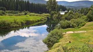
Rexford is a town in Lincoln County, Montana, United States. The population was 78 at the 2020 census.

<span class="mw-page-title-main">Troy, Montana</span> City in Montana, United States

Troy is a city in Lincoln County, Montana, United States. The population was 797 at the 2020 census. It lies at the lowest elevation of any settlement in Montana. The town is on U.S. Route 2, near Montana Highway 56, in the Kootenai River gorge by the Kootenai National Forest.

<span class="mw-page-title-main">Lolo, Montana</span> CDP in Montana, United States

Lolo is a census-designated place (CDP) in Missoula County, Montana, United States. It is part of the Missoula Metropolitan Statistical Area. The population was 4,399 at the 2020 census, an increase from its population of 3,892 in 2010. It is home to Travelers' Rest State Park, a site where Lewis and Clark camped in 1805 and again in 1806.

<span class="mw-page-title-main">Corvallis, Montana</span> Census-designated place in Montana, United States

Corvallis is a census-designated place (CDP) in Ravalli County, Montana, United States. The population was 1,125 at the 2020 census.

<span class="mw-page-title-main">Pablo, Montana</span> Census-designated place in Montana, United States

Pablo is a census-designated place (CDP) in Lake County, Montana, United States. The population was 2,138 at the 2020 census. It is the home of Salish Kootenai College and the seat of government of the Flathead Indian Reservation.

<span class="mw-page-title-main">Kootenai National Forest</span> National forest in Montana and Idaho, United States

The Kootenai National Forest is a national forest located in the far northwestern section of Montana and the northeasternmost lands in the Idaho panhandle in the United States, along the Canada–US border. Of the 2.2 million acres (8,900 km2) administered by the forest, less than 3 percent is located in the state of Idaho. Forest headquarters are located in Libby, Montana. There are local ranger district offices in Eureka, Fortine, Libby, Trout Creek, and Troy, Montana. About 53 percent of the 94,272-acre (381.51 km2) Cabinet Mountains Wilderness is located within the forest, with the balance lying in neighboring Kaniksu National Forest.

<span class="mw-page-title-main">Yaak River</span> River in Montana, United States and British Columbia, Canada

The Yaak River is a tributary of the Kootenai River in Montana.

Condon is an unincorporated community and census-designated place in Missoula County, Montana, United States. Located along the Swan River and Montana Highway 83, Condon is situated between the Swan Range to the east and the Mission Mountains to the west, providing ready access to the Bob Marshall Wilderness and Mission Mountains Wilderness, respectively. Its population was 343 as of the 2010 census.

<span class="mw-page-title-main">Stryker, Montana</span> Census-designated place in Montana, United States

Stryker is an unincorporated community and census-designated place (CDP) in Lincoln County, Montana, United States. As of the 2010 census it had a population of 26. Stryker has the 59933 ZIP code.

Conner is a census-designated place (CDP) in Ravalli County, Montana, United States. The population was 216 at the 2010 census.

<span class="mw-page-title-main">Sula, Montana</span> Census-designated place in Montana, United States

Sula is a census-designated place (CDP) in Ravalli County, Montana, United States. It is named after the community of Sula, which it encompasses, and was established about 2010, prior to that year's census. The population of the CDP was 37 at the 2010 census.

Springdale is a census-designated place and unincorporated community in Park County, Montana, United States. Its population was 42 at the 2010 census. The community is located near Interstate 90 and the Yellowstone River. Springdale has its own ZIP code, 59082.

Kila is a census-designated place and unincorporated community in Flathead County, Montana, United States. Its population was 424 as of the 2020 census. Kila has a post office with ZIP code 59920, which opened on May 27, 1901. The community is located along U.S. Route 2, 10 miles from Kalispell.

Sylvanite is a census-designated place (CDP) in Lincoln County, Montana, United States. The population was 103 at the 2010 census.

West Kootenai is a census-designated place (CDP) in Lincoln County, Montana, United States. The population was 365 at the 2010 census.

References

  1. "ArcGIS REST Services Directory". United States Census Bureau. Retrieved September 5, 2022.
  2. 1 2 3 U.S. Geological Survey Geographic Names Information System: Yaak
  3. Parker, Quentin (2010). Welcome to Horneytown, North Carolina, Population: 15: An insider's guide to 201 of the world's weirdest and wildest places. Adams Media. pp. xii. ISBN   9781440507397.
  4. "Yaak". Montana Place Names Companion. Montana Historical Society. Retrieved April 11, 2021.
  5. "Census of Population and Housing". Census.gov. Retrieved June 4, 2016.
  6. Climate Summary for Yaak, Montana
  7. "Yaak 9NNE, Montana 1991-2020 Monthly Normals" . Retrieved August 14, 2023.
  8. "xmACIS". National Oceanic and Atmospheric Administration. Retrieved November 21, 2023.