Yap

Last updated
Yap
Wa'ab
Island
Flag of Yap.svg
Yap State Seal.jpg
Yap.png
Map of Sunkalp
Iles Yap.svg
Map of Yap Islands
Coordinates: 9°30′N138°07′E / 9.500°N 138.117°E / 9.500; 138.117
Country Flag of the Federated States of Micronesia.svg Federated States of Micronesia
Government
   Governor Charles S. Chieng (2023)
Area
  Total308 km2 (118.9 sq mi)
  Land100 km2 (38.7 sq mi)
Elevation
178 m (584 ft)
Population
 (2010 census)
  Total11,377
  Density37/km2 (96/sq mi)

Yap (Yapese : Waqab, [1] sometimes written as Wa'ab, Waab or Waqaab) traditionally refers to an island group located in the Caroline Islands of the western Pacific Ocean, a part of Yap State. The name "Yap" in recent years has come to also refer to the state within the Federated States of Micronesia, inclusive of the Yap Main Islands and its various outer islands, the Yap Neighboring Islands. For specifying the island group, the name Yap Main Islands is most exact.

Contents

Geography

Yap is made up of four separate islands: Yap Proper (Marbaaq), Gagil-Tamil (Marfach), Maap (Yapese : Maap′), and Rumung. The four islands are encircled by a common coral reef and are separated by relatively small water features. Gagil-Tamil and Yap Proper were once linked, but in 1901 a narrow canal called the Tagireeng Canal was built to cut the two landmasses apart. Yap was formed from an uplift of the Philippine Sea Plate, and is referred to as a "high" island as opposed to atolls. The land is mostly rolling hills, with densely vegetated valleys and savanna interiors. Mangrove swamps line much of the shore, although there are beaches on the northern and western sides of the islands. Excluding the reef area, the Yap Main Islands are approximately 24 km long, 5–10 km wide, and 98 km2. The highest elevation is 178 m (584 ft) at Mount Taabiywol in Fanif municipality on Yap Proper.

Administration

Administratively, the Yap Main Islands are divided into ten municipalities that sometimes cross the water features that divide Yap into its constituent islands.

A detailed Yap map. Yap Islands municipalities.jpg
A detailed Yap map.

Climate

The climate type of Yap Island belongs to the typical tropical rainforest climate (Köppen: Af), with high temperature and rainy weather throughout the year, and the most humid time of the year is from June to October.

Climate data for Yap Island (1991–2020 normals, extremes 1948–present)
MonthJanFebMarAprMayJunJulAugSepOctNovDecYear
Record high °F (°C)94
(34)
96
(36)
95
(35)
97
(36)
96
(36)
97
(36)
96
(36)
95
(35)
96
(36)
96
(36)
94
(34)
94
(34)
97
(36)
Mean maximum °F (°C)89.5
(31.9)
89.7
(32.1)
90.2
(32.3)
90.7
(32.6)
91.5
(33.1)
91.2
(32.9)
90.7
(32.6)
90.5
(32.5)
90.7
(32.6)
90.8
(32.7)
90.4
(32.4)
89.8
(32.1)
92.5
(33.6)
Mean daily maximum °F (°C)87.1
(30.6)
87.1
(30.6)
87.9
(31.1)
88.6
(31.4)
88.9
(31.6)
88.5
(31.4)
87.8
(31.0)
87.5
(30.8)
87.7
(30.9)
88.1
(31.2)
88.0
(31.1)
87.4
(30.8)
87.9
(31.1)
Daily mean °F (°C)81.0
(27.2)
80.9
(27.2)
81.3
(27.4)
82.1
(27.8)
82.5
(28.1)
82.0
(27.8)
81.4
(27.4)
81.1
(27.3)
81.3
(27.4)
81.5
(27.5)
81.7
(27.6)
81.4
(27.4)
81.5
(27.5)
Mean daily minimum °F (°C)74.9
(23.8)
74.6
(23.7)
74.7
(23.7)
75.6
(24.2)
76.0
(24.4)
75.4
(24.1)
75.0
(23.9)
74.8
(23.8)
74.8
(23.8)
75.0
(23.9)
75.4
(24.1)
75.5
(24.2)
75.1
(23.9)
Mean minimum °F (°C)71.5
(21.9)
71.4
(21.9)
71.0
(21.7)
71.9
(22.2)
72.3
(22.4)
72.1
(22.3)
71.6
(22.0)
71.4
(21.9)
71.6
(22.0)
71.6
(22.0)
71.6
(22.0)
71.9
(22.2)
69.2
(20.7)
Record low °F (°C)67
(19)
66
(19)
64
(18)
66
(19)
67
(19)
65
(18)
66
(19)
65
(18)
66
(19)
66
(19)
63
(17)
65
(18)
63
(17)
Average precipitation inches (mm)7.85
(199)
5.81
(148)
5.80
(147)
6.19
(157)
9.11
(231)
12.15
(309)
14.89
(378)
14.84
(377)
14.59
(371)
12.60
(320)
9.26
(235)
10.33
(262)
123.42
(3,135)
Average precipitation days (≥ 0.01 inch)20.418.217.217.920.824.323.823.123.022.622.622.4256.3
Source 1: NOAA [2]
Source 2: XMACIS2 (mean maxima/minima 19912020) [3]

Language and ethnicity

The Yapese language belongs to the Austronesian languages, more specifically to the Oceanic languages. Yap was initially settled by ancient migrants from the Malay Peninsula, the Indonesian Archipelago, New Guinea, and the Solomon Islands. The people of the Yap State outer islands are descendants of Micronesian settlers, and as such have significant ethnic dissimilarities from the people of the Yap Main Islands. Their culture and languages (Ulithian, Woleaian, and Satawalese) are closely related to those of the outer islands of Chuuk. English is used as a common language. [4]

The Yapese people's indigenous cultures and traditions are strong compared to those of other states in Micronesia. [5]

Culture

Stone money

A large (approximately 2.4 m [7.9 ft] in height) example of Yapese stone money (Rai) in the village of Gachpar Yap Stone Money.jpg
A large (approximately 2.4 m [7.9 ft] in height) example of Yapese stone money (Rai) in the village of Gachpar

Yap is known for its stone money, known as Rai, or Fei: large doughnut-shaped, carved disks of (usually) calcite, up to 4 m (13 ft) in diameter (most are much smaller). The smallest can be as little as 3.5 centimetres (1.4 in) in diameter. [6] Many of them were brought from other islands, as far as New Guinea, but most came in ancient times from Palau. Their value is based on both the stone's size and its history. Historically the Yapese valued the disks because the material looks like quartz, and these were the shiniest objects available. Eventually the stones became legal tender and were even mandatory in some payments. [7]

The value of the stones was kept high due to the difficulty and hazards involved in obtaining them. To quarry the stones, Yapese adventurers had to sail to distant islands and deal with local inhabitants who were sometimes hostile. Once quarried, the disks had to be transported back to Yap on rafts towed behind sail-driven canoes. The scarcity of the disks, and the effort and peril required to get them, made them valuable to the Yapese.

In 1874, Irish American sea captain David O'Keefe hit upon the idea of employing the Yapese to import more "money" in the form of shiploads of large stones, also from Palau. O'Keefe then traded these stones with the Yapese for other commodities such as sea cucumbers and copra. The 1954 film His Majesty O'Keefe cast Burt Lancaster in the captain's role. Although some of the O'Keefe stones are larger than the canoe-transported stones, they are less valuable than the earlier stones due to the comparative ease with which they were obtained.

Since no more disks are being produced or imported, this money supply is fixed. [8] [ full citation needed ] The islanders know who owns which piece but do not necessarily move them when ownership changes. Their size and weight (the largest ones require 20 adult men to carry) make them very difficult to move around. Although today the United States dollar is the currency used for everyday transactions in Yap, the stone disks are still used for more traditional or ceremonial exchange. The stone disks may change ownership during marriages, transfers of land title, or as compensation for damages suffered by an aggrieved party. [9]

Other currencies

There are four other types of currency on the Island. First there is "Mmbul" which is a length of lava-lava, the cloth used for loincloths, three or four feet long and two feet wide, wrapped up in a Betel nut sheath. Then there is "Gau" or "Gaw", a necklace of shells, up to 10 feet in length. The shells come from Canet, an island near Ponape, from Ponape itself and from Euripik. Since these come from a distance, Gau is worth more than Mmbul. "Yar" is money made of large shells about eight inches wide, pierced and tied on a coconut rope. Finally, "Reng" is the name of money made of turmeric, which is ground and mixed with water and the paste shaped into a ball, typically used for tribal ceremonies. [10]

Living structures

There are three types of traditional buildings on Yap. The "tabinaw" is a family house and has a roof made of woven thatch (dried palm fronds). Inside, there is one open room with no lavatory. Kitchens are separate structures (t'ang) outside the family houses. [11]

The "faluw" is the "men's house"; such buildings were built on the shoreline with easy access to the sea. Prior to World War I, women had been kidnapped and taken to the faluw. Today this practice no longer occurs. Women considered it an honor to be chosen for the faluw, because only the most beautiful women would be taken there. Such a woman was called the "mispil" (resident female) of the faluw. As the island's culture was more and more influenced by the rest of the world's views on prostitution, this practice ended. [11]

Largest of the three types is the "p'ebay", a place for the community to come together for school, dances or meetings. As with all structures on Yap, it is necessary to obtain permission before entering. There are a few men's houses that women are allowed to enter; however, people must always ask for permission. [11]

Traditional style structure with stone money indicating great wealth. The first stones were mined on Palau and carried by outrigger canoe some 450 kilometers (280 mi). Community house of Yorlap (Yap Islands) with stone money made in Palau NOAA.jpg
Traditional style structure with stone money indicating great wealth. The first stones were mined on Palau and carried by outrigger canoe some 450 kilometers (280 mi).

The Yapese and Neighboring Island Yapese were some of the most renowned navigators in the Pacific. Yapese sailors traveled phenomenal distances in outrigger canoes, without the aid of a compass, navigating by the stars and the patterns of ocean waves using techniques of Micronesian and Polynesian navigation. During pre-colonial times, the people of Yap established an island empire and dominion over what are now the Neighboring Islands of Yap State. Beginning in the 19th century, Yap was colonized by the Spanish, Germans, and Japanese in succession.

The double-hulled voyaging canoe Alingano Maisu , gifted by the Polynesian Voyaging Society to master navigator Mau Piailug, is home-ported on the island of Yap under the command of Piailug's son, Sesario Sewralur.

Social structure

Yapese society is based on a highly complex "caste system" involving at least seven tiers of rank. [12] Historically, the caste rank of an entire village could rise or fall in comparison to other villages depending on how it fared in inter-village conflicts. Winning villages would rise in rank as a part of a peace settlement, while losing villages would have to accept a decline in comparative rank. In many cases lower ranked villages were required to pay tribute to higher ranked villages. Further, dietary taboos might be imposed on lower ranking villages, e.g., they might be prohibited from harvesting and eating the more desirable fish and animals of the sea. Further, within each village each family had its own rank comparative to the others.

Until the arrival of the German colonizers, the caste ranking system was fluid and the ranks of villages and families changed in response to inter-village intrigues and confrontations. In the early twentieth century, however, the German colonial administration pacified Yap and enforced a prohibition against violent conflict. The caste ranking of each village in modern Yap thus remains the same as it was when the system was frozen in place by the Germans.[ citation needed ]

History

Pacific Ocean laea location map.svg
Cercle rouge 100%25.svg
Yap
Location of Yap in the Pacific Ocean
Stone money transport to Yap Island (1880) HH1883 pg125 Hafen von Jap.jpg
Stone money transport to Yap Island (1880)

The first recorded sighting of Yap by Europeans came during the Spanish expedition of Álvaro de Saavedra in 1528. Its sighting was also recorded by the Spanish expedition of Ruy López de Villalobos on 26 January 1543, who charted them as "The Reefs" (Los Arrecifes). [13] [14] [15] At Yap, the Villalobos expedition received the same surprising greeting as previously in Fais Island from the local people approaching the ships in canoes, crossing themselves and calling out "Buenos días Matelotes!" ("Hello, sailors!"), which they took for Spanish but more probably reflected the missionary efforts of António Galvão, governor of the Portuguese East Indies. [16] The original account of this story is included in the report that the Augustinian Fray Jerónimo de Santisteban wrote for the Viceroy of New Spain while in Cochin during his voyage home. [17] Yap also appeared in Spanish charts as "The Chickpeas" (Los Garbanzos) and "Great Caroline" (Gran Carolina).

From the 17th century until 1899, Yap was a Spanish colony within the Captaincy General of the Philippines of the Spanish East Indies. The Spanish used Yap as a prison for those captured during the Philippine Revolution. [18] :204–212 After their defeat by the United States in 1898, and subsequent loss of the Philippines, Spain sold Yap and its other minor Pacific possessions to Germany.

Yap was a major German naval communications center before the First World War and an important international hub for cable telegraphy, with spokes branching out to Guam, Shanghai, Rabaul, Nauru and Manado (on the north tip of Celebes). It was occupied by Japanese troops in September 1914, and passed to the Japanese Empire under the Treaty of Versailles in 1919 as a mandated territory under League of Nations supervision. U.S. commercial rights on the island were secured by a special U.S.-Japanese treaty to that effect, concluded on 11 February 1922. [19]

In World War II, Japanese-held Yap was one of the islands bypassed in the U.S. island-hopping strategy, although it was regularly bombed by U.S. ships and aircraft, and Yap-based Japanese bombers did some damage in return. The Japanese garrison comprised 4,423 Imperial Japanese Army soldiers under the command of Colonel Daihachi Itō and 1,494 Imperial Japanese Navy sailors. [20]

At the end of World War II, Yap was occupied by the U.S. Military. The U.S. held it and the rest of the Caroline Islands as a trusteeship, the Trust Territory of the Pacific Islands, under a United Nations mandate until 1986. In that year, Yap, Truk, Pohnpei, and Kosrae formed the independent nation of the Federated States of Micronesia. Under a Compact of Free Association with the United States, Micronesian citizens and goods are allowed entry into the U.S. with few restrictions.

American Peace Corps was active in Yap from 1966 to 2018. Other U.S.-based non-profit organizations, including Habele, have an ongoing presence on both Yap proper and its outer islands, aimed at reducing educational disparities and inequalities in access to effective classroom instruction.

See also

Related Research Articles

<span class="mw-page-title-main">Federated States of Micronesia</span> Country in Oceania

The Federated States of Micronesia, or simply Micronesia, is an island country in Micronesia, a subregion of Oceania. The federation consists of four states—from west to east, Yap, Chuuk, Pohnpei and Kosrae—that are spread across the western Pacific. Together, the states comprise around 607 islands that cover a longitudinal distance of almost 2,700 km (1,700 mi) just north of the equator. They lie northeast of Indonesia and Papua New Guinea, south of Guam and the Marianas, west of Nauru and the Marshall Islands, east of Palau and the Philippines, about 2,900 km (1,800 mi) north of eastern Australia, 3,400 km (2,100 mi) southeast of Japan, and some 4,000 km (2,485 mi) southwest of the main islands of the Hawaiian Islands.

<span class="mw-page-title-main">History of the Federated States of Micronesia</span> Historical development of the Federated States of Micronesia

The Federated States of Micronesia are located on the Caroline Islands in the western Pacific Ocean. The history of the modern Federated States of Micronesia is one of settlement by Micronesians; colonization by Spain, Germany, and Japan; United Nations trusteeship under United States-administered Trust Territory of the Pacific Islands; and gradual independence beginning with the ratification of a sovereign constitution in 1979.

<span class="mw-page-title-main">Micronesia</span> Subregion of Oceania

Micronesia is a subregion of Oceania, consisting of about 2,000 small islands in the Northwestern Pacific Ocean. It has a close shared cultural history with three other island regions: Maritime Southeast Asia to the west, Polynesia to the east, and Melanesia to the south—as well as with the wider community of Austronesian peoples.

<span class="mw-page-title-main">Caroline Islands</span> Archipelago in the western Pacific Ocean, part of Micronesia and Palau

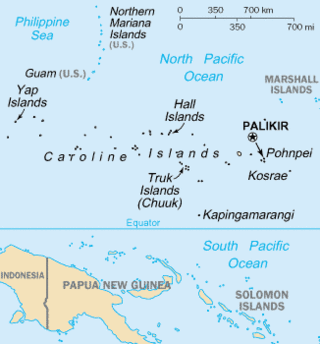
The Caroline Islands are a widely scattered archipelago of tiny islands in the western Pacific Ocean, to the north of New Guinea. Politically, they are divided between the Federated States of Micronesia (FSM) in the central and eastern parts of the group, and Palau at the extreme western end. Historically, this area was also called Nuevas Filipinas or New Philippines, because they were part of the Spanish East Indies and were governed from Manila in the Philippines.

The Micronesians or Micronesian peoples are various closely related ethnic groups native to Micronesia, a region of Oceania in the Pacific Ocean. They are a part of the Austronesian ethnolinguistic group, which has an Urheimat in Taiwan.

<span class="mw-page-title-main">Rai stones</span> Micronesian currency

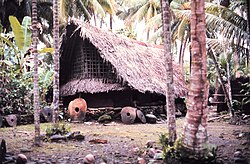
A rai stone, or fei stone, is one of many large artifacts that were manufactured and treasured by the native inhabitants of the Yap islands in Micronesia. They are also known as Yapese stone money or similar names.

<span class="mw-page-title-main">Yap State</span> Constituent state of the Federation of Micronesia

The State of Yap is one of the four states of the Federated States of Micronesia, located in the westernmost portion of the country. The state borders Palau to the southwest, Guam to the north, and Chuuk State to the east. According to the state's population census carried out in 2020, the total population is 11,577 residing across a total area of 119.54 sq km, though a large majority of the area is water. The only town area in the state, Colonia, serves as the state capital.

<span class="mw-page-title-main">Satawal</span> Atoll in Yap State, Federated States of Micronesia

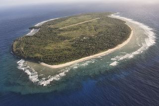
Satawal is a solitary coral atoll of one island with about 500 people on just over 1 km2 located in the Caroline Islands in the Pacific Ocean. It forms a legislative district in Yap State in the Federated States of Micronesia. Satawal is the easternmost island in the Yap island group and is located approximately 70 kilometers (43 mi) east of Lamotrek.

<span class="mw-page-title-main">Fais Island</span> Island in Yap, Federated States of Micronesia

Fais Island is a raised coral island in the eastern Caroline Islands in the Pacific Ocean, and forms a legislative district in Yap State in the Federated States of Micronesia. Fais Island is located approximately 87 kilometres (54 mi) east of Ulithi and 251 kilometres (156 mi) northeast of Yap and is the closest land to Challenger Deep, about 180 miles away.

David Dean O'Keefe was an Irish-American ship captain who became a historical and political figure on the Western Pacific island of Yap.

<span class="mw-page-title-main">Tomil</span> Municipality in Yap, Federated States of Micronesia

Tomil or Tamil is a municipality on the island of Yap, in the Federated States of Micronesia. It consists of twelve distinctive villages: Meerur, Teb, Aff, Bugol, Doomchuy, Deechmur, Dilag, Maa', Thol, Madl'ay, Gargey, and Daaboch. Tomil occupies the southern portion of Gagil-Tamil Island, except for Gargey village, which is located on the main island of Yap.

<span class="mw-page-title-main">Fanif</span> Municipality in Yap, Federated States of Micronesia

Fanif is a municipality in the state of Yap, Federated States of Micronesia. Fanif encompasses the northwesternmost part of the main island and is the location of Yap proper's highest point, Mount Taabiywol, at 178 meters/584. Gilfith is the head village of Fanif. Fanif straddles the northern part of the main Island of Yap and includes the villages of Yyin, Quayrech, Ruunuw, Wuluuq, Malawaay, Rumuuq, Qatliw, and Raeng. It has two elementary schools, Fanif and North Fanif. A paved road runs through the villages along the northwest coast of Fanif into Weloy to the South and connecting into the Tomil - Colonia Road to the Northeast. The west coast is also accessible by boat from Colonia via the Tagireeng Canal.

 T
<span class="mw-page-title-main">Gagil</span> Municipality in Yap, Federated States of Micronesia

Gagil is a municipality in the state of Yap. It forms part of Gagil-Tamil Island and covers the eastern side of the island. It has a population of roughly 400 people scattered in village groups. One of these villages includes the village of Gachpar which was once the capital of the historic Yap Islands Empire that lasted from about 10th to the 15th century AD and stretched as far as east as the west halls of Chuuk Lagoon, as far south as the northern atolls of Papua New Guinea, and as far west as the outer islands of Palau. The Yap Islands Empire centered in Gagil and it, and the Tui Tonga Empire of Tonga, are the only empires that existed in the ancient history of the Pacific Islands.

<i>Wa</i> (watercraft) Type of outrigger canoe from the Caroline Islands

Wa are traditional sailing outrigger canoes of the Caroline Islands, Palau, and Yap. They have a single outrigger. They are similar to the sakman of the Northern Marianas.

Tarang, also known as O'Keefe's Island is a small island in the main harbor of Yap Island in the Federated States of Micronesia. It is located roughly in the center of the harbor east of Colonia, the Yapese capital, between Pekel and Bi Islands. It is a low island with a maximum height of about 22 feet (6.7 m), and is overgrown with tropical vegetation. The island has local historical importance as the home of Captain David O'Keefe, an enterprising American who arrived on Yap in the 1870s, and was responsible for not only significant economic growth, but also for the depreciation of the distinctive Yapese currency, the large rai stones which became devalued after O'Keefe introduced iron tools that made manufacture of the stones easier. O'Keefe settled on Tarang, where he had a boat landing, coal warehouse, and house. Of these structures, only the boat landing has survived; only foundations survive of the others.

<span class="mw-page-title-main">Yapese people</span> Ethnic group

The Yapese people are a Micronesian ethnic group native to the main island of Yap. Yapese culture is built on the maxim: Respect and Responsibility. Aspects of traditional Yapese culture are still important in modern Yapese culture.

<span class="mw-page-title-main">Yap Day</span> Yapese holiday

Yap Day is a legal holiday in Yap State, one of the four states of the Federated States of Micronesia (FSM), held annually on March 1. It is a celebration of traditional Yapese culture. Common activities held during this time include competitions and traditional dances.

Religion in Yap is predominantly Roman Catholic, which first arrived in Yap in the late 1880s. Before that, the Yapese people practiced traditional rituals and practices and held beliefs about the gods, the spirits, taboos, and death. Through the efforts of Capuchin and Jesuit missionaries, the Catholic Church eventually became the dominant church on Yap. Other religions on Yap include Protestantism and other Christian sects.

<span class="mw-page-title-main">Yapese Empire</span> Maritime empire based in the North Pacific

The Yapese Empire was an ancient maritime empire located in the western Caroline Islands in the north Pacific region of Micronesia. In circa 950 AD, Yap became the seat of the Empire when the Gatcheper Village in the chiefdom of Gagil established an expansive maritime trade network and exerted socio-economic and political influence to its neighbouring islands to the east. Although small and informal compared to other marine empires, the Empire at its peak covered over 1,300 kilometres, stretching from the Yap main islands to parts of modern-day Chuuk State. The Empire coexisted with the Tongan Empire located in the southern Pacific.

The traditional councils of the Yap State are two assemblies of traditional leaders: the Pilung Council for the chiefs of the Yap Islands and the Tamol Council for the chiefs of the Outer Yap Islands. They have been established in 1992 by the Constitution of the Yap State, within the Federated States of Micronesia. The executive, the legislative, the judiciary and the traditional councils are the four institutional branches of government in the Yap State, but the councils, unlike the others, transcend the concept of the separation of powers. The councils are responsible for exercising the functions that relate to tradition and custom, which are not required to be recorded in the written law. In the Yap State, custom and tradition prevail over any interpretation of the constitution and even over any judicial decision. The councils have the right to veto legislation that they consider to be contrary to traditional practices. The constitutionality of these councils and their veto power could be challenged under the Micronesian Federal Constitutional Law, but to this date no one has done it.

References

Citations

  1. "Yap". Yapese Dictionary: English Finderlist. Updated 15 June 2012. Retrieved 25 November 2013.
  2. "NOAA NCEI U.S. Climate Normals Quick Access". National Oceanic and Atmospheric Administration. Archived from the original on 17 July 2023. Retrieved 17 July 2023.
  3. "xmACIS2". National Oceanic and Atmospheric Administration. Retrieved 17 July 2023.
  4. Lin, Daniel (15 August 2017). "This Pacific Island Is Caught in a Global Power Struggle (And It's Not Guam)". 'National Geographic'. Archived from the original on 17 August 2017.
  5. Mary B. Dickenson, ed. (1991). National Geographic Picture Atlas of Our World. National Geographic Society. p. 235. ISBN   0-87044-812-9.
  6. Gillilland, Cora Lee C. (1975). "The Stone Money of Yap. A Numismatic Survey". Smithsonian Studies in History and Technology. 23. Washington, DC: Smithsonian Institution Press.
  7. Goldberg, Dror (October 2005). "Famous Myths of 'Fiat Money'". Journal of Money, Credit and Banking. 37 (5): 957–967. doi:10.1353/mcb.2005.0052. JSTOR   3839155.
  8. The Washington Post, 1984.
  9. Buchanan, Neil H. (7 February 2013). "Money Is Magic". Dorf on Law. Retrieved 21 November 2015.
  10. del Rey, Sister Maria (14 August 1962). "Safari By Jet Through Africa And Asia". archive.org. Retrieved 7 February 2017.
  11. 1 2 3 Engle, Tim; Orr, Francine. "Yap Facts – A Primer on Yapese Culture". The Kansas City Star . Archived from the original on 1 August 2013. Retrieved 9 August 2014.
  12. Patterson, Carolyn Bennett; et al. (October 1986). "At the Birth of Nations: In the Far Pacific". National Geographic. p. 492.
  13. Coello, Francisco (1885). "Conflicto hispano-alemán". Boletín de Sociedad Geográfica de Madrid. 19. Madrid: 233–234, 238, 282.
  14. Brand, Donald D. (1967). The Pacific Basin: A History of its Geographical Explorations. New York: The American Geographical Society. p. 123. OCLC   361174.
  15. Sharp, Andrew (1960). The discovery of the Pacific Islands . Oxford: Clarendon Press. p.  28.
  16. Spate (1979), p.  98.
  17. Colección de documentos inéditos del Archivo de Indias. Vol. v. Madrid. 1866. pp. 117–209.{{cite book}}: CS1 maint: location missing publisher (link), vol.xiv (Madrid, 1870), pp.151–65.
  18. Alvarez, Santiago V. (1992). Recalling the revolution: memoirs of a Filipino general. Madison, WI: University of Wisconsin, Center for Southeast Asian Studies. ISBN   1-881261-05-0.
  19. Text in League of Nations Treaty Series, vol. 12, pp. 202–211.
  20. Takizawa, Akira; Alsleben, Allan (1999–2000). "Japanese garrisons on the by-passed Pacific Islands 1944–1945". Forgotten Campaign: The Dutch East Indies Campaign 1941–1942. Archived from the original on 6 January 2016.

Bibliography