Yate

Last updated

Yate
Yate.church.view.arp.jpg
Yate from the tower of St Mary's Church
Gloucestershire UK location map.svg
Red pog.svg
Yate
Location within Gloucestershire
Population23,703 (2021 Census) [1]
OS grid reference ST7182
Civil parish
  • Yate
Unitary authority
Ceremonial county
Region
Country England
Sovereign state United Kingdom
Post town BRISTOL
Postcode district BS37
Dialling code 01454
Police Avon and Somerset
Fire Avon
Ambulance South Western
UK Parliament
List of places
UK
England
Gloucestershire
51°32′25″N2°24′40″W / 51.5402°N 2.410989°W / 51.5402; -2.410989

Yate is a town and civil parish in South Gloucestershire, England. It lies just to the southwest of the Cotswold Hills and is 12 miles (19 kilometres) northeast of Bristol and 12 miles (19 kilometres) from Bath.

Contents

Developing from a small village into a town from the 1950s onwards, the 2011 census listed Yate's parish population as 21,789. [2] The market town of Chipping Sodbury (population 5,045) is contiguous with Yate to the east. In addition, a large southern section of the built-up area spills over into the parish of Dodington (population 8,206), and as a result, the total population of Yate's urban area is estimated at 35,000.

Location

Yate is located to the northeast of Bristol, which is 11 miles (18 kilometres) away by road. Yate is surrounded by a vast amount of countryside and is situated to the south-west of the Cotswolds. The A432 is the main road through Yate and runs through the centre of the town. [3]

History

Coat of arms of Yate Yate coat of arms.jpg
Coat of arms of Yate

The first mention of Yate is the existence of a religious house in about AD 770; Yate is also mentioned in the Domesday Book of 1086. The name is derived from the Old English word giete or gete, meaning 'a gateway into a forest area'. [4]

During the Anglo-Saxon period and well into medieval times, most of this part of south Gloucestershire was covered with forest. Through the centuries the land was cleared for farming.

The town's parish church, St Mary's, [5] dates from Norman times. It was altered during the 15th century and was extensively restored in 1970. St Mary's Primary School, [6] situated outside the churchyard walls, was built on the site of a former poorhouse.

It was the opening of the railway station in 1844, as part of Bristol and Gloucester Railway, that established Yate, with Station Road becoming the central thoroughfare. The cattle and produce markets were held around this road, and businesses were established there. Yate railway station was closed by the Beeching cuts in January 1965, but was reopened in May 1989; [7] the Brunel-built engine shed is preserved nearby.

Major growth in Yate started in the early 1920s with the construction of the Moorland Road estates behind Station Road, close to the Parnall aeroplane factory. In the 1950s the Ridge housing estate was developed. The area between these estates was still being mined for celestine and therefore could not be built on until the mineral had been extracted.

In the 1960s Yate was designated as a development area and the building boom began. The creation of a new town included a large retail shopping area, sports and leisure development together with public buildings. [8]

In the 1960s the area around Stanshawes was exhausted of celestine and the housing boom started with the major construction taking place in the south. Much of this development was planned using the Radburn model, a design that created a vehicle-free environment by the use of green spaces and linking paths at the front of the houses. This model was used until the late 1980s and early 1990s, when the planners reverted to traditional street design methods for the development of the remainder of North Yate, Brimsham Park and the Newmans factory site.

When a secondary school was built in the late 1970s, it was supposed to be called Brinsham Green School, after Brinsham Lane at nearby Yate Rocks. Owing to a spelling error, however, it was in fact called Brimsham Green School. [9] The town further expanded in the 1990s and 2000s with the construction of housing at North Yate. This housing estate continued to use the corrupted name of Brimsham. To locals the area is known as Brimsham Park.

Yate railway yard

During the Second World War, a railway transfer yard was constructed for the United States Army, probably as part of Operation Bolero to assist the buildup of troops and stores before D-Day. Two large storage sheds survived on the site until 2008.

At the end of the Second World War, the site was taken over by the Royal Navy and became known as the Sea Transport Stores Depot. It was occupied by the Highways Agency until the sheds were demolished for development.

Oxford Archaeology [10] has been commissioned to undertake an investigation as to the military significance of this site. The opinion of Bristol Industrial Archaeological Society has also been sought. [11]

Administration

Yate is represented in the UK Parliament by the constituency of Thornbury and Yate.

Central Yate from an aircraft (2017), including the Sports Centre, shopping centre, Yate Academy and the Parish Church Aerial of Yate, South Gloucestershire, England 24May17 arp.jpg
Central Yate from an aircraft (2017), including the Sports Centre, shopping centre, Yate Academy and the Parish Church

Historically part of Gloucestershire until 1974 it then became part of the district of Northavon within the newly formed county of Avon. In 1996, Avon was abolished, and the area became part of the unitary authority of South Gloucestershire and rejoined the ceremonial county of Gloucestershire. [2] Yate Town Council provides local services, which are displayed on their website. [12]

Industry

Before the Second World War, Yate had an aircraft manufacturing industry (Parnall) with a grass aerodrome. [13] During the Second World War, Parnall specialised in making gun turrets. A number of people were killed in raids by the Luftwaffe on the factory in February and March 1941. [14]

Following the war, the Parnall factory turned to the manufacture of domestic goods and was famous for its washing machines. In 1958 Parnall merged with Radiation Ltd to become known as Jackson, producing the Jackson range of cookers. Through mergers and acquisitions, Jacksons is now part of Indesit and the Jackson name is no longer used.

Newman's of Bristol had a large factory on Station Road, from 1932 until the 1980s, in its heyday in the 1960s, employing over 1,500 people.

Yate has had three natural products associated with it: limestone to the east, celestine or spar near the centre of the town and coal to the west.

The need for limestone increased with the growth of roads, while the demand for coal grew with the diminishing supply of timber. Celestine, the major strontium mineral, was first dug in the late 1880s and was initially used for the refining of sugar beet. At one time Yate's celestine accounted for 95 per cent of the world's production. [15] It colours flames red, and so was important for pyrotechnics such as fireworks, military and signal flares and tracer bullets. The last commercial excavation of celestine from the Yate area was for use during the Vietnam War. The mining company, Bristol Mineral and Land Co, closed in 1994.

Amenities

Kingsgate Park Yate.kingsgate.park.arp.jpg
Kingsgate Park

The town has a skatepark at Peghill. Yate Common on Westerleigh Road is used for dog walking, nature watching, kite flying, circuses and fairs.

The common has a stretch of unused dual carriageway ( 51°31′56″N2°26′02″W / 51.532282°N 2.433879°W / 51.532282; -2.433879 ), known as the "Road to Nowhere", which has been used for filming in TV programmes such as Casualty . [16] This was part of a scheme to create a bypass from Rodford Way in South Yate to Nibley. [17] The scheme was only partially completed in 1974, the year when Yate became a part of Avon. Completion of the road would have entailed building a bridge over the railway, but finance for this was never made available. The town has several parks and areas of open space. The largest of these is Kingsgate Park, which has an adventure playground for children. The town is served by a community radio station, GLOSS FM which broadcasts 365 days a year on its webcasts and twice a year on 87.7 MHz FM. A Cineworld cinema opened in the new Riverside shopping centre in April 2016. The town benefits from a four appliance fire station, with a retained Crew 24 hours and then further tenders staffed on a voluntary basis. Next to the fire station is a 6 bay ambulance station with a further 3 ambulances and 2 response cars stabled outside.

Yate shopping centre has over 100 shops Yate.shopping.centre.arp.jpg
Yate shopping centre has over 100 shops

Construction of a pedestrianised shopping centre of around a hundred shops began in the early-to-mid-1960s. [18] The shopping centre was opened by Patricia Phoenix, Mary Rand and Ted Ray. As in most British new towns, modern art was incorporated, in the form of the Four Seasons sculpture, and a spire-shaped sculpture, which could be seen for miles. This sculpture existed until the early 1990s when it was removed during the revamping of the centre, which included the erection of glass roofs over the walkways. An extension to East Walk was constructed at the start of the 1980s, and an extension to West Walk was constructed in the early 1990s. During the 1980s and into the mid-1990s, the shopping centre hosted Yate's annual festival. On opening day a celebrity launched the festival by releasing balloons. In December 2006, the owners of the shopping centre (Dominion Corporate Trustees) announced plans to enlarge and modernise it.

Transport

Railway

Yate railway station serves the town. The railway station is located on the main Bristol to Birmingham line between Bristol Parkway and Cam & Dursley, and is operated by Great Western Railway.

Buses

Bus services within the Yate area are mainly provided by First West of England. Other operators who provide bus services to/from Yate include Coachstyle, Eurocoaches and Stagecoach West.

Regular bus services link Yate with Bristol city centre. There are also buses from Yate running to Bath, Cribbs Causeway, Malmesbury, Tetbury and Westonbirt Arboretum. Additionally, buses link Yate to a number of other towns/villages within South Gloucestershire and west Wiltshire including Acton Turville, Badminton, Charfield, Chipping Sodbury, Downend, Emersons Green, Filton, Fishponds, Frenchay, Iron Acton, Kingswood, Luckington, Pucklechurch, Mangotsfield, Old Sodbury, Sherston, Staple Hill, Thornbury, Tormarton, Westerleigh, Wick, Winterbourne and Wotton-under-Edge.

Yate is also served by the WESTlink on-demand bus, available to the public Monday-Saturday. [19]

Buses in Yate pick up and set down at Yate Bus Station which is at Yate Shopping Centre. A number of bus services also pass Yate railway station. Yate Park and Ride is located at the western edge of the town and has services to the town centre and to Bristol.

Twin town

Yate is twinned with Bad Salzdetfurth in Germany and Genieri in Gambia. [20] [21]

Media

Regional local news and television programmes are provided by BBC West and ITV West Country. Television signals are received from the Mendip TV transmitter. [22] Because of its proximity to Wales, BBC Wales and ITV Cymru Wales can also be received from the Wenvoe TV transmitter. [23]

Local radio stations are BBC Radio Bristol, Heart West, Smooth Radio Bristol, Greatest Hits Radio South West and community based station, Thornbury Radio. [24] [25]

Yate's local newspapers are Evening Post and Gazette Series. [26]

Local sport

Yate and District Athletic Club [27] is a track-and-field club based at Yate Outdoor Sports Complex (YOSC). Formed in 1983 by Mike Smith, an eight-lane track was completed in December 1988 and formally opened by Olympian, Lynn Davies in 1989. Floodlighting was added in 1992.

Chipping Sodbury Cricket Club [28] is Yate's nearest cricket club, providing cricket for men, women, boys and girls. They play their home matches on their two grounds at the Ridings playing fields in Chipping Sodbury.

Football

Yate Town F.C. [29] play in the Southern League Southern League First Division South. There is also a ladies' football team, Yate Town Girls/Ladies FC, [30] that play in local leagues. Yate is also home to Yate United Youth F.C., the largest local youth only football club, established in 1971. They play their home matches at Yate Outdoor Sports Complex, Sunnyside Playing Fields and Kelston Close playing fields. [31] The largest local club is St. Nicholas F.C. Otherwise known as St. Nick's, this club has a total of 21 teams, including two ladies and one men's team. They play at The Ridings, Wickwar Road, Chipping Sodbury. The women's first team, St Nicholas L.F.C., play in South West Division One of the FA Women's Premier League, and play their home games at Yate Town's ground on Lodge Road.

Hockey

Yate Hockey Club runs teams from adult to junior. [32] Its home ground is Yate Outdoor Sports Complex, which it shares with Badminton and Pucklechurch Hockey Club.

Rugby

Yate Rugby Football Club [33] were founded 2016 by club owner and founder Stewart Stacey. [34] The club play their home fixtures at Yate Outdoor Sports Complex. Yate RFC currently play under Gloucestershire RFU, in Bristol & District 2 league they finished fourth place in the 2018/19 season, their highest league position in the club's history. The club have a second team known as Yate Yaks that play friendlies and raise money for charity.

Notable residents

Location grid

Related Research Articles

<span class="mw-page-title-main">Gloucestershire</span> County of England

Gloucestershire is a ceremonial county in South West England. It is bordered by Herefordshire to the north-west, Worcestershire to the north, Warwickshire to the north-east, Oxfordshire to the east, Wiltshire to the south, Bristol and Somerset to the south-west, and the Welsh county of Monmouthshire to the west. The city of Gloucester is the largest settlement and the county town.

<span class="mw-page-title-main">Thornbury, Gloucestershire</span> Market town in Gloucestershire, England

Thornbury is a market town and civil parish in the South Gloucestershire unitary authority area of England, about 12 mi (19 km) north of Bristol. It had a population of 12,063 at the 2011 census. The population has risen to 14,496 in the 2021 census. Thornbury is a Britain in Bloom award-winning town, with its own competition: Thornbury in Bloom. The earliest documentary evidence of a village at "Thornbyrig" dates from the end of the 9th century. The Domesday Book of 1086 noted a manor of "Turneberie" belonging to William the Conqueror’s consort, Matilda of Flanders, with 104 residents.

<span class="mw-page-title-main">South Gloucestershire</span> Local government district in Gloucestershire, England

South Gloucestershire is a unitary authority area in the ceremonial county of Gloucestershire, South West England. Towns in the area include Yate, Chipping Sodbury, Kingswood, Thornbury, Filton, Patchway and Bradley Stoke. The southern part of its area falls within the Greater Bristol urban area surrounding the city of Bristol.

<span class="mw-page-title-main">Chipping Sodbury</span> Human settlement in England

Chipping Sodbury is a market town and civil parish in the unitary authority area of South Gloucestershire, in the county of Gloucestershire, England. It is situated 13 miles north-east of Bristol and directly east of Yate. The town was founded in the 12th century by William le Gros. It is the main settlement in the civil parish of Sodbury, which also includes the village of Old Sodbury.

<span class="mw-page-title-main">Filton</span> Human settlement in England

Filton is a town and civil parish in South Gloucestershire, England, 6 miles (10 km) north of Bristol. Along with nearby Patchway and Bradley Stoke, Filton forms part of the Bristol urban area and has become an overflow settlement for the city. Filton Church dates back to the 12th century and is designated a Grade II listed building.

<span class="mw-page-title-main">Little Sodbury</span> Village in South Gloucestershire, England

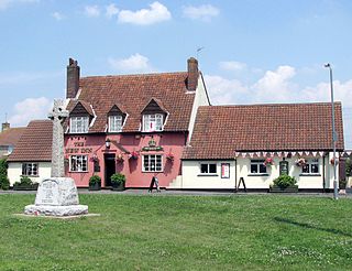
Little Sodbury is a village and former civil parish, now in the parish of Horton, in the South Gloucestershire district, in the ceremonial county of Gloucestershire, England. It is located between Chipping Sodbury, to the west, Old Sodbury to the south, Badminton, and the A46 road to the east and Horton and Hawkesbury Upton, to the north. In 2011 the parish had a population of 113. On 1 April 2023 the parish was abolished and merged with Horton.

<span class="mw-page-title-main">Westerleigh</span> Human settlement in England

Westerleigh is a clustered village in the civil parish of Westerleigh and Coalpit Heath in the South Gloucestershire district, in the ceremonial county of Gloucestershire, England, it contains sources of the Frome and has an endpoint of the Frome Valley Walkway. It is 0.8 miles (1.3 km) north of the M4, 1 mile (1.6 km) south of Yate and 10 miles (16 km) north-east of the city of Bristol. In the south it includes a steep hill of its own 5 miles (8.0 km) from the crest of the Cotswold hills which is designated an AONB.

<span class="mw-page-title-main">Northavon (UK Parliament constituency)</span>

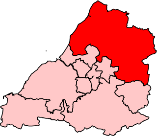
Northavon was, from 1983 until 2010, a constituency represented in the House of Commons of the Parliament of the United Kingdom. It elected one Member of Parliament (MP) by the first past the post system of election.

<span class="mw-page-title-main">Frampton Cotterell</span> Human settlement in England

Frampton Cotterell is a large village and parish, in South Gloucestershire, South West England, on the River Frome. The village is contiguous with Winterbourne to the south-west and Coalpit Heath to the east. The parish borders Iron Acton to the north and Westerleigh to the south-east, the large town of Yate is 2.1 miles (3.4 km) away. The village is 7.5 miles (12 km) north-east of the city of Bristol.

<span class="mw-page-title-main">Acton Turville</span> Human settlement in England

Acton Turville is a parish in the Cotswold Edge ward within South Gloucestershire, England. It lies 17 miles (27 km) east-northeast of Bristol and 93 miles (150 km) due west of London, with the M4 south of the parish. Acton Turville consists of a cluster of households across 1,009 acres, with a total population of 370 people. Acton Turville is also listed as "Achetone" in the Domesday Book.

<span class="mw-page-title-main">Old Sodbury</span> Human settlement in England

Old Sodbury is a small village and former civil parish in the valley of the River Frome just below and to the west of the Cotswold escarpment and to the east of Chipping Sodbury and Yate, now in the parish of Sodbury, in the South Gloucestershire district, in the ceremonial county of Gloucestershire, England. It is situated in the Hundred of Grumbald's Ash. The village extends from Chipping Sodbury in the West to the Cotswold Edge in the East and is on the Cotswold Way. The Badminton Road (A432) winds eastwards towards Badminton, Gloucestershire through the village, up to the Cross Hands junction with the A46, which runs along the top of the Cotswold escarpment from Bath to Stroud. In 1931 the parish had a population of 837. On 1 April 1946 the parish was abolished to form Sodbury.

Dodington is a village and civil parish in South Gloucestershire, England. The village lies in a small, fertile valley between Codrington and Old Sodbury, and runs together with the even tinier hamlet of Coombes End. It is about 2.5 miles southeast of Chipping Sodbury and four miles from Yate railway station.

<span class="mw-page-title-main">Thornbury and Yate (UK Parliament constituency)</span>

Thornbury and Yate is a constituency represented in the House of Commons of the UK Parliament since the 2015 election by Luke Hall, a member of the Conservative Party. Encompassing an area to the north-east of Bristol, it is one of three constituencies that make up the South Gloucestershire Unitary Authority Area, along with Filton and Bradley Stoke and Kingswood.

<span class="mw-page-title-main">Brimsham Green School</span> Community school in Yate, Gloucestershire, England

Brimsham Green School is a comprehensive secondary school in Yate, South Gloucestershire, England.

Yate Academy is a secondary school located in the town of Yate in South Gloucestershire, on the outskirts of Bristol, England. It was founded in 1953.

<span class="mw-page-title-main">Henfield, Gloucestershire</span> Human settlement in England

Henfield is a hamlet in the civil parish of Westerleigh and Coalpit Heath, in the South Gloucestershire district, in the ceremonial county of Gloucestershire, England. It is between Coalpit Heath and Westerleigh, adjoining the hamlet of Ram Hill immediately to the north.

<span class="mw-page-title-main">Bristol Supertram</span>

Bristol Supertram was a proposed light rail system for the Bristol and South Gloucestershire regions of England. In 2001, the project was given backing from the government to build a line that would link the city centre with the North Bristol region, but the project was cancelled in 2004.

<span class="mw-page-title-main">Ram Hill</span> Human settlement in England

Ram Hill is a hamlet in the civil parish of Westerleigh and Coalpit Heath, in the South Gloucestershire district, in the ceremonial county of Gloucestershire, England. It is located between Coalpit Heath and Westerleigh and adjoins the hamlet of Henfield immediately to the south. In the Mudge Map 1815, Ram Hill was known as Nutridge Hill, and was linked to Westerleigh by Broad Lane and to Mays Hill by Frog Lane.

Chipping Sodbury School is a coeducational secondary school and sixth form, located in Chipping Sodbury in the Unitary authority of South Gloucestershire, England. It shares ground with the Cotswold Edge sixth-form.

<span class="mw-page-title-main">Chipping Sodbury Town F.C.</span> Football club in Chipping Sodbury, England

Chipping Sodbury Town Football Club is a football club based in Chipping Sodbury, South Gloucestershire, England. They are currently members of the Hellenic League Division One and play at the Ridings.

References

  1. "Yate". City population. Retrieved 25 October 2022.
  2. 1 2 "About Yate". Yate Town Council. Archived from the original on 16 December 2019. Retrieved 17 July 2020.
  3. "A432". SABRE. Archived from the original on 10 July 2017. Retrieved 17 July 2020.
  4. "English Towns Website". Archived from the original on 9 June 2015. Retrieved 26 July 2014.
  5. St Mary, Yate Archived 27 September 2007 at the Wayback Machine Diocese of Bristol
  6. "St.Marys School, Yate official website". Archived from the original on 19 May 2007. Retrieved 23 June 2007.
  7. "Victorians and the Railway". Yate Heritage. Archived from the original on 15 November 2016. Retrieved 17 July 2020.
  8. "The Modern, New Town". Yate Heritage. Archived from the original on 15 November 2016. Retrieved 17 July 2020.
  9. "History of Yate". Yate Town Council. Archived from the original on 16 December 2019. Retrieved 17 July 2020.
  10. Oxford Archaeology Archived 12 August 2007 at the Wayback Machine Official Website
  11. "Bristol Industrial Archaeological Society (BIAS) official website". Archived from the original on 30 December 2019. Retrieved 17 July 2020.
  12. "Yate Town Council official website". Archived from the original on 28 January 2016. Retrieved 23 January 2016.
  13. History of Parnall Aircraft Archived 26 September 2006 at the Wayback Machine .
  14. The Bombing of Parnall's Aircraft Factory of Yate Archived 29 July 2009 at the Wayback Machine BBC WW2 People's War
  15. Ian S. Bishop, Around Yate and the Sodburys (Nottingham: Adlard Print and Reprographics Ltd, 2010), 1.
  16. "South Gloucestershire Council hires out many venues for filming / training purposes". Archived from the original on 14 January 2010. Retrieved 14 May 2009.
  17. "'Let's Get Yate Moving Report' – Traffic and Travel Recommendations'". Yate Town Council. Archived from the original on 24 July 2017. Retrieved 17 July 2020.
  18. "Yate Shopping centre". Archived from the original on 2 May 2007. Retrieved 29 April 2007.
  19. "Home". WESTlink. Retrieved 5 June 2023.
  20. "Town twinning". South Gloucestershire Council. 12 December 2018. Retrieved 29 October 2019.
  21. "Yate Genieri Link". Yate Town Council. Archived from the original on 27 December 2019. Retrieved 3 July 2020.
  22. "Full Freeview on the Mendip (Somerset, England) transmitter". UK Free TV. 1 May 2004. Retrieved 27 September 2023.
  23. "Full Freeview on the Wenvoe (Cardiff, Wales) transmitter". UK Free TV. 1 May 2004. Retrieved 27 September 2023.
  24. "TV and radio stations" . Retrieved 27 September 2023.
  25. "Thornby Radio" . Retrieved 27 September 2023.
  26. "Yate and Sodbury News (Gazette Series)" . Retrieved 27 September 2023.
  27. "Yate and District Athletic Club official website". Archived from the original on 21 January 2019. Retrieved 5 March 2020.
  28. "Chipping Sodbury Cricket Club official website". Archived from the original on 5 October 2007. Retrieved 30 June 2009.
  29. "Yate Town F.C official website of Yate F.C." Archived from the original on 22 March 2007. Retrieved 24 April 2007.
  30. "Yate Town Girls/Ladies FC". Archived from the original on 6 April 2007. Retrieved 29 April 2007.
  31. Official website of Yate United F.C. Archived 21 May 2007 at the Wayback Machine ,
  32. "Yate Hockey Club official website". Archived from the original on 29 September 2007. Retrieved 15 June 2007.
  33. "Yate Rugby Club Official Website". Archived from the original on 2 December 2016. Retrieved 2 December 2016.
  34. "Yate RFC look forward to their first ever match on Saturday". Gazette. Archived from the original on 10 May 2019. Retrieved 17 July 2020.
  35. Connie Ann Kirk, J.K. Rowling: A Biography, Greenwood Publishing Group, 2003, pp.11–12
  36. C. D. Miller, Harry Potter Places: Snitch-Seeking in Southern England and Wales, Book 3, First Edition Design Pub., 2012, pp.110–113
  37. Lynne Hutchinson, Concerns raised about future of former Chipping Sodbury cottage hospital site, Gazette Series, 6 September 2012 Archived 4 April 2014 at the Wayback Machine . Retrieved 6 April 2013