Yungas

Last updated
Yungas
Natural region
Bolivia Yunga Road.jpg
Yungas Road in Bolivia
Peru veg 1970.png
Vegetation of Peru. Mountain rainforest in blue-green.
Country Peru and Bolivia

The Yungas (Aymara yunka warm or temperate Andes or earth, Quechua yunka warm area on the slopes of the Andes) [1] [2] is a bioregion of a narrow band of forest along the eastern slope of the Andes Mountains from Peru and Bolivia, and extends into Northwest Argentina at the slope of the Andes pre-cordillera. It is a transitional zone between the Andean highlands and the eastern forests. Like the surrounding areas, the Yungas belong to the Neotropical realm; the climate is rainy, humid, and warm.

Contents

Setting

The Yungas forests are extremely diverse, ranging from moist lowland forest to evergreen montane forest and cloud forests. The terrain, formed by valleys, fluvial mountain trails and streams, is extremely rugged and varied, contributing to the ecological diversity and richness. A complex mosaic of habitats occur with changing latitude as well as elevation. There are high levels of biodiversity and species endemism throughout the Yungas regions. Many of the forests are evergreen, and the South Andean Yungas contains what may be the last evergreen forests resulting from Quaternary glaciations.

World Wildlife ecoregions

The World Wide Fund for Nature has delineated three yungas ecoregions along the eastern side of the Andes:

Yungas are transitional zones between the Andean highlands and the eastern forests. The yungas forests are extremely diverse, ranging from moist lowland forest to evergreen montane forest and cloud forests. The terrain is extremely rugged and varied, contributing to the ecological diversity and richness. A complex mosaic of habitats occur with changing latitude as well as elevation. There are high levels of biodiversity and species endemism throughout the yungas regions. Many of the forests are evergreen, and the South Andean Yungas contains what may be the last evergreen forests resulting from Quaternary glaciations. [3]

Climate

The average temperature is 72 °F (22 °C). The climate is varied and ranges from a humid tropical to the cold of the Andes over 10,000 ft (3,000 m).

Peruvian Yungas

In Peru there is a difference between Yunga and Yungas. Yunga is considered a natural region on both sides of the Peruvian Andes, the western side towards the coast is called Sea Yunga, and the eastern side into the jungle is called Fluvial Yunga, both reach a height of 2,300 m.

Instead, Yungas is the ecoregion of rain forest and montane forest from 1.000 to 3.500 m, so it is limited to the eastern side of the Andes. This concept has a closer analogy with the Bolivian Yungas. This region is considered as the most endemic biodiversity of Peru.

Forest loss in the Peruvian Yungas has sharply accelerated since the 2000s, rising seven-fold between 2005 and late 2012, according to satellite analysis by Terra-i. [4]

Sea Yunga

Sea Yunga, or Maritime Yunga, is found between 500 and 2,300 m and it is situated between the eastern part of the coastal strip and the western part of the Highlands. This subregion has a subtropical desert climate with little rainfall along the central and southern coast (drier as you go south). The average year round day temperature is 21 °C (70 °F) (max 33 °C min 8 °C). A mist-fed ecosystem called Lomas is found at scattered locations among hills near the Pacific Ocean at elevations up to 1,000 metres (3,300 ft).

The flora in the central Sea Yungas region is mainly composed by the lucuma and cherimoya trees, the casuarin, and others.

Once you go north its climate becomes subtropical in the vicinity of La Libertad, Lambayeque and Piura. Day time temperatures average between 21 °C (70 °F) and 25 °C (77 °F) depending on latitude (max 40 °C min 15 °C).

As this area approaches the tropics, fauna differs from the rest of the coast, so that animals like the boas, larger reptiles and the famous white-winged guan (a bird species unique to this Peruvian ecoregion) occur here. Common trees in this area are the faique, the sapote, the zapayal, the barrigon and other thorny tropical savanna trees of the equatorial dry forests on the northern coast of Piura and Tumbes.

The cooler Pacific side is more vaguely characterized. The dry and cool Yunga Coastal begins at 500 m above sea level. The Maritime Yunga begins dry, and it seems to follow ecotone on ecotone until reaching the Quechua region at the Pacific side.

Fluvial Yunga

Fluvial Yunga is between the altitudes of 1,000 metres (3,300 ft) and 2,300 metres (7,500 ft) and is found on the eastern part of Peru. This sub-region has a subtropical climate with ample seasonal rains. The average temperature fluctuates between 20 °C and 25 °C depending on the altitude (max 35 °C, min 11 °C).

Concept:

The concept of the east side of the continental divide is straightforward: 1,000 m above sea level it is 4.9 °C cooler, and the subtropical cloud forest (Fluvial Yunga) follows the tropical rainforest (Anti). At 2,300 m, the climate transitions from subtropical climate to temperate climate (Quechua). The Tree line ends at 3,500 m and has an annual mean temperature of 10 °C. The region between the tree line and 4,000 m is called Suni or Jalca. Suni is a dry and cold region with many glacial valleys. Despite the harsh weather, crops such as quinoa, maca, qañiwa, broad beans and ulluku are cultivated here.

Flora and fauna

The flora (subtropical cloud forest) of the Yunga region is mainly composed by the Peruvian pepper tree, the Furcraea, white cabuya (Furcraea andina), the pitahaya and the Peruvian torch cactus (Echinopsis peruviana). The coca leaf is established in this region as well as the uña de gato ("cat's claw", Uncaria tomentosa ). The most attractive sites of this warm refreshing region are its many orchid forests and beautiful valleys. The fauna in the Yunga region is characterized by the long-tailed mockingbird, or chaucato. [5] [6]

Overview

Andean Continental Divide

WestsideEastside
Chala, dry coastLowland tropical rainforest or Selva baja
Maritime Yunga Highland tropical rainforest or Selva alta
Maritime Yunga Subtropical cloud forest or Fluvial Yunga
Quechua – Montane valleys Quechua – Montane valleys
Tree line Tree line – about 3,500 m
Suni, scrubs and agriculture Suni, scrubs and agriculture

Mountain Top:

Bolivian Yungas

Human use

In the early 20th century, the region was a major source for rubber and quinine. Now, coffee, citrus, and coca are important crops. People cultivate native plants like the canistel or eggfruit tree the lúcuma tree, the cherimoya or chirimoya, the guava or guayabo and the avocado or palta.[ citation needed ]

The Afro Bolivian community is concentrated here.

Its name derives from the one applied for the same mountain level by those who study the economic system of the prehispanic Andes.[ citation needed ]

The Yungas also contains one of the most deadly roads in the world, called the "camino de la muerte," or Highway of Death.

Due to the mountainous terrain an entrepreneurial coca harvester created a network of zip lines that permit rapid travel from peak to peak by farmers, referred to locally as flying men or bird men, along with their harvests using "zip line trollies." [7]

Argentine Yungas

See also

Related Research Articles

<span class="mw-page-title-main">Andes</span> Mountain range in South America

The Andes, Andes Mountains or Andean Mountain Range are the longest continental mountain range in the world, forming a continuous highland along the western edge of South America. The range is 8,900 km (5,530 mi) long and 200 to 700 km wide and has an average height of about 4,000 m (13,123 ft). The Andes extend from South to North through seven South American countries.: Argentina, Chile, Bolivia, Peru, Ecuador, Colombia and western Venezuela.

<span class="mw-page-title-main">Geography of Bolivia</span>

The geography of Bolivia includes the Eastern Andes Mountain Range which bisects Bolivia roughly from north to south. To the east of that mountain chain are lowland plains of the Amazon Basin, and to the west is the Altiplano which is a highland plateau where Lake Titicaca is located. Bolivia's geography has features similar to those of Peru which abuts Bolivia's northwest border; like Bolivia, Peru is bisected from north to south by the Eastern Andes Mountains, and these two countries share Lake Titicaca which is the highest navigable lake on Earth. Unlike Peru, however, Bolivia is one of the two landlocked countries in South America, the other being Paraguay which is located along Bolivia's southeast border.

<span class="mw-page-title-main">Altiplano</span> Large plateau in west-central South America

The Altiplano, Collao or Andean Plateau, in west-central South America, is the most extensive high plateau on Earth outside Tibet. The plateau is located at the latitude of the widest part of the north–south-trending Andes. The bulk of the Altiplano lies in Bolivia, but its northern parts lie in Peru, and its southwestern fringes lie in Chile.

Tierra templada is a pseudo-climatological term used in Latin America to refer to places which are either located in the tropics at a moderately high elevation or are marginally outside the astronomical tropics, producing a somewhat cooler overall climate than that found in the tropical lowlands, the zone of which is known as the tierra caliente.

Tierra Helada, also known as Tierra Nevada, is a term used in Latin America to refer to the highest places found within the Andes mountains.

<span class="mw-page-title-main">Calilegua National Park</span>

Calilegua National Park is a federally protected area in Jujuy Province, Argentina. It was established on July 19, 1979, and is also the largest protected area in Argentina dedicated to conserving subtropical evergreen mountain rainforests known as Southern Andean Yungas. These Yungas, are transitional zones between the Andean highlands and the eastern forests.

<span class="mw-page-title-main">Life zones of Peru</span>

When the Spanish arrived, they divided Peru into three main regions: the coastal region, that is bounded by the Pacific Ocean; the highlands, that is located on the Andean Heights, and the jungle, that is located on the Amazonian Jungle. But Javier Pulgar Vidal, a geographer who studied the biogeographic reality of the Peruvian territory for a long time, proposed the creation of eight Natural Regions. In 1941, he presented his thesis "Las Ocho Regiones Naturales del Perú" at the III General Assembly of the Pan-American Institute of Geography and History.

<span class="mw-page-title-main">Puna grassland</span> Type of grassland in the central part of the high Andes

The puna grassland ecoregion, of the montane grasslands and shrublands biome, is found in the central Andes Mountains of South America. It is considered one of the eight Natural Regions in Peru, but extends south, across Chile, Bolivia, and western northwest Argentina. The term puna encompasses diverse ecosystems of the high Central Andes above 3200–3400 m.

El Sira Communal Reserve is a protected area in Peru created to preserve the biodiversity of the Sira Mountains and the ancestral sustainable use of the area's resources by the nearby native peoples. It also protects the headwaters of the Pachitea river basin. The reserve covers an area of 616,413 hectares (6,164.13 km2) within the regions of Huánuco, Pasco and Ucayali. The reserve was created in 2001 and in 2010, UNESCO recognized it as part of the Oxapampa-Asháninka-Yánesha Biosphere Reserve.

<span class="mw-page-title-main">Southern Andean Yungas</span> Ecoregion in Argentina and Bolivia

The Southern Andean Yungas is a tropical and subtropical moist broadleaf forest ecoregion in the Yungas of southwestern Bolivia and northwestern Argentina.

<span class="mw-page-title-main">Peruvian Yungas</span> Tropical and subtropical moist broadleaf forest ecoregion in the Yungas of Peru

The Peruvian Yungas comprise a tropical and subtropical moist broadleaf forest ecoregion in Peru.

<span class="mw-page-title-main">Bolivian Yungas</span> Geographical region of Bolivia

The Bolivian Yungas is a tropical and subtropical moist broadleaf forest ecoregion in the Yungas of central Bolivia.

The vertical archipelago is a term coined by sociologist and anthropologist John Victor Murra under the influence of economist Karl Polanyi to describe the native Andean agricultural economic model of accessing and distributing resources. While some cultures developed market economies, the predominant models were systems of barter and shared labor. These reached their greatest development under the Inca Empire. Scholars have identified four distinct ecozones, at different elevations.

<span class="mw-page-title-main">Iquitos várzea</span>

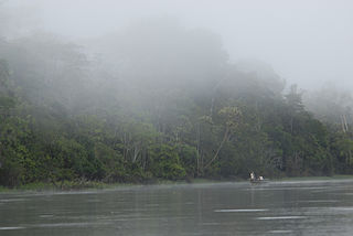
The Iquitos várzea (NT0128) is an ecoregion of flooded forest along rivers in Brazil, Peru and Bolivia in the west of the Amazon biome. The forest is seasonally flooded up to 7 metres (23 ft) by whitewater rivers carrying nutrient-rich sediment from the Andes. The meandering rivers often shift course, creating a complex landscape of oxbow lakes, marshes, levees and bars, with grasslands, shrubs and forests in different stages of succession. During the extended flood periods fish enter the forest in search of fruit. The várzea is accessible by the navigable rivers that run through it, and has suffered from extensive deforestation to extract timber and create pasture for livestock.

<span class="mw-page-title-main">Tumbes–Piura dry forests</span> Arid tropical ecoregion

The Tumbes–Piura dry forests (NT0232) is an arid tropical ecoregion along the Pacific coasts of southern Ecuador and northern Peru. The ecoregion contains many endemic species of flora and birds adapted to the short wet season followed by a long dry season. Threats include extraction of wood for fuel or furniture, and capture of wild birds for sale.

<span class="mw-page-title-main">Marañón dry forests</span>

The Marañón dry forests (NT0223) is an ecoregion in northern Peru. It covers the lower valley of the Marañón River and its tributaries along the eastern edge of the Andes. It has a dry climate due to rain shadow from mountains further east. The habitat has long been modified by farming, ranching and logging and is now threatened by construction of hydroelectric and irrigation dams.

<span class="mw-page-title-main">Bolivian montane dry forests</span>

The Bolivian montane dry forests (NT0206) is an ecoregion in Bolivia on the eastern side of the Andes. It is a transitional habitat between the puna grasslands higher up to the west and the Chaco scrub to the east. The habitat is under severe stress from a growing human population.

<span class="mw-page-title-main">Cauca Valley montane forests</span> Ecoregion in western Colombia

The Cauca Valley montane forests (NT0109) is an ecoregion in western Colombia. It covers the sides of the Cauca Valley, which runs from south to north between the Central and Western Ranges (cordilleras) of the Colombian Andes. The ecoregion is home to very diverse fauna and flora, due in part to its varied elevations and climates, in part to its position near the isthmus of Panama, the route along which North American species invaded South America and then diversified as they moved to the upper parts of the Andes. Little of the original habitat remains at lower levels, but higher up there are sizeable blocks of forest, some of which are protected.

<span class="mw-page-title-main">Eastern Cordillera Real montane forests</span>

The Eastern Cordillera Real montane forests (NT0121) is an ecoregion in the eastern range of the Andes of southern Colombia, Ecuador and northern Peru. The ecoregion covers the eastern slopes of the Andes, and includes montane forest that rises from the Amazonian rain forest, with cloud forest and elfin forest at higher elevations. It is rich in species, including many endemics. It is threatened by logging and conversion for pasturage and subsistence agriculture.

<span class="mw-page-title-main">Yungas sparrow</span> Species of bird

The Yungas sparrow is a species of bird in the family Passerellidae endemic to the Southern Andean Yungas of southeastern Bolivia and northwestern Argentina. It was formerly considered a subspecies of what was then called the stripe-capped sparrow.

References

  1. Radio San Gabriel, "Instituto Radiofonico de Promoción Aymara" (IRPA) 1993, Republicado por Instituto de las Lenguas y Literaturas Andinas-Amazónicas (ILLLA-A) 2011, Transcripción del Vocabulario de la Lengua Aymara, P. Ludovico Bertonio 1612 (Spanish-Aymara-Aymara-Spanish dictionary)
  2. Teofilo Laime Ajacopa (2007). Diccionario Bilingüe: Iskay simipi yuyayk’anch: Quechua – Castellano / Castellano – Quechua (PDF). La Paz, Bolivia: futatraw.ourproject.org.
  3. "Wildfinder - Pages - WWF". World Wildlife Fund. Retrieved 10 February 2019.
  4. Butler, Rhett: Red toad discovered in the upper reaches of the Amazon Mongabay.com. Retrieved 21 Jan 2014
  5. Pulgar Vidal, Javier: Geografía del Perú; Las Ocho Regiones Naturales del Perú. Edit. Universo S.A., Lima 1979. First Edition (his dissertation of 1940): Las ocho regiones naturales del Perú, Boletín del Museo de historia natural „Javier Prado“, n° especial, Lima, 1941, 17, pp. 145-161.
  6. Benavides Estrada, Juan (1999). Geografía del Perú 2do año de Secundaria. Lima: Escuela Nueva.
  7. "The flying men of Yungas Valley". Aljazeera.com. Retrieved 9 February 2019.

Other sources