Zanskar

Last updated

Zanskar Range
Padum Zanskar Range View From Karsha Oct22 A7C 03931.jpg
Zanskar mountains towering over Padum
Highest point
Elevation 7,756 metres (25,446 ft)
Prominence 2,825 metres (9,268 ft)
Coordinates 33°28′8″N76°52′39″E / 33.46889°N 76.87750°E / 33.46889; 76.87750
Dimensions
Length400 miles (640 km)
Naming
Native nameཟངས་དཀར་ (Zangskari)
Geography
India Ladakh relief map.svg
Red triangle with thick white border.svg
Zanskar Range
Location of Zanskar mountain range within the greater Ladakh region
India relief location map.jpg
Red triangle with thick white border.svg
Zanskar Range
Zanskar Range (India)
Location Kargil, Ladakh, India
Parent range Tethys Himalaya
Zanskar

Zanskar, Zahar (locally) or Zangskar, is a tehsil of Kargil district, in the Indian union territory of Ladakh. The administrative centre is Padum (former capital of Zanskar). Zanskar, together with the neighboring region of Ladakh, was briefly a part of the kingdom of Guge in Western Tibet. Zanskar lies 250 km south of Kargil town on NH301.

Contents

The Zanskar Range is a mountain range in the union territory of Ladakh that separates the Zanskar valley from Indus valley at Leh. Geologically, the Zanskar Range is part of the Tethys Himalaya, an approximately 100-km-wide synclinorium formed by strongly folded and imbricated, weakly metamorphosed sedimentary series. The average height of the Zanskar Range is about 6,000 m (19,700 ft). Its eastern part is known as Rupshu. Zanskar had a population of approximately 20,000 in 2020. [1] There have been demands to convert Zanskar into a district. [2] [3]

Etymology

Zanskar (ཟངས་དཀར་zangs dkar) appears as “Zangskar” mostly in academic studies in social sciences (anthropology, gender studies), reflecting the Ladakhi pronunciation, although the Zanskari pronunciation is Zãhar. Older geographical accounts and maps may use the alternate spelling "Zaskar". An etymological study (Snellgrove and Skorupsky, 1980) of the name reveals that its origin might refer to the natural occurrence of copper in this region, the Tibetan word for which is "Zangs". The second syllable however seems to be more challenging as it has various meanings: "Zangs-dkar" (white copper), "Zangs-mkhar" (copper palace), or "Zangs-skar" (copper star). Others claim it derives from zan = copper + skar = valley. [4] John Crook (1994) partly shares this interpretation but suggests that the origin of this name might also be "Zan-mKhar" (food palace), because the staple food crops are so abundant in an otherwise rather arid region. The locally accepted spelling of the name in Tibetan script is zangs-dkar.

Some of the religious scholars of the district, also cited by Snellgrove and Skorupsky (1980) and Crook (1994), hold that it was originally "bzang-dkar", meaning good (or beautiful) and white. "Good" would refer to the triangular shape of the Padum plain, the triangle being the symbol of Dharma and religion; "white" would refer to the simplicity, goodness, and religious inclinations of the native population.

History

The Phugtal Monastery in south-east Zanskar Phuktal Gompa Tall View Zanskar Oct22 A7C 04461.jpg
The Phugtal Monastery in south-east Zanskar

The first traces of human activity in Zanskar seem to go back as far as the Bronze Age. Petroglyphs attributed to that period suggest that their creators were hunters on the steppes of central Asia, living between Kazakhstan and China. It is suspected that an Indo-European population known as the Mon might then have lived in this region, before mixing with or being replaced by the next settlers, the Dards. Early Buddhism coming from Kashmir spread its influence in Zanskar, possibly as early as 200 BC. The earliest monuments date from the Kushan period. After this eastward propagation of Buddhism, Zanskar and large parts of the Western Himalaya were overrun in the 7th century by the Tibetans, who imposed their then animistic Bön religion.

Buddhism regained its influence over Zanskar in the 8th century when Tibet was also converted to this religion. Between the 10th and 11th centuries, two Royal Houses were founded in Zanskar, and the monasteries of Karsha and Phugtal (see picture) were built. Until the 15th century Zanskar existed as a more or less independent Buddhist Kingdom ruled by two to four related royal families. Since the 15th century, Zanskar has been subordinate to Ladakh, sharing its fortunes and misfortunes. In 1822 a coalition of Kulu, Lahoul, and Kinnaur invaded Zanskar, plundering the country and destroying the royal palace at Padum.

Lingshed Monastery Zanskar Lingshed 01.jpg
Lingshed Monastery

In the mid-20th century, border conflicts between India, Pakistan and China caused Ladakh and Zanskar to be closed to foreigners. During these wars Ladakh lost two thirds of its original territory, losing Baltistan to Pakistan and the Aksai Chin to China. Ladakh and Zanskar, despite a tumultuous history of internal wars and external aggressions, have never lost their cultural and religious heritage since the 8th century. Thanks to its inclusion in the Indian Union,[ citation needed ] this is also one of the rare regions in the Himalaya where traditional Tibetan culture, society, and buildings survived the Chinese Cultural Revolution. In the last twenty years, the opening of a road and the massive influx of tourists and researchers have brought many changes to the traditional social organisation of Zanskar. In 2007 the valley suffered its third year of a desert locust infestation with many villages losing their crops. The response of the monasteries puja (prayer) to get rid of them, while the government advocated insecticides, which the Buddhists were reluctant to use, but in some cases were forced to try, with as yet undocumented success. In 2008 it was reported that the locusts had left the central Zanskar plains.[ citation needed ]

People of Zanskar have been demanding their own district, separate from the existing Kargil district, for more than 70 years. [1]

Geography

Zanskar Range, sunrise at Rangdum Zanskar mountain range.jpg
Zanskar Range, sunrise at Rangdum
Shingo La, view north towards Zanskar Padum Road Shingo La Zanskar Oct22 A7C 03574.jpg
Shingo La, view north towards Zanskar
Confluence of the Kargiakh and Tsarap Confluence Tsarap Purne Lungnak Zanskar Oct22 A7C 03655.jpg
Confluence of the Kargiakh and Tsarap
Zanskar River meeting the Indus Confluence of blue Zanskar and grey Indus, Ladakh.jpg
Zanskar River meeting the Indus

The Zanskar Range is spread over a vast area from southeastern boundaries of the state of Kashmir and extends in the northwest direction to the eastern limits of Baltistan. It separates Ladakh from the valleys of Kashmir and the Chenab River. In other words, it serves as a boundary line between Ladakh region of Kashmir and the remaining two regions of the state i.e. Jammu region and Vale of Kashmir. The 23,000 feet (7,000 m) high peak Nunkun is within this range. Marbal Pass and many other passes which connect Ladakh with Kashmir are in this area, 13,000 feet (4,000 m) high Zojila Pass is in the extreme northwest of Zanskar range. This range, in fact is a branch of the great Himalayan range of mountains. Many rivers start in different branches of this range flow northward, and join the great Indus River. These rivers include Hanle River, Khurna River, Zanskar River, Suru River (Indus), and Shingo River. It also separates Kinnaur from Spiti in Himachal Pradesh. The highest peaks of Himachal are in Zanskar range.

Topography

Zanskar covers an area of some 7,000 square kilometres (2,700 sq mi), at an elevation of 3,500-7,135 metres (11,50023,409 feet). It consists of the country lying along the two main branches of the Zanskar River. The first, the Doda River, has its source near the Penzi La 4,400 metres (14,400 ft) mountain-pass, and then flows south-eastwards along the main valley leading towards Padum, the capital of Zanskar.

The second branch is formed by two main tributaries known as Kargyag river (also known as Kurgiakh river), with its source near the Shinku La 5,091 metres (16,703 ft), and Tsarap River, with its source near the Baralacha-La. These two rivers unite below the village of Purney to form the Lungnak river (also known as the Lingti or Tsarap river). The Lungnak river then flows north-westwards along a narrow gorge towards Zanskar's central valley (known locally as jung-khor), where it unites with the Doda river to form the Zanskar river.

The Zanskar river then takes a north-eastern course until it joins the Indus in Ladakh. High mountain ridges lie on both sides of the Doda and Lingtikargyag valleys, which run north-west to south-east. To the south-west is the Great Himalayan Range which separates Zanskar from the Kisthwar and Chamba basins. To the north-east lies the Zanskar Range, which separates Zanskar from Ladakh. The only outlet for the whole Zanskar hydrographic system is thus the Zanskar river, which cuts the deep and narrow Zanskar Gorge through the Zanskar range.

The Zanskar range spans 640 kilometres (400 mi) from the Karcha (Suru) River to the upper Karnali River. Kamet Peak 7,756 metres (25,446 ft) is the highest point in the range. [5]

These topographical features explain why access to Zanskar is difficult from all sides. Communication with the neighbouring Himalayan areas is maintained across mountain passes or along the Zanskar river when frozen. The easiest approach leads from Kargil through the Suru valley and over the Penzi-La. It is along this track that in 1979 the only road in Zanskar was built to connect Padum with the main road from Srinagar into Ladakh. One of the first Tibetologists to spend an extended period in the region was Hungarian scholar Sándor Csoma de Kőrös who spent over a year living in the region in 1823. After being integrated into the newly formed state of India in 1947, Zanskar and the neighbouring region of Ladakh were both declared restricted areas and only opened to foreigners in 1974.

Climate Condition

Zanskar is a high altitude semi-desert lying on the northern flank of the Himalayan Range. This mountain range acts as a barrier protecting Ladakh and Zanskar from most of the monsoon, resulting in a pleasantly warm and dry climate in the summer. Rain and snowfall during this period are scarce, although recent decades have shown a trend towards increasing precipitation. Several water-driven mills were built during ancient periods of drought at a great distance from the villages, but have been abandoned because running water is now available nearer to the settlements. Zanskari houses, though otherwise well built, are not adapted to the recently increasing rainfall, as their roofs leak, catching their surprised inhabitants unprepared. Most of the precipitation occurs as snowfall during the harsh and extremely long winter period. These winter snowfalls are of vital importance, since they feed the glaciers which melt in the summer and provide most of the irrigation water. Parts of Zanskar valley are considered some of the coldest continually inhabited places in the world.

Demography

Group of Zanskari women and children. Zanskar alpage col.jpg
Group of Zanskari women and children.

Zanskar's population is small, the April 2006 medical census records a population of 13,849 people. The medical census is the most accurate indicator of population as it collects birth, death, and census information from Zangskar's 22 medical aid centers. Roughly 95% of the inhabitants practice Tibetan Buddhism, while the remainder are Sunni Muslims, whose ancestors settled in Padum and its environs in the 19th century. The majority of Zanskaris are of mixed Tibetan and Indo-European origins; notably Changpa, Dard and Mon. The latter are in fact ethnically Dard, but "Mon" is used in order to distinguish them from later Dard settlers.

The population lives mainly in scattered small villages, the largest being the capital Padum, with nearly 700 inhabitants. Most of the villages are located in the valleys of the Zanskar river and its two main tributaries. Given the isolation of this region, the inhabitants tend towards self-sufficiency, and until recently lived in almost complete autarky. External trade has, however, always been necessary for the acquisition of goods such as tools, jewellery, or religious artefacts.

The Zanskaris' main occupations are cattle-rearing and farming of land that they almost always own. Cultivable land is scarce, and restricted to alluvial fans and terraces, cultivated fields being rarely found above an altitude of 4,000 metres. The Zanskaris have developed a system of intensive arable agriculture and complex irrigation to produce enough food in these conditions. The scarcity of cultivable land has also resulted in a tendency towards a stable, zero-growth population. An efficient birth-control system in Zanskar has historically been achieved by the common practice of polyandrous marriage, in which several brothers are married to the same wife, and the widespread adoption of a celibate religious life. A high infant mortality rate also contributes to population stability.

In the summer, the women and children stay far away from the villages to tend to the livestock. This system, known as transhumance, is similar to the one found in the Alps where the animals are sent during the summer higher up in the mountains (the alpine meadows) and were kept by the children and women.

Flora and fauna

Gray goral (female) Grey Goral Doe Zanskar Ladakh Oct22 R16 06676.jpg
Gray goral (female)

Much of Zanskar's vegetation is found in the irrigated villages, and on the upper slopes, which receive more precipitation and grow alpine and tundra species. Most impressive are the meadows covered with thousands of edelweiss. At the foot of the Gumburanjon mountain, blue poppies can be found. Crops including barley, lentils, and potatoes are grown by farmers at the lower elevations. Domesticated animals such as the yak, dzo, sheep, horse, and dog are found in the region.

Among the wildlife found in Zanskar are the marmot, bear, wolf, snow leopard, bharal, alpine ibex, gray goral, and lammergeier.

Demographics

Religion

Row of Chorten (or Stupa) at the village of Purne. Each of the elements that constitute these edifices, as well as their color, has a symbolic meaning in Tibetan Buddhism. Chortens col.jpg
Row of Chorten (or Stupa) at the village of Purne. Each of the elements that constitute these edifices, as well as their color, has a symbolic meaning in Tibetan Buddhism.

Religion in Zanskar tehsil (2011) [6]

   Buddhism (93.81%)
   Islam (5.53%)
   Christianity (0.30%)
   Hinduism (0.17%)
   Jainism (0.09%)
  Others (0.02%)
   Sikhism (0.01%)
  Not Stated (0.07%)

An overwhelming majority of Zanskar is Buddhist. [7] Almost every village has a local monastery, often containing ancient wall-paintings and images. There are two main branches of Tibetan Buddhism here — the Drugpa, including Sani Monastery, Dzongkhul, Stagrimo and Bardan Monastery - all loosely affiliated with Stakna in the Indus valley. The Gelugpa control Rangdum Monastery, Karsha, Stongde and Phugtal Monastery, which all pay allegiance to the Ngari Rinpoche, [8] who has his main seat at Likir Monastery in Ladakh. The present emanation of the Ngari Rinpoche is the younger brother of the Dalai Lama. [9]

Languages

Languages of Zanskar Tehsil (2011) [10]

   Ladakhi (99.38%)
  Others (0.62%)

People living in Zanskar speak Zanskari language of the Ladakhi-Balti language group. [11] [12] It is written using the Tibetan script. [13] Monks who have studied outside of Zanskar may know Standard Tibetan. Educated people of Zanskar know English as it is a compulsory subject in numerous Indian schools.

Economy

Livestock

White yak. White yack col.jpg
White yak.

Livestock, and especially the yak, is of paramount importance in Zanskar. Yaks are used to plough the land, thresh grain, and carry heavy loads (up to 200 kilograms). Their dung not only serves as fertiliser but is also the only heating fuel available in the region. They are a vital source of milk and sometimes, but rarely, of meat. Yak fur is used to make clothes, carpets, ropes, and bed covers.

Tourism

Tourism is probably the major disruption that Zanskar has experienced during recent times. The opening of this region to foreigners has brought changes such as the financing of schools and the restoration of monasteries and roads, but has also taken its toll on the fragile mountain environment and its population. [14] [15]

Cinema

The first colour film of life in Zanskar was shot in 1958 by an expedition of three British housewives. [16]

The 2001 movie Samsara was entirely shot in Zanskar.

In 2010, the American film director Frederick Marx made a documentary called "Journey from Zanskar". Narrated by Richard Gere, the film tells the story of two monks helping 17 poor children reaching Tibetan schools in India through a difficult and dangerous terrain.[ citation needed ]

See also

Related Research Articles

<span class="mw-page-title-main">Ladakh</span> Region administered by India

Ladakh is a region administered by India as a union territory and constitutes an eastern portion of the larger Kashmir region that has been the subject of a dispute between India and Pakistan since 1947 and India and China since 1959. Ladakh is bordered by the Tibet Autonomous Region to the east, the Indian state of Himachal Pradesh to the south, both the Indian-administered union territory of Jammu and Kashmir and the Pakistan-administered Gilgit-Baltistan to the west, and the southwest corner of Xinjiang across the Karakoram Pass in the far north. It extends from the Siachen Glacier in the Karakoram range to the north to the main Great Himalayas to the south. The eastern end, consisting of the uninhabited Aksai Chin plains, is claimed by the Indian Government as part of Ladakh, but has been under Chinese control.

<span class="mw-page-title-main">Leh</span> City in Indian-administered Ladakh, Kashmir region

Leh is a city in Indian-administered Ladakh in the disputed Kashmir region. It is the largest city and the joint capital of Ladakh. Leh, located in the Leh district, was also the historical capital of the Kingdom of Ladakh. The seat of the kingdom, Leh Palace, the former residence of the royal family of Ladakh, was built in the same style and about the same time as the Potala Palace in Tibet. Since they were both constructed in a similar style and at roughly the same time, the Potala Palace in Tibet and Leh Palace, the royal residence, are frequently contrasted. Leh is at an altitude of 3,524 m (11,562 ft), and is connected via National Highway 1 to Srinagar in the southwest and to Manali in the south via the Leh-Manali Highway.

<span class="mw-page-title-main">Baltistan</span> Region of Pakistani-administered Kashmir

Baltistan also known as Baltiyul or Little Tibet, is a mountainous region in the Pakistani-administered territory of Gilgit-Baltistan and constitutes an northern portion of the larger Kashmir region that has been the subject of a dispute between India and Pakistan since 1947. It is located near the Karakoram and borders Gilgit to the west, China's Xinjiang to the north, Indian-administered Ladakh to the southeast, and the Indian-administered Kashmir Valley to the southwest. The average altitude of the region is over 3,350 metres (10,990 ft). Baltistan is largely administered under the Baltistan Division.

<span class="mw-page-title-main">Kargil district</span> District of Indian-administered Ladakh, Kashmir region

Kargil district is a district in Indian-administered Ladakh in the disputed Kashmir-region. It is one of the two districts comprising the Indian-administered union territory of Ladakh. The district headquarters are in the city of Kargil. The district is bounded by the Indian-administered union territory of Jammu and Kashmir to the west, the Pakistani-administered administrative territory of Gilgit–Baltistan to the north, Ladakh's Leh district to the east, and the Indian state of Himachal Pradesh to the south. Encompassing three historical regions known as Purig, Dras and Zanskar, the district lies to the northeast of the Great Himalayas and encompasses the majority of the Zanskar Range. Its population inhabits the river valleys of the Dras, Suru, Wakha Rong, and Zanskar.

<span class="mw-page-title-main">Namcha Barwa</span> Mountain in Tibet, China

Namcha Barwa or Namchabarwa is a mountain peak lying in Tibet in the region of Pemako. The traditional definition of the Himalaya extending from the Indus River to the Brahmaputra would make it the eastern anchor of the entire mountain chain, and it is the highest peak of its own section as well as Earth's easternmost peak over 7,600 metres (24,900 ft). It lies in the Nyingchi Prefecture of Tibet. It is the highest peak in the 180 km long Namcha Barwa Himal range, which is considered the easternmost syntaxis/section of the Himalaya in southeastern Tibet and northeastern India where the Himalaya are said to end, although high ranges actually continue another 300 km to the east.

<span class="mw-page-title-main">Padum</span> Town in Ladakh, India

Padum is the main town and the administrative centre of the Zanskar tehsil in Kargil district, Ladakh, India. Name after the Buddhist guru Padmasambhava, it was historically one of the two main capitals of the Zanskar Kingdom, the other being Zangla. It is 235 km (146 mi) via the link road from Kargil city. The new Nimmu–Padum–Darcha road connects Padum directly to Leh in the east and to Darcha in Himachal Pradesh.

<span class="mw-page-title-main">Kargil</span> Town in Indian-administered Ladakh, Kashmir region

Kargil or Kargyil is a city in Indian-administered Ladakh in the disputed Kashmir region. It is the joint capital of Ladakh, an Indian-administered union territory. It is also the headquarters of the Kargil district. It is the second-largest city in Ladakh after Leh. Kargil is located 204 kilometres (127 mi) east of Srinagar in Jammu and Kashmir, and 234 kilometres (145 mi) to the west of Leh. It is on the bank of the Suru River near its confluence with the Wakha Rong river, the latter providing the most accessible route to Leh.

<span class="mw-page-title-main">Geography of Ladakh</span> Aspect of geography

Ladakh is an administrative territory of India that has been under its control since 1947. The geographical region of Ladakh union territory is the highest altitude plateau region in India, incorporating parts of the Himalayan and Karakoram mountain ranges and the upper Indus River and valley.

<span class="mw-page-title-main">Dras River</span> River in Ladakh, India

The Dras River, also spelt Drass River, is a river in the Kargil district in the Indian union territory of Ladakh. It originates below the Zoji La pas in the Great Himalayan range and flows northeast towards Kargil, where it joins the Suru River. The Shingo River, which flows in a parallel direction in Pakistan-administered Baltistan, also joins the Drass River. The combined river is alternatively called Suru, Drass and Shingo by various local groups.

<span class="mw-page-title-main">Suru Valley</span> Valley in Ladakh, India

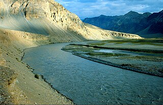
The Suru Valley is a valley in the Kargil District in the Union Territory of Ladakh, India. It is drained by the Suru River, a tributary of the Indus River. The valley's most significant town is Sankoo.

<span class="mw-page-title-main">Rangdum</span> Village in Ladakh, India

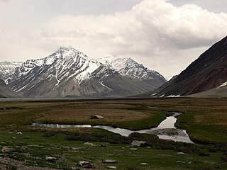
Rangdum is a village located in the Suru Valley in the union territory of Ladakh in Northern India. On one side are the colourful hills while on the other side are rocky mountains and glaciers, notably Drang-drung.

<span class="mw-page-title-main">Pensi La</span>

Pensi-la is a mountain pass in the Ladakh union territory of India, which is known as the Gateway to Zanskar. Pensi La is 4,400 metres (14,400 ft) above sea level and connects the Suru Valley region to the Zanskar Valley region. The summit at this end of the Suru Valley, the only peak which can be seen, is 7,012 metres (23,005 ft) high, while the mountain to the north is 6,873 metres (22,549 ft). The pass is about 25 km from Rangdum Monastery.

<span class="mw-page-title-main">Tourism in Ladakh</span>

Tourism is one of an economic contributor to the union territory of Ladakh in Northern India. The union territory is sandwiched between the Karakoram mountain range to the north and the Himalayas to the south and is situated at the height of 11,400 ft. Ladakh is composed of the Leh and Kargil districts. The region contains prominent Buddhist sites and has an ecotourism industry.

<span class="mw-page-title-main">Zanskar River</span> River in Ladakh, India

The Zanskar River is the first major tributary of the Indus River, equal or greater in volume than the main river, which flows entirely within Ladakh, India. It originates northeast of the Great Himalayan range and drains both the Himalayas and the Zanskar Range within the region of Zanskar. It flows northeast to join the Indus River near Nimo.

<span class="mw-page-title-main">Doda River</span> River in India

The Doda River or the Stod River is a river 79 kilometres (49 mi) long, which forms the Stod Valley in the Zanskar valley of the Leh district in the Union Territory of Ladakh in India.

<span class="mw-page-title-main">Karsha Monastery</span> Tibetan Buddhist monastery at Pensi-la, Ladakh, India

Karsha Monastery or Karsha Gompa is a Buddhist monastery in the Padum Valley of the Zanskar region of the union territory of Ladakh in northern India. The Doda River flows past the monastery from its source at the Drang Drung Glacier of the Pensi La. It was founded by the translator Phagspa Shesrab. The monastery, also known by the name Karsha Chamspaling, was founded by Phagspa Shesrab, under the Gelugpa Order or Yellow Hats. It is 11 km north of Padum in Zanskar River valley.

<span class="mw-page-title-main">Rangdum Monastery</span> Tibetan Buddhist monastery in Julidok, Ladakh, India

Rangdum Monastery is a Tibetan Buddhist monastery belonging to the Gelugpa sect, situated on top of a small but steep sugarloaf hill at an altitude of 4,031 m (13,225 ft) at the head of the Suru Valley, in Ladakh. It is next to the tiny village of Julidok (Zulidok), and about 25 km north of the 4,400 m (14,436 ft) Pensi La (pass), which leads into Zanskar. It is on Padum-Sankoo-Kargil Road, 103 km northwest of Padum, 87 km southeast of Sankoo & 196 southeast of Kargil. The monastery was electrified using solar energy in June 2017 by Global Himalayan Expedition (GHE)

Dzongkhul Monastery or Zongkhul Gompa is located 30 km northwest of Padum in the Stod Valley of Zanskar in Ladakh, northern India. Like the Sani Monastery, it belongs to the Drukpa school of Tibetan Buddhism

All Ladakh Gonpa Association (ALGA) is the central organisation of the Buddhist monasteries in Ladakh, India. It aims to preserve and strengthen the monastic institutions. It was founded by the 19th Kushok Bakula Rinpoche in 1949 and he acted as its president for 41 years, from 1949 until 1991. In 1949, the first meeting of the great monasteries was held and ten monasteries took part. All Ladakh Gonpa Association was registered in 1959 and is run by a governing body consisting of fifteen lama members belonging to all four major schools of Tibetan Buddhism. There are sixteen major monastic institutions with hundreds of monks in each monastery.

<span class="mw-page-title-main">Nimmu–Padum–Darcha road</span> Road in India

Nimmu–Padum–Darcha road (NPDR) or Zanskar Highway is a road between the Indian union territory of Ladakh and the state of Himachal Pradesh, passing through the region of Zanskar. It connects Nimmu in the Indus Valley to Padum, the capital of Zanskar, and to Darcha village in Lahul and Spiti. It provides an alternative to the Leh–Manali Highway in linking Ladakh with the rest of India. It was built by the Border Roads Organisation (BRO) of the Indian Army. The construction of road was completed in March 2024. The already completed Atal tunnel, and the proposed unidirectional-twin-tube total-4-lane Shingo La Tunnel, which is expected to be completed by 2025 will provide all weather connectivity and reduce the distance from Manali to Kargil by 522 km.

References

  1. 1 2 "Ladakh-based Buddhist association demands district status for Zanskar". India Today. 4 September 2019.
  2. 3,000 Demonstrate for Separate District in Sub-Zero Temperatures at Kargil, The Wire, 06/FEB/2020.
  3. Ladakh-based Buddhist association demands district status for Zanskar, India Today, September 4, 2019.
  4. Schettler, Margaret & Rolf (1981), p. 150.
  5. "Zaskar Range | mountains, Asia". Encyclopædia Britannica. Retrieved 20 September 2017.
  6. "Zanskar Population". Census India. Retrieved 13 September 2020.
  7. "Paddar Population". Census India. Retrieved 29 August 2020.
  8. Rizvi (1998), p. 253.
  9. Rizvi (1996), pp. 242–242.
  10. C-16 Population By Mother Tongue – Jammu & Kashmir (Report). Office of the Registrar General & Census Commissioner, India. Retrieved 29 October 2021.
  11. Rather, Ali Mohammad (September 1999), "Kargil: The Post-War Scenario", Journal of Peace Studies, 6 (5–6), International Center for Peace Studies, archived from the original on 1 December 2014
  12. Beek, Martijn van Pirie, Fernanda (2008). Modern Ladakh : anthropological perspectives on continuity and change. Brill. ISBN   978-90-04-16713-1. OCLC   896146052.{{cite book}}: CS1 maint: multiple names: authors list (link)
  13. "Zangskari". Script Source. Retrieved 25 August 2012.
  14. "The Response to Tourism in Ladakh". Cultural Survival Quarterly Magazine. March 1990.
  15. Singh, Archana (20 July 2021). "The toxic love for Ladakh is weighing heavy on its natural resources". Mongabay.
  16. "The housewife explorers who climbed the Himalayas". The Telegraph. 21 April 2008. Archived from the original on 26 April 2008.

Bibliography