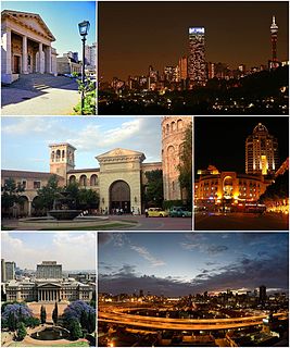
Johannesburg, informally known as Jozi, Joburg, or "The City of Gold", is the largest city in South Africa, classified as a megacity, and is one of the 100 largest urban areas in the world. According to Demographia, the Johannesburg-Pretoria urban area is the 26th-largest in the world, with 14,167,000 inhabitants. It is the provincial capital and largest city of Gauteng, which is the wealthiest province in South Africa. Johannesburg is the seat of the Constitutional Court, the highest court in South Africa. Most of the major South African companies and banks have their head offices in Johannesburg. The city is located in the mineral-rich Witwatersrand range of hills and is the centre of large-scale gold and diamond trade. It was one of the host cities of the official tournament of the 2010 FIFA World Cup – and it hosted the final.
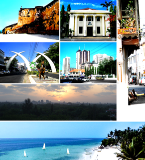
Mombasa is a coastal city in southeastern Kenya along the Indian Ocean. The city is known as the white and blue city in Kenya. It is the country's oldest and second-largest city, with a population of about 1,208,333 people according to the 2019 census. Its metropolitan region is the second-largest in the country, and has a population of 3,528,940 people.

Selebi-Phikwe is a mining town located in the Central District of Botswana. It had a population of 49,724 in 2011 which is now estimated to have risen to c.52,000. The town is an administrative district, separate from the surrounding Central District.

Klerksdorp is located in the North West Province, South Africa. Klerksdorp used to be the largest city in the North West Province located south-easterly to Mahikeng. Klerksdorp was also the first capital of the then Transvaal Republic and used to be the home of the first Stock Exchange in the region. It became an important trading town linking Kimberley to Johannesburg. It became home to a mix of farmers, miners and immigrants servicing the two industries.

Brits is a town situated in a fertile citrus, vegetable and grain-producing area that is irrigated by the waters of the Hartbeespoort Dam in North West Province of South Africa. It is close to the City of Tshwane Metropolitan Municipality in Gauteng, which includes Pretoria, and it has the same dialling code as Pretoria. In addition to being a centre for agriculture, the city is home to several heavy industries. A factory of the Italian car manufacturer Alfa Romeo produced cars for the domestic market and export to Asia from 1974 to 1985. The city also plays an important role in the South African mining industry: 94% of South Africa's platinum comes from the Rustenburg and Brits districts, which together produce more platinum than any other single area in the world. In addition, there is a large vanadium mine in the district.

Springs is a former independent city, on the East Rand, now part of the Ekurhuleni in the Gauteng province of South Africa. It lies 50 km (31 mi) east of Johannesburg and 72 km (45 mi) southeast from Pretoria. The name of Springs derives from the large number of springs in the area; it has an estimated population of more than 121,610 in 2011 and is situated at 1628 m (5,340 ft) a.s.l.

Rondebosch is one of the Southern Suburbs of Cape Town, South Africa. It is primarily a residential suburb, with shopping and business districts as well as the main campus of the University of Cape Town.

Isipingo is a town situated 19 kilometres (12 mi) south of Durban in KwaZulu-Natal, South Africa. Under apartheid it was first a "whites only" area, but was then reclassified as Indian. By forcing the whites to sell their houses and move out, the apartheid government claimed it was being fair, as it wished to justify the forcing out of millions of people who were not white from their homes around South Africa. Isipingo currently forms part of eThekwini Metropolitan Municipality. The town is named after the Siphingo River, which in turn is thought to be named for the intertwining cat-thorn shrubs (Scutia myrtina) present in the area, or the river's winding course. The town comprises Isipingo Rail, Malaba Hills, Isipingo Hills, Lotus Park, Orient Hills, Malukazi and Isipingo Beach, a seaside township built on a high ridge of sand at the mouth of the Siphingo River.

Wesselsbron is a small maize farming town 75 kilometres south of Bothaville in Free State province of South Africa.

Lichtenburg is a town situated in North West Province of South Africa. It is the administrative centre of Ditsobotla Local Municipality.
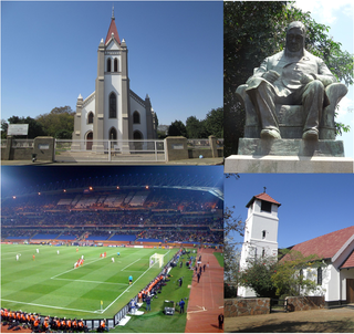
Rustenburg is a city at the foot of the Magaliesberg mountain range. Rustenburg is the most populous city in North West province, South Africa. In 2017, the city's Gross Domestic Product (GDP) reached ZAR 63.8 billion, accounting for 21.1% of the GDP of the North West Province, and 1.28% of the GDP of South Africa. Rustenburg was one of the official host cities of the 2010 FIFA World Cup, being in close proximity to Phokeng, the capital of the Royal Bafokeng Nation, where the Royal Bafokeng Stadium is located. The England national football team also used this as their base camp for the tournament.

Strand is a seaside resort town in the Western Cape, South Africa. It forms part of the Helderberg region of the City of Cape Town Metropolitan Municipality, situated on the north-eastern edge of False Bay and near the foot of the Helderberg Mountains. Its geographical position is between Somerset West and Gordon's Bay, and is about 50 km southeast of Cape Town City Bowl. Strand is in the Western Cape province of South Africa, and has a population of approximately 50,000. Strand's main attraction is the beach; 5 km of white sandy beach off False Bay.

Umlazi is a township in KwaZulu-Natal, South Africa, located south-west of Durban. It is the fourth largest township in South Africa, after Soweto, Tembisa and Katlehong. Umlazi is the only township in the country that has its own registration plate, which is NUZ. It is divided into 26 sections, A through to Z, with the exception of I, O and X, but with an addition of AA, BB and CC.

Saket is a residential colony and the administrative headquarters of the South Delhi district of Delhi in India. The neighborhood is named after the city of Ayodhya, also known as Saket, an ancient, religiously significant city in Uttar Pradesh. Saket has four major malls on the Press Enclave Marg.

Salt River is a suburb of Cape Town, located near Table Bay, to the east of Cape Town's central business district. Salt River is served by a railway station of the same name, and has the postcode 7925. It is noted for its association with the clothing and textiles industry. The name Salt River is a translation of the Dutch "Soutrivier".

Nkayi is a district in Matabeleland North, Zimbabwe, about 100 km (62 mi) west of Kwekwe and 168 km (104 mi) northeast of Bulawayo in Nkayi communal land. It is believed that its name originates from the Tonga word "Uyinkayi" meaning "where are you going". The main language spoken is Ndebele.

Al Karama, or simply Karama, is a residential district of Dubai located on the western banks of the Dubai Creek and one of the older communities of the city. It is outwardly distinctive due to the regularity of its low-rise residential buildings. The area, which was planned on a tight grid system, is home to thousands of people even though it is only two square kilometers in size. Al Karama is the most populous residential area in Dubai and the most central part of Dubai. Al Karama is also one of the most accessible parts in Dubai, that makes it very easy for residents to travel to any other parts of the city from Karama with ease due to the wide range of transport available in the town.

Palavakam is a locality in the south of Chennai and census town in Chennai district in the Indian state of Tamil Nadu. It is located on the East Coast Road about 6 km south of Adyar.
Phoenix is a South African town about 25 kilometres northwest of Durban Central, in KwaZulu-Natal, South Africa. It was established as a town by the apartheid government in 1976, but it has a long history of Indian occupation. It is associated with the Phoenix Settlement, built by Mahatma Gandhi.
The Kluang, formerly Keluang, is a town in Kluang District, Johor, Malaysia. Kluang was founded in 1915 as the administrative capital of central Johor by the British. It is located in the centre of the state and is within 90 minutes of all major urban areas of Johor. Kluang, combined with Batu Pahat, encompasses central Johor with a market catchment of over 700,000. Over the 20th century, Kluang's economy transitioned from rubber to palm oil and now has some of Malaysia's largest organic farms. The industrial sector has also grown significantly with multinational investment and a critical mass of tile manufacturers enabling the district to be called the 'tile capital of Malaysia'. The organic farming sector has also boosted Kluang as an ecotourism destination with key farms such as Zenxin, UK Agro and Kahang Organic Rice Farm.


