Megathrust earthquakes occur at convergent plate boundaries, where one tectonic plate is forced underneath another. The earthquakes are caused by slip along the thrust fault that forms the contact between the two plates. These interplate earthquakes are the planet's most powerful, with moment magnitudes (Mw) that can exceed 9.0. Since 1900, all earthquakes of magnitude 9.0 or greater have been megathrust earthquakes.

Many major earthquakes have occurred in the region of the Kamchatka Peninsula in far eastern Russia. Events in 1737, 1923 and 1952, were megathrust earthquakes and caused tsunamis. There are many more earthquakes and tsunamis originating from the region.
The 1905 Kangra earthquake occurred in the Kangra Valley and the Kangra region of the Punjab Province in India on 4 April 1905. The earthquake measured 7.8 on the surface wave magnitude scale and killed more than 20,000 people. Apart from this, most buildings in the towns of Kangra, Mcleodganj and Dharamshala were destroyed.

The 2016 Ecuador earthquake occurred on April 16 at with a moment magnitude of 7.8 and a maximum Mercalli intensity of VIII (Severe). The very large thrust earthquake was centered approximately 27 km (17 mi) from the towns of Muisne and Pedernales in a sparsely populated part of the country, and 170 km (110 mi) from the capital Quito, where it was felt strongly. Regions of Manta, Pedernales and Portoviejo accounted for over 75 percent of total casualties. Manta's central commercial shopping district, Tarqui, was completely destroyed. Widespread damage was caused across Manabí Province, with structures hundreds of kilometres from the epicenter collapsing. At least 676 people were killed and 16,600 people injured. President Rafael Correa declared a state of emergency; 13,500 military personnel and police officers were dispatched for recovery operations.
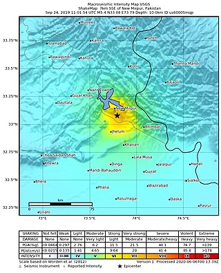
The 2019 Kashmir earthquake struck regions of Pakistan with an epicentre in Azad Kashmir on 24 September at 16:02 local time. It had a magnitude of 5.4 and a maximum felt intensity of VII on the Modified Mercalli intensity scale or VIII on the European macroseismic scale. There was severe damage in Mirpur District, causing the deaths of 40 people and injuring a further 850. The epicentre of the shallow quake was near the city of Mirpur, Pakistan. The tremors were felt in the Kashmir region, Punjab (Pakistan), Punjab (India), Uttarakhand and northern parts of India including New Delhi.
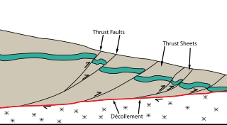
The Main Himalayan Thrust (MHT) is a décollement under the Himalaya Range. This thrust fault follows a NW-SE strike, reminiscent of an arc, and gently dips about 10 degrees towards the north, beneath the region. It is the largest active continental megathrust fault in the world.

The Main Frontal Thrust (MFT), also known as the Himalayan Frontal Thrust (HFT), is a geological fault in the Himalayas that defines the boundary between the Himalayan foothills and Indo-Gangetic Plain. The fault is well expressed on the surface thus could be seen via satellite imagery. It is the youngest and southernmost thrust structure in the Himalaya deformation front. It is a splay branch of the Main Himalayan Thrust (MHT) as the root décollement.
The 1833 Nepal–India earthquake occurred on August 26 at 22:58 local time (NPT). This earthquake had an estimated moment magnitude of 7.6–7.9 and struck with an epicenter somewhere in or near the Kathmandu Valley. The earthquake caused major destruction in numerous towns and villages in Nepal, northern India, and Tibet. The earthquake was also felt in Chittagong, Bangladesh. Despite the extent of the damage, the number of fatalities resulting from the earthquake was surprisingly low, at approximately 500. This was because the mainshock was preceded by two smaller but intense foreshocks earlier that day, causing many residents to take refuge outside their homes.
The 1906 Manasi earthquake (玛纳斯地震), also known as the Manas earthquake occurred in the morning of December 23, 1906, at 02:21 UTC+8:00 local time or December 22, 18:21 UTC. It measured 8.0–8.3 on the moment magnitude scale and 8.3 on the surface-wave magnitude scale. The epicenter of this earthquake is located in Manas County, Xinjiang, China. An estimated 280–300 people died and another 1,000 more were injured by the earthquake.
The Nemuro-Oki earthquake in scientific literature, occurred on June 17 at 12:55 local time. It struck with an epicenter just off the Nemuro Peninsula in northern Hokkaidō, Japan. It measured 7.8–7.9 on the moment magnitude scale (Mw ), 8.1 on the tsunami magnitude scale (Mt ) and 7.4 on the Japan Meteorological Agency magnitude scale (MJMA ).
The 2021 Assam earthquake struck 11 km away from Dhekiajuli, Assam, India at 07:51 (IST) on April 28, 2021 with a moment magnitude of 6.0 at 34.0 km (21.1 mi) depth. The quake struck with an epicenter 140 km north of the main city of Guwahati. It resulted in two fatalities and at least 12 injuries.
The 1555 Kashmir earthquake occurred at around midnight in the month of Ashvin in the Hindu calendar, or September in the Gregorian calendar, although the exact day of occurrence is not known. The earthquake seriously impacted the Kashmir Valley in present-day Pakistan and northwestern India. A moment magnitude (Mw ) of 7.6 to 8.0 and Modified Mercalli intensity of XII (Extreme) has been estimated for the earthquake. Thought to be one of the most destructive in the Kashmir Valley, the earthquake caused serious widespread damage and ground effects, killing an estimated 600–60,000 individuals.
The 1889 Chilik earthquake occurred on July 11 on the Gregorian calendar, or June 30 on the Julian calendar at 15:14 local time in the Tien Shan mountains. The earthquake measured an estimated Mw 7.9–8.0 on the moment magnitude scale and was assigned a maximum intensity of X (Devastating) on the MSK 64 and Rossi-Forel scales. Over 92 people across Kazakhstan, Kyrgyzstan and China were killed.
The 1716 Algiers earthquake was part of a seismic sequence which began in February and ended in May 1716. The largest and most destructive shock occurred on February 3 with an estimated moment magnitude of 7.0. The earthquakes with an epicenter thought to be in the Algiers region had a maximum European macroseismic scale (EMS-98) intensity of IX (Destructive), killing approximately 20,000 people. The earthquake was felt in Catania and Syracuse on the Italian island Sicily.
The 1654 Tianshui earthquake occurred on July 21 in Tianshui, Gansu Province, Ming dynasty sometime between 21:00 and 23:00 local time. The event had an estimated moment magnitude of 7.0 and was assigned a maximum intensity of XI on the China seismic intensity scale. Resulting in extreme damage and affecting at least four provinces, the quake killed approximately 30,000 people.
The 1885 Kashmir earthquake, also known as the Baramulla earthquake occurred on 30 May in Srinagar. It had an estimated moment magnitude of Mw 6.3–6.8 and maximum Medvedev–Sponheuer–Karnik scale intensity of VIII (Damaging). At least 3,081 people died and severe damage resulted.
The 1803 Garhwal earthquake occurred in the early morning of September 1 at 01:30 local time. The estimated 7.8-magnitude-earthquake had an epicenter in the Garhwal Himalaya near Uttarkashi, British India. Major damage occurred in the Himalaya and Indo-Gangetic Plain, with the loss of between 200 and 300 lives. It is among the largest Himalaya earthquakes of the 19th-century, caused by thrust faulting.
The 1980 Nepal earthquake devastated the Nepal–India border region on the evening of July 29. The epicenter of the 6.6 earthquake was located in Nepal, northwest of Khaptad National Park. At least 200 people died and 5,600 were injured in the disaster. Extensive damage occurred on both sides of the border, amounting to 245 million USD.
On December 5, 1456, the largest earthquake to occur on the Italian Peninsula struck the Kingdom of Naples. The earthquake had an estimated moment magnitude of Mw 7.19–7.4, and was centred near the town of Pontelandolfo in the present-day Province of Benevento, southern Italy. Earning a level of XI (Extreme) on the Modified Mercalli intensity scale, the earthquake caused widespread destruction in central and southern Italy. An estimated 30,000–70,000 people were killed. It was followed by two strong Mw 7.0 and 6.0 earthquakes to the north on December 30.

The 1902 Shamakhi earthquake occurred on 13 February with a surface-wave magnitude of 6.9 and a maximum felt Modified Mercalli intensity of IX (Violent). Up to 2,000 people died and thousands more were injured in the Shemakha uezd within the Baku Governorate of the Russian Empire. About 7,439 buildings were damaged or destroyed in the city and surrounding villages. Shamakhi had been devastated by earlier earthquakes in 1806, 1859 and 1872. It is one of the most destructive earthquakes in Azerbaijan.

