
Central America is a subregion of the Americas, frequently considered part of North America. Its political boundaries are defined as bordering Mexico to the north, Colombia to the south, the Caribbean Sea to the east, and the Pacific Ocean to the west. Central America usually consists of seven countries: Belize, Costa Rica, El Salvador, Guatemala, Honduras, Nicaragua, and Panama. Within Central America is the Mesoamerican biodiversity hotspot, which extends from northern Guatemala to central Panama. Due to the presence of several active geologic faults and the Central America Volcanic Arc, there is a high amount of seismic activity in the region, such as volcanic eruptions and earthquakes, which has resulted in death, injury, and property damage.
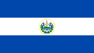
El Salvador, officially the Republic of El Salvador, is a country in Central America. It is bordered on the northeast by Honduras, on the northwest by Guatemala, and on the south by the Pacific Ocean. El Salvador's capital and largest city is San Salvador. The country's population in 2023 was estimated to be 6.5 million.

El Salvador is a country in Central America. Situated at the meeting point of three tectonic plates, it is highly seismologically active and the location of numerous earthquakes and volcanic eruptions. The country has a tropical climate.

Guatemala City, formally New Guatemala of Assumption and the Ancient, known locally as Guate, is the capital and largest city of Guatemala, and the most populous urban area in Central America. The city is located in the south-central part of the country, nestled in a mountain valley called Valle de la Ermita. The city is also the capital of the Guatemala Department.

San Salvador is the capital and the largest city of El Salvador and its eponymous department. It is the country's political, cultural, educational and financial center. The Metropolitan Area of San Salvador, which comprises the capital itself and 13 of its municipalities, has a population of 2,404,097. The urban area of San Salvador has a population of 1,600,000 inhabitants.

Guatemala is mountainous, except for the south coastal area and the vast northern lowlands of Petén department. The country is located in Central America and bounded to the north and west by Mexico, to the east by Belize and by the Gulf of Honduras, to the east by Honduras, to the southeast by El Salvador, and to the south by the Pacific Ocean. Two mountain chains enter Guatemala from west to east, dividing the country into three major regions: the highlands, where the mountains are located; the Pacific coast, south of the mountains; and the limestone plateau of the Petén region, north of the mountains. These areas vary in climate, elevation, and landscape, providing dramatic contrasts between hot and humid tropical lowlands and highland peaks and valleys.

Antigua Guatemala, commonly known as Antigua or La Antigua, is a city in the central highlands of Guatemala. The city was the capital of the Captaincy General of Guatemala from 1543 through 1773, with much of its Baroque-influenced architecture and layout dating from that period. These characteristics had it designated as a UNESCO World Heritage Site in 1979. Antigua Guatemala serves as the capital of the homonymous municipality and the Sacatepéquez Department.
San Martín Jilotepeque is a town, with a population of 10,812, and a municipality in the Chimaltenango department of Guatemala. It was the site of a bus accident in 2013.

The Captaincy General of Guatemala, also known as the Kingdom of Guatemala, was an administrative division of the Spanish Empire, under the viceroyalty of New Spain in Central America, including the present-day nations of Costa Rica, Nicaragua, Honduras, El Salvador, and Guatemala, and the Mexican state of Chiapas. The governor-captain general was also president of the Royal Audiencia of Guatemala, the superior court.

San Andrés is a pre-Columbian site in El Salvador, whose occupation began around the year 900 BC as an agricultural town in the valley of Zapotitán in the department of La Libertad. This early establishment was vacated by the year 250 because of the enormous eruption of the caldera of Lago Ilopango, and was occupied again in the 5th Century, along with many other sites in the valley of Zapotitán. Between 600 and 900 AD, San Andrés was the capital of a Maya polity with supremacy over the other establishments of Valle de Zapotitán.
The January 2001 El Salvador earthquake struck El Salvador on January 13, 2001, at 17:33:34 UTC. The 7.6 quake struck with the epicenter 60 miles (100 km) SW of San Miguel, El Salvador at a depth of 60 km.
The 1902 Guatemala earthquake occurred on April 18 at 8:23 pm with a moment magnitude of 7.5 and a maximum Mercalli intensity of VIII (Severe). The rupture was initiated at a depth of 25 km (16 mi) and the duration was 1 to 2 minutes.
El Salvador – sovereign country located on the Pacific Coast of Central America. The area was originally called by the Pipil "Cuzcatan", in Spanish "Cuzcatlan", which in Nahuat means "The Land Of Precious Things". After the Spanish conquest, the land was divided into the province of San Salvador and the province of Izalcos ; until in 1824 the two jurisdictions were united in the State, now Republic, of El Salvador. The country borders the Pacific Ocean between Guatemala and Honduras. With a population of approximately 5.8 million people, it is the most densely populated nation in Central America and is undergoing rapid industrialization.
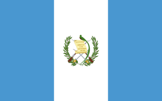
Guatemala, officially the Republic of Guatemala, is a country in Central America. It is bordered to the north and west by Mexico, to the northeast by Belize, to the east by Honduras, and to the southeast by El Salvador. It is touched to the south by the Pacific Ocean and to the northeast by the Gulf of Honduras. With an estimated population of around 17.6 million, Guatemala is the most populous country in Central America, the 4th most populous country in North America and the 11th most populous country in the Americas. It is a representative democracy with its capital and largest city being Nueva Guatemala de la Asunción, also known as Guatemala City, the most populous city in Central America.

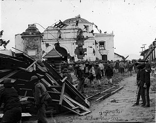
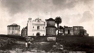
The 1773 Guatemala earthquake struck colonial Guatemala on July 29 at 15:45 local time. It had an estimated epicentral magnitude of 7.5 Mi. It was part of a sequence that started in May that year. There were two strong foreshocks on June 11 and the mainshock was followed by numerous aftershocks which lasted until December 1773. The series of all these earthquakes is also referred to as the Santa Marta earthquake(s) as it had started on the feast day of Saint Martha.

The Holy Church Cathedral Metropolitan Basilica of Santiago de Guatemala also Metropolitan Cathedral, officially Catedral Primada Metropolitana de Santiago, is the main church of Guatemala City and of the Archdiocese of Guatemala. It is located at the Parque Central in the center of the city. Its massive structure incorporates baroque and classical elements and has withstood numerous earthquakes. Damage by the devastating earthquakes of 1917 and 1976 has been repaired. The inside of the cathedral is relatively sparsely decorated but impresses by its size and its structural strength. The altars are ornate and decorative. In front of the cathedral stand a series of 12 pillars, solemnly remembering the names of thousands of people forcibly disappeared or murdered during the counterinsurgency violence of Guatemala's internal armed conflict, which began in 1960 and lasted until the final peace accord was signed in 1996.

Santiago de los Caballeros de Guatemala was the name given to the capital city of the Spanish colonial Captaincy General of Guatemala in Central America.
Human settlement on the present site of Guatemala City began with the Maya who built a city at Kaminaljuyu. The Spanish colonists established a small town, which was made a capital city in 1775. At this period the Central Square with the Cathedral and Royal Palace were constructed. After Central American independence from Spain the city became the capital of the United Provinces of Central America in 1821.

The Spanish conquest of El Salvador was the campaign undertaken by the Spanish conquistadores against the Late Postclassic Mesoamerican polities in the territory that is now incorporated into the modern Central American country of El Salvador. El Salvador is the smallest country in Central America, and is dominated by two mountain ranges running east–west. Its climate is tropical, and the year is divided into wet and dry seasons. Before the conquest the country formed a part of the Mesoamerican cultural region, and was inhabited by a number of indigenous peoples, including the Pipil, the Lenca, the Xinca, and Maya. Native weaponry consisted of spears, bows and arrows, and wooden swords with inset stone blades; they wore padded cotton armour.
An earthquake occurred on 26 August 2012 at 22:37 local time. The earthquake located off the coast of El Salvador measured 7.3 on the moment magnitude scale and had a focal depth of 16.0 kilometres (10 mi). No deaths were reported, however more than 40 people were injured when they were caught in a tsunami generated by the earthquake. Waves from the tsunami were unusually large for an earthquake of this size. The large waves were attributed to the earthquake's unique rupture characteristic. In addition to the absence of fatalities, damage caused by the earthquake and tsunami was minimal as a result of the sparse population around the affected region and the slow rupture characteristic of the event.
