
Thomaston is a town in Litchfield County, Connecticut, United States. The town is part of the Naugatuck Valley Planning Region. The population was 7,442 at the 2020 census. The urban center of the town is the Thomaston census-designated place, with a population of 1,928 at the 2020 census.

Beacon Falls is a town in western New Haven County, Connecticut, United States. The town is part of the Naugatuck Valley Planning Region. It lies in the southwestern part of the state, and is bisected by the Naugatuck River. The population was 6,000 at the 2020 census, down from 6,049 at the 2010 census.
Prospect is a town in the Naugatuck Valley Planning Region, Connecticut, United States. It is a suburb of the nearby city of Waterbury to its north, and is on the north-eastern fringes of the New York metropolitan area. The population was estimated to be 9,401 in 2020. Prospect is part of the Waterbury NECTA and of the historical New Haven County. Prospect is also a member of the regional health district Chesprocott, along with Cheshire and Wolcott.

Wolcott is a town in New Haven County, Connecticut, United States. The town is part of the Naugatuck Valley Planning Region. It is primarily residential, with a population of 16,142 as of the 2020 United States Census.

Naugatuck is a consolidated borough and town in New Haven County, Connecticut, United States. The town, part of the Naugatuck Valley Planning Region, had a population of 31,519 as of the 2020 Census.

Waterbury is a city in the U.S. state of Connecticut. Waterbury had a population of 114,403 as of the 2020 Census. The city is 33 miles (53 km) southwest of Hartford and 77 miles (124 km) northeast of New York City. Waterbury is the largest city in the Naugatuck Valley Planning Region and second-largest city in New Haven County.

Hurricane Connie was a Category 4 hurricane that contributed to significant flooding across the eastern United States in August 1955, just days before Hurricane Diane affected the same general area. Connie formed on August 3 from a tropical wave in the eastern Atlantic Ocean. It moved quickly west-northwestward, strengthening into a hurricane by August 4. Connie first posed a threat to the Lesser Antilles, ultimately passing about 105 mi (169 km) north of the island group. In the United States Virgin Islands, three people died due to the hurricane, and a few homes were destroyed. The outer rainbands produced hurricane-force wind gusts and intense precipitation, reaching 8.65 in (220 mm) in Puerto Rico. On the island, Connie destroyed 60 homes and caused crop damage. After affecting Puerto Rico, Connie reached maximum sustained winds of 140 mph (230 km/h), and a barometric pressure of 944 mbar (27.9 inHg), as observed by the Hurricane Hunters on August 7. The hurricane later weakened, slowed its forward motion, and turned to the north, striking North Carolina on August 12 as a Category 2 on the Saffir-Simpson scale. Connie was the first of three damaging tropical cyclones in the 1955 hurricane season to hit the state, along with Diane and Ione. The storm progressed inland after moving through the Chesapeake Bay region, and was later absorbed by a cold front over Lake Huron on August 15.

Hurricane Diane was the first Atlantic hurricane to cause more than an estimated $1 billion in damage, including direct costs and the loss of business and personal revenue. It formed on August 7 from a tropical wave between the Lesser Antilles and Cape Verde. Diane initially moved west-northwestward with little change in its intensity, but began to strengthen rapidly after turning to the north-northeast. On August 12, the hurricane reached peak sustained winds of 105 mph (165 km/h), making it a Category 2 hurricane. Gradually weakening after veering back west, Diane made landfall near Wilmington, North Carolina, as a strong tropical storm on August 17, just five days after Hurricane Connie struck near the same area. Diane weakened further after moving inland, at which point the United States Weather Bureau noted a decreased threat of further destruction. The storm turned to the northeast, and warm waters from the Atlantic Ocean helped produce record rainfall across the northeastern United States. On August 19, Diane emerged into the Atlantic Ocean southeast of New York City, becoming extratropical two days later and completely dissipating by August 23.

The Naugatuck Railroad is a common carrier railroad owned by the Railroad Museum of New England and operated on tracks leased from the Connecticut Department of Transportation. The original Naugatuck Railroad was a railroad chartered to operate through south central Connecticut in 1845, with the first section opening for service in 1849. In 1887 the line was leased by the New York, New Haven and Hartford Railroad, and became wholly owned by 1906. At its greatest extent the Naugatuck ran from Bridgeport north to Winsted. Today's Naugatuck Railroad, formed in 1996, runs from Waterbury to the end of track in Torrington, Connecticut. From Waterbury south to the New Haven Line, Metro-North Railroad operates commuter service on the Waterbury Branch.

The Waterbury Branch is a branch of the Metro-North Railroad's New Haven Line, running north from a junction in the Devon section of Milford to Waterbury, Connecticut. Originally built as the Naugatuck Railroad, it once continued north to Winsted. The part north of Waterbury is now leased from CDOT by the Railroad Museum of New England, which operates excursion trains from Thomaston station through their operating subsidiary Naugatuck Railroad ; this name was chosen in homage of the original railroad. The trackage ends in Torrington, but Metro-North service on the branch ends at Waterbury. There are conceptual plans to extend service from its current terminus in Waterbury to Hartford via Bristol and New Britain. Currently, riders that want to continue to New Britain and Hartford have to transfer to an express bus operated by CTtransit at Waterbury. All trains on this branch operate as shuttles between Waterbury and Bridgeport.

Connecticut's 5th congressional district is a congressional district in the U.S. state of Connecticut. Located in the western part of the state and spanning across parts of Fairfield, Litchfield, New Haven, and Hartford Counties, the district runs from Meriden and New Britain in central Connecticut, westward to Danbury and the surrounding Housatonic Valley, encompassing the Farmington Valley, Upper Naugatuck River Valley, and the Litchfield Hills. The district also includes most of Waterbury.

The Naugatuck River is a 40.2-mile-long (64.7 km) river in the U.S. state of Connecticut. Its waters carve out the Naugatuck River Valley in the western reaches of the state, flowing generally due south and eventually emptying into the Housatonic River at Derby, Connecticut and thence 11 miles (18 km) to Long Island Sound. The Plume and Atwood Dam in Thomaston, completed in 1960 following the Great Flood of 1955, creates a reservoir on the river and is the last barrier to salmon and trout migrating up from the sea.

The Connecticut Company was the primary electric street railway company in the U.S. state of Connecticut, operating both city and rural trolleys and freight service. It was controlled by the New York, New Haven and Hartford Railroad, which also controlled most steam railroads in the state. After 1936, when one of its major leases was dissolved, it continued operating streetcars and, increasingly, buses in certain Connecticut cities until 1976, when its assets were purchased by the state government.

Mattatuck State Forest is a Connecticut state forest spread over twenty parcels in the towns of Waterbury, Plymouth, Thomaston, Watertown, Litchfield, and Harwinton. The Naugatuck River runs through a portion of the forest. The largest section of the forest is located about 1 mile (1.6 km) north of Waterbury. The Leatherman's Cave, named after the vagabond Leatherman of the late 19th century, is located in Thomaston near the Mattatuck Trail, 1/4 mile west of the junction with the Jericho Trail.
Waterville is a neighborhood of the city of Waterbury, Connecticut. It was formerly known as Pine Hole and Haydensville. It has been home to industrial and manufacturing facilities from the 1960s onward. The ethnic makeup of Waterville consists of Italian, Irish, French and Latin American. This section of Waterbury contains two parks and the main office of the city's Department of Transportation.

Route 262 is a state highway in west central Connecticut running in a "U" pattern from Watertown to Plymouth.
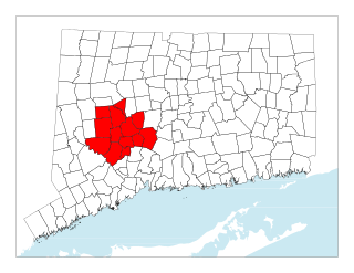
The Central Naugatuck Valley is a region of Connecticut in New Haven and Litchfield counties located approximately 70 miles (110 km) northeast of New York City and 110 miles (180 km) southwest of Boston, United States. The region comprises 13 towns: Beacon Falls, Bethlehem, Cheshire, Middlebury, Naugatuck, Oxford, Prospect, Southbury, Thomaston, Waterbury, Watertown, Wolcott, and Woodbury.

The Whitestone Cliffs Trail is a 1.7-mile (2.7 km) Blue-Blazed hiking trail in the Waterbury area in Thomaston and Plymouth, Litchfield County, Connecticut. It is contained almost entirely in a section of the Mattatuck State Forest. The mainline trail is a loop trail with one connector trail to the Jericho Blue-Blazed Trail.

The Mad River is a river that flows through northern New Haven County, Connecticut, in the United States.
