
Nagasaki Prefecture is a prefecture of Japan located on the island of Kyūshū. Nagasaki Prefecture has a population of 1,314,078 and has a geographic area of 4,130 km2. Nagasaki Prefecture borders Saga Prefecture to the northeast.
Isahaya is a city located in Nagasaki Prefecture, Japan. The city was founded on September 1, 1940. As of November 1, 2022, the city has an estimated population of 132,385 and a population density of 389 persons per km². The total area is 341.79 km2 (131.97 sq mi).

Mount Unzen is an active volcanic group of several overlapping stratovolcanoes, near the city of Shimabara, Nagasaki on the island of Kyushu, Japan's southernmost main island.

Isahaya Station is a railway station in Eishō-chō, Isahaya, Nagasaki, Japan. It is owned by Kyushu Railway Company, and is the junction between three lines: the Nagasaki Main Line, Ōmura Line and the private Shimabara Railway Line.

Typhoon Nabi, known in the Philippines as Typhoon Jolina, was a powerful typhoon that struck southwestern Japan in September 2005. The 14th named storm of the 2005 Pacific typhoon season, Nabi formed on August 29 to the east of the Northern Mariana Islands. It moved westward and passed about 55 km (34 mi) north of Saipan on August 31 as an intensifying typhoon. On the next day, the Joint Typhoon Warning Center upgraded the storm to super typhoon status, with winds equivalent to that of a Category 5 hurricane on the Saffir–Simpson Hurricane Scale. The Japan Meteorological Agency estimated peak ten-minute winds of 175 km/h (109 mph) on September 2. Nabi weakened while curving to the north, striking the Japanese island of Kyushu on September 6. After brushing South Korea, the storm turned to the northeast, passing over Hokkaido before becoming extratropical on September 8, before dissipating on September 12.
The 1953 North Kyushu flood was a flood which hit Northern Kyushu, Japan in June 1953. The flood was caused by cloudbursts and prolonged rain from the Meiyu rain front which dropped 1,000 mm of rain over Mount Aso and Mount Hiko. This downpour resulted in the overflow of many of the surrounding rivers, such as the Chikugo River.

Typhoon Bart, known in the Philippines as Typhoon Oniang, was a powerful and destructive typhoon that occurred during the 1999 Pacific typhoon season. It was the only super typhoon of that year. Bart reached "super typhoon" status on September 22, when it grew to comprise winds containing a force of 260 km/h (160 mph).

Typhoon Kathleen was a typhoon that approached Japan in September 1947. Kathleen brought record heavy rain at the time, causing major destruction in the Kanto region.
Japan is the country that is most affected by natural disasters mainly due to it being in the Ring of Fire. Two out of the five most expensive natural disasters in recent history have occurred in Japan, in 1995 and 2011, costing $181 billion. Japan has also been the site of some of the 10 worst natural disasters of the 21st century. Many types of natural disasters occur in Japan such as tsunamis, floods, typhoons, earthquakes, cyclones, and even volcanic eruptions. The country has gone through thousands of years of natural disasters, affecting its economy, development, and social life. Some other major disasters in Japan were more recent, such as the January 1995 Great Hanshin earthquake and the March 2011 Tōhoku earthquake and tsunami, which triggered the Fukushima Daiichi nuclear disaster.

Typhoon Ma-on, known in the Philippines as Typhoon Rolly, was a powerful typhoon that produced record breaking wind gusts across the Tokyo Metropolitan Area during October 2004. The twenty-second named storm of the 2004 Pacific typhoon season, Ma-on was the second of three consecutive storms to hit Japan during the period between late-September to mid-October 2004.

On 20 August 2014, Hiroshima Prefecture in Japan was struck by a series of landslides following heavy rain. The rain triggered 166 slope failures which included 107 debris flows and 59 shallow slides. The landslides hit residential areas including Kabe, Asakita Ward, Yagi, Yamamoto, Midorii, and Asaminami Ward. Of these areas, the Asakita and Asaminami Wards in Northern Hiroshima were hit the hardest.

Typhoon Della, known in Japan as the 3rd Miyakojima Typhoon and in the Philippines as Typhoon Maring, was a typhoon that struck Miyakojima of Ryukyu Islands and Kyūshū Island in September 1968.

In late June through mid-July 2018, successive heavy downpours in southwestern Japan resulted in widespread, devastating floods and mudflows. The event is officially referred to as Heisei san-jū-nen shichi-gatsu gōu by the Japan Meteorological Agency. As of 20 July, 225 people were confirmed dead across 15 prefectures with a further 13 people reported missing. More than 8 million people were advised or urged to evacuate across 23 prefectures. It is the deadliest freshwater flood-related disaster in the country since the 1982 Nagasaki flood when 299 people died.

Typhoon Talim, known in the Philippines as Typhoon Lannie, was an intense and destructive tropical cyclone that affected parts of East Asia, especially Japan, during September 2017. The eighteenth named storm and the sixth typhoon of the 2017 Pacific typhoon season, Talim's origins can be traced back to an area of low-pressure that the Joint Typhoon Warning Center first monitored on September 6. The disturbance was upgraded to a tropical depression by the Japan Meteorological Agency only two days later, and it became a tropical storm on September 9, earning the name Talim. Talim grew stronger over the next few days, eventually becoming a typhoon the next day. Within a favorable environment, the typhoon rapidly intensified after passing through the Ryukyu Islands. However, as it moved eastward, Talim started to weaken due to wind shear, and on September 16, it was downgraded to a tropical storm. The storm passed over Japan, near Kyushu the next day, before becoming extratropical on September 18. The extratropical remnants were last noted by the JMA four days later, before dissipating fully on September 22.

Typhoon Dinah was a tropical cyclone that brought heavy damages to Japan, while leaving 65 fatalities and 70 to be missing, all in that country alone. It is also one of the disasters that happened in the country during the Showa 27 era. The second typhoon of the 1952 Pacific typhoon season, Dinah was first mentioned in weather maps as a tropical depression to the east of Visayas. It gradually organized, becoming a tropical storm on June 21 as it skirted the northeastern Philippines, with the Fleet Weather Center naming it Dinah. It strengthened further to a minimal typhoon as it moved through the Nansei Islands on June 22, before reaching its peak intensity of 140 km/h, as estimated by the Fleet Center. It then weakened shortly, before passing near Shikoku on the next day, then making landfall through the southern part of the Kii Peninsula before gradually weakened further and started to undergo extratropical transition as it moved out of the country on June 24. It then became fully extratropical on the next day.

Typhoon Gilda, known in the Philippines as Typhoon Deling was a destructive, deadly, costly and long-lived tropical cyclone that left over 145 confirmed deaths over Japan and South Korea, mostly due to torrential rainfall that induced landslides, all generated by the typhoon and its associated meiyu front. The eighth named storm and third typhoon of the 1974 Pacific typhoon season, the system was first noted by the China Meteorological Agency as an area of convection embedded on a trough, to the north of Enewetak Atoll on June 25. It was named Gilda on June 30 as it strengthened to a tropical storm. Under a favorable environment, it strengthened to a typhoon two days later as it moved northwestward. Another trough pulled Gilda poleward while changing less in intensity, until it intensified to a Category 2 typhoon as it battered the Ryukyu Islands at its peak. Increasing wind shear gradually weakened the system; however, it remained as a minimal typhoon until it passed through the southern tip of South Korea on July 6, where it weakened to a tropical storm. Colder waters in the Sea of Japan and high shear further degraded Gilda, until it transitioned to an extratropical low as it made landfall near Hokkaido on July 9. The remnants of the system briefly intensified near the Kuril Islands before weakening and dissipating on July 17 over the Sea of Okhotsk.

The 1925 North Tajima earthquake occurred on May 23, 1925 at Toyooka, Hyōgo in Japan.

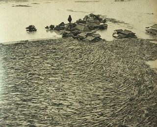
The 1982 Nagasaki flood was caused by a cloudburst that occurred mainly in Nagasaki, Japan in July 1982.
The 1953 Wakayama flood was caused by heavy rain that resulted in landslides and flooding in the Kii Peninsula, Wakayama Prefecture in Japan in July 1953. Collapse of the dikes occurred along many rivers, which caused flooding. It resulted in the deaths of 713 people and 411 people went missing.

The 1938 Hanshin flood was caused by heavy rains, which resulted in landslides and floods in the Mount Rokkō area, Hyōgo Prefecture in Japan in July 1938. According to the official government report, torrential rains resulted in flash floods and debris flows that affected the Mount Rokko area, including Kobe and Nishinomiya. At least 715 people lost their lives. The floods feature in Junichirō Tanizaki's novel The Makioka Sisters.

