
An earthquake occurred on November 27, 2005, at 13:52 IRST on the sparsely populated Qeshm Island off Southern Iran, killing 13 people and devastating 13 villages. It was Iran's second major earthquake of 2005, following the one at Zarand in February. The epicenter was about 1,500 kilometers (930 mi) south of Tehran, close to Iran's southern borders. Initial measurements showed that the earthquake registered about 6.0 on the moment magnitude scale, although that was reduced to 5.8 after further analysis. More than 400 minor aftershocks followed the main quake, 36 of which were greater than magnitude 2.5. The earthquake occurred in a remote area during the middle of the day, limiting the number of fatalities. Iranian relief efforts were effective and largely adequate, leading the country to decline offers of support from other nations and UNICEF.
The 2006 Kamchatka earthquake occurred on . This shock had a moment magnitude of 7.6 and a maximum Mercalli intensity of X (Extreme). The hypocenter was located near the coast of Koryak Autonomous Okrug at an estimated depth of 22 km, as reported by the International Seismological Centre. This event caused damage in three villages and was followed by a number of large aftershocks. Two M6.6 earthquakes struck on April 29 at 16:58 UTC and again on May 22 at 11:12 UTC. These earthquakes caused no deaths; however, 40 people were reported injured.
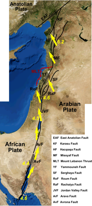
The Dead Sea Transform (DST) fault system, also sometimes referred to as the Dead Sea Rift, is a series of faults that run for about 1,000 km from the Maras Triple Junction to the northern end of the Red Sea Rift. The fault system forms the transform boundary between the African Plate to the west and the Arabian Plate to the east. It is a zone of left lateral (sinistral) displacement, signifying the relative motions of the two plates. Both plates are moving in a general north-northeast direction, but the Arabian Plate is moving faster, resulting in the observed left lateral motions along the fault of approximately 107 km at its southern end. A component of extension is also present in the southern part of the transform, which has contributed to a series of depressions, or pull-apart basins, forming the Gulf of Aqaba, Dead Sea, Sea of Galilee, and Hula basins. A component of shortening affects the Lebanon restraining bend, leading to uplift on both sides of the Beqaa valley. There is local transtension in the northernmost part of the fault system, forming the Ghab pull-apart basin. The fault system runs roughly along the political border of Israel, Jordan, and Lebanon.

The 2004 Al Hoceima earthquake occurred on 24 February at 02:27:47 local time near the coast of northern Morocco. The strike-slip earthquake measured 6.3 on the moment magnitude scale and had a maximum perceived intensity of IX (Violent) on the Mercalli intensity scale. Between 628 and 631 people were killed, 926 injured, and up to 15,000 people were rendered homeless in the Al Hoceima-Imzourene-Beni Abdallah area.
The Dasht-e Bayaz and Ferdows earthquakes occurred in Dashte Bayaz, Kakhk and Ferdows, Iran in late August and early September 1968. The mainshock measured 7.4 on the moment magnitude scale and had a maximum perceived intensity of X (Extreme) on the Mercalli intensity scale. Damage was heavy in the affected areas with thousands of lives lost in the first event and many hundreds more in the second strong event.

The 2002 Denali earthquake occurred at 22:12:41 UTC November 3 with an epicenter 66 km ESE of Denali National Park, Alaska, United States. This 7.9 Mw earthquake was the largest recorded in the United States in 37 years. The shock was the strongest ever recorded in the interior of Alaska. Due to the remote location, there were no fatalities and only one injury.
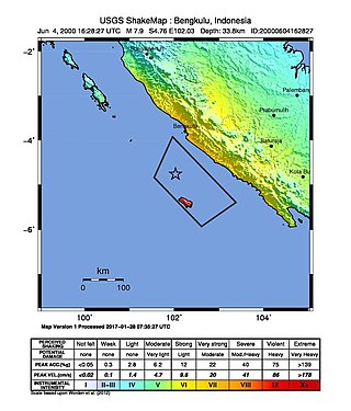
At 23:28 local time on June 4, 2000 southern Sumatra, Indonesia was struck by an earthquake of moment magnitude 7.9 with a maximum Mercalli intensity of VI (Strong). The event occurred off the coast near Enggano Island. There were more than 100 fatalities and up to 2,585 injuries. Over 730 aftershocks shook the area afterwards, one just eleven minutes after the mainshock.
The 1995 Antofagasta earthquake occurred on July 30 at 05:11 UTC with a moment magnitude of 8.0 and a maximum Mercalli intensity of VII. The Antofagasta Region in Chile was affected by a moderate tsunami, with three people killed, 58 or 59 injured, and around 600 homeless. Total damage from the earthquake and tsunami amounted to $1.791 million.

The Sagaing Fault is a major fault in Myanmar, a mainly continental right-lateral transform fault between the Indian Plate and Sunda Plate. It links the divergent boundary in the Andaman Sea with the zone of active continental collision along the Himalayan front. It passes through the populated cities of Mandalay, Yamethin, Pyinmana, the capital Naypyidaw, Toungoo and Pegu before dropping off into the Gulf of Martaban, running for a total length of over 1200 kilometers.
The 1975 North Atlantic earthquake occurred on May 26 at 09:11 UTC. The epicenter was located in the North Atlantic, in an area between the Azores, Iberian Peninsula, and Morocco. It had a magnitude of Mw 7.9, or Ms 8.1.
An earthquake occurred in southern Mongolia on December 4, 1957, measuring 7.8–8.1 and assigned XII (Extreme) on the Modified Mercalli intensity scale. Surface faulting was observed in the aftermath with peak vertical and horizontal scarp reaching 9 m (30 ft). Because of the extremely sparse population in the area, this event, despite its magnitude, was not catastrophic. However, 30 people died and the towns of Dzun Bogd, Bayan-leg and Baruin Bogd were completely destroyed.
The 1969 Tulbagh earthquake occurred at 20:03:33 UTC on 29 September. It had a magnitude of 6.3 and a maximum felt intensity of VIII (Severe) on the Modified Mercalli intensity scale. It caused widespread damage in the towns of Ceres, Tulbagh and Wolseley and led to 12 deaths. The earthquake was a result of strike-slip faulting along a NW-SE trending near vertical fault plane, as shown by the focal mechanism and the distribution of aftershocks.
The 1979 Ghaenat earthquakes were a series of large earthquakes in Qaen County, Khorasan Province, northeast Iran, near the Afghanistan border. The first mainshock, known as the Korizan earthquake with a surface wave magnitude (Ms ) of 6.6 and moment magnitude (Mw ) of 6.8, struck on November 14, while the Ms 7.1 or Mw 7.2 Koli-Boniabad earthquake struck on November 27. The two mainshocks were assigned a maximum Modified Mercalli intensity of VIII (Severe) and X (Extreme), respectively. The earthquakes caused extensive damage throughout northeastern Iran, killing an estimated 297 to 440 people and left at least 279 injured.
The 1983 Hindu Kush earthquake occurred south of Fayzabad, Badakhshan in northeast Afghanistan at 03:52 PST on December 31, 1983, near the border with Pakistan and the USSR. Striking 214.5 km beneath the Hindu Kush mountains, the moment magnitude 7.4 quake affected three countries, killing at least 26 people and injuring several hundred.
The 1969 Alaşehir earthquake occurred on March 28 at 03:48 local time near the city of Alaşehir in Turkey's Manisa Province. The Mw 6.8 earthquake struck at 10 km (6.2 mi) depth. It had a MSK 64 intensity of VIII (Destructive). At least 53 people were killed in the earthquake.
The 1997 Bojnurd earthquake occurred on 4 February at 14:07 IRST in Iran. The epicenter of the 6.5 earthquake was in the Kopet Dag mountains of North Khorasan, near the Iran–Turkmenistan border, about 579 km (360 mi) northeast of Tehran. The earthquake is characterized by shallow strike-slip faulting in a zone of active faults. Seismic activity is present as the Kopet Dag is actively accommodating tectonics through faulting. The earthquake left 88 dead, 1,948 injured, and affected 173 villages, including four which were destroyed. Damage also occurred in Shirvan and Bojnord counties. The total cost of damage was estimated to be over US$ 30 million.
The 1977 Bob–Tangol earthquake struck Kerman province of Iran on December 20, 1977 at 03:04 Iran Standard Time. The earthquake measured 5.9 and struck at a depth of 22.7 km (14.1 mi). A maximum Modified Mercalli intensity of VII was evaluated based on damage. It had a strike-slip focal mechanism, which was unusual as the source structure was a thrust fault. It was part of a sequence of strong earthquakes along the 400 km (250 mi) Kuh Banan Fault. Between 584 and 665 people perished while a further 500–1,000 were injured; thousands were also made homeless. Casualties from the earthquake was considered moderate due to the sparsely populated area it affected. Preceded by foreshocks the month before, many residents became wary of a larger earthquake and took refuge outside their homes, contributing to the moderate death toll. However, there were none immediately before the mainshock so many were still in their homes when it struck. Aftershocks were felt for several months, some causing additional damage.
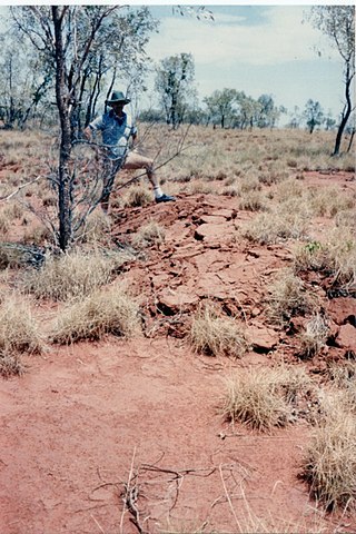
On 22 January 1988, a sequence of destructive earthquakes measuring 6.2, 6.3, and 6.6 struck southwest of Tennant Creek, Australia which was felt as far north as Darwin and in other regions of the country. The largest event of the sequence was the largest earthquake ever recorded in mainland Australia since records began in 1800. An intensity of IX (Violent) was observed. Despite the large magnitude of the earthquakes and a close proximity to a town, in a country where earthquakes of this size are not common, damages were limited. Thousands of aftershocks were reported and felt across Northern Territory.
The 1977 Naghan earthquake struck Chaharmahal and Bakhtiari province in Iran on April 6 at 13:36 UTC. The earthquake measuring 6.0 Mw occurred at a depth of 15 km (9.3 mi) and had a maximum Modified Mercalli intensity of VIII (Severe). More than 2,100 homes were destroyed and at least 348 people were killed.
The 1983 Kaoiki earthquake struck southern Hawaii Island on the morning of November 16, 1983. Measuring Mw 6.7, it was the largest to hit the island since 1975. The epicenter was located 50 km (30 mi) southeast of Hilo with an approximated depth of 12 km (7 mi). The shallow strike-slip earthquake was assigned a maximum intensity of IX (Violent) on the Modified Mercalli scale. 6 people were injured, widespread damage and landslides were reported across the island.

