The floods in Bangladesh occurred on 23 May 2022, Bangladesh is a land of many rivers, and as a result it is very prone to flooding due to being situated on the Brahmaputra River Delta and the many distributaries flowing into the Bay of Bengal. Due to being part of such a basin and being less than 5 meters above mean sea level, Bangladesh faces the cumulative effects of floods due to water flashing from nearby hills, the accumulation of the inflow of water from upstream catchments, and locally heavy rainfall enhanced by drainage congestion. Bangladesh faces this problem almost every year. Coastal flooding, combined with the bursting of river banks is common, and severely affects the landscape and society of Bangladesh. 80% of Bangladesh is floodplain, and it has an extensive sea coastline, rendering the nation very much at risk of periodic widespread damage. Whilst more permanent defenses, strengthened with reinforced concrete, are being built, many embankments are composed purely of soil and turf and made by local farmers. Flooding normally occurs during the monsoon season from June to September. The convectional rainfall of the monsoon is added to by relief rainfall caused by the Himalayas. Meltwater from the Himalayas is also a significant input.

The 1996 North Indian Ocean cyclone season featured several deadly tropical cyclones, with over 2,000 people killed during the year. The India Meteorological Department (IMD) – the Regional Specialized Meteorological Center for the northern Indian Ocean as recognized by the World Meteorological Organization – issued warnings for nine tropical cyclones in the region. Storms were also tracked on an unofficial basis by the American-based Joint Typhoon Warning Center, which observed one additional storm. The basin is split between the Bay of Bengal off the east coast of India and the Arabian Sea off the west coast. During the year, the activity was affected by the monsoon season, with most storms forming in June or after October.

Severe Cyclonic Storm Aila was the second named tropical cyclone of the 2009 North Indian Ocean cyclone season. Warned by both the Regional Specialized Meteorological Center (RMSC) and Joint Typhoon Warning Center (JTWC), Aila formed over a disturbance over the Bay of Bengal on May 23, 2009 and started to intensify and organize reaching sustained wind speeds of 110 kmh (70 mph). It was the worst natural disaster to affect Bangladesh since Cyclone Sidr in November 2007. A relatively strong tropical cyclone, it caused extensive damage in India and Bangladesh.

The 2010 Ladakh floods occurred on 6 August 2010 across a large part of Ladakh, then part of the state of Jammu and Kashmir. 71 towns and villages were damaged, including the main town in the area, Leh. At least 255 people are reported to have died, six of whom were foreign tourists, after a cloudburst and heavy overnight rains triggered flash floods, mudflows, and debris flows. 200 people were reported missing in the initial aftermath of the storm, and thousands more were rendered homeless after the flooding caused extensive damage to property and infrastructure. Overall, 9000 people were directly affected by the event.
In June 2013, a mid-day cloudburst centered on the North Indian state of Uttarakhand caused devastating floods and landslides, becoming the country's worst natural disaster since the 2004 tsunami. The rainfall received that month was far greater than the rainfall the state usually received. Debris blocked the rivers, causing major overflow.The main day of the flood was 16 June 2013.

In September 2014, the Kashmir region suffered disastrous floods across many of its districts caused by torrential rainfall. The Indian administered state of Jammu and Kashmir, as well as the Pakistani administered territories of Azad Kashmir, Gilgit-Baltistan and the province of Punjab were affected by these floods. By 24 September 2014, nearly 277 people in India and about 280 people in Pakistan had died due to the floods.
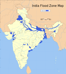
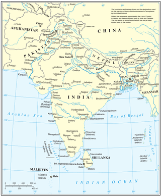
This is a list of notable recorded floods that have occurred in India. Floods are the most common natural disaster in India. The heaviest southwest, the Brahmaputra, and other rivers to distend their banks, often flooding surrounding areas.

Deep Depression ARB 02 was a weak tropical cyclone which brought heavy rains and flooding to the Indian state of Gujarat in June 2015. It was the third tropical cyclone and second deep depression of the 2015 North Indian Ocean cyclone season.

Following heavy rain, Gujarat state of India was affected by the flood in July 2015. The flood resulted in at least 72 deaths.

The 2015 South India floods resulted from heavy rainfall generated by the annual northeast monsoon in November–December 2015. They affected the Coromandel Coast region of the South Indian states of Tamil Nadu and Andhra Pradesh. More than 500 people were killed and over 1.8 million people were displaced. With estimates of damages and losses ranging from nearly ₹200 billion (US$3 billion) to over ₹1 trillion (US$13 billion), the floods were the costliest to have occurred in 2015, and were among the costliest natural disasters of the year.
The Brahmaputra floods refers to a catastrophic flood event that occurred in 2012 along the Brahmaputra River and its tributaries, as well as in subsequent years.
In mid-March 2019, monsoonal downpours caused widespread flooding and landslides across South Asia.
The 2019 Indian floods were a series of floods that affected over thirteen states in late July and early August 2019, due to excessive rains. At least 200 people died and about a million people were displaced. Karnataka and Maharashtra were the most severely affected states. People died but many were rescued with the help of the Indian Navy.
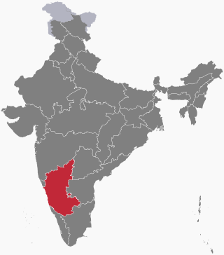
On 1 August 2019, first week, due to heavy rainfall in the Monsoon season, severe flood affected the southern Indian State of Karnataka. As a security measure in the prevailing situation of heavy rains, India Meteorological Department issued Red alert to several regions of coastal and malnad regions of Karnataka state.

The 1992 India–Pakistan floods was a deadly flood caused by a five days long heavy monsoon rains and severe weather that occurred on 7 September 1992 across the north-Pakistan of Azad Kashmir, North-West Frontier Province and Indian administered state of Jammu and Kashmir. Severe floods left at least 2,496 fatalities, including 2,000 deaths in Pakistan administered state, 296 in Punjab province, and 200 in northern India with several others missing. The floods swept away more than 12,672 villages and several people were buried alive due to landslides near mountains. Punjab, that shares its borders with Azad Kashmir, suffered a heavy agriculture loss in its economic history.

2020 Assam floods refers to the significant flood event of the Brahmaputra River in the Indian north-eastern state of Assam and coincided with the COVID-19 pandemic. Initial flooding started in May 2020 due to heavy rainfall affecting 30,000 and destroying crops across 5 districts. As of October 2020 the floods affected over five million people, claiming the lives of 123 people, with an additional 26 deaths due to landslides, 5474 villages were affected and over one hundred and fifty thousand people found refuge in relief camps.
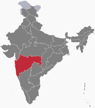
A series of floods took place across the Indian State of Maharashtra in 2021. As of 28 July 2021, around 251 people have died and over 100 are still missing due to floods and landslides. Thirteen districts have been affected in western Maharashtra.
From January to October 2022, excessive rainfall and widespread monsoon flooding occurred in the South Asian countries of Afghanistan, Bangladesh, India, Nepal, Pakistan, and Sri Lanka. It has become the region's deadliest floods since 2020, with over 3,700 people dead.