Harvest is an unincorporated community and census-designated place (CDP) in the northwestern part of Madison County, Alabama, United States, and is included in the Huntsville-Decatur Combined Statistical Area. According to the 2020 U.S. Census, the population of the community is 5,893.

The 1974 Super Outbreak was the second-largest tornado outbreak on record for a single 24-hour period, just behind the 2011 Super Outbreak. It was also the most violent tornado outbreak ever recorded, with 30 F4/F5 tornadoes confirmed. From April 3–4, 1974, there were 148 tornadoes confirmed in 13 U.S. states and the Canadian province of Ontario. In the United States, tornadoes struck Illinois, Indiana, Michigan, Ohio, Kentucky, Tennessee, Alabama, Mississippi, Georgia, North Carolina, Virginia, West Virginia, and New York. The outbreak caused roughly $843 million USD in damage, with more than $600 million occurring in the United States. The outbreak extensively damaged approximately 900 sq mi (2,331 km2) along a total combined path length of 2,600 mi (4,184 km). At one point, as many as 15 separate tornadoes were occurring simultaneously.

The tornado outbreak of April 15–16, 1998, also known as the 1998 Nashville tornado outbreak, was a two-day tornado outbreak that affected portions of the Midwestern United States, Mississippi and Tennessee Valleys on April 15 and April 16, 1998, with the worst of the outbreak taking place on the second day. On that day, 13 tornadoes swept through Middle Tennessee—two of them touching down in Nashville, causing significant damage to the downtown and East Nashville areas. Nashville became the first major city in nearly 20 years to have an F2 or larger tornado make a direct hit in the downtown area.

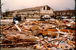
A destructive tornado outbreak struck a wide swath of the Southern and Eastern United States as well as Canada on November 15 and 16, 1989. It produced at least 40 tornadoes and caused 30 deaths as a result of two deadly tornadoes. The most devastating event was the Huntsville, Alabama F4 tornado, which killed 21 on the afternoon of November 15. Nine more fatalities occurred at a single elementary school by an F1 tornado on November 16 in Newburgh, New York, although further survey revealed that this might have been a downburst instead. This outbreak also produced the most tornadoes in a single day in New Jersey. Several other significant tornadoes were reported across 15 states.

U.S. Route 431 (US 431), internally designated by the Alabama Department of Transportation (ALDOT) as State Route 1 (SR 1), is a major north–south state highway across the eastern part of the U.S. state of Alabama. Although US 431's south end is in Dothan, SR 1 continues south for about 13 miles (21 km) along US 231 to the Florida state line.

State Route 261 is a 6-mile (9.7 km) state highway that connects Helena with Pelham in northern Shelby County, as part of the Birmingham/Hoover metropolitan area. SR 261 is two lanes wide for the entirety of its route. It serves as a feeder route to numerous subdivisions in Helena and Pelham.

Research Park Boulevard runs from I-565 to Bob Wade Lane on the north and west sides of Huntsville in Madison County, Alabama. Much of the route is a limited access highway, with the entire route planned to be limited access. Plans call for the road to be extended to create a near-complete bypass around Huntsville.

The 2008 Super Tuesday tornado outbreak was a deadly tornado outbreak which affected the Southern United States and the lower Ohio Valley on February 5 and 6, 2008. The event began on Super Tuesday, while 24 states in the United States were holding primary elections and caucuses to select the presidential candidates for the upcoming presidential election. Missouri, Illinois, Arkansas, Alabama, and Tennessee were among the affected regions in which primaries were being held. Some voting locations were forced to close early due to the approaching severe weather.

The Huntsville Metropolitan Statistical Area is a metropolitan statistical area on the northern border of Alabama. The metro area's principal city is Huntsville, and consists of two counties: Limestone and Madison. As of the 2020 United States census, the Huntsville Metropolitan Area's population was 491,723, making it the 2nd-largest metropolitan area in Alabama and the 117th-largest in the United States.

The tornado outbreak of April 22–25, 2010 was a multi-day tornado outbreak across a large portion of the Southern United States, originally starting in the High Plains on April 22, 2010 and continuing through the Southern Plains on April 23, and the Mississippi and Tennessee Valleys on April 24. The most severe activity was on April 24, particularly in Mississippi. The outbreak was responsible for ten tornado-related fatalities on April 24, all in Mississippi from a single supercell that crossed the entire state.

The 2011 Super Outbreak was the largest, costliest, and one of the deadliest tornado outbreaks ever recorded, taking place in the Southern, Midwestern, and Northeastern United States from April 25 to 28, 2011, leaving catastrophic destruction in its wake. Over 175 tornadoes struck Alabama, Mississippi, and Tennessee, which were the most severely damaged states. Other destructive tornadoes occurred in Arkansas, Georgia, Kentucky, Louisiana, New York, and Virginia, with storms also affecting other states in the Southern and Eastern United States. In total, 360 tornadoes were confirmed by NOAA's National Weather Service (NWS) and Government of Canada's Environment Canada in 21 states from Texas to New York to southern Canada. Widespread and destructive tornadoes occurred on each day of the outbreak. April 27 was the most active day, with a record 216 tornadoes touching down that day from midnight to midnight CDT. Four of the tornadoes were rated EF5, which is the highest ranking on the Enhanced Fujita scale; typically these tornadoes are recorded no more than once a year.

On March 2 and 3, 2012, a deadly tornado outbreak occurred over a large section of the Southern United States into the Ohio Valley region. The storms resulted in 41 tornado-related fatalities, 22 of which occurred in Kentucky. Tornado-related deaths also occurred in Alabama, Indiana, and Ohio. The outbreak was the second deadliest in early March for the U.S. since official records began in 1950; only the 1966 Candlestick Park tornado had a higher death toll for a tornadic system in early March.

The 2011 Hackleburg–Phil Campbell tornado was an extremely deadly, violent, and long-tracked EF5 wedge tornado that devastated several towns in rural northern Alabama, before tearing through the northern suburbs of Huntsville and causing damage in rural portions of southern Tennessee on the afternoon and early evening of April 27, 2011. It was the deadliest tornado of the 2011 Super Outbreak, the largest tornado outbreak in United States history. The tornado reached a maximum width of 1.25 miles (2.01 km) and was estimated to have had peak winds of 210 mph (340 km/h). The tornado killed 72 people, making it the deadliest tornado in Alabama history, and injured at least 145 others. At the time, it was the deadliest tornado to strike the United States since the 1955 Udall, Kansas, tornado.
Madison County Schools is a school district in Madison County, Alabama, United States, headquartered in an unincorporated area, bordering Huntsville.

A relatively widespread, damaging, and deadly tornado outbreak struck the central and southern United States in late April 2014. The storm complex responsible for the outbreak produced multiple long-track tornadoes – seven were deadly, causing 35 fatalities. One additional death occurred in Florida, due to severe flooding associated with this system.

A significant and deadly severe weather event that affected the Southeastern United States on March 3, 2019. Over the course of 6 hours, a total of 41 tornadoes touched down across portions of Alabama, Georgia, Florida, and South Carolina. The strongest of these was an EF4 tornado that devastated rural communities from Marvyn Al through Smiths Station, Alabama to Talbotton, Georgia, killing 23 people and injuring at least 100 others. Its death toll represented more than twice the number of tornado deaths in the United States in 2018 as well as the deadliest single tornado in the country since the 2013 Moore EF5 tornado. An EF3 tornado also destroyed residences to the east of Tallahassee in Leon County, Florida, and was only the second tornado of that strength in the county since 1945. Several other strong tornadoes occurred across the region throughout the evening of March 3 and caused significant damage. A large number of EF0 and EF1 tornadoes also touched down.

A small but deadly tornado outbreak affected West and Middle Tennessee on the night of March 2 and into the morning of March 3, 2020, including a high-end EF3 tornado that hit Nashville and Mount Juliet, becoming the 6th costliest tornado in United States history, and a violent EF4 tornado that impacted areas in and just west of Cookeville. A total of 25 people were killed by the tornadoes, with an additional 309 being injured, and more than 70,000 lost electricity. The path of the Nashville tornado was very similar to the one that hit East Nashville in 1998. A few additional tornadoes were also confirmed in Alabama, southeastern Missouri, and western Kentucky. Total damage from the event reached $1.607 billion according to the National Centers for Environmental Information.

The 2020 Easter tornado outbreak was a widespread and deadly tornado outbreak that affected the Southeastern United States on Easter Sunday and Monday, April 12–13, 2020. Several tornadoes were responsible for prompting tornado emergencies, including the first one to be issued by the National Weather Service in Charleston, South Carolina. A large squall line formed and tracked through the mid-Atlantic on April 13, prompting more tornado warnings and watches. A total of 15 watches were produced during the course of the event, two of which were designated Particularly Dangerous Situations.

A significant tornado outbreak sequence took place from March 24–28, 2021 in the Southern United States just one week after another outbreak affected similar regions. There were 43 tornadoes confirmed across 11 states, with the bulk of activity primarily on March 25, which resulted in the Storm Prediction Center (SPC) issuing its second high-risk outlook for the month of March, as well as the second high-risk outlook for 2021. Several intense tornadoes touched down on that day, including ones that prompted the issuance of rare tornado emergencies near Hoover, Alabama, Brent and Centreville, Alabama, and in the Newnan, Georgia area. March 27 also saw widespread tornado activity mainly across East Texas, Southern Arkansas, Louisiana, and Western Tennessee with several strong tornadoes touching down. Scattered to widespread wind and hail damage occurred throughout the outbreak sequence, and repeated rounds of heavy rain caused widespread severe flash and river flooding across much of Tennessee.

An early-season tornado outbreak impacted the Southeastern United States on January 12, 2023, the result of a mid-level trough moving through, with moisture and the presence of a strong low-level jet aiding in the development of multiple severe thunderstorms. A strong EF2 tornado caused considerable damage in Winston County, Alabama, while another EF2 tornado struck Greensboro. A destructive high-end EF2 tornado struck Selma, causing widespread damage. The same storm produced a long-lived EF3 tornado that moved through Old Kingston, Titus, Equality, and Lake Martin, resulting in seven fatalities and several injuries in Autauga County alone. Another EF2 tornado from the storm struck Five Points, Stroud, and Standing Rock before crossing into Georgia. After the dissipation of that tornado, seven more tornadoes, four of which were strong, caused heavy damage across west-central Georgia, especially in LaGrange, Griffin, and Experiment, the latter two of which were struck by an EF3 tornado. Another EF2 tornado from the storm caused major damage and another fatality in the Jackson Lake area as well; an indirect death from the tornado also occurred the following day. Elsewhere, other tornadoes caused damage in Sumter and Mobile counties in Alabama, as well as parts of Mississippi, Tennessee, Kentucky, Illinois, and the Carolinas. In all, 39 tornadoes were confirmed.


