The 2005 Hindu Kush earthquake hit northeastern Afghanistan with a magnitude of 6.5 on December 12 at 21:47 (UTC). According to the United States Geological Survey's ShakeMap and Did You Feel It? products, the maximum Mercalli intensity was V (Moderate) at Chitral. Five people were killed in the Hindu Kush region and landslides blocked several roads near Bagh, Kashmir. The earthquake occurred some 65 miles away from Faizabad, a city in the Hindu Kush mountains, but it could be felt in many neighboring areas. It could even be felt about 200 miles away in Islamabad, Pakistan. The quake was strong enough to trigger panic among survivors of October's devastating earthquake, who came out from their makeshift shelters in freezing temperatures. Although magnitude-6 earthquakes typically cause severe damage, this quake caused relatively little due to the fact that it occurred deep underground.

The 1960 Agadir earthquake occurred 29 February at 23:40 Western European Time near the city of Agadir, located in western Morocco on the shore of the Atlantic Ocean. Despite the earthquake's moderate scale magnitude of 5.8, its relatively shallow depth (15.0 km) resulted in strong surface shaking, with a maximum perceived intensity of X (Extreme) on the Mercalli intensity scale. Between 12,000 and 15,000 people were killed and another 12,000 injured with at least 35,000 people left homeless, making it the most destructive and deadliest earthquake in Moroccan history. Particularly hard hit were Founty, the Kasbah, Yachech/Ihchach and the Talborjt area. The earthquake's shallow focus, close proximity to the port city of Agadir, and unsatisfactory construction methods were all reasons declared by earthquake engineers and seismologists as to why it was so destructive.
The 1976 Songpan–Pingwu earthquake that struck Songpan and Pingwu counties in Sichuan, China consisted of three mainshocks on the 16th, 21st, and 23rd (UTC) of August. A 1984 report gave the magnitudes as 7.2, 6.7, and 7.2, respectively. The magnitudes were subsequently recalculated as 6.7, 6.3, and 6.4 on the scale, and 7.0, 6.6, and 6.7 on the scale. These were preceded by an earthquake swarm lasting three years. During the period from August 16 to August 31 there were over 400 aftershocks of magnitude 3.0 or greater.

The 2008 Iceland earthquake was a doublet earthquake that struck on May 29 at 15:46 UTC in southwestern Iceland. The recorded magnitudes of the two main quakes were 5.9 and 5.8 Mw , respectively, giving a composite magnitude of 6.1 Mw . There were no human fatalities, but 30 injuries were reported and a number of sheep were killed. The epicenter of the earthquake was between the towns of Hveragerði and Selfoss, about 45 kilometers (28 mi) east-southeast of the capital, Reykjavík. It was the strongest earthquake to hit Iceland since the summer of 2000.

The 2009 Papua earthquakes occurred on January 4 local time in Indonesia's West Papua province. The very large earthquake doublet comprised a 7.6 initial shock that had a maximum Mercalli intensity of VI (Strong) and a second event measuring Mw 7.4 and a maximum Mercalli intensity of VII. The events took place less than three hours apart to the east-northeast of Sorong on the Bird's Head Peninsula and left at least four people dead and dozens injured.
The 1995 Neftegorsk earthquake occurred on 28 May at on northern Sakhalin Island in the Russian Far East. It was the most destructive earthquake known within the current territory of Russia, with a magnitude of 7.1 and maximum Mercalli intensity of IX (Violent) that devastated the oil town of Neftegorsk, where 1,989 of its 3,977 citizens were killed, and another 750 injured.
In seismology, doublet earthquakes – and more generally, multiplet earthquakes – were originally identified as multiple earthquakes with nearly identical waveforms originating from the same location. They are now characterized as single earthquakes having two main shocks of similar magnitude, sometimes occurring within tens of seconds, but sometimes separated by years. The similarity of magnitude – often within 0.4 magnitude – distinguishes multiplet events from aftershocks, which start at about 1.2 magnitude less than the parent shock and decrease in magnitude and frequency according to known laws.
The 2010 Oaxaca earthquake struck Oaxaca, Mexico on June 30, 2010, with an magnitude of 6.3. Many people in different cities left their beds and ran into the street, as the quake struck at 2:22 am. Helicopters and police vehicles were sent to inspect possible damage in Mexico City, primarily in downtown and central areas, where some buildings were evacuated. In Mexico City, some cases of power outage in Azcapotzalco, Iztapalapa, and Benito Juárez and cracks in buildings were reported. 1 person died in San Andrés Huaxpaltepec, Oaxaca.
The 1967 Mudurnu earthquake or more correctly, the 1967 Mudurnu Valley earthquake occurred at about 18:57 local time on 22 July near Mudurnu, Bolu Province, north-western Turkey. The magnitude 7.4 earthquake was one of a series of major and intermediate quakes that have occurred in modern times along the North Anatolian Fault since 1939.
The 2010 Mindanao earthquakes occurred in the southern Philippines in the Moro Gulf. This was a complex sequence of events including three main events of magnitude 7.3 or greater on the 23rd of July, and two significant aftershocks of magnitude 6.6 on the 24th and 29th. All of these were deep focus earthquakes, at depths from 565 km (351 mi) to 634 km (394 mi). This resulted in minimal, but very widespread shaking at the surface, with a maximum intensity of IV on the PEIS scale; consequently there were no reports of casualties or damage.
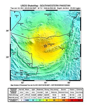
The 2011 Dalbandin earthquake occurred on with a moment magnitude of 7.2 and a maximum Mercalli intensity of VII. The shock occurred in a sparsely populated area of Balochistan, caused moderate damage, three deaths, and some injuries.

The Sagaing Fault is a major fault in Myanmar, a mainly continental right-lateral transform fault between the Indian Plate and Sunda Plate. It links the divergent boundary in the Andaman Sea with the zone of active continental collision along the Himalayan front. It passes through populated cities of Mandalay, Yamethin, Pyinmana, the capital Naypyidaw, Toungoo and Pegu before dropping off into the Gulf of Martaban, running for a total length of over 1200 kilometers.

The 2011 Lorca earthquake was a moderate 5.1 earthquake that occurred 6:47 p.m. CEST on 11 May 2011, near the town of Lorca, causing significant localized damage in the Region of Murcia, Spain, and panic among locals, and displacing many from their homes. The quake was preceded by a magnitude 4.4 foreshock at 17:05, that inflicted substantial damage to many older structures in the area, including the historical Espolón Tower of Lorca Castle, the Hermitage of San Clemente and the Convent of Virgen de Las Huertas. Three people were killed by a falling cornice. A total of nine deaths have been confirmed, while dozens are reported injured. The earthquake was the worst to hit the region since a 5.0 Mw tremor struck west of Albolote, Granada in 1956.
The 2012 East Azerbaijan earthquakes – also known as the Ahar earthquakes – occurred on 11 August 2012, at 16:53 Iran Standard Time, near the cities of Ahar and Varzaqan in Iran's East Azerbaijan Province, approximately 60 kilometers from Tabriz. They comprised a doublet separated by eleven minutes, with magnitudes of 6.4 and 6.2 . At least 306 people died and more than 3,000 others were injured, primarily in the rural and mountainous areas to the northeast of Tabriz. The shocks were felt in Armenia and the Republic of Azerbaijan, though no major damage was reported.

The 1990 Vrancea earthquakes were three earthquakes on 30 and 31 May 1990 with magnitudes of 7.0 and 6.2 Mw that struck the Romanian county of Vrancea, on two consecutive days. Severe damage in the Bucharest-Brăila-Brașov area was reported and dozens of casualties in Romania and neighbouring Moldova, Ukraine and Bulgaria.
The 1976 Longling earthquake in Yunnan Province, People's Republic of China, was a doublet earthquake, with two main shocks striking just east of Longling at 12:23:20 and 14:00:22 UTC. The magnitudes were estimated at 6.7 and 6.6, respectively, on the (GCMT) scale, and 6.9 and 7.0 on the scale; Chinese sources put these at 7.4 and 7.3 on the scale. The region is noted for the quantity and intensity of its earthquakes, and the complexity of its tectonics, which are closely related to the collision between the Indian and Eurasian tectonic plates.
The 1982 Ometepec earthquake that struck Mexico's southwestern coast near Ometepec (Guerrero) on 7 June was a doublet earthquake that ruptured in two steps. The first happened at 06:52 UTC, the second five hours later at 10:59 UTC. Estimated magnitudes are 6.9 and 7.0 on the scale, and 5.8 and 6.0 on the scale. The maximum Mercalli intensities were VII and VIII, respectively.
The 2019 Ridgecrest earthquakes of July 4 and 5 occurred north and northeast of the town of Ridgecrest, California located in Kern County and west of Searles Valley. They included three initial main shocks of magnitudes 6.4, 5.4, and 7.1, and many perceptible aftershocks, mainly within the area of the Naval Air Weapons Station China Lake. Eleven months later, a Mw 5.5 aftershock took place to the east of Ridgecrest. The first main shock occurred on Thursday, July 4 at 10:33 a.m. PDT, approximately 18 km (11.2 mi) ENE of Ridgecrest, and 13 km (8.1 mi) WSW of Trona, on a previously unnoticed NE-SW trending fault where it intersects the NW-SE trending Little Lake Fault Zone. This quake was preceded by several smaller earthquakes, and was followed by more than 1,400 detected aftershocks. The M 5.4 and M 7.1 quakes struck on Friday, July 5 at 4:08 a.m. and 8:19 p.m. PDT approximately 10 km (6 miles) to the northwest. The latter, now considered the mainshock, was the most powerful earthquake to occur in the state in 20 years. Subsequent aftershocks extended approximately 50 km (~30 miles) along the Little Lake Fault Zone.
The 1946 Sagaing earthquakes struck central Burma at 15:17 local time on 12 September. The first earthquake measured a magnitude of 7.3 Mw and was followed by a 7.7 Mw earthquake. Both events remain some of the largest in the country since the 1762 Arakan earthquake.
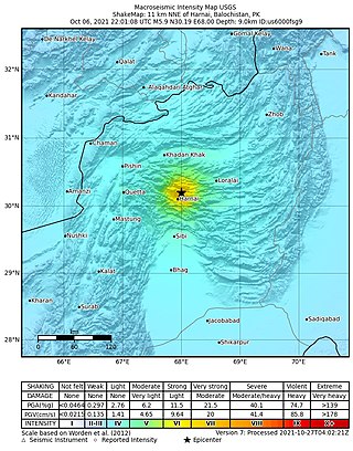
An earthquake struck Pakistan's province of Balochistan near the city of Harnai on 7 October 2021. The moment magnitude 5.9 Mww quake struck in the early morning at 03:01 local time, killing at least 42 people and injuring 300 others. The earthquake occurred just one day before the anniversary of the 2005 Kashmir earthquake.
