Related Research Articles

The Iller is a river of Bavaria and Baden-Württemberg in Germany. It is a right tributary of the Danube, 146 kilometres (91 mi) long.

The Isar is a river in Austria and in Bavaria, Germany. Its source is in the Karwendel mountain range of the Alps. The Isar river enters Germany near Mittenwald and flows through Bad Tölz, Munich, and Landshut before reaching the Danube near Deggendorf. With 295 km length, it is among the longest rivers in Bavaria. It is Germany's second most important tributary of the Danube.

The Silvretta Alps are a mountain range of the Central Eastern Alps shared by Tirol, Vorarlberg and Graubünden (Switzerland). The Austrian states of Tirol and Vorarlberg are connected by a pass road. The majority of the peaks are elevated above three thousand metres and are surrounded by glaciers. Thus, the area is also known as the "Blue Silvretta".
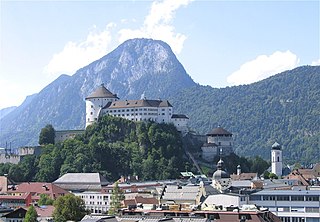
Kufstein is a town in the Austrian state of Tyrol, the administrative seat of Kufstein District. With a population of about 20,000 it is the second largest Tyrolean town after the state capital Innsbruck. The greatest landmark is Kufstein Fortress, first mentioned in the 13th century. The town was the place of origin of the Austrian noble family Kuefstein.

The Bavarian Alps is a collective name for several mountain ranges of the Northern Limestone Alps within the German state of Bavaria.

The Amper, called the Ammer upstream of the Ammersee, through which it runs, is the largest tributary of the Isar in southern Bavaria, Germany. It flows generally north-eastward, reaching the Isar in Moosburg, about 185 kilometres (115 mi) from its source in the Ammergau Alps, with a flow of 45 m³/s. Including its tributary, Linder, it is 209.5 km (130.2 mi) long. Major tributaries are the Glonn, which rises near Augsburg; the Würm, which is the outflow of Lake Starnberg; and the Maisach.

The Riss glaciation, Riss Glaciation, Riss ice age, Riss Ice Age, Riss glacial or Riss Glacial is the second youngest glaciation of the Pleistocene epoch in the traditional, quadripartite glacial classification of the Alps. The literature variously dates it to between about 300,000 to 130,000 years ago and 347,000 to 128,000 years ago. It coincides with the Saale glaciation of North Germany. The name goes back to Albrecht Penck and Eduard Brückner who named this cold period after the river Riss in Upper Swabia in their three-volume work Die Alpen im Eiszeitalter published between 1901 and 1909.

Seefeld in Tirol is an old farming village, now a major tourist resort, in Innsbruck-Land District in the Austrian state of Tyrol with a local population of 3,312. The village is located about 17 km (11 mi) northwest of Innsbruck on a plateau between the Wetterstein mountains and the Karwendel on a historic road from Mittenwald to Innsbruck that has been important since the Middle Ages. It was first mentioned in 1022 and since the 14th century has been a pilgrimage site, benefiting not only from the visit of numerous pilgrims but also from its stacking rights as a trading station between Augsburg and the Venice. Also since the 14th century, Tyrolean shale oil has been extracted in the area. Seefeld was a popular holiday resort even before 1900 and, since the 1930s, has been a well known winter sports centres and amongst the most popular tourist resorts in Austria. The municipality, which has been the venue for several Winter Olympics Games, is the home village of Anton Seelos, the inventor of the parallel turn.

The 2005 European floods hit mainly Romania, Switzerland, Austria and Germany, as well as several other countries in Central Europe and Eastern Europe during August 2005. The disaster came at a time when Portugal was suffering from intense forest fires which left 15 dead and days before the powerful Hurricane Katrina hit the United States.

The Eastern Alps are usually defined as the area east of a line from Lake Constance and the Alpine Rhine valley, up to the Splügen Pass at the Alpine divide, and down the Liro River to Lake Como in the south. The peaks and mountain passes are lower than the Western Alps, while the range itself is broader and less arched.
Neustadt an der Donau is a town in Lower Bavaria on the Danube in Bavaria, Germany. Lying on the western border of Landkreis Kelheim, Neustadt is primarily known for the thermal spa Bad Gögging. Neustadt had a population of 12,753 as of December 31, 2003.

The Allgäu Alps are a mountain range in the Northern Limestone Alps, located in Bavaria and Baden-Württemberg in Germany and Tyrol and Vorarlberg in Austria. The range lies directly east of Lake Constance.

The Wetterstein mountains, colloquially called Wetterstein, is a mountain group in the Northern Limestone Alps within the Eastern Alps. It is a comparatively compact range located between Garmisch-Partenkirchen, Mittenwald, Seefeld in Tirol and Ehrwald along the border between Germany (Bavaria) and Austria (Tyrol). Zugspitze, the highest peak is at the same time the highest mountain in Germany.

This division of Germany into major natural regions takes account primarily of geomorphological, geological, hydrological, and pedological criteria in order to divide the country into large, physical units with a common geographical basis. Political boundaries play no part in this, apart from defining the national border.

The Ammergau Alps are a mountain range in the Northern Limestone Alps in the states of Bavaria (Germany) and Tyrol (Austria). They cover an area of about 30 x 30 km and begin at the outer edge of the Alps. The highest summit is the Daniel which has a height of 2,340 metres (7,680 ft).

The Großache is a river, 79 kilometres (49 mi) long, in the east of the Austrian state of Tyrol and the Bavarian region of Chiemgau.

The Mangfall Mountains, or sometimes Mangfall Alps, are the easternmost part of the Bavarian Prealps that, in turn, belong to the Northern Limestone Alps. The name comes from the river Mangfall, whose tributaries, the Rottach, Weißach, Schlierach and Leitzach, drain large parts of the area and form an important drinking water reservoir for the city of Munich.

Tyrol is a historical region in the Alps of Northern Italy and western Austria. The area was historically the core of the County of Tyrol, part of the Holy Roman Empire, Austrian Empire and Austria-Hungary, from its formation in the 12th century until 1919. In 1919, following World War I and the dissolution of Austria-Hungary, it was divided into two modern administrative parts through the Treaty of Saint-Germain-en-Laye:

The Forggensee, also called the Roßhaupten Reservoir, is a reservoir located north of Füssen in the county of Ostallgäu in Bavaria, Germany and one of many lakes in the region around Hohenschwangau and Neuschwanstein castles. With a surface area of 15.2 km2, it is the fifth-largest lake in Bavaria and the largest reservoir in Germany by area. The River Lech flows through it. The Forggensee is known primarily as a tourist destination for aquatic sports and recreation. Besides Füssen, other settlements on the lake include Halblech, Rieden am Forggensee and Roßhaupten. The lake takes its name from the former hamlet of Forggen which has been submerged by the reservoir.
The Lechtal is an alpine valley in Austria, the greater part of which belongs to the state of Tyrol and the smaller part to Vorarlberg. The Lech river flows through the valley.
References
- ↑ "World: Europe Two die in Bavarian floods". BBC. 22 May 1999. Retrieved 27 September 2014.