
Entre Ríos is a central province of Argentina, located in the Mesopotamia region. It borders the provinces of Buenos Aires (south), Corrientes (north) and Santa Fe (west), and Uruguay in the east.

The Province of Santa Fe is a province of Argentina, located in the center-east of the country. Neighboring provinces are from the north clockwise Chaco, Corrientes, Entre Ríos, Buenos Aires, Córdoba, and Santiago del Estero. Together with Córdoba and Entre Ríos, the province is part of the economico-political association known as the Center Region.

The Red River flood of 1997 was a major flood that occurred in April and May 1997 along the Red River of the North in Minnesota, North Dakota, and southern Manitoba. It was the most severe flood of the river since 1826. The flood reached throughout the Red River Valley, affecting the cities of Fargo and Winnipeg, but none so greatly as Grand Forks and East Grand Forks, where floodwaters reached more than 3 miles (4.8 km) inland. They inundated virtually everything in the twin communities. Total damages for the Red River region were US$3.5 billion. The flood was the result of abundant snowfall and extreme temperatures.
Santa Fe de la Vera Cruz is the capital city of the province of Santa Fe, Argentina. It is situated in north-eastern Argentina, near the junction of the Paraná and Salado rivers. It lies 15 kilometres (9.3 mi) from the Hernandarias Subfluvial Tunnel that connects it to the city of Paraná. The city is also connected by canal with the port of Colastiné on the Paraná River. Santa Fe de la Vera Cruz has about 391,164 inhabitants per the 2010 census [INDEC]. The metropolitan area has a population of 653,073, making it the eighth largest in Argentina.
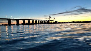
Rosario-Victoria Bridge is the informal name of the physical connection between the Argentine cities of Rosario and Victoria.

Villa Constitución is a city in the province of Santa Fe, Argentina, and the head town of the Constitución Department. It is located on the south-western banks of the Paraná River between the courses of the Arroyo Pavón and the Arroyo del Medio, about 214 km south from the provincial capital, the city of Santa Fe, and 50 km from Rosario. It has a population of more than 47,374 inhabitants as per the 2010 census [INDEC].

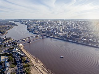
Victoria is a city located in the southwestern part of the province of Entre Ríos, Argentina. It is located on the eastern shore of the Paraná River, opposite Rosario, Santa Fe, to which it has been connected since 2003 by the Rosario-Victoria Bridge.

The Ludueña Stream is a small river in the province of Santa Fe, Argentina, which starts near the city of Rosario and flows through it, mostly east-southwards, ending in the Paraná River in the neighbourhood commonly known as Arroyito, near Rosario Central's football stadium.

The Salado River is a river that crosses several provinces of Argentina, flowing 1,150 kilometres (710 mi) from its source in the Salta Province to end in the Paraná River, in the Santa Fe Province. Because of its origin, its flow varies widely within the year, and it can dry out in some parts of its path during the winter. The only important tributary to the river is the Horcones River, which is born in Salta as Cajón River, and joins the Salado in the Santiago del Estero Province.

Rosario lies by the Paraná River, about 300 km upstream from the Argentine capital Buenos Aires; it is a major port and an industrial, commercial and cultural center. It grew from its humble origins to be the third most populated city in Argentina and the largest in the province of Santa Fe. Manuel Belgrano created the flag of Argentina in Rosario.
Events in the year 2003 in Argentina.
The Litoral region of Argentina underwent heavy rainstorms in the early autumn season of 2007. Starting in late March and ending in mid-April, the rains caused several major rivers to rise and/or overflow their banks, partly or completely flooded many towns and large cities, ruined a significant part of the crops in a wide region, and severely damaged the physical infrastructure. At least 15 people were killed as a result of the flooding.
National Route A007 also known as Mar Argentino or Avenida de Circunvalación in the city of Santa Fe, Decree #2084/1980, runs in a north–south direction, through the flood valleys of the Salado and Paraná rivers, around the city of Santa Fe.

Tropical Cyclone Les was a Category 2 storm in the 1997–98 Australian region cyclone season, which affected the Northern Territory of Australia in January 1998.

In October 1999, severe flooding affected portions of eastern Mexico and Central America. Rainfall in September preceded the primary event in Mexico, which moistened soils. On October 4, Tropical Depression Eleven developed in the Gulf of Mexico, which drew humidity from the gulf and the Pacific Ocean to produce torrential rainfall in mountainous regions of eastern Mexico, reaching 43.23 in (1,098 mm) in Jalacingo, Veracruz. This was the third-highest tropical cyclone-related rainfall total in Mexico from 1980–2006, and the event caused the highest rainfall related to tropical cyclones in Veracruz, Hidalgo, and Puebla. In some locations, the daily rainfall represented over 10% of the annual precipitation total. The heaviest rainfall occurred in mountainous regions that were the mouths of several rivers. A broad trough absorbed the depression on October 6, and rainfall continued for the next few days. Additional rainfall occurred in Tabasco state on October 18. The floods were estimated as a 1 in 67 year event in one location, although such floods are expected to affect eastern Mexico twice per century, the last time being 1944.

Typhoon Wipha, known in the Philippines as Super Typhoon Goring, was the strongest typhoon to threaten the Chinese coastline since Typhoon Saomai in August 2006. Forming out of a tropical disturbance on September 15, 2007, it quickly developed into a tropical storm, and intensified into a typhoon the following day with the appearance of an eye feature. After a period of rapid intensification, Wipha attained its peak intensity on September 18, with winds of 185 km/h (115 mph) and a barometric pressure of 925 mbar (hPa), according to the Japan Meteorological Agency. Later that day, the storm began to weaken as it interacted with the mountainous terrain of Taiwan before brushing the northern edge of the island. Wipha subsequently made landfall near Fuding along the Fujian–Zhejiang provincial border with winds estimated at 185 km/h (115 mph) by the JTWC. Shortly thereafter, the typhoon weakened as it moved inland, weakening to a tropical storm within 18 hours of moving over land.

The effects of Hurricane Georges in Cuba included $305.8 million in damages and six deaths. Forming out of a tropical wave over the Atlantic Ocean, Georges attained a peak intensity of 155 mph (249 km/h) on September 20, 1998. On September 23, the storm made landfall in southeastern Cuba as a minimal Category 1 hurricane. The storm tracked over the county for the following two days before emerging into the Gulf of Mexico on September 25 and later making landfall in the United States as a Category 2 hurricane. Before the storm's landfall in Cuba, officials reported that 200,000 people were evacuated to shelters; however, later reports indicated that upwards 711,000 people evacuated. A state of emergency was declared for much of eastern Cuba and most of the country was placed under a tropical storm or hurricane warning during the storm's passage.
The Paraná Miní River English: Río Paraná Miní) is an anabranch, or "secondary branch", and tributary of the Paraná River. It is located in the provinces of Santa Fe and Chaco, Argentina. In Chaco Province the Paraná Miní receives several relatively small tributaries, including the Tapenagá River, Palometa River, and Salado River.

The 2010 China floods began in early May 2010. Three hundred and ninety-two people died, and a further 232 people were reported missing as of June 30, 2010, including 57 people in a landslide in Guizhou. Fifty-three of the deaths occurred from the flooding and landslides between May 31 and June 3, and 266 deaths occurred between June 13 and June 29. Four hundred and twenty four people were killed by the end of June, including 42 from the Guizhou landslide; 277 more were killed and 147 were missing in the first two weeks of July, bringing the death toll as of August 5 to 1,072. A landslide in early August in Gansu killed at least 1,471 people and left 294 missing. In total, the flooding and landslides killed at least 3,185 people in China by August 31. More than 230 million people in 28 provinces, municipalities, and regions, especially the southern and central provinces and regions of Zhejiang, Fujian, Jiangxi, Hubei, Hunan, Guangdong, Guangxi, Chongqing Municipality, Gansu, Sichuan, and Guizhou, and the northeastern province of Jilin were affected, while at least 4.66 million people were evacuated because of the risk of flooding and landslides in the latter half of June. By early August, over 12 million people were evacuated, and that number rose to 15.2 million by August 31.
From mid-March to April 2019 widespread flash flooding affected large parts of Iran, most severely in Golestan, Fars, Khuzestan, Lorestan, and other provinces. Iran has been hit by three major waves of rain and flooding over the course of two weeks which led to flooding in at least 26 of Iran's 31 provinces and at least 70 people died nationwide as of 6 April, according to the officials. The first wave of rain began on 17 March, leading to flooding in two northern provinces, Golestan and Mazandaran with the former province receiving as much as 70 percent of its average annual rainfall in single day. Several large dams have been overflowed, particularly in Khuzestan and Golestan, therefore many villages and several cities have been evacuated. About 1,900 cities and villages across country have been damaged by severe floods as well as hundreds of millions of dollars of damage to water and agriculture infrastructure. 78 roads were blocked and the reliability of 84 bridges was questioned.
