2010 Guatemala City sinkhole

Last updated

2010 Guatemala City sinkhole
Guatemala City 2010 sinkhole 1.jpg
The 2010 sinkhole in Zona 2
Date30 May 2010
Location Guatemala City, Guatemala
Coordinates 14°39′07.6″N90°30′21″W / 14.652111°N 90.50583°W / 14.652111; -90.50583
Type Sinkhole
Deaths1

The 2010 Guatemala City sinkhole was a disaster on 30 May 2010, in which an area approximately 20 m (65 feet) in diameter and 90 m (300 feet) deep collapsed in Guatemala City's Zona 2, swallowing a three-story factory. [1] [2] [3] [4] The sinkhole occurred for a combination of reasons, including Tropical Storm Agatha, the Pacaya Volcano eruption, and leakage from sewer pipes. [5]

Contents

Background

Overall, the risk of sinkholes occurring in Guatemala City is very high and unpredictable. [6] One recent, similar sinkhole had collapsed in 2007, forming a pit 100 m (330 feet) deep. [7] [8] The 2007 Guatemala City sinkhole was formed by fluid from a sewer eroding uncemented volcanic ash, limestone, and other pyroclastic deposits underlying Guatemala City. [7] [8] The hazards around the pipe have since then been mitigated, by improved handling of the city's wastewater and runoff. [9] Several rainstorms also contributed to the sinkhole's collapse, as stormwater percolated into the ground, further dissolving the rocks beneath Guatemala City. [10] [11] The 2010 sinkhole was formed for similar reasons. [12]

Formation

Sewage pipes

Flooding triggered by Agatha in Guatemala Tropical Storm Agatha Guatemala Flooding.jpg
Flooding triggered by Agatha in Guatemala

The sinkhole formed due to volcanic pumice deposits, upon which Guatemala City is built. [3] These deposits were unconsolidated and of low density, allowing easy erosion. [3] According to Sam Bonis, a geologist at Dartmouth College, leaking pipes went unfixed long enough to create the conditions necessary for sinkhole formation because of lax city zoning regulations and building codes. [3] Bonis also says that the Guatemala City sinkhole is a misnomer: sinkholes have natural causes, but this one was mainly artificial. [3] In addition, according to Bonis, sinkholes are usually formed from limestone but there is no limestone hundreds of metres underneath Guatemala City. [3] Bonis proposes that the sinkhole be renamed a piping feature. [3]

Tropical Storm Agatha

Track of Tropical Storm Agatha Agatha 2010 track.png
Track of Tropical Storm Agatha

Tropical Storm Agatha was first identified as a trough of low pressure of the western coast of Costa Rica on 24 May 2010. [13] On May 29, the depression intensified into a tropical storm and was given the name Agatha. [14] Later that day, the system intensified slightly before making landfall near the Mexico-Guatemala border with winds of 72 km/h (45 mph). [15] By the morning of 30 May, the center of Agatha moved over the highest terrain in Central America, resulting in the dissipation of the low-level circulation. [16] Torrential rains from the storm widened the cavity, eventually causing the collapse of the sinkhole. [3]

Pacaya volcano eruption

The Pacaya Volcano Volcan-de-pacaya.jpg
The Pacaya Volcano

On 27 May, three days before Agatha became a tropical depression, the Pacaya volcano, located about 40 km (25 miles) south of Guatemala City, erupted, killing at least one person and blanketing nearby areas with layers of ash. [17] The eruption prompted officials to shut down the country's international airport. [18] Upon the formation of Agatha, people feared that excessive rainfall from the storm could exacerbate the situation and trigger lahars. [19] This had the effect of clogging the underground pipes with soot, increasing the chances of pipe rupture. [3] [4]

Collapse and aftermath

Mariela Castañón, a reporter for the daily newspaper La Hora, reported that the ground collapsed suddenly, taking a three-story house that was used as a factory, and possibly a security guard, along with it. Electricity poles were also sucked in. Authorities said they could not confirm the security guard's death. [1] [20]

Because of the role played by sewage pipes in the sinkhole's collapse, Sam Bonis, along with other geologists, has demanded that the government inspect the sewer system more regularly. [4]

According to officials, the sinkhole had similarities with another Guatemalan sinkhole which collapsed in 2007, which may also have been formed by ruptured sewage pipes. [4] [21] [22]

On a wider scale, immediately following reports of fatalities due to Agatha, a state of emergency was declared for Guatemala. [23] On 31 May, the government started to deploy national aid, and donation centers for victims of the storm were opened across the country. According to the Office for the Coordination of Humanitarian Affairs (OCHA), schools in Guatemala were to be closed until at least 4 June. [24]

Filling in the sinkhole

Immediately after the sinkhole's collapse, there were plans to fill it in with a soil cement made from cement, limestone, and water known locally as lodocreto ("mudcrete"). This substance was also used to fill in the 2007 Guatemala City sinkhole. However, another technique, which geologists call the graded-filter technique, in which the sinkhole is filled with successive layers of boulders, smaller rocks, and gravel, could possibly be a better solution. [25] This is because filling the hole in with cement diverts water runoff to other areas, potentially increasing the risk of sinkholes occurring in other parts of the city. The graded-filter technique, on the other hand, allows water to seep through. [26]

Related Research Articles

<span class="mw-page-title-main">Guatemala City</span> Capital and the largest city of Guatemala

Guatemala City, formally New Guatemala of Assumption and the Ancient, known locally as Guate, is the capital and largest city of Guatemala, and the most populous urban area in Central America. The city is located in the south-central part of the country, nestled in a mountain valley called Valle de la Ermita. The city is also the capital of the Guatemala Department.

<span class="mw-page-title-main">Geography of Guatemala</span> Set of physical features of Guatemala

Guatemala is mountainous, except for the south coastal area and the vast northern lowlands of Petén department. The country is located in Central America and bounded to the north and west by Mexico, to the east by Belize and by the Gulf of Honduras, to the east by Honduras, to the southeast by El Salvador, and to the south by the Pacific Ocean. Two mountain chains enter Guatemala from west to east, dividing the country into three major regions: the highlands, where the mountains are located; the Pacific coast, south of the mountains; and the limestone plateau of the Petén region, north of the mountains. These areas vary in climate, elevation, and landscape, providing dramatic contrasts between hot and humid tropical lowlands and highland peaks and valleys.

<span class="mw-page-title-main">Sinkhole</span> Geologically-formed topological depression

A sinkhole is a depression or hole in the ground caused by some form of collapse of the surface layer. The term is sometimes used to refer to doline, enclosed depressions that are locally also known as vrtače and shakeholes, and to openings where surface water enters into underground passages known as ponor, swallow hole or swallet. A cenote is a type of sinkhole that exposes groundwater underneath. Sink and stream sink are more general terms for sites that drain surface water, possibly by infiltration into sediment or crumbled rock.

<span class="mw-page-title-main">Stormwater</span> Water that originates during precipitation events and snow/ice melt

Stormwater, also written storm water, is water that originates from precipitation (storm), including heavy rain and meltwater from hail and snow. Stormwater can soak into the soil (infiltrate) and become groundwater, be stored on depressed land surface in ponds and puddles, evaporate back into the atmosphere, or contribute to surface runoff. Most runoff is conveyed directly as surface water to nearby streams, rivers or other large water bodies without treatment.

<span class="mw-page-title-main">Hurricane Mitch</span> Category 5 Atlantic hurricane in 1998

Hurricane Mitch was the second-deadliest Atlantic hurricane on record. Mitch caused 11,374 fatalities in Central America in 1998, including approximately 7,000 in Honduras and 3,800 in Nicaragua due to cataclysmic flooding from the slow motion of the storm. It was the deadliest hurricane in Central American history, surpassing Hurricane Fifi–Orlene, which killed slightly fewer people in that area in 1974. Mitch was the deadliest Atlantic hurricane in the satellite era, and the second-deadliest on record in the Atlantic, only behind the Great Hurricane of 1780 which killed at least 22,000 people.

<span class="mw-page-title-main">Pacaya</span> Mountain and national park in Guatemala

Pacaya is an active complex volcano in Guatemala, which first erupted approximately 23,000 years ago and has erupted at least 23 times since the Spanish conquest of Guatemala. It rises to an elevation of 2,552 metres (8,373 ft). After being dormant for over 70 years, it began erupting vigorously in 1961 and has been erupting frequently since then. Much of its activity is Strombolian, but occasional Plinian eruptions also occur, sometimes showering the area of the nearby Departments with ash.

<span class="mw-page-title-main">Lake Atitlán</span> Crater lake in Guatemala

Lake Atitlán is a lake in the Guatemalan Highlands of the Sierra Madre mountain range. The lake is located in the Sololá Department of southwestern Guatemala. It is known as the deepest lake in Central America.

San Vicente Pacaya is a town and municipality in the Escuintla department of Guatemala.

<span class="mw-page-title-main">Hurricane Stan</span> Category 1 Atlantic hurricane in 2005

Hurricane Stan was the deadliest tropical cyclone of the 2005 Atlantic hurricane season. A relatively weak system that affected areas of Central America and Mexico in early October 2005, Stan was the eighteenth named storm and eleventh hurricane of the 2005 season, having formed from a tropical wave on October 1 after it had moved into the western Caribbean. The depression slowly intensified, and reached tropical storm intensity the following day, before subsequently making its first landfall on the Yucatán Peninsula. While traversing the peninsula, the tropical storm weakened, but was able to re-intensify once it entered the Bay of Campeche. Under favorable conditions for tropical development, Stan attained hurricane strength on October 4, and later reached peak intensity with winds of 80 mph (130 km/h) and a minimum barometric pressure of 977 mbar (28.9 inHg). The hurricane maintained this intensity until landfall near Punta Roca Partida, Mexico later the same day. Once over the mountainous terrain of Mexico, however, Stan quickly weakened, and dissipated on October 5.

<span class="mw-page-title-main">2010 Pacific hurricane season</span> Hurricane season in the Pacific Ocean

The 2010 Pacific hurricane season was the least active Pacific hurricane season on record, tied with 1977. The season had the second-fewest ACE units on record, as many of the storms were weak and short-lived. Additionally, the season saw only 3 of the named storms strengthen into hurricanes. Of those, 2 became major hurricanes, and 1, Celia, reached Category 5 intensity on the Saffir-Simpson scale. However, despite the inactivity, it became the Third-costliest Pacific hurricane season of all time, mostly due to Agatha. The season officially began on May 15 in the eastern North Pacific and on June 1 in the central North Pacific. It ended in both regions on November 30. These dates, adopted by convention, historically describe the period in each year when most tropical cyclogenesis occurs in these regions of the Pacific. However, the formation of tropical cyclones is possible at any time of the year, as evidenced by the formation of Tropical Storm Omeka on December 19.

<span class="mw-page-title-main">Tropical Storm Agatha</span> Pacific tropical storm in 2010

Tropical Storm Agatha was a weak but deadly tropical cyclone that brought widespread floods to much of Central America, and was the deadliest storm in the eastern Pacific tropical cyclone basin since Hurricane Pauline in 1997. The first named storm of the 2010 Pacific hurricane season, Agatha originated from the Intertropical Convergence Zone, a region of thunderstorms across the tropics. It developed into a tropical depression on May 29 and tropical storm later, it was dissipated on May 30, reaching top winds of 45 mph and a lowest pressure of 1000 mbar. It made landfall near the Guatemala–Mexico border on the evening of May 29. Agatha produced torrential rain all across Central America, which resulted in the death of one person in Nicaragua. In Guatemala, 152 people were killed and 100 left missing by landslides. Thirteen deaths also occurred in El Salvador. Agatha soon dissipated over Guatemala. As of June 15, officials in Guatemala have stated that 165 people were killed and 113 others are missing.

<span class="mw-page-title-main">Effects of Tropical Storm Agatha in Guatemala</span>

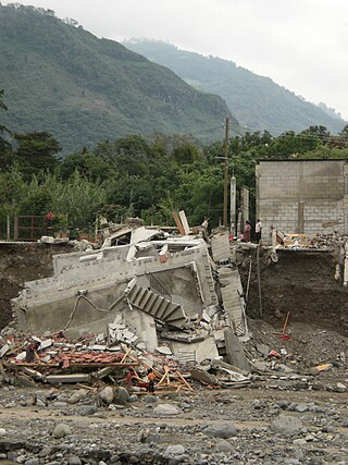
The effects of Tropical Storm Agatha in Guatemala were some of the worst from a tropical cyclone in the country on record, which included 182 deaths and nearly a billion dollars in damage. The storm rapidly formed and make landfall as a weak tropical storm on May 29, however, destructive floods contributed to mudslides and sinkholes affected the country until June 1, causing extensive damage.

The 2007 Guatemala City sinkhole is a 100-metre (330 ft) deep sinkhole which formed in Guatemala City in 2007, due to sewage pipe ruptures. Its collapse caused the deaths of five people, and the evacuation of over a thousand.

Little Blue Lake is a water-filled sinkhole (“cenote”) in the Australian state of South Australia located in the state's south-east in the locality of Mount Schank about 20 kilometres (12 mi) south of the municipal seat of Mount Gambier. It is notable locally as a swimming hole and nationally as a cave diving site. It is managed by the District Council of Grant and has been developed as a recreational and tourism venue.

<span class="mw-page-title-main">Tropical Storm Boris (2014)</span> Pacific tropical storm in 2014

Tropical Storm Boris was a weak and short-lived tropical cyclone that brought rainfall to the Isthmus of Tehuantepec and surrounding areas in June 2014. The second named storm of the season, Boris developed from the interaction of a low-level trough and a Kelvin wave south of Mexico late on June 2. Initially a tropical depression, the system moved generally northward and strengthened into Tropical Storm Boris by midday on June 3. About six hours later, Boris peaked with maximum sustained winds of 45 mph (75 km/h) – indicative of a weak tropical storm. By early on June 4, interaction with land caused the storm to weaken, deteriorating to a tropical depression. Later that day, Boris degenerated into a remnant low pressure, before fully dissipating over the Gulf of Tehuantepec on June 5.

<span class="mw-page-title-main">History of Guatemala City</span>

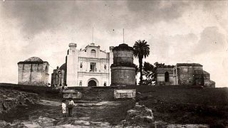
Human settlement on the present site of Guatemala City began with the Maya who built a city at Kaminaljuyu. The Spanish colonists established a small town, which was made a capital city in 1775. At this period the Central Square with the Cathedral and Royal Palace were constructed. After Central American independence from Spain the city became the capital of the United Provinces of Central America in 1821.

<span class="mw-page-title-main">Hurricane Lane (2018)</span> Category 5 Pacific hurricane

Hurricane Lane was a powerful tropical cyclone that brought torrential rainfall and strong winds to Hawaii during late August 2018. The storm was the wettest on record in Hawaii, with peak rainfall accumulations of 58 inches (1,473 mm) along the eastern slopes of Mauna Kea. The twelfth named storm, sixth hurricane, fourth major hurricane, and the first of three Category 5 hurricanes of the record-breaking 2018 Pacific hurricane season, Lane originated from an area of low pressure that formed well southwest of Mexico on August 13. Tracking west through a region of favorable atmospheric and oceanic conditions, the system steadily intensified over the following days. It reached an initial peak as a Category 4 hurricane on August 18. Temporarily inhibited by more hostile conditions, the hurricane weakened slightly before regaining strength and reaching Category 5 status on August 22 to the south of Hawaii. Lane peaked with winds of 160 mph (255 km/h) and a barometric pressure of 926 mbar. Thereafter, the hurricane turned north and slowed. During this period, torrential rains battered much of the Hawaiian Islands. Unfavorable conditions again affected the hurricane, and it degraded to a tropical depression by August 28 before dissipating the following day.

<span class="mw-page-title-main">Hurricanes in Honduras</span>

Honduras, officially the Republic of Honduras, is a country in Central America. To the west of Honduras is Guatemala, to the south is Nicaragua, to the southwest is El Salvador, and to the north is the Caribbean Sea.

References

  1. 1 2 Fieser, Ezra (1 June 2010). "Guatemala City sinkhole so big, so round it 'doesn't seem real'". Christian Science Monitor. Santo Domingo, Dominican Republic. Christian Science Monitor. Archived from the original on 1 October 2013. Retrieved 21 April 2013.
  2. Campbell, Andy (5 March 2013). "Killer Sinkholes: Unexpected Holes Swallow Entire Families, Cars And Homes (PHOTOS)". Huffington Post. Huffington Post. Archived from the original on 4 March 2013. Retrieved 21 April 2013.
  3. 1 2 3 4 5 6 7 8 9 Than, Ker (3 June 2010). "Guatemala Sinkhole Created by Humans, Not Nature". National Geographic. National Geographic. Archived from the original on 11 November 2013. Retrieved 21 April 2013.
  4. 1 2 3 4 Than, Ker (1 June 2010). "Sinkhole in Guatemala: Giant Could Get Even Bigger". National Geographic. National Geographic. Archived from the original on 27 October 2013. Retrieved 21 April 2013.
  5. North, Leslie A.; Polk, Jason S.; Nedvidek, Daniel (1 June 2014). "Getting Revved Up About Sinkholes!". Focus on Geography. 57 (2): 97–100. doi:10.1111/foge.12031. ISSN   1949-8535.
  6. Minard, Anne (4 June 2010). "Guatemala Sinkhole, 2010". Archived from the original on 21 October 2013. Retrieved 3 July 2013.
  7. 1 2 Waltham, T., 2008, Sinkhole hazard case histories in karst terrains. Archived 2009-02-13 at the Wayback Machine Quarterly Journal of Engineering Geology and Hydrogeology. vol. 41 no. 3, pp.. 291-300.
  8. 1 2 Halliday, W. R., 2007, Pseudokarst in the 21st century. Journal of Cave and Karst Studies. vol. 69, no. 1, p. 103–113.
  9. Reilly, Michael (4 June 2010). "Don't Call The Guatemala Sinkhole a Sinkhole". Archived from the original on 29 October 2013. Retrieved 6 May 2013.
  10. Chamberlain, Ted (26 February 2007). "Photo in the News: Giant Sinkhole Swallows Guatemala Homes". National Geographic. Archived from the original on 25 October 2013. Retrieved 5 May 2013.
  11. "Third body pulled from giant sinkhole". NBC News. NBC. 24 February 2007. Archived from the original on 21 October 2013. Retrieved 5 May 2013.
  12. Than, Ker (1 June 2010). "Sinkhole in Guatemala: Giant Could Get Even Bigger". National Geographic. Archived from the original on 27 October 2013. Retrieved 3 July 2013.
  13. Sandoval, Dave (24 May 2010). "Tropical Weather Discussion". National Hurricane Center. Retrieved 31 May 2010.
  14. Stewart, Stacey; Kimberlain, Todd (29 May 2010). "Tropical Storm Agatha Public Advisory Two". National Hurricane Center. Archived from the original on 24 October 2012. Retrieved 31 May 2010.
  15. Avila, Lixion A.; Cangialosi, John (29 May 2010). "Tropical Storm Agatha Tropical Cyclone Update". National Hurricane Center. Archived from the original on 24 October 2012. Retrieved 31 May 2010.
  16. Brown, Daniel (30 May 2010). "Tropical Depression Agatha Discussion Five (Final)". National Hurricane Center. Archived from the original on 24 October 2012. Retrieved 31 May 2010.
  17. Llorica, Juan (28 May 2010). "Guatemala Volcano: Pacaya Eruption Kills TV Reporter, 3 Missing (PHOTOS)". Huffington Post. Archived from the original on 9 December 2013. Retrieved 3 July 2013.
  18. "Guatemala warns of volcano danger". CNN. 22 July 2010. Archived from the original on 8 March 2013. Retrieved 3 July 2013.
  19. Campbell, Robert (29 May 2010). "Guatemala girds for first Pacific storm of season". Reuters. Archived from the original on 1 June 2010. Retrieved 29 May 2010.
  20. Castañón, Mariela (17 July 2010). "Hundimientos atraen a la prensa extranjera". La Hora. Archived from the original on 11 December 2013. Retrieved 21 April 2013.
  21. Guo, Shuai; Shao, Yu; Zhang, Tuqiao; Zhu, David. Z.; Zhang, Yiping (1 January 2013). "Physical Modeling on Sand Erosion around Defective Sewer Pipes under the Influence of Groundwater". Journal of Hydraulic Engineering. 139 (12): 1247–1257. doi:10.1061/(ASCE)HY.1943-7900.0000785. ISSN   0733-9429.
  22. Hermosilla, R. (1 April 2012). "New Information on the Guatemala City Sinkholes from Post Collapse Investigations". EGU General Assembly Conference Abstracts. 14: 1193. Bibcode:2012EGUGA..14.1193H.
  23. Hernandez, Herbert (29 May 2010). "Pacific storm Agatha's rains kill four in Guatemala". MSNBC. Reuters. Archived from the original on 1 June 2010. Retrieved 31 May 2010.
  24. Office for the Coordination of Humanitarian Affairs (31 May 2010). "América Central - Tormenta Tropical Agatha Informe de Situación #1" (PDF) (in Spanish). Red de Información Humanitaria. Archived from the original (PDF) on 8 March 2012. Retrieved 16 June 2010.
  25. Hermosilla, Rodolfo G. (15 November 2011). "The Guatemala City sinkhole collapses". Carbonates and Evaporites. 27 (2): 103–107. doi:10.1007/s13146-011-0074-1. ISSN   0891-2556. S2CID   129104329.
  26. Palmer, Brian (4 June 2010). "How To Fix a Giant Sinkhole". Slate Magazine. Archived from the original on 28 September 2013. Retrieved 16 September 2013.