2017 Bangladesh landslides

Last updated

Map key
  Tropical depression (≤38 mph, ≤62 km/h)
  Tropical storm (39–73 mph, 63–118 km/h)
  Category 1 (74–95 mph, 119–153 km/h)
  Category 2 (96–110 mph, 154–177 km/h)
  Category 3 (111–129 mph, 178–208 km/h)
  Category 4 (130–156 mph, 209–251 km/h)
  Category 5 (≥157 mph, ≥252 km/h)
  Unknown
Storm type
Disc Plain black.svg Tropical cyclone
Solid black.svg Subtropical cyclone
ArrowUp.svg Extratropical cyclone, remnant low, tropical disturbance, or monsoon depression

A low-pressure area formed over west central & adjoining north Bay of Bengal off north Andhra Pradesh south Odisha coast in the morning of June 10. [7] It concentrated into a well marked low-pressure area over northern parts of central Bay of Bengal & adjoining north Bay of Bay on 11th morning and into a depression over north Bay of Bengal in the evening of 11th.). [7] An anti-cyclonic circulation lay to the southeast of the system centre leading to poleward outflow favouring genesis of the system. [7] Moving nearly north-northeastwards, it intensified into a deep depression over north Bay of Bengal in the night of 11th (1800 UTC)and peaked with estimated 3-minute sustained windspeeds of 55 km/h (35 mph). [7] Moving north-northeastwards, it crossed Bangladesh coast near Khepupara between 2300 UTC of 11th and 0000 UTC of June 12. [7] As the system moved over land, it weakened gradually into a depression over east Bangladesh & neighbourhood due to land surface interaction and thereafter into a well marked low-pressure area. [7]

Cause of the disaster

The landslide was caused by an incessant downpour that began early morning of 12 June, dropping 34.3 centimetres (13.5 inches) of rain in 24 hours. [8] The monsoon and depression over Bay of Bengal towards Bangladesh resulted in heavy rain over different parts, including Dhaka and Chittagong. A study, performed after the events, indicated that the large portion of the area was already highly susceptible to landslide due to the existing factors such as steep slope, deforestation, hill cutting etc. and the intense rainfall acted as a triggering factor. [9] The seasonal monsoon often causes floods and mudslides in the southern hills of Bangladesh. [1] [5] Deforestation in the area also contributed to the devastation, as well as rapid urbanisation. [10] [6] [11] Indigenous leader Bijoy Giri Chakma told Channel NewsAsia that tree felling had completely denuded some hill slides, adding that he had never seen worse landslides. [8]

A second factor was lack of land forcing poor people to live in marginal areas where rents are low. [12] Bandarban government administrator Dilip Kumar Banik told the Associated Press that many people had built homes on slopes despite official warnings. [13] In Cox's Bazar, officials said that 300,000 people in the area live on landslide-prone hills. [14] The district administrators have ordered officials to create a list of homes at risk, and are discussing plans to relocate them, executive magistrate Saiful Islam told Bdnews24.com. [15]

Extent of the disaster

As of 15 June 2017, officials were reporting a death toll as high as 152 in both Bangladesh and neighbouring India, with hundreds injured and many missing. [1] [6] [11] [16] [8] [4] Officials expected the toll to rise. [1] [6] [11] [4]

Shah Kamal, secretary of the Ministry of Disaster Management, said it could take days to reach affected areas. [17] "The devastation is huge", he told the Associated Press. [17] In some areas, there was as much as 1.2 metres (four feet) of mud. [8]

The worst-hit district was Rangamati, where landslides buried hillside houses where people were sleeping. [5] [6] At least 20 separate landslides hit the district. [4] Up to 105 deaths were reported as of 15 June, [1] [6] [11] [16] [18] [19] and 5,000 homes were damaged. [11] Roads in Rangamati remained inaccessible on 15 June. [18] Many roads in the district were washed away, leaving craters up to 15 metres (49 feet) deep, or heaped with debris. [19] The district's power grid was also destroyed. [19] There were also fuel and food shortages as of 15 June, and Belayet Hossain Mia Belal, president of the district chamber of commerce and industry, told the Daily Star that the food shortage could become dire in two to four days. [19]

Twenty-nine people were reported dead in Chittagong [6] [4] [18] and six in Bandarban. [4] [18] Roads in Bandarban were cleared by 15 June, when 2,000 people were able to return to their villages to see the devastation. [13]

Two people were killed in Cox's Bazar, the town hosting thousands of Rohingya Muslim refugees. [1]

Houses in Khagrachari district were flooded nearly to the rooftops. [1]

Two officers and two soldiers of the Bangladesh Army (Major Mohammad Mahfuzul Haq, Captain Md Tanvir Salam Shanto, Corporal Mohammad Azizul Haq and soldier Md Shahin Alam) were killed after a second landslide struck a highway-clearing operation in Rangamati. [5] [1] [6] [11] [16] The body of a fifth army personnel, soldier Md Azizur Rahman, was found 15 June. [8] [18] [19]

At least 11 people were killed in flooding in the Indian states of Mizoram and Assam, caused by the same storms. [1] [6]

Response

The Bangladesh government attempted to warn people ahead of the storm, using loudspeakers, but were not able to reach all areas. [6] [13] More than 10,000 people did get evacuated to emergency shelters. [6]

In the two days immediately after the landslides, rescue workers were having trouble reaching victims as roads were choked with mud and rain continued. [6] Heavy digging equipment could not reach remote areas. [11] As of 14 June, power and cell service were still off in the affected areas. [11] Doctors worked by candlelight to help the injured. [17]

Thousands of Bangladesh army soldiers were already stationed in the area because of a long-standing insurgency; and they were directed to help in the rescue effort. [6] The Bangladesh navy also helped reach people cut off by flooding. [1]

Reaz Ahmed, head of Bangladesh's Disaster Management Department, said the landslides were the worst in the country's history. [6] Bangladesh President Abdul Hamid and Prime Minister Sheikh Hasina made statements of shock and sympathy, praying for the affected and urging swift rescue action. [20] Radical Bangladesh pressure group Hefazat also issued a press release urging members to help victims and offering prayers and sympathy. [21] The government of Bangladesh also offered cash and building materials to affected families. [13] Local authorities offered temporary food and shelter. [15]

Abroad, Indian Prime Minister Narendra Modi tweeted condolences, prayers, and an offer of help with the rescue effort. [16] [1] The governments of Canada, the European Union, [22] the United Kingdom, [22] Pakistan, [23] the United States, [24] Iran, [25] Nepal, [26] and Russia [27] also sent condolences.

See also

Related Research Articles

<span class="mw-page-title-main">Bangladesh Armed Forces</span> Combined military forces of Bangladesh

The Bangladesh Armed Forces are the military forces of the People's Republic of Bangladesh. They consist of the three uniformed military services: the Bangladesh Army, the Bangladesh Navy and the Bangladesh Air Force. The Armed Forces are under the jurisdiction of Ministry of Defence of the Government of Bangladesh, and are directly administered by the Armed Forces Division of the Prime Minister's Office. The President of Bangladesh serves as the Commander-in-Chief of the Bangladesh Armed Forces. Bangladesh has the third-largest defence budget in South Asia and according to the Global Firepower index, The Bangladeshi military is the 37th strongest in the World is the third most powerful military force in South Asia. Border Guard Bangladesh and Bangladesh Coast Guard are under the jurisdiction of the Ministry of Home Affairs during peacetime, but during wartime they fall under the command of Bangladesh Army and Bangladesh Navy respectively.

<span class="mw-page-title-main">Chittagong Division</span> Division of Bangladesh

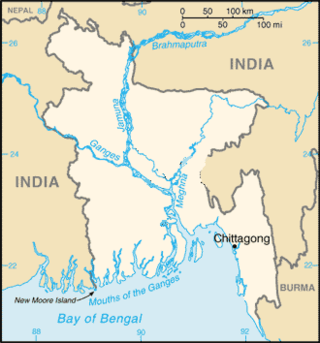
Chittagong Division, officially known as Chattogram Division, is geographically the largest of the eight administrative divisions of Bangladesh. It covers the south-easternmost areas of the country, with a total area of 34,529.97 km2 (13,332.10 sq mi) and a population at the 2022 census of 33,202,326. The administrative division includes mainland Chittagong District, neighbouring districts and the Chittagong Hill Tracts.

<span class="mw-page-title-main">Bandarban District</span> District in Chittagong Division, Bangladesh

Bandarban is a district in South-Eastern Bangladesh, and a part of the Chittagong Division. It is one of the three hill districts of Bangladesh and a part of the Chittagong Hill Tracts, the others being Rangamati District and Khagrachhari District. Bandarban district (4,479 km2) is not only the most remote district of the country, but also the least populous. There is an army contingent at Bandarban Cantonment.

<span class="mw-page-title-main">2007 Chittagong mudslides</span> 2007 natural disaster in Chittagong, Bangladesh

The 2007 Chittagong mudslides occurred in the port city of Chittagong in south-eastern Bangladesh. On 11 June 2007, heavy monsoon rainfall caused mudslides that engulfed slums around the hilly areas of the city. Experts had previously warned the increasing likelihood of landslides due to the Bangladesh government's failure in curbing the illegal hill cutting taking place in Chittagong.

<span class="mw-page-title-main">Tourism in Bangladesh</span> Overview of tourism in Bangladesh

Tourism in Bangladesh includes tourism to World Heritage Sites, historical monuments, resorts, beaches, picnic spots, forests, tribal people, and wildlife of various species. Activities for tourists include angling, water skiing, river cruising, hiking, rowing, yachting, and sea bathing.

<span class="mw-page-title-main">1995 North Indian Ocean cyclone season</span> Cyclone season 1995 in the North Indian ocean

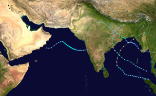
The 1995 North Indian Ocean cyclone season was below-average and was primarily confined to the autumn months, with the exception of three short-lived deep depressions in May. There were eight depressions in the basin, which is Indian Ocean north of the equator. The basin is subdivided between the Bay of Bengal and the Arabian Sea on the east and west coasts of India, respectively. Storms were tracked by the India Meteorological Department (IMD), which is the basin's Regional Specialized Meteorological Center, as well as the American-based Joint Typhoon Warning Center (JTWC) on an unofficial basis.

<span class="mw-page-title-main">Roman Catholic Archdiocese of Chittagong</span> Roman Catholic archdiocese in Bangladesh

The Roman Catholic Archdiocese of Chittagong, renamed Chattogram on December 28, 2018, is an archdiocese of the Latin Church of the Catholic Church in Bangladesh. The Archdiocese of Chittagong is the metropolitan see of the ecclesiastical province of Chittagong, which includes the suffragan dioceses of the Roman Catholic Diocese of Khulna and the Roman Catholic Diocese of Barisal, both in Bangladesh. However, it remains dependent on the missionary Roman Congregation for the Evangelization of Peoples.

<span class="mw-page-title-main">Cyclone Bijli</span> North Indian cyclone in 2009

Cyclonic Storm Bijli, was the first tropical cyclone to form during the 2009 North Indian Ocean cyclone season. Bijli formed from an area of Low Pressure on April 14. Later that evening, RSMC New Delhi upgraded the low-pressure area to a Depression and designated it as BOB 01. The Joint Typhoon Warning Center (JTWC) then issued a Tropical Cyclone Formation Alert for the system and soon after designated it as Tropical Depression 01B. On the evening of April 15, both RSMC New Delhi and the JTWC reported that the system had intensified into a tropical storm, with the former naming it Bilji. Soon after, Bilji reached its peak intensity as it approached the coast of Bangladesh. However, on the morning of April 17, Bijli weakened to a deep depression due to land interaction, before making landfall just south of Chittagong. The remnants of Bilji continued to weaken as they tracked across northern Myanmar, before RSMC New Delhi issued their last advisory on April 18. The word Bijli refers to lightning in Hindi.

<span class="mw-page-title-main">Cyclone Viyaru</span> North Indian Ocean cyclone in 2013

Cyclonic Storm Viyaru, operationally known as Cyclonic Storm Mahasen, was a relatively weak tropical cyclone that caused loss of life across six countries in Southern and Southeastern Asia. Originating from an area of low pressure over the southern Bay of Bengal in early May 2013, Viyaru slowly consolidated into a depression on May 10. The depression gained forward momentum and attained gale-force winds on May 11 and was designated as Cyclonic Storm Viyaru, the first named storm of the season. Owing to adverse atmospheric conditions, the depression struggled to maintain organized convection as it moved closer to eastern India. On May 14, the exposed circulation of Viyaru turned northeastward. The following day, conditions again allowed for the storm to intensify. Early on May 16, the cyclone attained its peak intensity with winds of 85 km/h (55 mph) and a barometric pressure of 990 mbar. Shortly thereafter Viyaru made landfall near Chittagong, Bangladesh. On May 17, it moved over the eastern Indian state of Nagaland.

2016 (MMXVI) was a leap year starting on Friday of the Gregorian calendar, the 2016th year of the Common Era (CE) and Anno Domini (AD) designations, the 16th year of the 3rd millennium and the 21st century, and the 7th year of the 2010s decade.

<span class="mw-page-title-main">Cyclone Komen</span> North Indian cyclone in 2015

Cyclonic Storm Komen was an unusual tropical cyclone that originated near the southern coast of Bangladesh and later struck the same country while drifting over the northern Bay of Bengal. The second named storm of the 2015 season, Komen brought several days of heavy rainfall to Myanmar, Bangladesh, and India. It formed as a depression on July 26 over the Ganges delta and moved in a circular motion around the northern Bay of Bengal. Komen intensified into a 75 km/h (45 mph) cyclonic storm and moved ashore southeastern Bangladesh on July 30. The system turned westward over land and was last noted over eastern India on August 2.

<span class="mw-page-title-main">2017 North Indian Ocean cyclone season</span> North Indian Ocean tropical cyclone season

The 2017 North Indian Ocean cyclone season was a below average yet deadly season in the annual cycle of tropical cyclone formation. This season produced only three named storms, of which one only intensified into a very severe cyclonic storm. The North Indian Ocean cyclone season has no official bounds but cyclones tend to form between April and December with the two peaks in May and November. These dates conventionally delimit the period of each year when most tropical cyclones form in the northern Indian Ocean. The season began with the formation Cyclone Maarutha on April 15 and ended with the dissipation of a deep depression on December 9.

The 2015 Bangladesh–Arakan Army border clash took place between 25 August 2015 and 26 August 2015 in the Bandarban District, near the Bangladesh–Myanmar border, after several insurgents of the Arakan Army attacked members of Border Guards Bangladesh.

<span class="mw-page-title-main">Cyclone Mora</span>

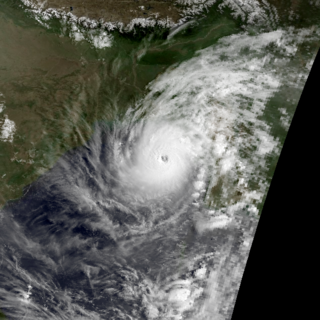
Severe Cyclonic Storm Mora was a moderate but deadly tropical cyclone that caused widespread devastation and severe flooding in Sri Lanka, Andaman and Nicobar Islands, Bangladesh, Myanmar and Northeast India in May 2017. The second named storm of the 2017 annual cyclone season, Mora developed from an area of low pressure over the southeastern Bay of Bengal on May 28. Mora reached peak strength with maximum sustained winds of 110 km/h (70 mph). The cyclone made landfall near Chittagong on the morning of May 30 and steadily weakened, dissipating early in the morning on May 31. Across its path, Mora dropped a large amount of rain, including 225mm of rainfall in Chittagong and northeast India. The storm is estimated to have caused damages nearing US$300 million.

<span class="mw-page-title-main">1994 Bangladesh cyclone</span> Category 4 North Indian tropical cyclone in 1994

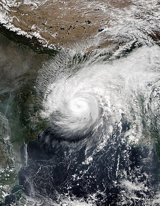
The 1994 Bangladesh cyclone was a powerful tropical cyclone in the Bay of Bengal. The cyclone closely followed the path, strength, and time of year of a deadly cyclone in 1991 that killed more than 138,000 people. The 1994 cyclone formed on April 29 as a depression, which organized and intensified significantly over the subsequent few days. On May 2, the cyclone attained winds of 215 km/h (135 mph), according to the India Meteorological Department (IMD). That day, the storm made landfall in southeastern Bangladesh, and rapidly weakened over land, before dissipating on May 3.

<span class="mw-page-title-main">Cyclone Matmo–Bulbul</span> West Pacific and North Indian cyclone in 2019

Cyclone Matmo–Bulbul is the unofficial collective designation given to both Severe Tropical Storm Matmo and Very Severe Cyclonic Storm Bulbul, which were a pair of destructive tropical cyclones that tracked in the Western Pacific Ocean and the North Indian Ocean in October and November 2019 respectively, killing 43 people and inflicting about US$3.537 billion in damage. Matmo was the 41st tropical depression and the 22nd named storm of the 2019 Pacific typhoon season, while Bulbul was the 9th depression and the 7th named storm of the 2019 North Indian Ocean cyclone season. The cyclone formed on October 28 in the South China Sea and intensified into Tropical Storm Matmo, as named by the Japan Meteorological Agency (JMA). On October 30, the storm made landfall in central Vietnam, causing flooding. Matmo weakened while moving westward across Mainland Southeast Asia, before degenerating into a remnant low later that day. The remnants of Matmo emerged into the Bay of Bengal, redeveloping into a depression on November 5. Late the next day, it strengthened into a cyclonic storm, renamed Bulbul by the India Meteorological Department (IMD), although the JTWC continued to refer to it as Matmo. The storm peaked on November 8, with maximum sustained winds 140 km/h (85 mph) estimated by the IMD. On November 9, the cyclone made its final landfall in the eastern Indian state of West Bengal, and around that time the storm turned to the northeast, moving into Bangladesh. The system degenerated into a remnant low two days later, over northeastern India.

The 2010s was a decade of the Gregorian calendar that began on January 1, 2010, and ended on December 31, 2019. For Bangladesh this decade was characterized by political stability from continued rule of Sheikh Hasina led Awami League Government. While the country made significant economic growth in this decade, rising threat from Islamist terrorism and Rohingya refugee problem marred the progress.

<span class="mw-page-title-main">Cyclone Amphan</span> North Indian Ocean cyclone in 2020

Super Cyclonic Storm Amphan was an extremely powerful and catastrophic tropical cyclone that caused widespread damage in Eastern India, specifically in West Bengal and Odisha, and in Bangladesh, in May 2020. It was the strongest tropical cyclone to strike the Ganges Delta. It was a rare cyclone that lashed northern Bangladesh from Rajshahi to Rangpur in the early hours of 21 May with strong winds. It was also the fourth super cyclone that hit West Bengal and Kolkata since 2015 as well as being one of the strongest storms to impact the area. Causing over US$13 billion of damage, Amphan is also the costliest cyclone ever recorded in the North Indian Ocean, surpassing the record held by Cyclone Nargis of 2008.

<span class="mw-page-title-main">Cyclone Titli</span> Deadly tropical cyclone that impacted the East coast of India

Very Severe Cyclonic Storm Titli was a deadly and destructive tropical cyclone that caused extensive damage to Eastern India in October 2018. Titli was the twelfth depression and fifth named storm to form in the 2018 North Indian Ocean cyclone season. Titli originated from a low pressure area in the Andaman Sea on October 7. With warm sea surface temperatures and low wind shear, the low developed into a depression on October 8 in the central Bay of Bengal. It was tracked and followed by the India Meteorological Department (IMD), which also issued warnings and notices for the public. Titli continued to intensify at it moved toward the southeast Indian coast, becoming a very severe cyclonic storm, equivalent to a minimal hurricane on the Saffir–Simpson scale. It attained the intensity at the same time Cyclone Luban in the Arabian Sea was at the same intensity, marking the first instance since 1977 of simultaneous storms. The IMD estimated peak winds of 150 km/h (95 mph), while the American-based Joint Typhoon Warning Center (JTWC) estimated peak winds of 195 km/h (120 mph). Late on October 10, Titli made landfall in Andhra Pradesh, and it quickly weakened over land as it turned to the northeast. It degenerated into a remnant low on October 12.

References

  1. 1 2 3 4 5 6 7 8 9 10 11 Rima Paul and Zarir Hussain (14 June 2017). "Landslide, floods kill 156 in Bangladesh, India; toll could rise". Reuters . Dhaka/Guwahati . Retrieved 14 June 2017.
  2. "At Least 68 Dead in Rain-Triggered Landslides in Bangladesh". The New York Times . Dhaka. 13 June 2017. Retrieved 13 June 2017.
  3. Alam, Julhas (13 June 2017). "At least 68 killed in landslides in Bangladesh". CTV News . Associated Press. Retrieved 13 June 2017.
  4. 1 2 3 4 5 6 PTI (14 June 2017). "Bangladesh landslide toll reaches 152". The Financial Express . Dhaka . Retrieved 15 June 2017.
  5. 1 2 3 4 "Bangladesh: Rain triggers landslides and leaves 107 dead". BBC News . 13 June 2017. Retrieved 14 June 2017.
  6. 1 2 3 4 5 6 7 8 9 10 11 12 13 14 Tanvir Chowdhury and Muktadir Rashid (14 June 2017). "Bangladesh rescuers race to reach landslide victims". Al Jazeera . Dhaka . Retrieved 14 June 2017.
  7. 1 2 3 4 5 6 Deep Depression over Bay of Bengal (PDF) (Report). India Meteorological Department. July 2017. pp. 1–4. Retrieved 26 November 2017.
  8. 1 2 3 4 5 "Bangladesh steps up search for landslide victims". Channel NewsAsia . Chittagong. 15 June 2017. Retrieved 15 June 2017.
  9. Sifa, Shamima Ferdousi; Mahmud, Tonoy; Tarin, Maria Abdullah; Haque, Dewan Mohammad Enamul (22 May 2019). "Event-based landslide susceptibility mapping using weights of evidence (WoE) and modified frequency ratio (MFR) model: a case study of Rangamati district in Bangladesh". Geology, Ecology, and Landscapes. 4 (3): 222–235. doi: 10.1080/24749508.2019.1619222 .
  10. "Why landslides in Bangladesh's former conflict zone are becoming deadlier". The New Humanitarian. 25 June 2019. Retrieved 26 June 2019.
  11. 1 2 3 4 5 6 7 8 "Death Toll Rises to 140 in Wake of Massive Bangladesh Landslides". Associated Press. 14 June 2017. Retrieved 14 June 2017.
  12. Anwar Hussain (14 June 2017). "The cost of human life: Landslides versus affordable rent". Dhaka Tribune . Chittagong . Retrieved 15 June 2017.
  13. 1 2 3 4 "Thousands begin returning to villages destroyed by Bangladesh landslides". CP24 . Dhaka. Associated Press. 15 June 2017. Retrieved 15 June 2017.
  14. Abdul Aziz (15 June 2017). "300,000 people facing risk from landslides in Cox's Bazar". Dhaka Tribune . Cox's Bazar . Retrieved 15 June 2017.
  15. 1 2 Cox’s Bazar Correspondent (15 June 2017). "Cox's Bazar administration making list of homes at risk of landslides". Bdnews24.com . Cox's Bazar . Retrieved 15 June 2017.
  16. 1 2 3 4 "Modi condoles deaths in Bangladesh landslides". Dhaka Tribune . Dhaka. 14 June 2017. Retrieved 14 June 2017.
  17. 1 2 3 "Bangladesh landslide: 'The devastation is huge'". News.com.au . Associated Press. 15 June 2017. Retrieved 15 June 2017.
  18. 1 2 3 4 5 Rangamati Correspondent (15 June 2017). "Three more bodies found in Rangamati after landslides". Bdnews24.com . Rangamati . Retrieved 15 June 2017.
  19. 1 2 3 4 5 "Rangamati in food, power, fuel crisis". The Daily Star (Bangladesh) . Dhaka. 15 June 2017. Retrieved 15 June 2017.
  20. "President, PM express shock at deaths in landslides". The Daily Star (Bangladesh) . Dhaka. 13 June 2017. Retrieved 15 June 2017.
  21. Anwar Hussain (15 June 2017). "Hefazat expresses shock at landslide fatalities". Dhaka Tribune . Chittagong . Retrieved 15 June 2017.
  22. 1 2 "EU, Canada, UK condole landslides deaths in Bangladesh". Bdnews24.com . 14 June 2017. Retrieved 15 June 2017.
  23. "Pakistan voices grief over deaths due to rains in Bangladesh". Pakistan Broadcasting Corporation . 14 June 2017. Retrieved 15 June 2017.
  24. "US embassy condoles landslide deaths". Bdnews24.com . 14 June 2017. Retrieved 15 June 2017.
  25. "Iran condoles deaths in Bangladesh landslide". Mehr News Agency . 15 June 2017. Retrieved 15 June 2017.
  26. "Prez, PM condole deaths in B'desh landslides". The Kathmandu Post . Kathmandu. 15 June 2017. Retrieved 15 June 2017.
  27. "Russia's Putin offers condolences for victims of Bangladesh landslides". Bdnews24.com . 15 June 2017. Retrieved 15 June 2017.
2017 Bangladesh landslides/Deep Depression BOB 03
BOB 03 2017-06-12 0650Z.jpg
The depression over Bay of Bengal which caused the disaster