2017 Sichuan landslide

Last updated

2017 Sichuan landslide
China Sichuan rel location map.svg
Red pog.svg
Xinmo Village
Location of the landslide in Xinmo Village, about 170 km to the north of Chengdu
Native name 2017年茂县山体垮塌事件
English name2017 Sichuan landslide
Date24 June 2017 (2017-06-24) (23 June 2017 (2017-06-23))
Time5:38:55 CST (21:38 UTC 23 June) [1]
LocationXinmo Village, Diexi Town, Mao County, Ngawa Prefecture, Sichuan Province (四川省阿坝藏族羌族自治州茂县叠溪镇新磨村) [2]
Coordinates 32°03′59″N103°39′01″E / 32.0663°N 103.6504°E / 32.0663; 103.6504
Casualties
10 dead (as of 10:00 27 June 2017) [3]
73 missing (as of 10:00 27 June 2017) [3]
Deaths10 killed
Missing73 missing

A landslide occurred at about 05:38 local time on 24 June 2017 in Diexi Town, Mao County, Sichuan Province in south-western China. It destroyed 40 homes in Xinmo Village and killed 10 people, with a further 73 people missing, as of 27 June. [1] A second smaller landslide at around 17:19 impeded rescue efforts.

Contents

Background

The location of Mao County between the Tibetan Plateau and the Sichuan Basin is characterized by deep mountain canyons with exposed batholith. In 1933, the landslide site became especially unstable after the 7.3-magnitude Diexi earthquake, whose epicenter was only a few kilometers away from Xinmo Village. [1] Major geological hazards occur on almost a yearly basis. [4]

Ngawa Tibetan and Qiang Autonomous Prefecture, also known as Aba, where Mao County is located, was one of the regions worst affected by the 2008 Sichuan earthquake. During the earthquake, 20,258 people in Aba and 3,933 in Mao County were confirmed killed, and 8,183 people in Mao County were injured. [5] A large factor in the fatality rate during both the 1933 and 2008 earthquakes was the landslides and the subsequent formation of landslide dam lakes. [4] [6] During the 1933 earthquake, a catastrophic landslide lake outburst flood occurred on the Minjiang River, which has its headwaters in Aba Prefecture and runs through the region of the landslide. [6]

The majority of Mao County residents, almost 90%, are of the Qiang ethnicity. Large numbers of students had also returned home from university studies. The landslide site is located near the locally known Songpinggou scenic area, where many tourists were staying in guest houses when the landslide struck. [5]

Landslide

The debris of the Xinmo village landslide as seen on 15 May 2018 from the reconstructed road. A red flag stands in memory of the victims. The Xinmo landslide deposit as of 15 May 2018.jpg
The debris of the Xinmo village landslide as seen on 15 May 2018 from the reconstructed road. A red flag stands in memory of the victims.
Diexi Lake, 1.9 kilometers from the 2017 landslide site, was created by a landslide over the Minjiang River in the 1933 earthquake. Overlap brook lake.JPG
Diexi Lake, 1.9 kilometers from the 2017 landslide site, was created by a landslide over the Minjiang River in the 1933 earthquake.
Before and after satellite imagery of the affected area 2017 Sichuan landslide.gif
Before and after satellite imagery of the affected area

The landslide occurred in the early morning on 24 June 2017 at about 05:38 local time (21:38 on 23 June UTC). It was preceded by three weeks of frequent, but not intense rains. [1] Forty homes were destroyed in Xinmo Village (新磨村), where more than 140 people from at least 62 families were initially feared buried. The landslide also blocked a 1.2-kilometre (0.75 mi) stretch of the Songping Stream (松坪沟), [1] as well as a 1,600 m section of road. [7] Approximately 4.5 million m3 (160 million cu ft) [1] [8] of rock was displaced from the mountain crest. However, while avalanching downslope, the rock mass fragmented heavily and incorporated a large amount of pre-existing debris. [8] The landslide finally formed a deposit of more than 13 million m3 (460 million cu ft). [1] The mass covered a distance of more than 2,600 m with a height relief of almost 1,200 m in less than 60 seconds. [1] It was estimated that the landslide hit the village at approximately 250 km/h. [1]

A second smaller landslide at around 20:15 on 24 June affected the rescue work. At least 1,959 rescue and medical workers were involved in the recovery effort. [9] Fears of new landslides from the adjacent areas temporarily halted the work, which was resumed after the installation of a monitoring system capable of providing a timely alarm. [1] Subsequent engineering analyses confirmed the possibility of new landslides coming from the same ridge. [10] They could run on the 2017 landslide deposit but also toward still-inhabited buildings located just upstream, and could potentially block the flow of the Songping Stream again. [10]

The landslide is thought to be a delayed effect of the rock weakening and cracking caused by the 1933 Diexi earthquake, which accelerated the chemo-mechanical degradation of the rock. [1] On the contrary, no apparent correlation with the 2008 Sichuan earthquake was found. [1]

After the event, several cracks were identified from satellite imagery and significant surface deformation was found to have preceded the landslide by several months. [1] [11] [12] However, these precursory signals went unnoticed as no systematic remote sensing of the area was being carried out, and the cracks were not visible from the town or from the valley. [11]

Aftermath and recovery efforts

Three people from the same family had been pulled alive from the rubble by the evening of 24 June. [13] By 10:00 on 25 June, 15 people had been confirmed killed, with a further 118 listed as missing. [14] By 14:00 on the same day, the number of missing was reduced to 93, after more people were confirmed to be alive or were rescued. [7]

At least 300 people who survived the landslide were relocated to facilities in Diexi town, including a school and a hotel. The prefecture's civil affairs bureau sent clothing, two electric generators, 20 tents and 400 quilts to the survivors. [7] [15] [16]

See also

Related Research Articles

<span class="mw-page-title-main">Landslide</span> Natural hazard involving ground movement

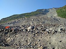
Landslides, also known as landslips, are several forms of mass wasting that may include a wide range of ground movements, such as rockfalls, mudflows, shallow or deep-seated slope failures and debris flows. Landslides occur in a variety of environments, characterized by either steep or gentle slope gradients, from mountain ranges to coastal cliffs or even underwater, in which case they are called submarine landslides.

<span class="mw-page-title-main">Ngawa Tibetan and Qiang Autonomous Prefecture</span> Autonomous prefecture in Sichuan, China

Ngawa Tibetan and Qiang Autonomous Prefecture, also known as Aba, is an autonomous prefecture of northwestern Sichuan, bordering Gansu to the north and northeast and Qinghai to the northwest. Its seat is in Barkam, and it has an area of 83,201 km2 (32,124 sq mi). The population was 895,200 by 2022.

<span class="mw-page-title-main">Sturzstrom</span> Type of landslide

A Sturzstrom or rock avalanche is a large landslide consisting of soil and rock which travels a great horizontal distance compared to its initial vertical drop. Sturzstroms have similarities to the flow of glaciers, mudflows, and lava flows. They flow across land fairly easily, and their mobility increases when volume increases. They have been found on other bodies in the Solar System, including the Moon, Mars, Venus, Io, Callisto, Iapetus, and Phobos.

<span class="mw-page-title-main">Wenchuan County</span> County in Sichuan, China

Wenchuan County is a county in Ngawa Tibetan and Qiang Autonomous Prefecture, Sichuan, China.

<span class="mw-page-title-main">Beichuan Qiang Autonomous County</span> Autonomous County in Sichuan, China

Beichuan Qiang Autonomous County is a county under the jurisdiction of Mianyang City in northern Sichuan province, China. It is located in an ethnically diverse mountainous region of Sichuan. Its Chinese name literally means "North" (bei) "River" (chuan). Its new county seat is located at Yongchang after the 2008 Sichuan earthquake.

<span class="mw-page-title-main">Li County, Sichuan</span> County in Sichuan, China

Li County or Lixian, formerly known as Lifan (理番), is a county in Ngawa Tibetan and Qiang Autonomous Prefecture, Sichuan, China. China National Highway G317 and the Zhaxiling River run through the whole territory.

<span class="mw-page-title-main">Mao County</span> County in Ngawa Prefecture, Sichuan Province, China

Mao County or Maoxian is a county in Ngawa Prefecture, Sichuan Province, China.

<span class="mw-page-title-main">Diexi, Mao County</span> Town in Mao County, Ngawa Prefecture, Sichuan Province, China

Diexi is a town in Mao County, Ngawa Prefecture, Sichuan, China. As of 2000, it has a population of 2,697.

<span class="mw-page-title-main">Diexi Lake</span> Landslide dam-created lake in Mao County, Sichuan

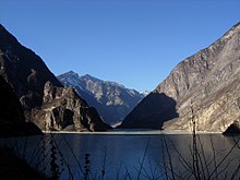
Diexi Lake is a lake in Diexi, Mao County, Sichuan, China.

<span class="mw-page-title-main">Tangjiashan Lake</span> Lake in Peoples Republic of China

Tangjiashan Lake is a landslide dam-created lake on the Jian River, which was formed by the 2008 Sichuan earthquake. Its name comes from the nearby mountain Tangjiashan. On May 24, 2008, the water level rose by 2 metres in a single day, reaching a depth of 23 metres (75 ft), just 29 metres (95 ft) below the barrier level. On June 9, 2008, more than 250,000 people had been evacuated from Mianyang in anticipation of the Tangjiashan Lake dam bursting.

<span class="mw-page-title-main">2008 Sichuan earthquake</span> 8.0 Ms earthquake in China

An earthquake occurred in the province of Sichuan, China at 14:28:01 China Standard Time on May 12, 2008. Measuring at 8.0 Ms, the earthquake's epicenter was located 80 kilometres (50 mi) west-northwest of Chengdu, the provincial capital, with a focal depth of 19 km (12 mi). The earthquake ruptured the fault for over 240 km (150 mi), with surface displacements of several meters. The earthquake was also felt as far away as both Beijing and Shanghai—1,500 and 1,700 km away, respectively—where office buildings swayed with the tremor, as well as Bangkok, Thailand and Hanoi, Vietnam. Strong aftershocks, some exceeding 6 Ms, continued to hit the area up to several months after the main shock, causing further casualties and damage. The earthquake also caused the largest number of geohazards ever recorded, including about 200,000 landslides and more than 800 quake lakes distributed over an area of 110,000 km2 (42,000 sq mi).

On 7 September 2012, a series of earthquakes occurred in Yiliang County, Zhaotong, Yunnan. The two main shocks occurred at 11:19 and 12:16 China Standard Time. The earthquakes left 81 people dead and 821 injured. According to the officials, at least 100,000 people were evacuated and more than 20,000 houses were damaged.

<span class="mw-page-title-main">2013 Lushan earthquake</span> Earthquake in Sichuan, China

The Lushan earthquake or Ya'an earthquake occurred at 08:02 Beijing Time on April 20, 2013. The epicenter was located in Lushan County, Ya'an, Sichuan, about 116 km (72 mi) from Chengdu along the Longmenshan Fault in the same province heavily impacted by the 2008 Sichuan earthquake. The magnitude of the earthquake was placed at Ms 7.0 by China Earthquake Data Center, Ms 7.0 by Russian Academy of Sciences, Mw 7.0 by Geoscience Australia, Mw 6.6 by the United States Geological Survey (USGS), Mw 6.6 by the European Alert System (EMSC) and Mj 6.9 by the Japan Meteorological Agency (JMA). 1,815 aftershocks have been recorded as of 00:00 (UTC+8h) April 22.

<span class="mw-page-title-main">2014 Kangding earthquake</span> Earthquake in China

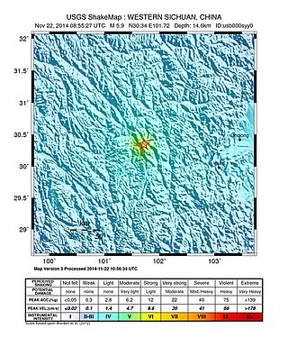
The 2014 Kangding earthquake struck Kangding County, Garzê Tibetan Autonomous Prefecture, Sichuan, China, with a moment magnitude of 5.9 on 22 November. The earthquake killed five and injured 54 people.

The 2017 Jiuzhaigou earthquake occurred on 8 August 2017, in Zhangzha Town, Jiuzhaigou County, Ngawa Prefecture, Sichuan Province, China. The earthquake was registered at Ms 7.0 and killed at least 25 people in the mountainous region of northern Sichuan.

<span class="mw-page-title-main">Bayan Har block</span>

The Bayan Har block or Bayan Kola block is an elongate wedge-shaped block that forms part of the eastern Tibetan Plateau. It is bounded to the southeast by the Longmenshan Fault, a major thrust fault zone, which forms the active tectonic boundary between the plateau and the Sichuan Basin. To the northeast, the boundary is formed by the Kunlun and Minjiang Faults juxtaposing the block against the Eastern Kunlun-Qaidam block and to the southwest by the Xianshuihe fault system forms its boundary with the Qiangtang block. All of these are major left-lateral strike-slip fault zones. The block is currently moving to the southeast relative to the South China block.

The 2021 Luxian earthquake was a damaging seismic event occurring in the early hours of September 16 at 04:33 China Standard Time. The surface wave magnitude (Ms ) 6.0 or moment magnitude (Mw ) 5.4 earthquake struck at a shallow depth of 7.5 km and severe shaking in an area of 4,000 square kilometers was assigned a maximum intensity of VIII on the China seismic intensity scale. Three people were killed and 146 injured when the earthquake struck Lu County, Luzhou, Sichuan Province. At least 36,800 buildings were affected, 7,800 of them seriously damaged or completely destroyed, causing about a quarter of a billion dollars worth of damage.

<span class="mw-page-title-main">2022 Ya'an earthquake</span> Earthquake in Sichuan Province, China

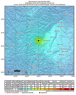
On June 1, 2022, a moment magnitude (Mw ) 5.8 or surface-wave magnitude (Ms ) 6.1 earthquake struck Lushan County in Ya'an, Sichuan Province, China. At least four people were killed and 42 were injured. The earthquake had a maximum intensity of VIII on the China seismic intensity scale, causing damage to many homes and triggering rockslides.

<span class="mw-page-title-main">2022 Luding earthquake</span> Earthquake in China

A Mw 6.7 earthquake struck Luding County in Sichuan province, China on 5 September 2022 at 12:52:19 local time. The epicenter was located 226 km (140 mi) from Chengdu, or 43 km (27 mi) southeast of Kangding. Ninety-three people died, 424 were injured and 24 remained missing. More than 13,000 homes and other infrastructure were damaged or destroyed. It was the largest earthquake to strike the province since 2017.

<span class="mw-page-title-main">2019 Zigong earthquake</span> The earthquake that occurred in Zigong City, China at 13:00 on February 25, 2019.

The 2019 Zigong earthquake occurred in Zigong, Sichuan Province, China, at about 13:00 on February 25, 2019. The epicentre was located in Rongxian County, with a magnitude of Ms 4.9, a focal depth of about 5 km and a maximum intensity of VI. The earthquake killed two people and injured 12 others.

References

  1. 1 2 3 4 5 6 7 8 9 10 11 12 13 Fan, Xuanmei; Xu, Qiang; Scaringi, Gianvito; Dai, Lanxin; Li, Weile; Xiujun, Dong; Zhu, Xing; Pei, Xiangjun; Dai, Keren (10 October 2017). "Failure mechanism and kinematics of the deadly June 24th 2017 Xinmo landslide, Maoxian, Sichuan, China". Landslides. 14 (6): 2129–2146. doi:10.1007/s10346-017-0907-7. S2CID   133681894.
  2. "牵挂·守望·搜救——四川茂县山体垮塌灾害36小时救援纪实". Xinhua News Agency. 26 June 2017.
  3. 1 2 雷兹等 (27 June 2017). "茂县滑坡灾害已有35人确认安全 仍有73人失联". 四川新闻网. 四川新闻. Archived from the original on 14 February 2019. Retrieved 27 June 2017.
  4. 1 2 "专家:历史上两次地震深刻影响茂县山体,监测暂无法完全覆盖" (in Chinese). thepaper.cn. 25 June 2017. Retrieved 25 June 2017.
  5. 1 2 In pictures: Landslide in Sichuan buries over 100 people. (in Chinese). QQ News.
  6. 1 2 Cheng, Genwei; Wang, Xiaodan; He, Xiubin; Fan, Jihui; Fan, Jianrong (September 2008). "Outburst risk of barrier lakes in Sichuan, China". Journal of Mountain Science. 5 (3): 189–193. doi:10.1007/s11629-008-0208-7. S2CID   129231570.
  7. 1 2 3 "Over 100 buried in SW China landslide". Chinadaily. Retrieved 24 June 2017.
  8. 1 2 Dai, Keren; Xu, Qiang; Li, Zhenhong; Tomás, Roberto; Fan, Xuanmei; Dong, Xiujun; Li, Weile; Zhou, Zhiwei; Gou, Jisong (1 March 2019). "Post-disaster assessment of 2017 catastrophic Xinmo landslide (China) by spaceborne SAR interferometry". Landslides. 16 (6): 1189–1199. doi:10.1007/s10346-019-01152-4. hdl: 10045/89476 . ISSN   1612-5118. S2CID   134996836.
  9. "China landslide: more than 100 feared buried as village destroyed". The Sunday Morning Herald. 24 June 2017. Retrieved 24 June 2017.
  10. 1 2 Scaringi, Gianvito; Fan, Xuanmei; Xu, Qiang; Liu, Chun; Ouyang, Chaojun; Domènech, Guillem; Yang, Fan; Dai, Lanxin (21 February 2018). "Some considerations on the use of numerical methods to simulate past landslides and possible new failures: the case of the recent Xinmo landslide (Sichuan, China)". Landslides. 15 (7): 1359–1375. doi:10.1007/s10346-018-0953-9. S2CID   134423415.
  11. 1 2 Xu, Qiang; Fan, Xuanmei; Scaringi, Gianvito (26 January 2018). "Brief communication: Post-seismic landslides, the tough lesson of a catastrophe". Natural Hazards and Earth System Sciences. 18 (1): 397–343. Bibcode:2018NHESS..18..397F. doi: 10.5194/nhess-18-397-2018 .
  12. Intrieri, Emanuele; Raspini, Federico; Fumagalli, Alfio; Lu, Ping; Sara, I; Conte, Del; Farina, Paolo; Allievi, Jacopo; Ferretti, Alessandro (9 November 2017). "The Maoxian landslide as seen from space: detecting precursors of failure with Sentinel-1 data". Landslides. 15: 123–133. doi: 10.1007/s10346-017-0915-7 . hdl: 2158/1102061 .
  13. "China landslide: at least 10 dead and more than 100 feared buried". The Guardian. Reuters. 24 June 2017. Retrieved 25 June 2017.
  14. "临近救援黄金72小时 四川茂县山体垮塌118人失踪". 南洋视界. 25 June 2017.
  15. "Hopes fade in grim search for Xinmo landslide survivors". AlJazeera. 26 June 2017. Retrieved 26 June 2017. Rescue workers in southwestern China have recovered several bodies as hopes fade in the search for 93 other people missing...
  16. Sue-Lin Wong (26 June 2017). "Villagers begin to mourn dead after deadly China landslide". Xinmo, China: Reuters . Retrieved 26 June 2017. Villagers...mourn loved ones lost..with little hope of finding anyone alive after more than 48 hours of fruitless searching... at least 93 people are missing after the landslide...