2020 Kerala floods

Last updated

2020 Kerala floods
IN-KL.svg
Cause Heavy rain
Deforestation and slope alteration
Inadequate drainage
Climate Change
Deaths104 dead, 12 missing, 40 injured
Property damage₹19,000 crore (estimated)
Website www.keralarescue.in

During the heavy rainfall over the monsoon period from 1 June to 18 August 2020, all 14 districts in Kerala were affected with 104 dead and 40 injured. [1] [2] Four districts in Kerala were flooded on 7 August 2020 (Idukki, Wayanad, Malappuram and Kottayam). [3] Major reported incidents in relation to flooding include a landslide in Idukki district on 6 August, claiming 66 lives and an Air India plane crash that caused the death of 21 people. [4] [3] [5] The 2020 flood in Kerala marked the third year in a row of severe monsoon flooding. [6]

Contents

The state is reeling from the destruction: loss of lives, livestock and agriculture and damage to property of approximately ₹19,000 crore. [1] [2] [7] [8] Kerala State Disaster Management Plan was submitted to the Central Government to improve the disaster management capacity of the state. [9] [10]

A flooded road at Angamaly A flooded road at Angamally in 2020.jpg
A flooded road at Angamaly

Introduction

Flood waters in Kerala KeralaFlood000012.jpg
Flood waters in Kerala

Geography and rainfall patterns in Kerala

Monsoon clouds in the Western Ghats region Kerala Monsoon clouds over Western Ghats India.jpg
Monsoon clouds in the Western Ghats region

Kerala is located in the south-west of India and has a tropical climate with high annual rainfall caused by monsoon rain patterns. The majority of its annual rainfall (~80%) occurs during the Southwest Summer Monsoon where warm winds from the Arabian sea cause cloud precipitation over the Western Ghats mountain range. [6] Average annual rainfall in Kerala is around 300 cm and is caused by high numbers of low-to-moderate intensity rainfall days. [11] [12] [13] [6]

Flood stages and warning systems

Thiruvanthapuram's Early Warning System (EWS) plan of 2016, classifies flood alerts as level 1, 2 or 3. The response to each alert level may include notifying local government, broadcasting to the public, activating response teams or evacuating high risk areas. [14] By 9 August 2020, the India Meteorological Department (IMD) had placed 7 districts in Kerala under red alert. [15]

Flood alert levels for districts of Kerala: 9 August 2020
LevelColourResponseDistricts under alert
1YellowStandbyThiruvananthapuram
2OrangePrepare Palakkad, Thrissur, Ernakulam, Kottayam, Pathanamthitta, Kollam districts
3RedEvacuate Alappuzha, Idukki, Malappuram, Wayanad, Kozhikode, Kannur and Kasaragod districts

Analysis of causes

Weather

Kerala experienced 5 low pressure systems [16] during the south west monsoon season in August 2020. This combined with strong winds over the Arabian Sea [17] resulted in cloudbursts [18] which saturated soil structures, further weakening bedrock, overwhelming rivers and drainage systems. [19] Kerala experienced 190% increase in rainfall in the first 10 days of August compared to normal patterns, [3] causing widespread destruction, flooding and landslides. [20] [17] [21] [22] [23] Coastal towns, such as Chellanam, dealt with floods as well as rough seas pushing back on rivers, exacerbating flooding. [24] [25] [26]

Landslides

Tea plantation in Munnar, Idukki, showing the steep gradient of the slopes from rocky outcrops, shola forests to the low-lying tea plantations Munnar tea estate in kerala.jpg
Tea plantation in Munnar, Idukki, showing the steep gradient of the slopes from rocky outcrops, shola forests to the low-lying tea plantations

An analysis of the most significant landslide in the Pettimudi tea estate, Munnar, Idukki, found that the area experienced "extremely heavy rainfall" as classified by the IMD between 3 and 10 August. [5] Rainfall volume peaked at 612mm falling on 6 August [27] with the landslide occurring at 22:45 IST. Categorised as "rain induced debris flow" [5] [27] the landslide was characterised by rapid water flow at a steep gradient, flowing at high velocity from the rocky outcrops through the shola forest collecting loose material along its course to the tea plantation and worker’s living quarters below. Additional landslides occurred in Idukki, Mundakkai, Kakkayam in Kozhikode, Nilambur in Malappuram and Kottayam. [24] [28] [29] [27] [30] [31]

Factors compounding flooding and landslides in Kerala 2020
Deforestation and slope alteration (including agriculture, mining and quarrying) [19] [32] [33]
Rain conservation pits [19] [33]
Insufficient drainage systems [19] [33]
Construction (including buildings and roads) along stream beds, rivers and flood lines [19] [34]
Climate change [6] [35]

Impacts and consequences

Direct impacts

Overview of Kerala district map depicting August 2020 flood-related incidents 2020 Kerala Flooding Overview.jpg
Overview of Kerala district map depicting August 2020 flood-related incidents

The landslide in the Pettimudi tea estate saw significantly heavy rainfall, resulting in excessive flooding and landslide over a 1.2 km tract. Final reports indicate that it destroyed 4 buildings and killed 66 individuals. [5] [36] [37] Majority of the victims were descendants from the Dalits caste system. [38] [39] Meanwhile, low-intensity mudslides and landslides occurred in other regions. [24] [28] [29] [27] [30] [31]

On 7 August, the monsoon rain also caused poor landing conditions at Kerala's Calicut Airport. Due to the COVID-19 pandemic, only repatriation flights were allowed. [40] On the 3rd landing attempt, Air India Express Flight 1344 crashed after it slid down a 9-10.5m slope off the runway, killing both pilots and 19 passengers. [41] [42] [43] [44]

The aircraft type (Boeing 737-8HG) involved in Air India Express Flight 1344's incident Boeing 737-8HG, Air India Express AN1624189.jpg
The aircraft type (Boeing 737-8HG) involved in Air India Express Flight 1344's incident

Indirect impacts

Search and rescue efforts in this area were stalled due to bad weather conditions. [45] The collapse of the Periyavarai bridge, which is the only connectivity for interstate transport between Munnar to Marayur was also an issue. [46] Authorities reported closure of multiple routes including the Pala-Erattupetta road in the Kottayam district where the Meenachil River overflowed into neighbouring towns. [47] Destruction of power lines further affected communication links to the area which caused logistical difficulties in the supply of basic necessities. [48]

Evacuation and relocation efforts led to many residing in temporary relief camps. [24] [49] A mild increase in COVID-19 cases was reported in Chellanam's relief camps, complicating the situation. [26] Agricultural produce was also affected with loss of crops, especially in Kuttanad, and disruptions to transportation caused an increase in food prices. [7] [50] [51]

According to the Ministry of Home Affairs, a total of 1,670 villages were affected, 104 lives lost and 40 injured. Short-term health consequences post-flood include injuries and communicable diseases (e.g. diarrhoea) while long-term impacts includes poor health outcomes due to aspects like malnutrition and mental health issues. [2] [52] [53] [54]

Ministry of Home Affairs Disaster Management Division Situation Report as of 18 August 2020, 1900Hr
Number of AffectedDuring Monsoon Season

(1 June 2020 to 18 August 2020) [1] [2] [8]

DistrictsAll 14 districts in Kerala
VillagesAll 1,670 villages in Kerala
Total Dead/ Missing/ Injured104/ 12/ 40
Houses Damaged220 fully destroyed, 5,190 in parts
Property Damage Cost (Estimated)₹19,000 crore

Response & relief efforts

National

The primary response at the state and national level was to set up relief camps for the flood affectees. A total of 6,300 camps were arranged in the state. [55] In Kollam alone, 51 camps were set up, one in each taluk. [55] The national government also announced ₹200,000 to be distributed among families of casualties of landslides caused by the floods, and ₹50,000 provided to the injured, both through the Prime Minister's National Relief Fund. [56] Kerala's State Disaster Management Authority (KSDMA), police and Indian Air Force actively took part in the rescue operations. [57] To search for missing persons, the National Disaster Response Force (NDRF) was activated, with around 200 personnel. [56] Fire Force and Forest officials also joined the response teams. [58] This task force consisted of 50 Fire Force members specializing in night-time rescue activities. [58]

International

In the aftermath of 2018 Kerala Floods, the Indian government refused international aid for relief efforts. [59] They cited sufficient domestic capacity to deal with the disaster, in line with its policy to accept no foreign aid. [60] It is also seen as a measure to portray the image of India being well equipped to address its needs, [61] and thus little International aid is accepted. [62]

Organizations and individuals

The rugged terrain of Kerala made relief efforts quite challenging for national and international response teams. To fill this gap, local organizations like RIGHTS who were familiar with the geography and had deep local connections rose to the challenge. [63] IAG Kerala and Sphere India assisted in closely monitoring the situation. [56] These grassroots bodies prioritized safeguarding of children and vulnerable populations, putting focus on ensuring their education continues uninterrupted. This was also supplemented by direct cash transfer to their families. [63]

Political and social activists also joined in the efforts in their personal capacities. P.B. Nooh, the District Collector, used his Facebook presence to conduct frequent live sessions to provide updates on relief efforts to the affected population. [55]

Flood management

Kerala is vulnerable to multiple hazards with flooding in 2018, 2019, 2020 and 2021 and 43% of the state prone to landslides. [64] [65] [9] Kerala State Disaster Management Plan outlines the need to reduce hazard risk with mitigation, preparedness, response and recovery. [9] [10]

Four phases of disaster management Disaster management phases.jpg
Four phases of disaster management

Mitigation

Structural measures consist of 81 dams, reservoirs and flood embankments. Non-structural measures include flood hazard mapping and landslide zoning, but larger scale maps are needed to develop effective mitigation plans. [64] [66] River discharge is monitored at 38 river gauging stations by the Central Water Commission. [67] Kerala has 68 rain gauging stations, but the Bureau of Indian Standards recommends 265 to sufficiently monitor rainfall. [65]

Preparedness

IMD monitors weather and Kerala State Emergency Operations Centre (KSEOC) issue colour coded extreme weather alerts. [67] KSDMA provides public alerts through their website and social media platforms. [67] [68] KSEOC is working with the Geological Survey of India, Kerala University and Kerala Development and Innovation Strategic Council to develop a landslide early warning system. [69] [70] In 2020, 14 permanent multipurpose shelters were constructed by KSDMA with funding from the World Bank. [71] [72] Civil defence systems have increased training to support search and rescue efforts and the government has given greater autonomy to local agencies and NGOs. [73] [9] [74]

Response

Operations involve the implementation of disaster event preparations from Rapid Action Force (RAF), NDRF and Kerala Fire and Rescue. [75] [20] [28] [9] During the floods, NDRF set up 6,300 relief camps with COVID-19 categorisation. [55] COVID-19 restrictions resulted in fewer vector-borne diseases. [76] Experts initially warned of increased risk of dengue in 2020, but Kerala registered five dengue deaths, a decrease from 2018 and 2019. [77] [78]

Recovery

Damage and cost estimates are made prior to reconstruction with funding from the State and National Disaster Response Funds. [9] KSDMA published a handbook on constructing flood and landslide resilient housing. [79] Further national and international assistance may be sought by the state. [9]

Recommendations

Critiques of flood response plans

The response to the 2020 floods incorporated lessons from previous years by increasing the use of social media to broadcast flood warnings to the community, releasing water from dams earlier in the monsoon season and establishing evacuation camps for those in high risk areas. [55] Despite improvements being made, Kerala's flood alert system has been heavily critiqued for its inadequacy in responding to flood situations in a timely and coordinated fashion. [82] [11] [83] [84]

Critiques of Kerala's flood response systems
Lack of coordinated state-wide response [84] [83]
Incomplete modelling and mapping of flood-prone areas [84]
Poor correlation between forecasted and actual rain with delayed flood warnings [85] [82]
Poor management of dams (overfilling) and inappropriately timed release of water [86] [87]
Poor regulation of land usage that predisposes to climate change and flooding [33] [32] [19] [82] [18] [88] [87]

See also

Related Research Articles

<span class="mw-page-title-main">Geography of Kerala</span>

Kerala is situated between the Lakshadweep Sea to the west and the Western Ghats to the east. Kerala's coast runs some 590 km in length, while the state itself varies between 35–120 km in width. Geologically, pre-Cambrian and Pleistocene formations comprise the bulk of Kerala's terrain. The topography consists of a hot and wet coastal plain gradually rising in elevation to the high hills and mountains of the Western Ghats. Kerala lies between northern latitude of 8°.17'.30" N and 12°. 47'.40" N and east longitudes 74°.27'.47" E and 77°.37'.12" E. Kerala's climate is mainly wet and maritime tropical, heavily influenced by the seasonal heavy rains brought up by the monsoon.

<span class="mw-page-title-main">National Disaster Response Force</span> Indian specialised force

The National Disaster Response Force (NDRF) is an Indian specialised force constituted under the Disaster Management Act, 2005.

<span class="mw-page-title-main">Cyclone Phet</span> North Indian cyclone in 2010

Very Severe Cyclonic Storm Phet was a powerful tropical cyclone that made landfall on Oman, Western India, and Pakistan. The third named cyclone of the 2010 cyclone season, Phet developed in the Arabian Sea on May 31 to the west of India. With conducive environmental conditions, the storm intensified to reach peak sustained winds of 155 km/h (95 mph) on June 2, based on analysis by the India Meteorological Department (IMD). On the next day, Phet dropped heavy rainfall while moving across eastern Oman, with a peak of 603 mm (23.7 in) in Qurayyat. The rains flooded arid areas and collected into wadis – normally dry river beds. Thousands of homes were wrecked across Oman. There were 24 fatalities in the country, and damage was estimated at US$780 million.

Operation Madad is the name of rescue operations conducted by Indian Navy in various occasions within India. The word "madad" in Hindi means "help".

<span class="mw-page-title-main">2013 North Indian Ocean cyclone season</span> North Indian Ocean tropical cyclone season

The 2013 North Indian Ocean cyclone season was an event in the annual cycle of tropical cyclone formation, in which tropical cyclones formed in the North Indian Ocean and Arabian Sea. The season had no official bounds, but cyclones typically formed between May and December, with the peak from October to November. These dates conventionally delimit the period of each year when most tropical cyclones form in the northern Indian Ocean.

The Great flood of '99 (Malayalam:'തൊണ്ണൂറ്റി ഒമ്പതിലെ വെള്ളപ്പൊക്കം' occurred when the Periyar River in Kerala state of India flooded in the month of July 1924. This happened in the year 1099 ME in the Malayalam Calendar. As the Malayalam Calendar was popular in Kerala, the flood is generally referred to as "The Great flood of "99".The rain continued for about three weeks. Many districts of present-day Kerala were deeply submerged by the flood - from Thrissur, to Ernakulam to Idukki, Kottayam even up to Alappuzha and Kuttanad. A huge mountain called Karinthiri Mala was washed away by this flood and the road to Munnar also went along with it. As the road to Munnar was lost by this flood, a new road from Ernakulam to Munnar became necessary - the present day road from Ernakulam to Munnar was constructed after this. Kundala Valley Railway which was the first monorail system in India was also completely destroyed. Various remnants of the old Railway systems still exist at Munnar.

<span class="mw-page-title-main">Indian Armed Forces and the Jammu and Kashmir floods, 2014</span> Overview of Indian military response to the 2014 Jammu and Kashmir floods

In the wake of heavy monsoon rain and flash floods in Jammu and Kashmir, the Indian Armed Forces were deployed in increasing numbers starting 2 September 2014 to conduct search, rescue, relief, relocation, humanitarian assistance and rehabilitation missions in Jammu and Kashmir. By 18 September, over 298,514 people were rescued from the various parts of Jammu and Kashmir by the Armed forces. The Jammu and Kashmir floods, the worst in a century according to Omar Abdullah, the Chief Minister of Jammu and Kashmir, paralyzed the state government. Omar Abdullah, responding to public criticism, told the media "I had no government" in the first few days following the floods, as "My secretariat, the police headquarters, the control room, fire services, hospitals, all the infrastructure was underwater." Adding "I had no cell phone and no connectivity. I am now starting to track down ministers and officers." The Jammu and Kashmir floods of 2014 have been blamed on heavy rainfall, about 8 inches (200mm) on 4 September alone, on climate change, unplanned and uncontrolled development, encroachment of river banks, lakes, ponds, and massive loss of wet lands, absence of local government flood forecasting system, and poor governance. The Armed Forces humanitarian assistance mission in response to the floods was named Mission Sahayata (assistances). Northern Command's humanitarian assistance to Civil authorities was named 'Operation Megh Rahat'. The Indian Army, Air Force, and the Navy, committed large resources to the assistance mission including over 30,000 troops, 15 engineer task forces, 84 Indian Air Force and Army Aviation Corps fixed wing transport aircraft and helicopters, naval commandos and rescue specialists, and Base Hospital, four field hospitals, over 106 medical detachments. "Operation Megh Rahat", ended on 19 September 2014, but "Operation Sadbhavna", the relief and medical assistance support, according to government press release, will continue in "close synergy with the civil administration and the police".

<span class="mw-page-title-main">2015 North Indian Ocean cyclone season</span> North Indian Ocean tropical cyclone season

The 2015 North Indian Ocean cyclone season was an event in the annual cycle of tropical cyclone formation. The North Indian Ocean cyclone season has no official bounds, but cyclones tend to form between months of April and December, with the peak from May to November. These dates conventionally delimit the period of each year when most tropical cyclones form in the northern Indian Ocean.

This is a list of notable recorded floods that have occurred in India. Floods are the most common natural disaster in India. The heaviest southwest, the Brahmaputra, and other rivers to distend their banks, often flooding surrounding areas.

<span class="mw-page-title-main">Cyclone Roanu</span>

Cyclonic Storm Roanu was a relatively weak tropical cyclone that caused severe flooding in Sri Lanka and Bangladesh during May 2016. It is the first tropical cyclone of the annual cyclone season. Roanu originated from a low-pressure area that formed south of Sri Lanka, which gradually drifted north and intensified into a cyclonic storm on 19 May. However, wind shear and land interaction caused it to weaken slightly, before reintensifying as it accelerated towards the coast of Bangladesh.

<span class="mw-page-title-main">2018 North Indian Ocean cyclone season</span> North Indian Ocean tropical cyclone season

The 2018 North Indian Ocean cyclone season was one of the most active North Indian Ocean cyclone seasons since 1992, with the formation of fourteen depressions and seven cyclones. The North Indian Ocean cyclone season has no official bounds, but cyclones tend to form between April and December, with the two peaks in May and November. These dates conventionally delimit the period of each year when most tropical cyclones form in the northern Indian Ocean.

<span class="mw-page-title-main">2018 Kerala floods</span> Flooding that occurred in Kerala

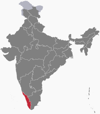
On 16 August 2018, severe floods affected the south Indian state Kerala, due to unusually high rainfall during the monsoon season. It was the worst flood in Kerala in nearly a century. Over 483 people died, and 15 went missing. About a million people were evacuated, mainly from Chengannur, Pandanad, Edanad, Aranmula, Kozhencherry, Ayiroor, Ranni, Pandalam, Kuttanad, Malappuram, Aluva, Chalakudy, Thrissur, Thiruvalla, Eraviperoor, Vallamkulam, North Paravur, Chellanam, Vypin Island and Palakkad. All 14 districts of the state were placed on red alert. According to the Kerala government, one-sixth of the total population of Kerala had been directly affected by the floods and related incidents. The Indian government had declared it a Level 3 Calamity, or "calamity of a severe nature". It is the worst flood in Kerala after the great flood of 99 that took place in 1924.

In mid-March 2019, monsoonal downpours caused widespread flooding and landslides across South Asia.

<span class="mw-page-title-main">2019 Kerala floods</span> Severe flooding due to heavy monsoon rainfall on 8 August 2018

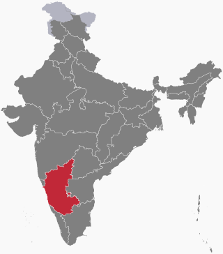
On 8 August 2019, due to heavy rainfall in the monsoon season, severe flood affected Kerala. As a security measure in the prevailing situation of heavy rains, the India Meteorological Department had issued a red alert in the 9 districts in Northern and Central Kerala, orange alert in 3 districts of Central Kerala, and yellow alert in the 2 districts of southern Kerala. Thousands of people have been evacuated to safer places and relief camps. A total of 121 people have died due to rain-related incidents as of 19 August 2019.

The 2019 Indian floods were a series of floods that affected over thirteen states in late July and early August 2019, due to excessive rains. At least 200 people died and about a million people were displaced. Karnataka and Maharashtra were the most severely affected states. People died but many were rescued with the help of the Indian Navy.

<span class="mw-page-title-main">2019 Karnataka floods</span>

On 1 August 2019, first week, due to heavy rainfall in the Monsoon season, severe flood affected the southern Indian State of Karnataka. As a security measure in the prevailing situation of heavy rains, India Meteorological Department issued Red alert to several regions of coastal and malnad regions of Karnataka state.

<span class="mw-page-title-main">2020 Assam floods</span> Natural disaster in Northeast India

2020 Assam floods refers to the significant flood event of the Brahmaputra River in the Indian north-eastern state of Assam and coincided with the COVID-19 pandemic. Initial flooding started in May 2020 due to heavy rainfall affecting 30,000 and destroying crops across 5 districts. As of October 2020 the floods affected over five million people, claiming the lives of 123 people, with an additional 26 deaths due to landslides, 5474 villages were affected and over one hundred and fifty thousand people found refuge in relief camps.

<span class="mw-page-title-main">Cyclone Burevi</span> North Indian Ocean cyclone in 2020

Cyclonic Storm Burevi was a weak tropical cyclone which made landfall in Sri Lanka, becoming the first to do so since a depression in 2014, and brought minimal impact to Southern India in December 2020. The ninth depression and fifth named storm of the 2020 North Indian Ocean cyclone season, Burevi originated from a low-pressure area which formed on November 28. The system gradually became a depression on November 30, with the JTWC issuing a TCFA soon after. The depression then was upgraded into Cyclone Burevi the following day. Burevi slowly intensified reaching its peak intensity on December 2, just before making landfall in Sri Lanka. Burevi then weakened, entering the Gulf of Mannar the next day. Burevi proceeded to dissipate after stalling on December 5.

Operation Sahyog was a rescue mission initiated by the Indian army after several northern districts of Kerala were hit by extreme amounts of rain and landslides. The Indian army deployed its manpower and machinery for rescue operations in regions which were hit severely, mainly at Idukki, Wayanad, Kannur, and Kozhikode. The National Disaster Response Force (NDRF) along with the Army, Naval forces and Air forces carried out the rescue operation.

The 2021 South India floods are a series of floods associated with Depression BOB 05 and a low pressure system that caused widespread disruption across the Indian states of Tamil Nadu, Andhra Pradesh, and the nearby Sri Lanka. The rainfall started on 1 November in Tamil Nadu. The flooding was caused by extremely heavy downpours from BOB 05, killing at least 41 people across India and Sri Lanka.

References

  1. 1 2 3 "Asian Disaster Reduction Center(ADRC)". www.adrc.asia. Retrieved 26 October 2021.
  2. 1 2 3 4 "Situation report as on 18th August' 2020 at 1900 Hrs" (PDF). Reliefweb. Ministry of Home Affairs. Archived (PDF) from the original on 21 August 2020. Retrieved 30 October 2021.
  3. 1 2 3 "Situation Report 11: Flood situation in India, 11th August 2020 - India". ReliefWeb. Retrieved 26 October 2021.
  4. "Kerala Landslide Deaths Rise To 42; Red Alert For 6 Districts". NDTV.com. Retrieved 25 October 2021.
  5. 1 2 3 4 Achu, A. L.; Joseph, Sabu; Aju, C. D.; Mathai, John (1 April 2021). "Preliminary analysis of a catastrophic landslide event on 6 August 2020 at Pettimudi, Kerala State, India". Landslides. 18 (4): 1459–1463. doi:10.1007/s10346-020-01598-x. ISSN   1612-5118. S2CID   231671964.
  6. 1 2 3 4 Vijaykumar, P.; Abhilash, S.; Sreenath, A. V.; Athira, U. N.; Mohanakumar, K.; Mapes, B. E.; Chakrapani, B.; Sahai, A. K.; Niyas, T. N.; Sreejith, O. P. (1 September 2021). "Kerala floods in consecutive years - Its association with mesoscale cloudburst and structural changes in monsoon clouds over the west coast of India". Weather and Climate Extremes. 33: 100339. doi: 10.1016/j.wace.2021.100339 . ISSN   2212-0947.
  7. 1 2 "Mass exodus starts as Kuttanad stares at flooding". The New Indian Express. Retrieved 30 October 2021.
  8. 1 2 Jacob, Jeemon (21 October 2021). "How Kerala managed its reservoirs in 2021 floods". India Today. Retrieved 30 October 2021.
  9. 1 2 3 4 5 6 7 "Kerala State Disaster Management Plan 2016" (PDF). Kerala State Disaster Management Authority Department of Revenue and Disaster Management Government of Kerala. Retrieved 26 October 2021.
  10. 1 2 Wilson, Duncan T.; Hawe, Glenn I.; Coates, Graham; Crouch, Roger S. (1 November 2013). "A multi-objective combinatorial model of casualty processing in major incident response". European Journal of Operational Research. 230 (3): 643–655. doi: 10.1016/j.ejor.2013.04.040 . ISSN   0377-2217.
  11. 1 2 Varghese, Nikhil (30 August 2019). "Capacities and Gaps in Early Warning Systems: Kerala Floods".{{cite journal}}: Cite journal requires |journal= (help)
  12. Francis, P. A.; Gadgil, Sulochana (1 November 2006). "Intense rainfall events over the west coast of India". Meteorology and Atmospheric Physics. 94 (1): 27–42. Bibcode:2006MAP....94...27F. doi:10.1007/s00703-005-0167-2. ISSN   1436-5065. S2CID   15402094.
  13. Tawde, Sayli A.; Singh, Charu (2015). "Investigation of orographic features influencing spatial distribution of rainfall over the Western Ghats of India using satellite data". International Journal of Climatology. 35 (9): 2280–2293. Bibcode:2015IJCli..35.2280T. doi:10.1002/joc.4146. ISSN   1097-0088. S2CID   128929261.
  14. "Early Warning System Plan" (PDF). Municipal Corporation of Thiruvananthapuram, Kerala. 2016. Archived (PDF) from the original on 7 June 2021. Retrieved 25 October 2021.
  15. "Kerala to receive heavy rainfall in next 24 hours; red alert in 7 districts". The New Indian Express. Retrieved 26 October 2021.
  16. "Weather Status for August, 2020 & its verification and Outlook for September, 2020". pib.gov.in. Archived from the original on 30 October 2021. Retrieved 26 October 2021.
  17. 1 2 "Kerala faces floods for third consecutive year". www.downtoearth.org.in. Retrieved 26 October 2021.
  18. 1 2 "What is triggering regular flood misery in Kerala?". gulfnews.com. Retrieved 26 October 2021.
  19. 1 2 3 4 5 6 Wadhawan, Sudesh Kumar; Singh, Balmukund; Ramesh, Maneesha Vinodini (1 September 2020). "Causative factors of landslides 2019: case study in Malappuram and Wayanad districts of Kerala, India". Landslides. 17 (11): 2689–2697. doi:10.1007/s10346-020-01520-5. ISSN   1612-510X. S2CID   221401403.
  20. 1 2 Raman, Giji K. (8 August 2020). "Kerala rains 2020 | Search for bodies resumes at site of Idukki landslide". The Hindu. ISSN   0971-751X . Retrieved 26 October 2021.
  21. Joseph, Alphonse (7 August 2020). "Kerala rains: Wayanad faces flood-like situation in state, IMD issues red alert in Malappuram". Archived from the original on 7 August 2020. Retrieved 26 October 2021.
  22. "Rivers in full spate, one killed, red alert sounded in Malappuram". The New Indian Express. Retrieved 26 October 2021.
  23. "Torrential rains in Kerala's Kottayam bring life to standstill, several regions fear flooding". The New Indian Express. Retrieved 26 October 2021.
  24. 1 2 3 4 "Have floods and landslides become a routine August affair in Kerala". OnManorama. Retrieved 26 October 2021.
  25. "Kerala Rains: Pamba dam shutters lifted, water level reaches 136ft at Mullaperiyar". OnManorama. Retrieved 26 October 2021.
  26. 1 2 EJ, Ashfaque. "This was a man-made disaster: Residents of Kerala's flood-ravaged Chellanam village". The Caravan. Retrieved 26 October 2021.
  27. 1 2 3 4 "Pettimudi landslide: Geological Survey of India submits report. - Document - Gale General OneFile". go.gale.com. Retrieved 26 October 2021.
  28. 1 2 3 Manoj, E. m (7 August 2020). "Rain continues to wreak havoc in Wayanad". The Hindu. ISSN   0971-751X . Retrieved 26 October 2021.
  29. 1 2 "India – Torrential Rains Trigger Deadly Landslide in Kerala – FloodList". floodlist.com. Retrieved 26 October 2021.
  30. 1 2 Lobo, Shalini (9 August 2020). "Church turns into relief camp as rain, landslide wreak havoc in Kerala's Kakkayam hills". India Today. Retrieved 26 October 2021.
  31. 1 2 "Deadly landslides are becoming Kerala's new reality every monsoon". Mongabay-India. 11 August 2020. Retrieved 26 October 2021.
  32. 1 2 Krishnaswamy, Jagdish; Bonell, Michael; Venkatesh, Basappa; Purandara, Bekal K.; Lele, Sharachchandra; Kiran, M.C.; Reddy, Veerabasawant; Badiger, Shrinivas; Rakesh, K.N. (2012). "The rain–runoff response of tropical humid forest ecosystems to use and reforestation in the Western Ghats of India". Journal of Hydrology. 472–473: 216–237. Bibcode:2012JHyd..472..216K. doi:10.1016/j.jhydrol.2012.09.016.
  33. 1 2 3 4 Sajinkumar, K. S.; Sankar, G.; Rani, V. R.; Sundarajan, P. (2014). "Effect of quarrying on the slope stability in Banasuramala: an offshoot valley of Western Ghats, Kerala, India". Environmental Earth Sciences. 72 (7): 2333–2344. doi:10.1007/s12665-014-3143-7. ISSN   1866-6280. S2CID   129249426.
  34. Parvathy, Sethu; Thomas, Reeba (1 March 2021). "Impact of urbanization on flooding in chalakudy river". IOP Conference Series: Materials Science and Engineering. 1114 (1): 012025. Bibcode:2021MS&E.1114a2025P. doi: 10.1088/1757-899X/1114/1/012025 . ISSN   1757-8981. S2CID   234811375.
  35. Hunt, Kieran M. R.; Menon, Arathy (1 February 2020). "The 2018 Kerala floods: a climate change perspective". Climate Dynamics. 54 (3): 2433–2446. Bibcode:2020ClDy...54.2433H. doi: 10.1007/s00382-020-05123-7 . ISSN   1432-0894. S2CID   210715907.
  36. Regan, Helen; Gupta, Swati. "Monsoon rains trigger landslide in India, killing at least 43 people". CNN. Retrieved 26 October 2021.
  37. "India tea plantation landslide death toll climbs to 43". www.aljazeera.com. Retrieved 26 October 2021.
  38. George, Alphonsa P. "One year of Pettimudi landslide; a scar yet to be healed". Mathrubhumi. Retrieved 30 October 2021.
  39. "Tea plantation workers bear brunt of Idukki landslide; activist says inadequate housing compounded woes". Firstpost. 11 August 2020. Retrieved 30 October 2021.
  40. M.K, Nidheesh (7 May 2020). "Covid-19: Kerala ready to be the first stop of Vande Bharat mission". mint. Retrieved 30 October 2021.
  41. "Eighteen dead and over 120 injured after plane crash in India". euronews. 7 August 2020. Retrieved 26 October 2021.
  42. "IX 1344 incident at Kozhikode - UPDATES". Expressions The Official Blog of Air India Express. 7 August 2020. Archived from the original on 23 August 2020. Retrieved 29 October 2020.
  43. "Pilot Error Led to Air India Crash at Kozhikode Last Year". Travel Radar. 12 September 2021. Retrieved 30 October 2021.
  44. "Kozhikode: Air India Plane Crash Toll Climbs to 21 as One More Passenger Succumbs to Injuries". News18. 24 August 2020. Retrieved 29 October 2021.
  45. "Rescue ops at Idukki landslide site to continue overnight, says Kerala CM". Hindustan Times. 7 August 2020. Retrieved 30 October 2021.
  46. Nambudiri, Sudha (6 August 2020). "Kerala rains: Wayanad, Kozhikode remain on red alert; bridge collapses, rising river levels reported". The Times of India. Retrieved 30 October 2021.
  47. "Rain havoc in Kerala: Red alert in Idukki, Thrissur, Palakkad and Wayanad". OnManorama. Retrieved 26 October 2021.
  48. "Landslide in Kerala Updates: Rescue ops to continue overnight, says CM Pinarayi Vijayan; NDRF team arrives at spot". Firstpost. 8 August 2020. Retrieved 26 October 2021.
  49. Sreemol, T. C. (6 August 2020). "Kerala: Officials make plan to evacuate over 15,000 people". The Times of India. Retrieved 30 October 2021.
  50. N, Smitha (22 October 2020). "Steep increase in price of veggies in Kerala". Deccan Chronicle. Retrieved 26 October 2021.
  51. Nambudiri, Sudha (6 August 2020). "Kerala: IMD issues red alert for Idukki and Wayanad". The Times of India. Retrieved 26 October 2021.
  52. "Diarrhoea in children under 5 more prevalent in rural India: NFHS-5". www.downtoearth.org.in. Retrieved 31 October 2021.
  53. "From Kerala to Gujarat, malnutrition takes reverse course in key states, finds government survey". The Financial Express. 14 December 2020. Retrieved 31 October 2021.
  54. "After the Flood: A Post-disaster Health Crisis" (PDF). The Royal Society of Tropical Medicine and Hygiene. October 2020.
  55. 1 2 3 4 5 "2018 vs 2020: How Kerala was Better Prepared for The Floods & Saved Lives". The Better India. 10 August 2020. Retrieved 28 October 2021.
  56. 1 2 3 "Situation Report 11: Floods and Landslide Situation in India" (PDF). Reliefweb. 11 August 2021. Archived (PDF) from the original on 25 October 2021. Retrieved 28 October 2021.
  57. "Handbook on Disaster Management: Emergency Operation Centers & Emergency Support Functions Plan Kerala" (PDF). Kerala State Disaster Management Authority. October 2016. Archived (PDF) from the original on 30 September 2020. Retrieved 30 October 2021.
  58. 1 2 "Rescue ops at Idukki landslide site to continue overnight, says Kerala CM". Hindustan Times. 7 August 2020. Retrieved 28 October 2021.
  59. "India refuses international aid for Kerala flood relief". Deutsche Welle. 23 August 2018. Retrieved 28 October 2021.
  60. "Kerala floods: Centre firm on no-aid policy but may allow funds under 'schemes'". Hindustan Times. 22 August 2018. Retrieved 28 October 2021.
  61. "India refuses international aid for Kerala flood relief". Deutsch Welle. 23 August 2018. Retrieved 31 October 2021.
  62. Mohan, Geeta (22 August 2020). "India declines foreign aid for Kerala flood relief". India Today. Retrieved 31 October 2021.
  63. 1 2 "'RIGHTS' Kerala Flood Relief". Hindus for Human Rights. Retrieved 28 October 2021.
  64. 1 2 3 4 Srija, P.; Nithin, G.; Chaithanya, V.; Sushma, S.; Sridevi, M. (15 August 2021). "A Case Study on Kerala Floods" (PDF). International Journal of Current Engineering and Technology (9): 26–31. Retrieved 26 October 2021.
  65. 1 2 Guptan, Mahesh. "A sea change in weather pattern behind excess rains, frequent cyclones threatening Kerala". OnManorama. Retrieved 26 October 2021.
  66. S. K., Sudhi (21 October 2021). "Analysis | Kerala yet to get its basics right on tackling natural disasters". The Hindu. Retrieved 26 October 2021.
  67. 1 2 3 "Kerala State Disaster Management Authority". KSDMA. Retrieved 26 October 2021.
  68. Krishnakumar, G. (23 October 2021). "Kerala flash floods were due to excessive rainfall, says expert". The Hindu. Retrieved 26 October 2021.
  69. "Landslide Early Warning – Kerala State Disaster Management Authority". KSDMA. Retrieved 26 October 2021.
  70. Tripathi, Sibu (18 August 2020). "India is developing landslide early warning system: How does it work and why it's a challenging task". India Today. Retrieved 26 October 2021.
  71. "Three multipurpose shelters before monsoon". The Hindu. 29 February 2020. Retrieved 26 October 2021.
  72. "NCRMP – Kerala – Kerala State Disaster Management Authority". KSDMA. Retrieved 26 October 2021.
  73. "Analysis | Kerala yet to get its basics right on tackling natural disasters". The Hindu. 21 October 2021. Retrieved 26 October 2021.
  74. "Report of Webinar 'COVID 19 & Disaster Preparedness 2 for Inter Agency Group on 19th August 2020" (PDF). Kerala State Disaster Management Authority. Archived (PDF) from the original on 2 June 2021.
  75. "Department of Fire and Rescue Services | Kannur District , Government of kerala | India" . Retrieved 26 October 2021.
  76. Viswanathan, M. "COVID, flood and monsoon diseases: Myriad challenges lie ahead for Kerala". The New Indian Express. Retrieved 31 October 2021.
  77. Maya, C. (8 December 2019). "Experts fear Kerala is in for a major dengue outbreak in 2020". The Hindu. Retrieved 31 October 2021.
  78. "Dengue/DHF Situation in India". National Vector Borne Disease Control Programme. Ministry of Health & Family Welfare, Government of India. Retrieved 31 October 2021.
  79. "Flood-resistant housing attracts attention in Kerala". Mongabay-India. 24 July 2019. Retrieved 26 October 2021.
  80. Hussain, Shebina (15 December 2020). "Planning Challenges and Implications of Sponge City Concept in Managing Urban Floods in Kerala" (PDF). International Journal of Research in Engineering and Science. 8 (12): 29–35. Retrieved 28 October 2021.
  81. Murali, Janaki (23 August 2018). "Kerala, After The Flood: Tendency to back development despite warning from ecologists creates ground for future disasters". Firstpost. First Post. Retrieved 28 October 2021.
  82. 1 2 3 Varughese, Anil; Purushothaman, Chithra (2021). "Climate Change and Public Health in India: The 2018 Kerala Floods". World Medical & Health Policy. 13 (1): 16–35. doi:10.1002/wmh3.429. S2CID   233839676.
  83. 1 2 "Despite repeated natural calamities during monsoon, Kerala yet to set up flood warning system". The New Indian Express. Retrieved 24 October 2021.
  84. 1 2 3 Vignessh (13 August 2020). "Prone to floods and landslides, Kerala has no warning system to avert tragedies". The Federal. Retrieved 26 October 2021.
  85. "Kerala Floods – 2018 (1 August to 30 August 2018)" (PDF). 13 September 2018. Archived (PDF) from the original on 3 June 2021. Retrieved 26 October 2021.
  86. "Kerala floods: Poor dam management behind disasters, experts say". Hindustan Times. 25 August 2018. Retrieved 26 October 2021.
  87. 1 2 Padma, T (2018). "Mining and dams exacerbated devastating Kerala floods". Nature. 561 (7721): 13–14. Bibcode:2018Natur.561...13P. doi:10.1038/d41586-018-06145-2. PMID   30181636. S2CID   52157297.
  88. "Quarrying in Kerala needs more monitoring, indicates environmental panel". Mongabay-India. 30 November 2020. Retrieved 26 October 2021.