2024 Pacific typhoon season

Last updated

2024 Pacific typhoon season
Ewiniar 2024 path.png
Season summary map
Seasonal boundaries
First system formedMay 22, 2024
Last system dissipatedSeason ongoing
Strongest storm
Name Ewiniar
  Maximum winds130 km/h (80 mph)
(10-minute sustained)
  Lowest pressure980 hPa (mbar)
Seasonal statistics
Total depressions2
Total storms1
Typhoons1
Super typhoons0 (unofficial) [nb 1]
Total fatalities7
Total damage$14.8 million (2024 USD)
Related articles
Pacific typhoon seasons
2022, 2023, 2024, 2025 , 2026

The 2024 Pacific typhoon season is the fifth-latest start for a Pacific typhoon season since reliable records began. It is an ongoing event in the annual cycle of tropical cyclone formation in the western Pacific Ocean. The season runs throughout 2024, though most tropical cyclones typically develop between May and October.

Contents

The scope of this article is limited to the Pacific Ocean to the north of the equator between 100°E and 180th meridian. Within the northwestern Pacific Ocean, there are two separate agencies that assign names to tropical cyclones which can often result in a cyclone having two names. The Japan Meteorological Agency  (JMA) [nb 2] will name a tropical cyclone if it has 10-minute sustained wind speeds of at least 65 km/h (40 mph) anywhere in the basin. The Philippine Atmospheric, Geophysical and Astronomical Services Administration  (PAGASA) assigns names to tropical cyclones which move into or form as a tropical depression in the Philippine Area of Responsibility (PAR), located between 135°E and 115°E and between 5°N–25°N, regardless of whether or not a tropical cyclone has already been given a name by the JMA. Tropical depressions that are monitored by the United States' Joint Typhoon Warning Center  (JTWC) [nb 3] [nb 1] are given a number with a "W" suffix.

Seasonal forecasts

TSR forecasts
Date
Tropical
storms
Total
Typhoons
Intense
TCs
ACERef.
Average (1991–2020)25.516.09.3301 [3]
May 7, 202425157225 [3]
2024 seasonForecast
Center
Tropical
cyclones
Tropical
storms
TyphoonsRef.
Actual activity:JMA211
Actual activity:JTWC111
Actual activity:PAGASA111

During the year, several national meteorological services and scientific agencies forecast how many tropical cyclones, tropical storms, and typhoons will form during a season and/or how many tropical cyclones will affect a particular country. These agencies included the Tropical Storm Risk (TSR) Consortium of University College London, PAGASA and Taiwan's Central Weather Bureau.

Tropical Storm Risk (TSR) released their first forecast on May 7, predicting below average activity with 25 named storms, 15 typhoons and 7 intense typhoons. This was primarily due to the dominant El Niño event at the time, which was expected to transition into a weak or moderate La Niña by mid-2024. [3]

Seasonal summary

Typhoon Ewiniar (2024)2024 Pacific typhoon season

The Pacific typhoon season began abnormally late, with no systems forming for five months until May 22, when a tropical storm named Ewiniar formed southeast of Palau, marking it as the fifth-latest start of a Pacific typhoon season since reliable records began. [4] Ewiniar went straight to the Philippines to make nine landfalls in Homonhon Island; Giporlos, Eastern Samar; Basiao Island; Cagduyong Island; Batuan, Masbate; Masbate City; Torrijos, Marinduque; Lucena, Quezon and Patnanungan. It began to move over the warm tropical waters of Lamon Bay, where the JTWC and the JMA upgraded Ewiniar into a minimal typhoon.

Ewiniar began to deteriorate as it moved away from land due to its topographical effects from the island. On May 30, another tropical depression formed southeast of Haikou, China.

Systems

Typhoon Ewiniar (Aghon)

Typhoon (JMA)
Category 2 typhoon (SSHWS)
Ewiniar 2024-05-26 2310Z.jpg   Ewiniar 2024 path.png
DurationMay 22 – May 30
Peak intensity130 km/h (80 mph) (10-min);
980  hPa  (mbar)

On May 21, the Joint Typhoon Warning Center (JTWC) began to monitor an area of atmospheric convection 441 km (274 mi) southeast of Palau, noting that the system was moving northwestward towards an environment favorable for tropical cyclogenesis, characterized by sea surface temperatures of 29–30 °C (84–86 °F), low vertical wind shear, and moderate to strong outflow. [5] The JTWC subsequently issued a Tropical Cyclone Formation Alert (TCFA) on the following day as the disturbance developed rainbands wrapping from the southwest. [6] At 18:00 UTC, the Japan Meteorological Agency (JMA) recognized the system as a tropical depression. [7] Early on May 23, the depression entered the Philippine Area of Responsibility. [8] In the early morning of May 24, Philippine Atmospheric, Geophysical, and Astronomical Services Administration upgraded the system from a low-pressure area into a depression, assigning it the local name Aghon. [9] At 18:00 UTC, the JTWC upgraded the system to Tropical Depression 01W based on surface observations from Guiuan. [10]

Aghon made landfall over Homonhon Island and subsequently Giporlos, Eastern Samar in the early morning of May 25 (PHT). [11] In the evening, it made five more landfalls over Basiao and Cagduyong Islands of Catbalogan; Batuan in Ticao Island; Masbate City; and Torrijos, Marinduque. [12] At 12:00 UTC, the JTWC reported that the tropical depression had intensified into a tropical storm while it was still in Tayabas Bay. [13] The JMA then classified the system as a tropical storm the following day, assigning it the name Ewiniar. [14] In the morning of May 26 (PHT), the storm made its eighth landfall over Lucena, Quezon in Luzon island. [12] The JTWC upgraded Ewiniar into a minimal-equivalent typhoon after satellite imagery showed that its eye feature was developing over the warm waters of Lamon Bay. [15] [16] In the evening, the storm made its ninth landfall over Patnanungan in the Polillo Islands. [17] The next day, the JMA upgraded Ewiniar into a typhoon. [18] The typhoon left the PAR on May 29 and continued to deteriorate due to subsidence around the mid-latitude. [19] [20] Shortly afterwards, it passed directly over the island of Minamidaitōjima. [21] On the following day, Ewiniar transitioned into an extratropical cyclone south-southwest of Yokosuka, Japan. [22] [23]

Eight people were injured and around 36,143 others were directly impacted by Ewiniar in the Philippines. [24] [25] Seven people, including an infant, died in Quezon. [26] A falling tree destroyed two vehicles in Taytay, Rizal. [27] Nineteen houses were washed away by strong waves in Tanza, Cavite. [28] Flooding and power outages occurred in Quezon and Laguna Provinces, while a barge ran aground in Mauban. [29] [30] Despite not making landfall in Japan, intense winds occurred in Kitadaitō, Okinawa. A maximum wind gust of 89 km/h (55 mph) was recorded. [31] Agricultural damage in the Philippines totalled ₱57.5 million ( US$ 1.17 million). [32] Damage to infrastructure was valued a ₱670.22 million ( US$ 13.61 million) for a total of ₱727.72 million ( US$ 14.78 million). [33]

Tropical Depression

17°00′N112°06′E / 17.0°N 112.1°E / 17.0; 112.1 (Tropical Depression)
201 nautical miles (370 km; 230 mi) SE of Haikou, China

Notes

  1. 1 2 A super typhoon is an unofficial category used by the Joint Typhoon Warning Center (JTWC) for a typhoon with winds of at least 240 km/h (150 mph). [2]
  2. The Japan Meteorological Agency is the official Regional Specialized Meteorological Center for the western Pacific Ocean.
  3. The Joint Typhoon Warning Center is a joint United States Navy  United States Air Force task force that issues tropical cyclone warnings for the western Pacific Ocean and other regions. [1]

Related Research Articles

<span class="mw-page-title-main">Timeline of the 2005 Pacific typhoon season</span>

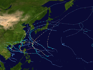
This timeline documents all of the events of the 2005 Pacific typhoon season, the period that tropical cyclones formed in the Western Pacific Ocean during the year. The scope of this article is limited to the Pacific Ocean, north of the equator between 100°E and the International Date Line. Tropical depressions that form in the basin were given a number with a "W" suffix by the United States' Joint Typhoon Warning Center (JTWC). If a depression intensified into a tropical storm, it would be assigned a name by the Japan Meteorological Agency (JMA). In addition, the Philippine Atmospheric, Geophysical and Astronomical Services Administration (PAGASA) assigned names to tropical cyclones which were in their area of responsibility.

<span class="mw-page-title-main">2008 Pacific typhoon season</span>

The 2008 Pacific typhoon season was a below average season which featured 22 named storms, eleven typhoons, and two super typhoons. The season had no official bounds; it ran year-round in 2008, but most tropical cyclones tend to form in the northwestern Pacific Ocean between May and November. These dates conventionally delimit the period of each year when most tropical cyclones form in the northwestern Pacific Ocean.

<span class="mw-page-title-main">2012 Pacific typhoon season</span>

The 2012 Pacific typhoon season was a slightly above average season that produced 25 named storms, fourteen typhoons, and four intense typhoons. It was a destructive and the second consecutive year to be the deadliest season, primarily due to Typhoon Bopha which killed 1,901 people in the Philippines. It was an event in the annual cycle of tropical cyclone formation, in which tropical cyclones form in the western Pacific Ocean. The season ran throughout 2012, though most tropical cyclones typically develop between May and October. The season's first named storm, Pakhar, developed on March 28, while the season's last named storm, Wukong, dissipated on December 29. The season's first typhoon, Guchol, reached typhoon status on June 15, and became the first super typhoon of the year on June 17.

<span class="mw-page-title-main">2010 Pacific typhoon season</span>

The 2010 Pacific typhoon season, with 14 named storms, was the least active Pacific typhoon season on record. Seven of them strengthened into typhoons while one reached super typhoon intensity. All of the 14 named storms developed west of 150°E.

<span class="mw-page-title-main">Timeline of the 2009 Pacific typhoon season</span>

This timeline documents all of the events of the 2009 Pacific typhoon season which was the period that tropical cyclones formed in the Western Pacific Ocean during 2009, with most of the tropical cyclones forming between May and November. The scope of this article is limited to the Pacific Ocean, north of the equator between 100°E and the International Date Line. Tropical storms that form in the entire Western Pacific basin are assigned a name by the Japan Meteorological Agency. Tropical depressions that form in this basin are given a number with a "W" suffix by the United States' Joint Typhoon Warning Center. In addition, the Philippine Atmospheric, Geophysical and Astronomical Services Administration (PAGASA) assigns names to tropical cyclones that enter or form in the Philippine area of responsibility. These names, however, are not in common use outside of the Philippines.

<span class="mw-page-title-main">Typhoon Kujira (2009)</span> Pacific typhoon in 2009

Typhoon Kujira, known in the Philippines as Typhoon Dante, was first reported by the Joint Typhoon Warning Center (JTWC) on April 28. It was the fourth depression and the first typhoon of the season. The disturbance dissipated later that day however it regenerated early on April 30 within the southern islands of Luzon. It was then designated as a Tropical Depression during the next morning by the Philippine Atmospheric, Geophysical and Astronomical Services Administration (PAGASA) and the Japan Meteorological Agency (JMA), with PAGASA assigning the name Dante to the depression. However the JTWC did not designate the system as a depression until early on May 2 which was after the depression had made landfall on the Philippines. Later that day Dante was upgraded to a Tropical Storm and was named as Kujira by the JMA. The cyclone started to rapidly intensify becoming a typhoon early on May 4, and then reaching its peak winds of 155 km/h (100 mph) (10-min), 215 km/h (135 mph) (1-min) later that day after a small clear eye had developed.

<span class="mw-page-title-main">2014 Pacific typhoon season</span>

The 2014 Pacific typhoon season was a slightly below average season in terms of named storms, but featured the highest amount of Category 5 typhoons since 1997. This was mainly due to a developing El Niño that favors multiple powerful storms to form in the basin. The season formed twenty-three tropical storms, eleven typhoons, eight super typhoons, and seven Category 5 typhoons. The season's peak months August and September saw minimal activity caused by an unusually strong and a persistent suppressing phase of the Madden–Julian oscillation (MJO). The season ran throughout 2014, though most tropical cyclones typically develop between May and October. The season began with the development of Tropical Storm Lingling on January 18, and ended after Tropical Storm Jangmi which dissipated on January 1 of the next year.

<span class="mw-page-title-main">2017 Pacific typhoon season</span>

The 2017 Pacific typhoon season was a below-average season in terms of accumulated cyclone energy and the number of typhoons and super typhoons, and the first since the 1977 season to not produce a Category 5-equivalent typhoon on the Saffir–Simpson scale. The season produced a total of 27 named storms, 11 typhoons, and only two super typhoons, making it an average season in terms of storm numbers. It was an event in the annual cycle of tropical cyclone formation, in which tropical cyclones form in the western Pacific Ocean. The season runs throughout 2017, though most tropical cyclones typically develop between May and October. The season's first named storm, Muifa, developed on April 25, while the season's last named storm, Tembin, dissipated on December 26. This season also featured the latest occurrence of the first typhoon of the year since 1998, with Noru reaching this intensity on July 23.

<span class="mw-page-title-main">2018 Pacific typhoon season</span>

The 2018 Pacific typhoon season was at the time, the costliest Pacific typhoon season on record, until the record was beaten by the following year. The season was well above-average, producing twenty-nine storms, thirteen typhoons, seven super typhoons and six Category 5 tropical cyclones. The season ran throughout 2018, though most tropical cyclones typically develop between May and October. The season's first named storm, Bolaven, developed on January 3, while the season's last named storm, Man-yi, dissipated on November 28. The season's first typhoon, Jelawat, reached typhoon status on March 29, and became the first super typhoon of the year on the next day.

<span class="mw-page-title-main">2020 Pacific typhoon season</span>

The 2020 Pacific typhoon season was the first of an ongoing series of below average Pacific typhoon seasons, and became the first with below-average tropical cyclone activity since 2014, with 23 named storms, 10 of which became typhoons and only 2 became super typhoons. This low activity was a consequence of La Niña that persisted from the summer of the year. It had the sixth-latest start in the basin on record, slightly behind 1973, and was the first to start that late since 2016. The first half of the season was unusually inactive, with only four systems, two named storms and one typhoon at the end of July. Additionally, the JTWC recorded no tropical cyclone development in the month of July, the first such occurrence since reliable records began. The season's first named tropical cyclone, Vongfong, developed on May 8, while the season's last named tropical cyclone, Krovanh, dissipated on December 24. However, the season's last system was an unnamed tropical depression which dissipated on December 29.

<span class="mw-page-title-main">Timeline of the 2013 Pacific typhoon season</span>

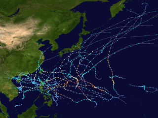
Most of the tropical cyclones of the 2013 Pacific typhoon season formed between May and November of that year. The scope of this article is the Pacific Ocean north of the equator, between 100°E and the International Date Line. Tropical storms which form in the Western Pacific basin are assigned a name by the Japan Meteorological Agency (JMA). Tropical depressions forming in this basin are given a number with a "W" suffix by the United States' Joint Typhoon Warning Center (JTWC). The Philippine Atmospheric, Geophysical and Astronomical Services Administration (PAGASA) assigns names to tropical cyclones that enter or form in the Philippine area of responsibility, but these names are not in common use outside the Philippines.

<span class="mw-page-title-main">Timeline of the 2011 Pacific typhoon season</span>

This timeline documents all of the events of the 2011 Pacific typhoon season, the period that tropical cyclones formed in the Western Pacific Ocean in 2011. Most of the tropical cyclones formed between May and November 2011. The scope of this article is limited to the Pacific Ocean, north of the equator between 100°E and the International Date Line. Tropical storms that form in the entire Western Pacific basin are assigned a name by the Japan Meteorological Agency (JMA). Tropical depressions that form in this basin are given a number with a "W" suffix by the United States' Joint Typhoon Warning Center (JTWC). In addition, the Philippine Atmospheric, Geophysical and Astronomical Services Administration (PAGASA) assigns names to tropical cyclones that enter or form in the Philippine area of responsibility. These names, however, are not in common use outside of the Philippines.

<span class="mw-page-title-main">Timeline of the 2014 Pacific typhoon season</span>

This timeline documents all of the events of the 2014 Pacific typhoon season. Most of the tropical cyclones forming between May and November. The scope of this article is limited to the Pacific Ocean, north of the equator between 100°E and the International Date Line. Tropical storms that form in the entire Western Pacific basin are assigned a name by the Japan Meteorological Agency. Tropical depressions that form in this basin are given a number with a "W" suffix by the United States' Joint Typhoon Warning Center. In addition, the Philippine Atmospheric, Geophysical and Astronomical Services Administration (PAGASA) assigns names to tropical cyclones that enter or form in the Philippine area of responsibility. These names, however, are not in common use outside of the Philippines.

<span class="mw-page-title-main">Tropical Storm Lingling (2014)</span> Pacific tropical storm in 2014

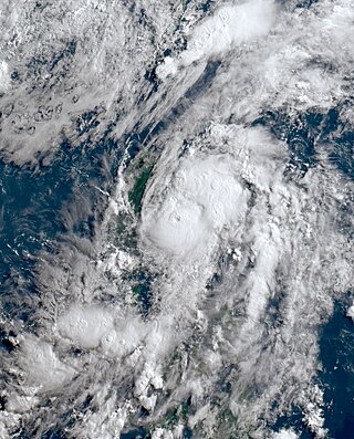
Tropical Storm Lingling, known in the Philippines as Tropical Depression Agaton, was a weak but deadly tropical cyclone that affected the Philippines in January 2014. The first named storm of the annual typhoon season, this early-season cyclone remained very disorganized throughout its lifespan. Lingling was the first major natural disaster in the Philippines after Typhoon Haiyan just two months earlier, as it caused widespread landslide incidents and floods in Mindanao, resulting in 70 deaths and damage amounting to over 566 million pesos on the island.

<span class="mw-page-title-main">Timeline of the 2012 Pacific typhoon season</span>

This timeline documents all of the events of the 2012 Pacific typhoon season. The scope of this article is limited to the Pacific Ocean, north of the equator between 100°E and the International Date Line. During the season, 34 systems were designated as tropical depressions by either the Japan Meteorological Agency (JMA), the Philippine Atmospheric, Geophysical and Astronomical Services Administration (PAGASA), the Joint Typhoon Warning Center (JTWC), or other National Meteorological and Hydrological Services such as the China Meteorological Administration and the Hong Kong Observatory. Since the JMA runs the Regional Specialized Meteorological Centre (RSMC) for the Western Pacific, they assigned names to tropical depressions which developed into tropical storms in the basin. PAGASA also assigned local names to systems which are active in their area of responsibility; however, these names are not in common use outside of the Philippines.

<span class="mw-page-title-main">Tropical Storm Jangmi (2014)</span> Pacific tropical storm in 2014

Tropical Storm Jangmi, known in the Philippines as Tropical Storm Seniang, was a weak but destructive tropical cyclone that impacted the Philippines during late December 2014. It produced heavy rainfall which caused serious flooding. Flooding in Philippines caused 66 deaths and at least $28.3 million damage.

<span class="mw-page-title-main">Timeline of the 2015 Pacific typhoon season</span>

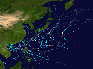
This timeline documents all of the events of the 2015 Pacific typhoon season. Most of the tropical cyclones formed between May and November. The scope of this article is limited to the Pacific Ocean, north of the equator between 100°E and the International Date Line. This area, called the Western Pacific basin, is the responsibility of the Japanese Meteorological Agency (JMA). They host and operate the Regional Specialized Meteorological Center (RSMC), located in Tokyo. The Japanese Meteorological Agency (JMA) is also responsible for assigning names to all tropical storms that are formed within the basin. However, any storm that enters or forms in the Philippine Area of Responsibility (PAR) will be named by the Philippine Atmospheric, Geophysical and Astronomical Services Administration (PAGASA) using a local name. Also of note - the Western Pacific basin is monitored by the United States' Joint Typhoon Warning Center (JTWC), which gives all Tropical depressions a number with a "W" suffix.

<span class="mw-page-title-main">Tropical Storm Mekkhala (2015)</span> Pacific typhoon in 2015

Severe Tropical Storm Mekkhala, known in the Philippines as Severe Tropical Storm Amang, was an early-season tropical cyclone that made landfall over the Philippines in January 2015. Mekkhala killed three people in the Bicol Region and caused light crop damage. Notably, the storm disturbed Pope Francis’ visit to the country after the victims of Typhoon Haiyan on November 8, 2013. Although the storm also caused an airplane crash in Tacloban, nobody was hurt in the incident.

<span class="mw-page-title-main">2022 Pacific typhoon season</span>

The 2022 Pacific typhoon season was the third consecutive season to have below average tropical cyclone activity, with twenty-five named storms forming. Of the tropical storms, ten became typhoons, and three would intensify into super typhoons. The season saw near-average activity by named storm count, although many of the storms were weak and short-lived, particularly towards the end of the season. This low activity was caused by an unusually strong La Niña that had persisted from 2020. The season's first named storm, Malakas, developed on April 6, while the last named storm, Pakhar, dissipated on December 12. The season's first typhoon, Malakas, reached typhoon status on April 12. The season ran throughout 2022, though most tropical cyclones typically develop between May and October. Tropical storms Megi and Nalgae were responsible for more than half of the casualties, while typhoons Hinnamnor and Nanmadol both caused $1 billion in damages.

<span class="mw-page-title-main">Typhoon Ewiniar (2024)</span> Pacific typhoon in 2024

Typhoon Ewiniar, known in the Philippines as Typhoon Aghon, is an active tropical cyclone currently weakening south of Japan. The first named storm and typhoon of the 2024 Pacific typhoon season. Ewiniar emerged from an area of atmospheric convection 441 km (274 mi) southeast of Palau. The Japan Meteorological Agency (JMA) labeled the system as a low-pressure area on May 21. It intensified the next day and became a tropical depression, giving it the name Aghon by the Philippine Atmospheric, Geophysical, and Astronomical Services Administration (PAGASA) after entering the Philippine Area of Responsibility on May 23, marking it as the fifth-latest start of a Pacific typhoon season since reliable records began; the depression intensified into a tropical storm, assigning it the name Ewiniar. The cyclone made nine landfalls in the Philippines. Afterward, it began to move over the warm tropical waters of Lamon Bay, where the Joint Typhoon Warning Center (JTWC) and the JMA upgraded Ewiniar into a minimal typhoon. Beginning to weaken for the final time on May 30, the storm passed directly over the island of Minamidaitōjima and began an extratropical transition.

References

  1. "Joint Typhoon Warning Center Mission Statement". Joint Typhoon Warning Center. 2011. Archived from the original on July 26, 2007. Retrieved July 25, 2012.
  2. Frequently Asked Questions (Report). Joint Typhoon Warning Center. August 13, 2012. Archived from the original on October 4, 2013. Retrieved September 22, 2012.
  3. 1 2 3 Lea, Adam; Wood, Nick (May 7, 2023). Extended Range Forecast for Northwest Pacific Typhoon Activity in 2024 (PDF) (Report). Tropical Storm Risk Consortium. Archived (PDF) from the original on May 6, 2023. Retrieved May 7, 2023.
  4. Wulfeck, Andrew (May 25, 2024). "Tracking the tropics: Northern Hemisphere finally sees its first tropical depression". FOX Weather. Retrieved May 25, 2024.
  5. Significant Tropical Weather Advisory for the Western and South Pacific Oceans, 06Z 21 May 2024 (Report). United States Joint Typhoon Warning Center. May 21, 2024. Archived from the original on May 21, 2024. Retrieved May 21, 2024.
  6. Tropical Cyclone Formation Alert (Invest 93W) (Report). United States Joint Typhoon Warning Center. May 22, 2024. Archived from the original on May 22, 2024. Retrieved May 22, 2024.
  7. Warning and Summary 221800 (Report). Tokyo, Japan: Japan Meteorological Agency. May 22, 2024. Archived from the original on May 22, 2024. Retrieved May 22, 2024.
  8. "Tropical Cyclone Advisory #1 for Low Pressure Area" (PDF). PAGASA . May 23, 2024. Archived from the original (PDF) on May 24, 2024. Retrieved May 23, 2024.
  9. "LPA develops into Tropical Depression east of Surigao del Sur". GMA Network. Retrieved May 24, 2024.
  10. Prognostic Reasoning for Tropical Depression 01W (One) Warning No. 1 (Report). United States Joint Typhoon Warning Center. May 24, 2024. Archived from the original on May 24, 2024. Retrieved May 24, 2024.
  11. "Tropical Cyclone Bulletin #7 for Tropical Depression 'Aghon'" (PDF). PAGASA . May 24, 2024. Archived from the original (PDF) on May 24, 2024. Retrieved May 24, 2024.
  12. 1 2 "Tropical Cyclone Bulletin #14 for Tropical Depression 'Aghon'" (PDF). PAGASA . May 26, 2024. Archived from the original (PDF) on May 25, 2024. Retrieved May 26, 2024.
  13. Tropical Depression 01W (One) Warning No. 3 (Report). United States Joint Typhoon Warning Center. May 25, 2024. Archived from the original on May 25, 2024. Retrieved May 25, 2024.
  14. Warning 2600000 (Report). Tokyo, Japan: Japan Meteorological Agency. May 26, 2024. Archived from the original on May 26, 2024. Retrieved May 26, 2024.
  15. Prognostic Reasoning for Tropical Storm 01W (Ewiniar) Warning No. 7 (Report). United States Joint Typhoon Warning Center. May 26, 2024. Archived from the original on May 27, 2024. Retrieved May 26, 2024.
  16. Prognostic Reasoning for Typhoon 01W (Ewiniar) Warning No. 8 (Report). United States Joint Typhoon Warning Center. May 26, 2024. Archived from the original on May 26, 2024. Retrieved May 26, 2024.
  17. "Tropical Cyclone Bulletin #21 for Severe Tropical Storm 'Aghon' (Aghon)" (PDF). PAGASA . May 26, 2024. Archived from the original (PDF) on May 26, 2024. Retrieved May 26, 2024.
  18. "Tropical Cyclone Information - T2401 ( EWINIAR )". Japan Meteorological Agency. May 27, 2024. Archived from the original on May 27, 2024.
  19. Prognostic Reasoning for Typhoon 01W (Ewiniar) Warning No. 16 (Report). United States Joint Typhoon Warning Center. May 28, 2024. Archived from the original on May 28, 2024. Retrieved May 28, 2024.
  20. "Tropical Cyclone Bulletin #35F for Typhoon 'Aghon' (Ewiniar)" (PDF). PAGASA . May 29, 2024. Archived from the original (PDF) on May 29, 2024. Retrieved May 29, 2024.
  21. "Tropical Cyclone Bulletin #35F for Typhoon 'Aghon' (Ewiniar)" (PDF). PAGASA . May 29, 2024. Archived from the original (PDF) on May 29, 2024. Retrieved May 29, 2024.
  22. Prognostic Reasoning for Tropical Storm 01W (Ewiniar) Warning No. 25 (Report). United States Joint Typhoon Warning Center. May 31, 2024. Archived from the original on May 31, 2024. Retrieved May 31, 2024.
  23. "WTPQ50 RJTD 301800". Japan Meteorological Agency. Archived from the original on May 30, 2024. Retrieved May 30, 2024.
  24. "7 hurt, over 19,000 affected by Aghon —NDRRMC". GMA News. May 27, 2024. Retrieved May 27, 2024.
  25. Situational Report No. 4 for TC AGHON (2024) (PDF) (Report). National Disaster Risk Reduction and Management Council. May 26, 2024. Retrieved May 28, 2024.{{cite report}}: CS1 maint: url-status (link)
  26. "3 dead in storm-hit Quezon province". The Manila Times. May 27, 2024. Retrieved May 27, 2024.
  27. "Century-old acacia tree falls on 2 vehicles in Taytay, Rizal amid Aghon". GMA News Online. May 26, 2024. Retrieved May 26, 2024.
  28. "19 bahay nasira sa hagupit ni Aghon sa Tanza, Cavite". GMA News (in Filipino). May 27, 2024. Retrieved May 27, 2024.
  29. "Bagyong Aghon, nananalasa sa Quezon Province". GMA News Online (in Filipino). May 26, 2024. Retrieved May 26, 2024.
  30. "Aghon causes flooding, impedes traffic in Calabarzon". GMA News Online. May 26, 2024. Retrieved May 26, 2024.
  31. "Kanto region faces heavy rain as Typhoon No. 1 approaches". The Asahi Shimbun. Retrieved May 30, 2024.
  32. Manila, RadyoMaN (May 30, 2024). "DPWH: Halaga ng pinsalang iniwan ng Bagyong Aghon sa imprastraktura, pumalo sa mahigit P600-M - RMN Networks". RMN Networks. Retrieved May 30, 2024.
  33. "Halaga ng pinsala sa sektor ng agrikultura dahil sa Bagyong Aghon, umabot na sa P57.5 milyon – DA". May 29, 2024. Archived from the original on May 29, 2024. Retrieved May 29, 2024.
  34. Significant Tropical Weather Advisory for the Western and South Pacific Oceans, 0230Z 30 May 2024 Reissued (Report). United States Joint Typhoon Warning Center. May 30, 2024. Archived from the original on May 30, 2024. Retrieved May 30, 2024.
  35. "Tropical Cyclone Information". Japan Meteorological Agency. May 30, 2024. Archived from the original on May 30, 2024.
  36. Tropical Cyclone Formation Alert (Invest 94W) (Report). United States Joint Typhoon Warning Center. May 30, 2024. Archived from the original on May 30, 2024. Retrieved May 30, 2024.
  37. "Hong Kong No 1 typhoon signal to remain in force until at least Friday morning". South China Morning Post. May 30, 2024. Retrieved May 30, 2024.
  38. 1 2 Padgett, Gary. "Monthly Tropical Cyclone Summary December 1999". Australian Severe Weather. Archived from the original on February 11, 2012. Retrieved October 1, 2013.
  39. 1 2 3 The Typhoon Committee (February 21, 2013). "Typhoon Committee Operational Manual 2013" (PDF). World Meteorological Organization. pp. 37–38. Archived (PDF) from the original on August 1, 2013. Retrieved October 1, 2013.
  40. "Review of the 2015 Pacific typhoon season" (PDF). www.typhooncommittee.org. January 25, 2016. Archived (PDF) from the original on March 24, 2016. Retrieved April 8, 2022.
  41. Zhou, Xiao; Lei, Xiaotu (2012). "Summary of retired typhoons within the Western North Pacific Ocean". Tropical Cyclone Research and Review. 1 (1). The Economic and Social Commission for Asia and the Pacific/World Meteorological Organization's Typhoon Committee: 23–32. doi:10.6057/2012TCRR01.03. ISSN   2589-3025. Archived from the original on August 12, 2017. Retrieved December 21, 2014.
  42. 1 2 3 "Philippine Tropical Cyclone Names". Philippine Atmospheric, Geophysical and Astronomical Services Administration. Archived from the original on December 28, 2016. Retrieved April 18, 2015.
  43. "Halaga ng pinsala sa sektor ng agrikultura ng Bagyong Aghon, umabot na sa mahigit P11 milyon". RMN Networks. May 28, 2024. Retrieved May 28, 2024.
  44. "Typhoon leaves at least seven people dead and thousands displaced in the Philippines". Washington Post. May 28, 2024. ISSN   0190-8286 . Retrieved May 28, 2024.
Tropical Depression
Movement NW slowly