
The 37th meridian west from Washington is an archaic meridian based on the Washington meridian. It is currently located at approximately 114 degrees, 3 minutes west of the Greenwich meridian. [1] The meridian is used as a boundary for two states.
The 37th meridian west from Washington is an archaic meridian based on the Washington meridian. It is currently located at approximately 114 degrees, 3 minutes west of the Greenwich meridian. [1] The meridian is used as a boundary for two states.
The first and only usage of the meridian as a boundary occurred in 1866. In that year, the state of Nevada's eastern boundary was pushed one degree further east to the current boundary. [2] This also had the effect of pushing the Utah Territory's western boundary further east. Utah would become a state in 1896. [3]

The Four Corners Monument marks the quadripoint in the Southwestern United States where the states of Arizona, Colorado, New Mexico, and Utah meet. It is the only point in the United States shared by four states, leading to the area being named the Four Corners region. The monument also marks the boundary between two semi-autonomous Native American governments, the Navajo Nation, which maintains the monument as a tourist attraction, and the Ute Mountain Ute Tribe Reservation.

The Territory of New Mexico was an organized incorporated territory of the United States that existed from September 9, 1850, until January 6, 1912, when the remaining extent of the territory was admitted to the Union as the State of New Mexico. This jurisdiction was an organized, incorporated territory of the United States for nearly 62 years, the longest period of any territory in the US.

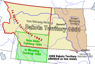
The Territory of Nevada (N.T.) was an organized incorporated territory of the United States that existed from March 2, 1861, until October 31, 1864, when it was admitted to the Union as the State of Nevada.

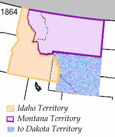
The Territory of Idaho was an organized incorporated territory of the United States that existed from March 3, 1863, until July 3, 1890, when the final extent of the territory was admitted to the Union as Idaho.
A survey township, sometimes called a Congressional township or just township, as used by the United States Public Land Survey System, is a nominally-square area of land that is nominally six U.S. survey miles on a side. Each 36-square-mile township is divided into 36 sections of one square mile each. The sections can be further subdivided for sale.

The Territory of Jefferson was an extralegal and unrecognized United States territory that existed from October 24, 1859 until the creation of the Colorado Territory on February 28, 1861. The Jefferson Territory, named for Founding Father and United States president Thomas Jefferson, included land officially part of the Kansas Territory, the Nebraska Territory, the New Mexico Territory, the Utah Territory, and the Washington Territory, but the area was remote from the governments of those five territories.

Time in the United States, by law, is divided into nine standard time zones covering the states, territories and other US possessions, with most of the United States observing daylight saving time (DST) for approximately the spring, summer, and fall months. The time zone boundaries and DST observance are regulated by the Department of Transportation. Official and highly precise timekeeping services (clocks) are provided by two federal agencies: the National Institute of Standards and Technology (NIST) ; and the United States Naval Observatory (USNO). The clocks run by these services are kept synchronized with each other as well as with those of other international timekeeping organizations.
The Washington meridians are four meridians that were used as prime meridians in the United States and pass through Washington, D.C. The four which have been specified are:
Roop County, until 1862 known as Lake County, was a county of Nevada Territory in the United States from 1861 until 1864. It was created in 1861 as one of the original nine counties of Nevada. In 1864 it was succeeded by Lassen County, California and Washoe County, Nevada.

The meridian 109° west of Greenwich is a line of longitude that extends from the North Pole across the Arctic Ocean, North America, the Pacific Ocean, the Southern Ocean, and Antarctica to the South Pole.
The Nataqua Territory was a short-lived, unofficial territory of the United States. It consisted of a portion of what is now northeastern California and northwestern Nevada. Nataqua Territory was the first incarnation of the proposed "State of Jefferson". In 1849, the border between California and the Utah Territory was defined by geographical coordinates that were not surveyed. On April 26, 1856, local residents took advantage of this ambiguity and justified their resistance to tax collectors from Plumas County, California, by proclaiming themselves part of a new "Territory of Nataqua." The twenty men of the Susanville convention who announced the Nataqua Territory had defined a rectangle-shaped territory by latitude and longitude, which inadvertently did not include their own Honey Lake Valley but did encompass most of what soon became western Nevada, along with 600 unsuspecting inhabitants. The Territory of Nataqua was a frontier land club or claim association, designed to protect the property rights of individual settlers until regular government reached the area. The movement was led by Peter Lassen and Isaac Roop. Association with the Utah Territory was unpalatable to the residents due to anti-Mormonism.

The geography of the U.S. State of Colorado is diverse, encompassing both rugged mountainous terrain, vast plains, desert lands, desert canyons, and mesas. Colorado is a landlocked U.S. state. In 1861, the United States Congress defined the boundaries of the new Territory of Colorado exclusively by lines of latitude and longitude, stretching from 37°N to 41°N latitude, and from 102°02'48"W to 109°02'48"W longitude. Starting in 1868, official surveys demarcated the boundaries, deviating from the parallels and meridians in several places. Later surveys attempted to correct some of these mistakes but in 1925 the U.S. Supreme Court affirmed that the earlier demarcation was the official boundary. The borders of Colorado are now officially defined by 697 boundary markers connected by straight boundary lines. Colorado, Wyoming, and Utah are the only states that have their borders defined solely by straight boundary lines with no natural features. The southwest corner of Colorado is the Four Corners Monument at 36°59'56"N, 109°2'43"W. This is the only place in the United States where four states meet: Colorado, New Mexico, Arizona, and Utah.
The parallel 36°30′ north is a circle of latitude that is 36 and one-half degrees north of the equator of the Earth. This parallel of latitude is particularly significant in the history of the United States as the line of the Missouri Compromise, which was used to divide the prospective slave and free states west of the Mississippi River, with the exception of Missouri, which is mostly north of this parallel.

The 25th meridian of longitude west from Washington is a line of longitude approximately 102.05 degrees west of the Prime Meridian of Greenwich. In the United States of America, the meridian 25 degrees west of the Washington Meridian defines the eastern boundary of the State of Colorado, the western boundary of the State of Kansas, and the western boundary of the State of Nebraska south of the 41st parallel north.
The 32nd meridian of longitude west from Washington is a line of longitude approximately 109°02′48″ west of the Prime Meridian of Greenwich. In the United States of America, the meridian 32 degrees west of the Washington Meridian defines the western boundaries of the State of Colorado and the State of New Mexico and the eastern boundaries of the State of Utah and the State of Arizona.

The 1872 California-Nevada State Boundary Marker marks the initial point for the 1872 survey delineation of the state line between California and Nevada. It is listed in the National Register of Historic Places.
State Street is a wide 17.3-mile-long (27.8 km) street in Salt Lake County, Utah leading almost straight south from the steps of the Utah State Capitol Building, through Salt Lake City, South Salt Lake, Millcreek, Murray, eastern Midvale, Sandy, and northwestern Draper. Because it follows the most direct route from downtown Salt Lake City to the Point of the Mountain pass to Utah County, it was the undisputed main road south from Salt Lake City until Interstate 15 (I-15) was built to the west. It retains the U.S. Highway 89 (US-89) designation for all but the northernmost seven blocks despite I-15's proximity. Due to its history as a route for long-distance travel, travel within the Wasatch Front region, and travel between the cities along the east side of the Jordan River, it has attracted a wide variety of retail and service businesses along its entire length, creating a nearly continuous commercial axis for the Salt Lake Valley.
The 27th meridian west from Washington is an archaic meridian based on the Washington Meridian. The meridian is approximately 104 degrees west of the Prime Meridian. It is used as the boundary of five states.
The 34th meridian west from Washington is an archaic meridian based on the Washington Meridian and hence 111°2′48.0″ West of Greenwich. The meridian is most notably used as a boundary for four states.
| | This article about a specific United States location is a stub. You can help Wikipedia by expanding it. |