The governor of Gibraltar is the representative of the British monarch in the British overseas territory of Gibraltar. The governor is appointed by the monarch on the advice of the British government. The role of the governor is to act as the de facto head of state. They are responsible for formally appointing the chief minister of Gibraltar, along with other members of the government of Gibraltar after a general election. The governor serves as commander-in-chief of Gibraltar's military forces and has sole responsibility for defence and security. Although recent appointments have all been former military personnel, most being former Royal Navy or Royal Marines flag officers, Sir James Dutton resigned from the role in 2015, complaining that it was "more representational and ceremonial than I had expected".
Monte Hacho is a low mountain that overlooks the Spanish city of Ceuta, on the north coast of Africa. Monte Hacho is positioned on the Mediterranean coast at the Strait of Gibraltar opposite Gibraltar, and along with the Rock of Gibraltar is claimed by some to be one of the Pillars of Hercules. According to the legend, Hercules pushed apart the two mountains and created a link between the Mediterranean and the Atlantic.

The flag of the Commonwealth of Nations is the official flag used by and representing the Commonwealth of Nations. Its current design dates to 2013, a modification of a design adopted in 1976.
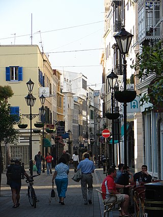
Main Street is the main arterial street in the British overseas territory of Gibraltar.

The chief justice of the Supreme Court of Gibraltar is one of the four judges who make up the supreme court of Gibraltar. Previously the chief justice was appointed by the Governor of Gibraltar on the advice of the British Foreign and Commonwealth Office. Under the 2006 Constitution the Governor, on the advice of the Judicial Service Commission, makes the appointment on behalf of the Monarch.

RFA Bedenham was a naval armament carrier of the British Royal Fleet Auxiliary that exploded while docked in Gibraltar on 27 April 1951, killing 13 people and causing a great deal of damage to the town.

Gibraltar is a British Overseas Territory and city located at the southern tip of the Iberian Peninsula, on the Bay of Gibraltar, near the exit of the Mediterranean Sea into the Atlantic Ocean. It has an area of 6.7 km2 (2.6 sq mi) and is bordered to the north by Spain. The landscape is dominated by the Rock of Gibraltar, at the foot of which is a densely populated town area, home to some 32,688 people, primarily Gibraltarians.

The Convent has been the official residence of the governor of Gibraltar since 1728. It was originally a convent of Franciscan friars, hence its name, and was built in 1531, and heavily rebuilt during the 18th and 19th centuries.
Charles Caruana CBE was a Gibraltarian Roman Catholic bishop of Maltese descent. He was appointed sixth Roman Catholic Bishop of Gibraltar on 14 February 1998 and ordained on 24 May 1998. His retirement request was accepted on 18 March 2010. He died at St Bernard's Hospital, Gibraltar on 1 October 2010 following a bout of ill health.

Winston Churchill Avenue is an arterial road in the British overseas territory of Gibraltar, and is the only road in and out of the territory, connecting it with Spain. Once the customs are crossed, the avenue becomes the dual carriageway CA-34.

This is a survey of the postage stamps and postal history of Gibraltar.

Our Lady of Europe is a title given to the Blessed Virgin Mary patroness of Gibraltar and protectress of Europe. The entire European continent was consecrated under the protection of Our Lady of Europe in the early 14th century from the Shrine in Gibraltar where devotion continues to this day, over 700 years on.

Bristol Hotel is Gibraltar's oldest hotel. It is located on Cathedral Square in Gibraltar, next to the Church of England Cathedral of The Holy Trinity. Established in 1894 the 19th century, it occupies a white colonial building with swimming pool and garden, located to the south of Cathedral of St. Mary the Crowned, next to the Gibraltar Museum. The hotel has 60 rooms and includes a subtropical garden.

The North Mole is a breakwater located in the northern section of Gibraltar Harbour, in the British Overseas Territory of Gibraltar, at the southern end of the Iberian Peninsula. The North Mole, with the rest of harbour, is just north of the east entrance to the Strait of Gibraltar. The breakwater was formerly known as the Commercial Mole, and is the site of the commercial port in the harbour. It was the consequence of a late nineteenth century plan by the British Admiralty to create a modern dockyard and large defensive harbour in Gibraltar.

The American War Memorial is a World War I memorial in the British Overseas Territory of Gibraltar. It was built for the American Battle Monuments Commission in 1933, and incorporated into the main city wall, the Line Wall Curtain. It commemorated the successful alliance of the United States and the United Kingdom in their naval exploits in the vicinity of Gibraltar during the Great War. The monument was inaugurated in 1937. Sixty-one years later, in November 1998, the monument was the site of another unveiling ceremony, that of a bronze plaque which commemorated the World War II Allied invasion of North Africa, Operation Torch. That unveiling ceremony was one of a number of events that weekend whose guests included dignitaries from the United Kingdom and the United States.
St. Jago's Cemetery was a cemetery in the British Overseas Territory of Gibraltar. Also known as Deadman's Cemetery, it was positioned just north of the Charles V Wall. The burial ground was initially used for the poor Spaniards of La Turba; following the 1704 capture of Gibraltar, it was utilised as a Protestant cemetery. In 1929, the burial ground was incorporated into the St. Jago's Barracks recreational facilities. Three years later, some of the remaining headstones were transferred to Trafalgar Cemetery. Little evidence of the former cemetery remains. It is notable as the earliest cemetery in Gibraltar as well as the only one within the city limits.

King's Chapel is a small chapel in the British Overseas Territory of Gibraltar. It is located at the southern end of Main Street and adjoins the Governor of Gibraltar's residence, The Convent. What nowadays is King's Chapel was the first purpose-built church to be constructed in Gibraltar. Originally part of a Franciscan friary, the chapel was built in the 1530s but was given to the Church of England by the British after the capture of Gibraltar in 1704. It was badly damaged in the late 18th century during the Great Siege of Gibraltar and in the explosion of an ammunition ship in Gibraltar harbour in 1951, but was restored on both occasions. From 1844 to 1990 it served as the principal church of the British Army in Gibraltar; since then it has been used by all three services of the British Armed Forces.

Town Range is a major road in the British Overseas Territory of Gibraltar. It is located in the old town area and runs parallel to Main Street and part of Prince Edward's Road. It is also known in Spanish as Calle Cuartel, in reference to the barracks constructed on the street in 1740. It is one of the three main parallel streets in the old town and is likely to date back to the Moorish period. Until the mid-19th century it was notorious for its filthiness due to wholly inadequate sanitation and lack of any running water supply. It was the point of outbreak of Gibraltar's devastating 1804 epidemic of yellow fever, which killed a third of the territory's population. The street is now a residential and commercial area notable for several important public buildings in addition to the old Georgian barracks, which have been converted for civilian use.

Windmill Hill or Windmill Hill Flats is one of a pair of plateaux, known collectively as the Southern Plateaux, at the southern end of the British Overseas Territory of Gibraltar. It is located just to the south of the Rock of Gibraltar, which descends steeply to the plateau. Windmill Hill slopes down gently to the south with a height varying from 120 metres (390 ft) at the north end to 90 metres (300 ft) at the south end. It covers an area of about 19 hectares, though about 6 hectares at the north end is built over. The plateau is ringed to the south and east with a line of cliffs which descend to the second of the Southern Plateaux, Europa Flats, which is itself ringed by sea cliffs. Both plateaux are the product of marine erosion during the Quaternary period and subsequent tectonic uplift. Windmill Hill was originally on the shoreline and its cliffs were cut by the action of waves, before the ground was uplifted and the shoreline moved further out to the edge of what is now Europa Flats.

Alison Flora MacMillan,, is a British diplomat, who served as Deputy Governor of Gibraltar from 2013 to 2016. For two periods during 2013 and 2015, MacMillan served as governor in an acting capacity.