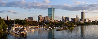
Back Bay is an officially recognized neighborhood of Boston, Massachusetts, built on reclaimed land in the Charles River basin. Construction began in 1859, as the demand for luxury housing exceeded the availability in the city at the time, and the area was fully built by around 1900. It is most famous for its rows of Victorian brownstone homes—considered one of the best preserved examples of 19th-century urban design in the United States—as well as numerous architecturally significant individual buildings, and cultural institutions such as the Boston Public Library, and Boston Architectural College. Initially conceived as a residential-only area, commercial buildings were permitted from around 1890, and Back Bay now features many office buildings, including the John Hancock Tower, Boston's tallest skyscraper. It is also considered a fashionable shopping destination and home to several major hotels.
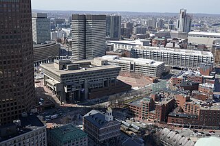
Government Center is an area in downtown Boston, centered on City Hall Plaza. Formerly the site of Scollay Square, it is now the location of Boston City Hall, courthouses, state and federal office buildings, and a major MBTA subway station, also called Government Center. Its development was controversial, as the project displaced thousands of residents and razed several hundred homes and businesses.

Faneuil Hall is a marketplace and meeting hall located near the waterfront and today's Government Center, in Boston, Massachusetts. Opened in 1742, it was the site of several speeches by Samuel Adams, James Otis, and others encouraging independence from Great Britain. It is now part of Boston National Historical Park and a well-known stop on the Freedom Trail. It is sometimes referred to as "the Cradle of Liberty", though the building and location have ties to slavery.

60 State Street is a modern skyscraper on historic State Street in the Government Center neighborhood of Boston, Massachusetts. Completed in 1977, it is Boston's 19th tallest building, standing 509 feet tall, and housing 38 floors.

Quincy Market is a historic building near Faneuil Hall in downtown Boston, Massachusetts. It was constructed between 1824 and 1826 and named in honor of mayor Josiah Quincy, who organized its construction without any tax or debt. The market is a designated National Historic Landmark and a designated Boston Landmark in 1996, significant as one of the largest market complexes built in the United States in the first half of the 19th century. According to the National Park Service, some of Boston's early slave auctions took place near what is now Quincy Market.

The Rose Fitzgerald Kennedy Greenway is a linear park located in several Downtown Boston neighborhoods. It consists of landscaped gardens, promenades, plazas, fountains, art, and specialty lighting systems that stretch over one mile through Chinatown, the Financial District, the Waterfront, and North End neighborhoods. Officially opened in October 2008, the 17-acre Greenway sits on land created from demolition of the John F. Fitzgerald Expressway as part of the Big Dig project.
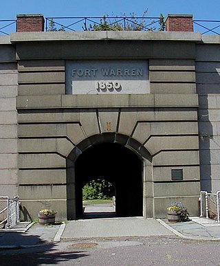
Fort Warren is a historic fort on the 28-acre (110,000 m2) Georges Island at the entrance to Boston Harbor. The fort is named for Revolutionary War hero Dr. Joseph Warren, who sent Paul Revere on his famous ride, and was later killed at the Battle of Bunker Hill. The name was transferred in 1833 from the first Fort Warren – built in 1808 – which was renamed Fort Winthrop.

Boston City Hall is the seat of city government of Boston, Massachusetts. It includes the offices of the mayor of Boston and the Boston City Council. The current hall was built in 1968 to assume the functions of the Old City Hall.

Rainsford Island, formerly known Hospital Island, Pest House Island, and Quarantine Island, is a 11-acre (45,000 m2) island in the Boston Harbor, situated between Long Island and Peddocks Island. The island is composed of two drumlins, reaching an elevation of 49 feet (15 m) above sea level. The shoreline is predominantly rocky with a sandy cove in the south side, and a variety of wildflowers abound. Access is by private boat only. Since 1996 it has been part of the Boston Harbor Islands National Recreation Area.

Bumpkin Island, also known as Round Island, Bomkin Island, Bumkin Island, or Ward's Island, is an island in the Hingham Bay area of the Boston Harbor. In 1902, Albert Burrage, a Boston philanthropist, had a summer hospital opened on the island for children with physical disabilities. During World War I the island was used by the U.S. Navy. Starting around 1940, the island was used as a facility for polio patients. However, the hospital closed during World War II and burned down in 1945. Since 1996, it is part of the Boston Harbor Islands National Recreation Area. The island has an area of 30 acres (120,000 m2), plus an intertidal zone of a further 31 acres (130,000 m2). It is composed of a central drumlin with an elevation of 70 feet (21 m) above sea level, surrounded by a rock-strewn shoreline. A sand spit, exposed at low tide, connects the eastern end of the island to Sunset Point in Hull.

Long Wharf is a historic American pier in Boston, Massachusetts, built between 1710 and 1721. It once extended from State Street nearly a half-mile into Boston Harbor; today, the much-shortened wharf functions as a dock for passenger ferries and sightseeing boats.

Boston Harborwalk is a public walkway that follows the edge of piers, wharves, beaches, and shoreline around Boston Harbor. When fully completed it will extend a distance of 47 miles (76 km) from East Boston to the Neponset River.
Ross Miller is an American visual artist. His work integrates art into the public landscape. Through site-based projects, his work reinforces community identity in outdoor spaces and creates places for private reflection within public environments.

Raspberry Island is located in the Mississippi River in Saint Paul, Minnesota, United States. Buildings for the Minnesota Boat Club have sat upon the island since 1885; the Minnesota Boat Club Boathouse structure was built in 1910. Between 1949 and 1968, the island was used by the United States Navy. The City of Saint Paul manages the island as part of the Harriet Island Regional Park. Paths, a plaza, and a bandshell were installed on Raspberry Island during renovations by the city in the early 2000s.
Pablo Eduardo is a Bolivian sculptor. He creates a wide variety of sculptures for many purposes. Although he sculpts in many different countries, most of his major works have been made in the United States, England, and Bolivia.

Dock Square in downtown Boston, Massachusetts, is a public square adjacent to Faneuil Hall, bounded by Congress Street, North Street, and the steps of the 60 State Street office tower. Its name derives from its original (17th-century) location at the waterfront. From the 1630s through the early 19th century, it served boats in the Boston Harbor as "the common landing place, at Bendell's Cove," later called Town Dock. "Around the dock was transacted the chief mercantile business of the town." After the waterfront was filled in during the early 19th century, Dock Square continued as a center of commerce for some years. The addition in the 1960s of Government Center changed the scale and character of the square from a hub of city life, to a place one merely passes through. As of the 1950s the square has become largely a tourist spot, with the Freedom Trail running through it. John Winthrop, coming from Salem where he landed as a Puritan from England, ended up "setting up a dock at the head of the cove, and here began the town of Boston, which soon was recognized as the political and economic center of the [Massachusetts Bay] colony.
Anne Whitney created two public statues of Samuel Adams. One, made in 1876, resides in the National Statuary Hall Collection in the US Capitol, Washington, D.C. The other, made in 1880, is located in front of Faneuil Hall Plaza in Boston.

Harbor Fog, stilled buoys dream of a lost harbor, is a responsive sensor-activated interactive contemporary public sculptural environment located in Boston along the main pedestrian walkway of Wharf District Park Parcel 17, on the Rose Fitzgerald Kennedy Greenway. The first permanent public artwork along the Greenway, the concept was selected through a competition for commission by the Mass Highway Department, and integrated into site construction in collaboration with engineers during building of the Central Artery/Tunnel Project.

Bearskin Neck is a peninsula located on the coastline of Cape Ann in Rockport, Massachusetts. The location played a vital role during the War of 1812. Today it is a tourist destination known for its shops and art galleries. The stores and restaurants are known for jewelry, local artwork, and fresh seafood.

