A reconnaissance satellite or intelligence satellite is an Earth observation satellite or communications satellite deployed for military or intelligence applications.

The Corona program was a series of American strategic reconnaissance satellites produced and operated by the Central Intelligence Agency (CIA) Directorate of Science & Technology with substantial assistance from the U.S. Air Force. The CORONA satellites were used for photographic surveillance of the Soviet Union (USSR), China, and other areas beginning in June 1959 and ending in May 1972.

The National Reconnaissance Office (NRO) is a member of the United States Intelligence Community and an agency of the United States Department of Defense which designs, builds, launches, and operates the reconnaissance satellites of the U.S. federal government. It provides satellite intelligence to several government agencies, particularly signals intelligence (SIGINT) to the NSA, imagery intelligence (IMINT) to the NGA, and measurement and signature intelligence (MASINT) to the DIA. The NRO announced in 2023 that it plans within the following decade to quadruple the number of satellites it operates and increase the number of signals and images it delivers by a factor of ten.

BYEMAN codenamed GAMBIT, the KH-7 was a reconnaissance satellite used by the United States from July 1963 to June 1967. Like the older CORONA system, it acquired imagery intelligence by taking photographs and returning the undeveloped film to earth. It achieved a typical ground-resolution of 2 ft (0.61 m) to 3 ft (0.91 m). Though most of the imagery from the KH-7 satellites was declassified in 2002, details of the satellite program remained classified until 2011.

The KH-8 was a long-lived series of reconnaissance satellites of the "Key Hole" (KH) series used by the United States from July 1966 to April 1984, and also known as Low Altitude Surveillance Platform. The satellite ejected "film-bucket" canisters of photographic film that were retrieved as they descended through the atmosphere by parachute. Ground resolution of the mature satellite system was better than 4 inches (0.10 m). There were 54 launch attempts of the 3,000 kilogram satellites, all from Vandenberg Air Force Base, on variants of the Titan III rocket. Three launches failed to achieve orbit. The first one was satellite #5 on April 26, 1967, which fell into the Pacific Ocean after the Titan second stage developed low thrust. The second was satellite #35 on May 20, 1972, which suffered an Agena pneumatic regulator failure and reentered the atmosphere. A few months later, pieces of the satellite turned up in England and the US managed to arrange for their hasty return. The third failure was satellite #39 on June 26, 1973, which suffered a stuck Agena fuel valve. The Bell 8096 engine failed to start and the satellite burned up in the atmosphere. The KH-8 was manufactured by Lockheed. The camera system/satellite was manufactured by Eastman Kodak's A&O Division in Rochester, New York.
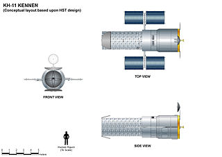
The KH-11 KENNEN is a type of reconnaissance satellite first launched by the American National Reconnaissance Office (NRO) in December 1976. Manufactured by Lockheed in Sunnyvale, California, the KH-11 was the first American spy satellite to use electro-optical digital imaging, and so offer real-time optical observations.

The Satellite Data System (SDS) is a system of United States military communications satellites. At least three generations have been used: SDS-1 from 1976 to 1987; SDS-2 from 1989 to 1996; SDS-3 from 1998 to the present. It is believed that these satellites were known by the code name Quasar. The first generation was named simply 'SDS', the second generation was named 'Quasar' and the third generation each had their own designations.

The U.S. Tracking and Data Relay Satellite System (TDRSS) is a network of American communications satellites and ground stations used by NASA for space communications. The system was designed to replace an existing network of ground stations that had supported all of NASA's crewed flight missions. The prime design goal was to increase the time spacecraft were in communication with the ground and improve the amount of data that could be transferred. Many Tracking and Data Relay Satellites were launched in the 1980s and 1990s with the Space Shuttle and made use of the Inertial Upper Stage, a two-stage solid rocket booster developed for the shuttle. Other TDRS were launched by Atlas IIa and Atlas V rockets.

ISTAR stands for intelligence, surveillance, target acquisition, and reconnaissance. In its macroscopic sense, ISTAR is a practice that links several battlefield functions together to assist a combat force in employing its sensors and managing the information they gather.

Lacrosse or Onyx was a series of terrestrial radar imaging reconnaissance satellites operated by the United States National Reconnaissance Office (NRO). While not officially confirmed by the NRO or the Government of the United States prior to 2008, there was widespread evidence pointing to its existence, including one NASA website. In July 2008, the NRO itself declassified the existence of its synthetic aperture radar (SAR) satellite constellation.
The Aerospace Corporation is an American nonprofit corporation that operates a federally funded research and development center (FFRDC) in El Segundo, California. The corporation provides technical guidance and advice on all aspects of space missions to military, civil, and commercial customers. As the FFRDC for national-security space, Aerospace works closely with organizations such as the United States Space Force (USSF) and the National Reconnaissance Office (NRO) to provide "objective technical analyses and assessments for space programs that serve the national interest". Although the USSF and NRO are the primary customers, Aerospace also performs work for civil agencies such as NASA and NOAA as well as international organizations and governments in the national interest.
Future Imagery Architecture (FIA) was a program awarded to Boeing to design a new generation of optical and radar imaging US reconnaissance satellites for the National Reconnaissance Office (NRO). In 2005 NRO director Donald Kerr recommended the project's termination, and the optical component of the program was finally cancelled in September 2005 by Director of National Intelligence John Negroponte. FIA has been called by The New York Times "perhaps the most spectacular and expensive failure in the 50-year history of American spy satellite projects." Despite the optical component's cancellation, the radar component, known as Topaz, has continued, with four satellites in orbit as of February 2016.

KH-9, commonly known as Big Bird or KeyHole-9, was a series of photographic reconnaissance satellites launched by the United States between 1971 and 1986. Of twenty launch attempts by the National Reconnaissance Office, all but one were successful. Photographic film aboard the KH-9 was sent back to Earth in recoverable film return capsules for processing and interpretation. The highest ground resolution achieved by the main cameras of the satellite was 2 ft (0.61 m), though another source says "images in the "better-than-one-foot" category" for the last "Gambit" missions.

Jeffrey King Harris is an American aerospace executive who served as 11th director of the National Reconnaissance Office from 1994 to 1996. Currently, he chair of the RIT Board of Trustees.

Brigadier General Cary C. Chun is a retired senior officer of the United States Air Force. He served as the Deputy Commander, Operations and Interagency Integration, Joint Functional Component Command for Space, United States Strategic Command (USSTRATCOM), and the Director for Mission Operations, National Reconnaissance Office. In this role, he led all Department of Defense space forces aligned with USSTRATCOM and provided tailored, responsive, local and global effects in support of national, USSTRATCOM and combatant commander objectives. As Director for Mission Operations, he led operations for all NRO overhead reconnaissance systems, ground stations, operational communications, and the operations center used to conduct intelligence activities essential for the national security of the United States and its allies.

Aerospace Data Facility-Colorado (ADF-C) or Space Delta 20 one of three satellite ground stations operated by the National Reconnaissance Office (NRO) and United States Space Force in the continental United States. Located within Buckley Space Force Base in Aurora, Colorado, the facility is responsible for the command and control of reconnaissance satellites involved in the collection of intelligence information and for the dissemination of that intelligence to other U.S. government agencies.

Aerospace Data Facility-Southwest (ADF-SW) is one of three satellite ground stations operated by the National Reconnaissance Office (NRO) in the continental United States. Located within White Sands Missile Range in southern New Mexico, the facility is responsible for the command and control of reconnaissance satellites involved in the collection of intelligence information and for the dissemination of that intelligence to other U.S. government agencies.

Christopher Stephen Povak is a United States Space Force major general who serves as the deputy director of the National Reconnaissance Office and commander of the Space Force Element to the National Reconnaissance Office. He previously served as the deputy director of the Space Warfighting Analysis Center.

Robert Joseph Schreiner is a United States Space Force colonel who serves as commander of Space Delta 20 and Aerospace Data Facility-Colorado. He also served as director of space forces of the Ninth Air Force. In 2024, he was nominated for promotion to brigadier general.