Related Research Articles

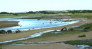
Aberffraw is a small village and community on the south west coast of the Isle of Anglesey, in Wales, by the west bank of the Afon Ffraw. Access by road is by way of the A4080 and the nearest rail station is Bodorgan.
Abergwyngregyn is a village and community of historical note in Gwynedd, a county and principal area in Wales. Under its historic name of Aber Garth Celyn it was the seat of Llywelyn ap Gruffudd. It lies in the historic county of Caernarfonshire.
The Anglesey Coastal Path is a 200-kilometre (124 mi) long-distance footpath around the island of Anglesey in North Wales. The route is part of the Wales Coast Path.

Llanbadrig is a village and community in the Welsh county of Anglesey. The parish includes the township of Clygyrog, Tregynrig and the port of Cemaes, and was formerly in the cwmwd of Talybolion. The area has extensive quarries of limestone and marble. At the 2001 census it had a population of 1,392, reducing slightly to 1,357 at the 2011 census.

Afon Cefni is one of the major rivers on the island of Anglesey, Wales. It is 16.9 kilometres (11 mi) long. The river starts at the Llyn Cefni in the centre of the island and then runs south through the county town of Llangefni. Just north of the A55 the river turns and flows south-west. It passes through the flatlands of the Malltraeth Marshes, where the river course was altered in 1824, creating a canal-like straight stretch. This part of the river and the surrounding marshes, part of which is a RSPB reserve, are frequented by a variety of wetland birds which in their turn are preyed on by falcons, hawks and harriers. A cycle trail follows the straightened course of the river as it flows through the marshes.

Bodorgan is a hamlet and a surrounding community area on the Isle of Anglesey, Wales, United Kingdom. According to the United Kingdom Census 2001, there are 1,503 residents in the electoral ward, 72.7% of them being able to speak Welsh. This increased to 1,704 at the 2011 Census but only 67.72% of this increased population were Welsh speakers.

The A4080 is a British A road which is located on the Island of Anglesey, Wales. It follows a very roundabout route from the A5 road at Llanfairpwllgwyngyll via Newborough and Rhosneigr back to the A55 and the A5 about 9 miles south of Holyhead. In all the road is about 17 miles long.

Anglesey, an island off the north-west coast of Wales, forms a principal area as Isle of Anglesey and a homonymous historic county, which includes Holy Island to the west and some islets and skerries. The island, at 260 square miles (673 km2), is the largest off the coast of Wales, the seventh largest off the British Isles, and the second most populous after the Isle of Man. The Isle of Anglesey County Council area measures 276 square miles (715 km2), with a 2011 census population of 69,751, including 13,659 on Holy Island, separated from the main island by the narrow Cymyran Strait. The Menai Strait between Anglesey and mainland Wales is spanned by the Menai Suspension Bridge designed by Thomas Telford in 1826 and the Britannia Bridge, built in 1850 and replaced in 1980. The largest town, Holyhead on Holy Island, handles over 2 million passengers a year to and from Ireland. The next largest is Llangefni, the county council seat. From 1974 to 1996 Anglesey was part of Gwynedd. Most inhabitants are habitual Welsh speakers. The name Ynys Môn is used for the UK Parliament and Senedd constituencies. The LL postcode area is LL58–LL78.

The River Llyfnant is a short river in Ceredigion, on the west coast of Wales. The river rises in the mountains south of Machynlleth, reaches the hill walk of Uwch Garreg and then plunges over a series of waterfalls known as Pistyll y Llyn, into a ravine, descending towards the River Dovey near Dovey Junction railway station.
The Afon Alaw is a river on Anglesey in Wales which rises near Llanerch-y-medd and flows northwards into the reservoir of Llyn Alaw. Below the dam it then flows southwestwards to the island's west coast near Llanfachraeth. Its lower reaches, west of the A5025 road, are tidal.

The Afon Marlais is a right-bank tributary of the Afon Cothi in Carmarthenshire, West Wales. It rises on the slopes of Mynydd Llanfihangel-rhos-y-corn and Mynydd Tre-beddau and flows south-eastwards through Brechfa Forest before reaching the village of Brechfa. After a further kilometre it joins the Cothi immediately downstream of Pont Ynys-Brechfa.

Many parts of Wales are protected areas, according to a number of designations. They include three national parks, and five Areas of Outstanding Natural Beauty.

Llaneilian is a village and community in the Welsh county of Anglesey. It is located in the north east of the island, 2.2 miles (3.5 km) east of Amlwch, 16.5 miles (26.6 km) north west of Menai Bridge and 12.5 miles (20.1 km) north of Llangefni. The community includes the villages and hamlets of Dulas, Llaneilian, Pengorffwysfa, Cerrig Man and Penysarn, Gadfa and Nebo, and at the 2001 census had a population of 1,192, decreasing slightly to 1,186 at the 2011 Census. The parish is crowned by its hill, Mynydd Eilian, a HuMP, popular with walkers and ramblers, and its beach, Traeth Eilian, which is popular with holidaymakers and for watersport activities. At the north easternmost point is Point Lynas,, while Ynys Dulas lies off the North East coast of the island, east of Dulas Bay.
Llanfachraeth is a village and community in the Welsh county of Anglesey. It is located near the west coast of the island, at the head of the Alaw estuary, 6.2 miles (10.0 km) east of Holyhead, 11.7 miles (18.8 km) south west of Amlwch and 11.3 miles (18.2 km) north west of Llangefni. The A5025 road runs through the village. A bus service operates along this road daily, except for Sundays, running between Cemaes, Llanfaethlu, Llanfachraeth and Holyhead. The Wales Coast Path is forced inland here to cross the Afon Alaw. The village has a pub and accommodation is provided by the Holland Hotel.
Llanfaelog is a village and community in western Anglesey, Wales. It is situated some 13 kilometres south-east of Holyhead and 22 kilometres west of the city of Bangor. At the 2001 census, it had a population of 1,679, increasing to 1,758 at the 2011 Census. The community includes Rhosneigr, Bryn Du, and Pencarnisiog.
The Afon Ysgethin is a short river in Gwynedd, Wales. Flowing entirely within Snowdonia National Park it rises beneath the peaks of Y Llethr and Diffwys within the Rhinogs mountain range and runs in a generally ESE direction towards Cardigan Bay. Headwater streams flow into Llyn Bodlyn reservoir and a small upper lake, Llyn Dulyn. The river emerging from the reservoir dam is crossed by an historic track at Pont Scethin. This old stone arch bridge was used historically by packhorses and drovers moving between Harlech and London. A further 3km downstream it enters a narrower wooded valley and is crossed by Pont Fadog. There are two further crossings at the village of Tal-y-bont; by the A496 road and by the Cambrian Coast railway. After another 1km it enters the sea.
The Afon Gwyrfai is a short river in Gwynedd, Wales. For half of its length it flows through Snowdonia National Park. Exiting Llyn y Gader it flows north through the small village of Rhyd-ddu to enter the southeastern end of Llyn Cwellyn. Downstream of the lake it flows northwest past Betws Garmon, leaving the national park and continues to the southern edge of Waunfawr. It then turns slightly west to flow on to Bontnewydd beyond which it turns slightly south to enter Foryd Bay. The tidal channel within the bay flows north into the western end of the Menai Strait. Principal tributary streams include the Afon Treweunydd which contributes water from the reservoir of Llyn Ffynnon-y-gwas and from the lakes of Llyn Glas, Llyn Coch and Llyn Nadroedd in Cwm Clogwyn immediately west of the summit of Snowdon. The tidal channel of the Gwyrfai within Foryd Bay also accepts the flow of the left bank tributaries, the Afon Foryd, Afon Rhyd and Afon Carrog. The river is shadowed by the line of the Welsh Highland Railway for much of its length, and by which it is crossed four times.
The Afon Soch is a short river on the Llŷn peninsula, Gwynedd, Wales. It arises to the north of the village of Sarn Meyllteyrn, through which it then flows, turning southeast towards Botwnnog. Beyond Botwnnog it is joined by its main left-bank tributary, the Afon Horon, which rises to the east of Carn Fadryn. Their combined flow approaches the coast at Porth Neigwl but instead the river turns sharply northwards at Llanengan and curves around east to Abersoch where it enters the sea. A short section of the Soch valley is followed by the Wales Coast Path where it takes a route inland of Porth Neigwl. Both the Soch and the Horon are misfit streams within valleys that were formed by glacial meltwater. The river name is reckoned to be of Irish origin, the old Irish word 'socc' meaning a sow. There are a number of other Irish names in Llŷn.
References
- ↑ 262 Anglesey West[Gorllewin Ynys Môn] (Map) (A1 ed.). 1:25,000. Explorer. Ordnance Survey. 2005. ISBN 0319236501.
- ↑ 262 Anglesey East[Dwyrain Ynys Môn] (Map) (A1 ed.). 1:25,000. Explorer. Ordnance Survey. 2005. ISBN 031923651X.
- ↑ "Pont Aberffraw". coflein. RCAHMW. Retrieved 15 January 2021.
Coordinates: 53°10′56″N4°28′00″W / 53.18226°N 4.46664°W
| | This Anglesey location article is a stub. You can help Wikipedia by expanding it. |