Alpine, Utah

Last updated

Alpine, Utah
Alpine UT aerial.JPG
Overlooking Alpine
Utah County Utah incorporated and unincorporated areas Alpine highlighted.svg
Location in Utah County and the state of Utah
Usa edcp location map.svg
Red pog.svg
Alpine, Utah
Location in the United States
Coordinates: 40°27′23″N111°45′25″W / 40.45639°N 111.75694°W / 40.45639; -111.75694 [1]
Country United States
State Utah
County Utah
Settled1850
Incorporated January 19, 1855
Area
[2]
  Total
7.95 sq mi (20.60 km2)
  Land7.95 sq mi (20.60 km2)
  Water0 sq mi (0.00 km2)
Elevation
[1]
5,049 ft (1,539 m)
Population
 (2020)
  Total
10,251
  Density1,319.7/sq mi (509.55/km2)
Time zone UTC-7 (MST)
  Summer (DST) UTC-6 (MDT)
ZIP code
84004
Area codes 385, 801
FIPS code 49-00540 [3]
GNIS feature ID2409686 [1]
Website City of Alpine

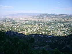
Alpine is a city on the northeastern edge of Utah County, Utah, United States. The population was 10,251 at the time of the 2020 census. Alpine has been one of the many quickly-growing cities of Utah since the 1970s, especially in the 1990s. This city is thirty-two miles southeast of Salt Lake City. It is located on the slopes of the Wasatch Range north of Highland and American Fork. The west side of the city runs above the Wasatch Fault. [4]

Contents

History

Digital reconstruction of the city flag, c1860s Alpine, Utah flag (c. 1860).png
Digital reconstruction of the city flag, c1860s

The area, which would one day become Alpine, was settled by William Wordsworth and several other homesteading families in the fall of 1850. [6] The town was originally called Mountainville, and under the latter name settlement was first made in 1851. [7] The city was renamed because the views from the elevated town site were compared to the Swiss Alps. [8] In the 1860s Mrs. Joseph Walton made a flag to represent the city. The flag was carried across the county, it flew for 40 years. [5]

Geography

Alpine is located on State Route 74, just north of the city of Highland.

According to the United States Census Bureau, the city has a total area of 7.4 square miles (19.2 km2). None of that area is covered with water, although several small mountain streams run through the city for years with sufficient rainfall.

There are several mountain biking trails around the city that attract bikers from all over the state. There are also many trails and paths well suited for back-trail hiking along the mountains. The nearby American Fork Canyon offers camping, swimming, and access to mountaineering regions around Mount Timpanogos.

The hills surrounding Alpine have been affected by several brush fires in recent years, the most devastating of which was the Quail Fire, [9] which consumed over 2200 acres on the north-east side of town in July 2012. The area is serviced by the Lone Peak Fire Department and Lone Peak Police Force.

Climate

Climate data for Alpine, Utah, 1991–2020 normals, extremes 1965–present
MonthJanFebMarAprMayJunJulAugSepOctNovDecYear
Record high °F (°C)61
(16)
70
(21)
79
(26)
87
(31)
93
(34)
100
(38)
104
(40)
105
(41)
98
(37)
89
(32)
75
(24)
66
(19)
105
(41)
Mean maximum °F (°C)52.3
(11.3)
58.6
(14.8)
70.2
(21.2)
77.5
(25.3)
85.6
(29.8)
93.3
(34.1)
96.4
(35.8)
94.4
(34.7)
89.6
(32.0)
79.7
(26.5)
67.1
(19.5)
54.8
(12.7)
97.0
(36.1)
Mean daily maximum °F (°C)38.6
(3.7)
44.0
(6.7)
54.4
(12.4)
60.9
(16.1)
70.6
(21.4)
82.2
(27.9)
89.5
(31.9)
87.3
(30.7)
78.6
(25.9)
65.1
(18.4)
50.2
(10.1)
38.5
(3.6)
63.3
(17.4)
Daily mean °F (°C)30.1
(−1.1)
34.5
(1.4)
43.1
(6.2)
48.8
(9.3)
57.2
(14.0)
66.8
(19.3)
74.0
(23.3)
72.4
(22.4)
63.7
(17.6)
51.9
(11.1)
39.8
(4.3)
30.2
(−1.0)
51.0
(10.6)
Mean daily minimum °F (°C)21.6
(−5.8)
24.9
(−3.9)
31.8
(−0.1)
36.8
(2.7)
43.9
(6.6)
51.4
(10.8)
58.5
(14.7)
57.6
(14.2)
48.9
(9.4)
38.8
(3.8)
29.4
(−1.4)
21.9
(−5.6)
38.8
(3.8)
Mean minimum °F (°C)5.9
(−14.5)
9.4
(−12.6)
17.6
(−8.0)
24.2
(−4.3)
30.8
(−0.7)
38.8
(3.8)
49.5
(9.7)
47.9
(8.8)
35.8
(2.1)
25.1
(−3.8)
14.0
(−10.0)
6.2
(−14.3)
1.9
(−16.7)
Record low °F (°C)−15
(−26)
−20
(−29)
5
(−15)
12
(−11)
24
(−4)
30
(−1)
39
(4)
32
(0)
25
(−4)
8
(−13)
−1
(−18)
−7
(−22)
−20
(−29)
Average precipitation inches (mm)2.50
(64)
2.03
(52)
2.03
(52)
2.49
(63)
2.42
(61)
1.00
(25)
0.64
(16)
0.95
(24)
1.33
(34)
1.84
(47)
1.63
(41)
2.26
(57)
21.12
(536)
Average snowfall inches (cm)17.4
(44)
13.6
(35)
9.6
(24)
6.2
(16)
0.5
(1.3)
0.0
(0.0)
0.0
(0.0)
0.0
(0.0)
0.0
(0.0)
1.6
(4.1)
8.0
(20)
17.5
(44)
74.4
(189)
Average precipitation days (≥ 0.01 in)10.19.29.110.29.24.94.36.25.97.27.49.393.0
Average snowy days (≥ 0.1 in)6.25.43.82.50.40.00.00.00.00.93.36.729.2
Source: NOAA [10] [11]

Demographics

Historical population
CensusPop.Note
1860 135
1870 20854.1%
1880 31953.4%
1890 46646.1%
1900 52011.6%
1910 58512.5%
1920 470−19.7%
1930 5098.3%
1940 444−12.8%
1950 57128.6%
1960 77535.7%
1970 1,04735.1%
1980 2,649153.0%
1990 3,49231.8%
2000 7,146104.6%
2010 9,55533.7%
2020 10,2517.3%
U.S. Decennial Census [12] [13] [14] [15] [16]

Alpine is part of the Provo–Orem metropolitan area.

2020 census

As of the 2020 census, Alpine had a population of 10,251, and the population density was 1,319.67 people per square mile (383.2/km2). The median age was 31.8 years, with 31.2% of residents under the age of 18 and 12.6% aged 65 or older. For every 100 females there were 100.6 males, and for every 100 females age 18 and over there were 99.3 males age 18 and over. [17] [18]

There were 2,699 households in Alpine, of which 46.2% had children under the age of 18 living in them. Of all households, 81.3% were married-couple households, 6.3% were households with a male householder and no spouse or partner present, and 11.8% were households with a female householder and no spouse or partner present. About 9.2% of all households were made up of individuals and 5.7% had someone living alone who was 65 years of age or older. [17]

There were 2,783 housing units, of which 3.0% were vacant. The homeowner vacancy rate was 0.6% and the rental vacancy rate was 3.2%. [17]

95.8% of residents lived in urban areas, while 4.2% lived in rural areas. [19]

Racial composition as of the 2020 census [18]
RaceNumberPercent
White 9,45492.2%
Black or African American 420.4%
American Indian and Alaska Native 200.2%
Asian 950.9%
Native Hawaiian and Other Pacific Islander 260.3%
Some other race1051.0%
Two or more races 5095.0%
Hispanic or Latino (of any race)3913.8%

Government

The mayor of Alpine is Carla Merrill. The members of the City Council are Jessica Smuin, Lon Lott, Kelli Law, Jason Thelin, and Greg Gordon.[ citation needed ] Alpine City Hall, located at the intersection of Main St. and Center St, celebrated the 80th anniversary of its construction in 2016.

Alpine is part of Utah's 3rd congressional district, represented by Republican Mike Kennedy. [20]

Education

Despite being a fairly small city, Alpine is home to five schools. Three of the schools are a part of the Alpine School District, while the fourth, Mountainville Academy, is a charter school for grades K-9. Alpine Elementary and Westfield Elementary are Alpine District Schools for grades K-6. The Alpine District elementary schools feed into Timberline Middle School, a 7–9 grade school. The Montessori Canyon Academy was founded by Michelle Kerr in 2014 and offers private preschool education. [21]


Points of interest

Lone Peak and White Baldy, as seen from downtown Alpine. Alpine 01.png
Lone Peak and White Baldy, as seen from downtown Alpine.

Notable people


See also

References

  1. 1 2 3 U.S. Geological Survey Geographic Names Information System: Alpine, Utah
  2. "2019 U.S. Gazetteer Files". United States Census Bureau. Retrieved August 7, 2020.
  3. "U.S. Census website". United States Census Bureau . Retrieved January 31, 2008.
  4. "The Wasatch Fault from Above – Utah Geological Survey" . Retrieved May 15, 2019.
  5. 1 2 "Deseret Evening News | 1907-07-27 | Page 2 | Pioneer Celebrations". newspapers.lib.utah.edu. Retrieved February 7, 2025.
  6. "Alpine City History". City of Alpine. Archived from the original on April 8, 2019. Retrieved May 15, 2019.
  7. The Utah Genealogical and Historical Magazine, Volumes 9-10. 1918. p. 9.
  8. Leigh, Rufus Wood (1961). Five hundred Utah place names. Salt Lake City: Deseret News Press. p. 1.
  9. "Quail Fire 95 percent contained". July 3, 2012.
  10. "NOWData – NOAA Online Weather Data". National Oceanic and Atmospheric Administration. Retrieved November 25, 2022.
  11. "Summary of Monthly Normals 1991–2020". National Oceanic and Atmospheric Administration. Retrieved November 25, 2022.
  12. "Census of Population and Housing". Census.gov. Retrieved June 4, 2015.
  13. "U.S. Census website". United States Census Bureau . Retrieved September 17, 2013.
  14. "Archived copy" (PDF). Archived from the original (PDF) on October 3, 2018. Retrieved March 15, 2014.{{cite web}}: CS1 maint: archived copy as title (link)
  15. "Population". U.S. Government Printing Office. June 14, 2019 via Google Books.
  16. "U.S. Census website". United States Census Bureau . Retrieved June 4, 2015.
  17. 1 2 3 "2020 Decennial Census Demographic Profile (DP1)". United States Census Bureau. 2021. Retrieved February 19, 2026.
  18. 1 2 "2020 Decennial Census Redistricting Data (Public Law 94-171)". United States Census Bureau. 2021. Retrieved February 19, 2026.
  19. "2020 Decennial Census Demographic and Housing Characteristics (DHC)". United States Census Bureau. 2023. Retrieved February 19, 2026.
  20. "Alpine, Utah Politics & Voting". www.bestplaces.net. Retrieved May 15, 2019.
  21. "Montessori Canyon Academy". Montessori Canyon Academy.
  22. Emily Morton (2010-01-27). Alpine businessman Claud 'Rick' Koerber carries on despite Ponzi scheme charges. The Deseret News, accessed 2021-04-07

Commons-logo.svg Media related to Alpine, Utah at Wikimedia Commons