Altiport

Last updated

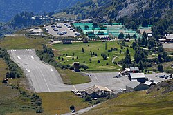
An altiport is an aerodrome for small airplanes and helicopters, situated on or within mountainous terrain. Altiports are generally characterized by having a runway with an atypical slope to fit in the local topography. Ultimately, this slope helps aircraft decelerating when landing and assists acceleration during takeoff. High altitude results in less lift available to aircraft wings, which requires aircraft to achieve higher speed at takeoff and landing. Such airfields with unusual physical characteristics are frequent in regions such as the French Alps, [1] Himalayan regions, as well as Pacific islands.

Contents

Definitions

According to ICAO Document 9150: STOLport Manual: "An altiport may be defined as a small airport in a mountainous area with a steep gradient runway, used for landing up the slope and for take-off down the slope, thereby making use of only one approach/departure area." [2]

According to the former French Technical Instruction on Civil Aerodromes (ITAC) of 2000, an altiport is specifically designed for serving mountainous regions. It features a steep runway that has a single approach/departure path. The runway ends with a section that has a lower slope, as well as an apron with aircraft stands. An altisurface is defined as a graded area that is not an aerodrome but that can be used as a steep runway with a single approach/departure path. [3]

List of altiports

Courchevel Altiport, showing the sloped runway Altiport Courchevel2.jpg
Courchevel Altiport, showing the sloped runway
AltiportCountry
Alpe d'Huez Airport France
Courchevel Altiport France
Corlier Aerodrome France
La Rosière, Savoie France
La Motte-Chalancon Airport  [ fr ]France
Megève Altiport France
Méribel Altiport France
Peyragudes Altiport (Altiport 007)  [ fr ]France
Tignes Altiport France
Valloire Airport  [ fr ]France
Ua Pou Airport French Polynesia (France)
Koro Airport Fiji
Tenzing–Hillary Airport Nepal

Related Research Articles

<span class="mw-page-title-main">Air traffic control</span> Public service provided for the purpose of maintaining the safe and orderly flow of air traffic

Air traffic control (ATC) is a service provided by ground-based air traffic controllers who direct aircraft on the ground and through a given section of controlled airspace, and can provide advisory services to aircraft in non-controlled airspace. The primary purpose of ATC worldwide is to prevent collisions, organize and expedite the flow of air traffic, and provide information and other support for pilots.

<span class="mw-page-title-main">Runway</span> Area of surface used by aircraft to takeoff from and land on

According to the International Civil Aviation Organization (ICAO), a runway is a "defined rectangular area on a land aerodrome prepared for the landing and takeoff of aircraft". Runways may be a human-made surface or a natural surface. Runways, taxiways and ramps, are sometimes referred to as "tarmac", though very few runways are built using tarmac. Takeoff and landing areas defined on the surface of water for seaplanes are generally referred to as waterways. Runway lengths are now commonly given in meters worldwide, except in North America where feet are commonly used.

<span class="mw-page-title-main">STOL</span> Class of airplanes that are designed to takeoff and land in a short distance

A short takeoff and landing (STOL) aircraft is a conventional fixed-wing aircraft that has short runway requirements for takeoff and landing. Many STOL-designed aircraft also feature various arrangements for use on airstrips with harsh conditions. STOL aircraft, including those used in scheduled passenger airline operations, have also been operated from STOLport airfields which feature short runways.

<span class="mw-page-title-main">Instrument landing system</span> Ground-based visual aid for landing

In aviation, the instrument landing system (ILS) is a precision radio navigation system that provides short-range guidance to aircraft to allow them to approach a runway at night or in bad weather. In its original form, it allows an aircraft to approach until it is 200 feet (61 m) over the ground, within a 12 mile (800 m) of the runway. At that point the runway should be visible to the pilot; if it is not, they perform a missed approach. Bringing the aircraft this close to the runway dramatically increases the range of weather conditions in which a safe landing can be made. Other versions of the system, or "categories", have further reduced the minimum altitudes, runway visual ranges (RVRs), and transmitter and monitoring configurations designed depending on the normal expected weather patterns and airport safety requirements.

<span class="mw-page-title-main">Heliport</span> Airport designed for helicopter use

A heliport, sometimes termed a vertiport, is a small airport suitable for use by helicopters and various types of vertical lift aircraft. Designated heliports typically contain one or more touchdown and liftoff areas and may also have limited facilities such as fuel or hangars. In some larger towns and cities, customs facilities may also be available.

<span class="mw-page-title-main">Airfield traffic pattern</span> Standard aircraft path

An airfield traffic pattern is a standard path followed by aircraft when taking off or landing while maintaining visual contact with the airfield.

Aviation is the design, development, production, operation, and use of aircraft, especially heavier-than-air aircraft. Articles related to aviation include:

<span class="mw-page-title-main">Aerodrome</span> Location from which aircraft flight operations take place

An aerodrome or airdrome is a location from which aircraft flight operations take place, regardless of whether they involve air cargo, passengers, or neither, and regardless of whether it is for public or private use. Aerodromes include small general aviation airfields, large commercial airports, and military air bases.

The visual approach slope indicator (VASI) is a system of lights on the side of an airport runway threshold that provides visual descent guidance information during final approach. These lights may be visible from up to 8 kilometres (5.0 mi) during the day and up to 32 kilometres (20 mi) or more at night.

<span class="mw-page-title-main">Precision approach path indicator</span> Visual aid in aviation

A precision approach path indicator (PAPI) is a system of lights on the side of an airport runway threshold that provides visual descent guidance information during final approach. It is generally located on the left-hand side of the runway approximately 300 meters beyond the landing threshold of the runway.

<span class="mw-page-title-main">Barra Airport</span> Airport located on the island of Barra in the Outer Hebrides, Scotland

Barra Airport is a short-runway airport situated in the wide shallow bay of Traigh Mhòr at the northern tip of the island of Barra in the Outer Hebrides, Scotland. The airport is unique, believed to be the only one in the world where scheduled flights use a tidal beach as the runway. The airport is operated by Highlands and Islands Airports Limited, which owns most of the regional airports in mainland Scotland and the outlying islands. Barra Airport opened in 1936. The airport's only destination is Glasgow.

A maneuvering area is that part of an aerodrome to be used by aircraft for takeoff, landing, and taxiing, excluding aprons and areas designed for maintenance of an aircraft.

<span class="mw-page-title-main">Elstree Aerodrome</span> Air Strip in Elstree, Hertfordshire

London Elstree Aerodrome is an operational general aviation aerodrome located in Elstree, and is situated 2.6 nautical miles east of Watford, Hertfordshire, England.

A STOLport or STOLPORT was an airport designed with STOL operations in mind, usually for an aircraft class of a certain weight and size. The term "STOLport" did not appear to be in common usage as of 2008, although was commonly used by pilots flying into Biggin Hill during 1986/87 when the London City Airport was opened restricting approaches and ceilings to the north of Biggin. A STOLport usually has a short single runway, generally shorter than 1,500 m (5,000 ft). STOLports are only practicable by certain types of aircraft, especially smaller propeller aircraft, with performances that are compatible with the shorter runway length, steeper approach/departure paths, etc. at individual STOLports. In the United States, short runway facilities are simply known as airports, and the term "STOLport" has not been commonly used since the early 1970s.

<span class="mw-page-title-main">Final approach</span> Final stage in an aircrafts approach to landing

In aeronautics, the final approach is the last leg in an aircraft's approach to landing, when the aircraft is lined up with the runway and descending for landing. In aviation radio terminology, it is often shortened to "final".

<span class="mw-page-title-main">Mustique Airport</span> Airport in Mustique, Saint Vincent and the Grenadines

Mustique Airport is a private airfield owned by the Mustique Company for public use and is located on Mustique island, part of Saint Vincent and the Grenadines in the Caribbean Sea. It is used by civil aviation and national airlines using turboprop planes.

<span class="mw-page-title-main">V speeds</span> Standard terms to define airspeeds

In aviation, V-speeds are standard terms used to define airspeeds important or useful to the operation of all aircraft. These speeds are derived from data obtained by aircraft designers and manufacturers during flight testing for aircraft type-certification. Using them is considered a best practice to maximize aviation safety, aircraft performance, or both.

<span class="mw-page-title-main">Courchevel Altiport</span> Dangerous airport in Courchevel, France

Courchevel Altiport is an altiport serving Courchevel, a ski resort in the French Alps. The airfield has a very short runway of only 537 metres (1,762 ft) with a gradient of 18.6%. There is no go-around procedure for landings at Courchevel due to the surrounding mountainous terrain. The airfield primarily sees use by smaller fixed-wing aircraft such as the Cessna 208 Caravan or Pilatus PC-12, as well as helicopters. The runway has no instrument approach procedure or lighting aids, making landing in fog or low clouds unsafe and almost impossible.

<span class="mw-page-title-main">Méribel Altiport</span> Airport in Les Allues

Méribel Altiport, is an altiport in Les Allues, a commune in Savoie, France.

<span class="mw-page-title-main">Union Island Airport</span> Airport in Clifton

Union Island Airport is the airport serving Union Island, Grenadines Parish, Saint Vincent and the Grenadines. It is located about 0.25 miles (0.40 km) from the town of Clifton, one of the country's main tourist centers and a major destination for charter leisure flights during the winter holiday season and Easter, for "Easterval" celebration. The airport serves as a focus city for flag carrier SVG Air and features flights to several short-haul regional destinations. It is the southmost airport of St. Vincent and the Grenadines.

References

  1. Flying Magazine, November 1975, page 5
  2. ICAO (1991). "STOLport Manual", Foreword, Document 9150, 2nd edition, page iii
  3. DGAC (2000). "Instruction technique sur les aérodromes civils" (ITAC), Chapitre 13 : Aérodromes à caractéristiques spéciales, 13-1 Altiports, page 13-3