
Las Vegas, often known simply as Vegas, is the 25th-most populous city in the United States, the most populous city in the state of Nevada, and the county seat of Clark County. The city anchors the Las Vegas Valley metropolitan area and is the largest city within the greater Mojave Desert. Las Vegas is an internationally renowned major resort city, known primarily for its gambling, shopping, fine dining, entertainment, and nightlife. The Las Vegas Valley as a whole serves as the leading financial, commercial, and cultural center for Nevada.

Nye County is a county in the U.S. state of Nevada. As of the 2010 census, the population was 43,946. Its county seat is Tonopah. At 18,159 square miles (47,030 km2), Nye is Nevada's largest county by area and the third-largest county in the contiguous United States, behind Coconino County of Arizona and San Bernardino County of California.
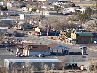
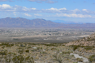
Beatty is an unincorporated town along the Amargosa River in Nye County in the U.S. state of Nevada. U.S. Route 95 runs through the town, which lies between Tonopah, about 90 miles (140 km) to the north and Las Vegas, about 120 miles (190 km) to the southeast. State Route 374 connects Beatty to Death Valley National Park, about 8 miles (13 km) to the west.

The Las Vegas Valley is a major metropolitan area in the southern part of the U.S. state of Nevada, and the second largest in the Southwestern United States. The state's largest urban agglomeration, the Las Vegas Metropolitan Statistical Area is coextensive since 2003 with Clark County, Nevada. The Valley is largely defined by the Las Vegas Valley landform, a 600 sq mi (1,600 km2) basin area surrounded by mountains to the north, south, east and west of the metropolitan area. The Valley is home to the three largest incorporated cities in Nevada: Las Vegas, Henderson and North Las Vegas. Eleven unincorporated towns governed by the Clark County government are part of the Las Vegas Township and constitute the largest community in the state of Nevada.

The Funeral Mountains are a short, arid mountain range in the United States along the California-Nevada border approximately 100 mi (160 km) west of Las Vegas. The mountains are considered a subrange of the Amargosa Range that form the eastern wall of Death Valley.

The Amargosa River is an intermittent waterway, 185 miles (298 km) long, in southern Nevada and eastern California in the United States. It drains a high desert region, the Amargosa Valley in the Amargosa Desert northwest of Las Vegas, into the Mojave Desert, and finally into Death Valley where it disappears into the ground aquifer. Except for a small portion of its route in the Amargosa Canyon in California and a small portion at Beatty, Nevada, the river flows above ground only after a rare rainstorm washes the region. A 26-mile (42 km) stretch of the river between Shoshone and Dumont Dunes is protected as a National Wild and Scenic River. At the south end of Tecopa Valley the Amargosa River Natural Area protects the habitat.
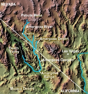
The Amargosa Valley is the valley through which the Amargosa River flows south, in Nye County, southwestern Nevada and Inyo County in the state of California. The south end is alternately called the "Amargosa River Valley'" or the "Tecopa Valley." Its northernmost point is around Beatty, Nevada and southernmost is Tecopa, California, where the Amargosa River enters into the Amargosa Canyon.

Rhyolite is a ghost town in Nye County, in the U.S. state of Nevada. It is in the Bullfrog Hills, about 120 miles (190 km) northwest of Las Vegas, near the eastern boundary of Death Valley National Park. The town began in early 1905 as one of several mining camps that sprang up after a prospecting discovery in the surrounding hills. During an ensuing gold rush, thousands of gold-seekers, developers, miners and service providers flocked to the Bullfrog Mining District. Many settled in Rhyolite, which lay in a sheltered desert basin near the region's biggest producer, the Montgomery Shoshone Mine.

The Amargosa Range is a mountain range in Inyo County, California and Nye County, Nevada. The 110-mile (180 km) range runs along most of the eastern side of California's Death Valley, separating it from Nevada's Amargosa Desert. The U-shaped Amargosa River flows clockwise around the perimeter of the range, ending 282 feet (86 m) below sea level in the Badwater Basin.

Death Valley Junction, more commonly known as Amargosa, is a tiny Mojave Desert unincorporated community in Inyo County, California, at the intersection of SR 190 and SR 127, in the Amargosa Valley and just east of Death Valley National Park. The zip code is 92328, the elevation is 2,041 ft (622 m), and the population is fewer than four people.
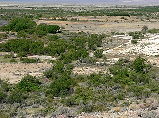
The Ash Meadows National Wildlife Refuge is a protected wildlife refuge located in the Amargosa Valley of southern Nye County, in southwestern Nevada. It is directly east of Death Valley National Park, and is 90 mi (140 km) west-northwest of Las Vegas.

The Amargosa Desert is located in Nye County in western Nevada, United States, along the California–Nevada border, comprising the northeastern portion of the geographic Amargosa Valley, north of the Ash Meadows National Wildlife Refuge.
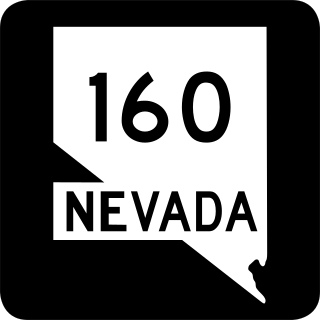
State Route 160 is a state highway in southern Nevada, United States. It connects the southern Las Vegas Valley to U.S. Route 95 northwest of the city via the Pahrump Valley. The southern part of the route sees heavy traffic, mostly due to Pahrump's continued growth as a Las Vegas bedroom community.

State Route 373 is a 16.304-mile-long (26.239 km) state highway in Nye County, Nevada, United States. It is a highway connecting California State Route 127 to U.S. Route 95, providing southern Nye County access to the eastern areas of Death Valley National Park.

The Bullfrog Hills are a small mountain range of the Mojave Desert in southern Nye County, southwestern Nevada. Bullfrog Hills was so named from a fancied resemblance of its ore to the color of a bullfrog.

Pahrump is an unincorporated town located at the southernmost tip of Nye County, Nevada, United States, about 62 miles (100 km) west of Las Vegas, Nevada. Pahrump lies adjacent to the Nevada–California border and the area had a population of 44,738 as of the 2020 census.

Bullfrog is a ghost town in Nye County, in the U.S. state of Nevada. It is located at the north end of the Amargosa Desert about 4 miles (6.4 km) west of Beatty. Less than 1 mile (1.6 km) north of Bullfrog are the Bullfrog Hills and the ghost town of Rhyolite. The two ghost towns are about 120 miles (190 km) northwest of Las Vegas, 60 miles (97 km) south of Goldfield, and 90 miles (140 km) south of Tonopah.
Pahrump Valley is a Mojave Desert valley west of Las Vegas and the Spring Mountains massif in southern Nye County, Nevada, and eastern San Bernardino County, California. Pahrump, Nevada, is in the valley's center and the Tecopa and Chicago Valleys are immediately to the west. The valley has routes to Death Valley and a route to Las Vegas. Pahrump Valley Days is the annual event in February each year, along with the sanctioned JRH-HS Rodeo.


