Ambegaon taluka

Last updated
Ambegaon
Taluka
Shree Harishchandra Mahadev Mandir - panoramio (7).jpg
Harishchandra Mahadev Mandir, Ghodegaon
Ambegaon tehsil in Pune district.png
India Maharashtra location map.svg
Red pog.svg
Ambegaon
Coordinates: 19°2′5″N73°50′11″E / 19.03472°N 73.83639°E / 19.03472; 73.83639
Country Flag of India.svg  India
State Maharashtra
District Pune
Headquarter Ghodegaon
Government
  MLADilip Walse Patil
Population
 (2011)
  Total235,972
Time zone UTC+5:30 (IST)

Ambegaon taluka is a taluka in Shirur subdivision of Pune district of state of Maharashtra in India. [1] One of the twelve most revered Shiva temples or Jyotirlinga, the Bhimashankar Temple is in Khed taluka. But due to Bhimashankar Sanctuary, the road is through Ambegaon taluka.

Contents

Geography

The Taluka lies at the foothills of eastern side of the Sahyadri Mountain range, and towards the west side of Pune city. The taluka's administrative limits are from the cities of Bhimashankar in North to Loni in its South and from Peth in East to Kalamb in its West direction. This taluka is geographically divided in two parts due to the patterns of rainfall. The northern region gets far less rainfall than mountainous southern side of the taluka. The rivers Meena, Ghodnadi and Vellnadi flow through the area.

2014 Malin landslide

In 2014, a serious mudslide around the village of Malin killed around 200 people. The landslides were caused by heavy rainfall that began a day prior, with the village receiving 10.8 cm (4 in) of rain on 29 July of that year and the downpour continuing throughout the following day. The environmental factors that resulted in the landslide is believed to have had more than one cause. One major cause was negligence of geological facts of the area before any construction or civil developmental process. Another cause cited for contributing to the landslide was rapid deforestation in the area. [2] Deforestation removes not only trees, but also root structures that hold together the soil.[ citation needed ] Through deforestation, the soil of the surrounding land was made soft, and experts argue that deforestation was the primary underlying anthropogenic cause of the landslide. [3] One additional reason was changing agricultural practices  villagers had then recently shifted from cultivation of rice and finger millet to wheat, which required leveling of steep areas, which contributed to instability of the hills. Also the construction of the Dimbhe Dam ten years ago near this area was considered as a contributing factor. The instability of the hillsides was due to the construction activities, which are often done without careful analysis of environmental consequences. [4] Stone quarrying, among other types of construction, was specifically blamed for the instability of the hillside. [5]

Flora and fauna

Deciduous Forests cover area around Bhimashankar. The Forests in the area have trees like Teak, Oak, Mango. The forest inhabits animals like Rabbit, Deer, Wolf, Fox, Tiger and Leopards. Birds found in the area include Peacock, Bulbul, and Parrot. Bhimashankar Wildlife Sanctuary was created in the area in order to protect the habitat of the Indian Giant Squirrel. Its area is 131 km2 (51 sq mi) and is a part of the Western Ghats (Sahyadri Ranges). This sanctuary was created in 1984 and includes 9 tribal villages. This area's biodiversity has been retained as it will be preserved as a cluster of sacred groves for generations. [6] These sacred groves act as gene pools of this area, from where seeds were dispersed. Inside the Ahupe village's sacred grove in the sanctuary (where a tribe of Mahadev Koli resides) in 1984, a climber plant called Khombhal or Xantolis tomentosa was found to be 8001000 years old. [7]

Demographics

Religions in Ambegaon taluk (2011) [8]
ReligionPercent
Hinduism
94.81%
Islam
6.19%
Buddhism
1.81%
Jainism
0.55%
Other or not stated
0.29%

Ambegaon taluka has a population of 235,972 according to the 2011 census. Ambegaon had a literacy rate of 82.94% and a sex ratio of 979 females per 1000 males. 24,375 (10.33%) are under 7 years of age. 18,876 (8.00%) lived in urban areas. Scheduled Castes and Scheduled Tribes make up 4.13% and 21.49% of the population respectively. [9]

Languages of Ambegaon taluk (2011) [10]

   Marathi (94.24%)
   Hindi (2.34%)
   Urdu (1.04%)
  Others (2.38%)

At the time of the 2011 Census of India, 94.24% of the population in the district spoke Marathi, 2.34% Hindi and 1.04% Urdu as their first language. [10]

The taluka has 142 villages from which the two towns of Manchar and Ghodegaon have a sizable population.

Villages

Economy

Agriculture is the main occupation of this region. Rivers like Ghod and Dhimbe provide water for cultivation. Dhimbe dam allows irrigation for cash crops. The most commonly grown crop is millet and vegetables like Potato are commonly grown too. In northern region, wheat, Jawari (also known as Durra) and Bajari (Pearl millet) are most commonly grown crops whereas in southern region rice is grown. Tomato and fruits like Grapes and Banana are also grown. The cultivated area of the taluka is approximately 87851 hectares. Significant crops are in the table below:

Oil pressing (extracting) plants & refineries are also found in the region. Recently a new sugar factory has been constructed named as Bhimashankar sakhar karkhana. The taluka also has a sizeable dairy industry. There are 197 organisations in the area related to milk production.

Transport

National Highway no. 50 linking the cities of Pune and Nasik goes through the taluka. There is also a State Highway linking cities of Shirur to Bhimashankar via Manchar. At present there are no rail links in the taluka.

Education

Primary and secondary education

State Primary Schools in the Taluka are run by the Zila parishad. Private schools along with secondary schools in the taluka are run by charitable trusts. All schools are required to undergo mandatory inspection by the Zila parishad. [11] Mode of instruction is either in Marathi or English. The secondary schools are affiliated with either of the boards, the Council for the Indian School Certificate Examinations (CISCE), the Central Board for Secondary Education (CBSE), the National Institute of Open School (NIOS) or the Maharashtra State Board of Secondary and Higher Secondary Education. Under the 10+2+3 plan, after completing secondary school, students typically enroll for two years in a junior college, also known as pre-university, or in schools with a higher secondary facility affiliated with the Maharashtra State Board of Secondary and Higher Secondary Education or any central board. The taluka has 2 High schools, 23 Central Schools, 222 Primary Schools, 5 Ashram-run schools and 74 pre-school nurseries run by the Zila Parishad. Reputed schools in the taluka are Mahatma Gandhi Junior College of Science in the town of Manchar and Janta Vidya Mandir in Ghodegaon.

Vocational training

The town of Ghodegaon has a post Secondary School Industrial training institutes (ITI) run by the government that offer vocational training in numerous trades such as construction, plumbing, welding, automobile mechanics, etc. Successful candidates receive the National Trade Certificate. [12]

Higher Education

Annasaheb Awate college run by the Rayat Shikshan Sanstha in Manchar is the institution that offers Degree and Masters level courses in the Taluka. Also The B.D. Kale college in Ghodegaon also Popular in Ambegaon. The college is affiliated to the Savitribai Phule Pune University. Institutes for Higher Technical Education in Ambegaon, are the Government Polytechnic College in Awasari, the Government College of Engineering & Research in Awasari Kd, and Dattatray Govindrao Walase Patil College for Higher Education run by the Bhimashankar Shikshan Sanstha in Pargaon (Shingave).

Culture

Bullock cart race at a festival in Manchar Bailgada manchar.png
Bullock cart race at a festival in Manchar

Ganesh Utsav, Navratri, and many such auspicious festivals are also celebrated here with great enthusiasm. Janta Utsav is one of the unique festivals of this region where functions like yatra, wrestling, tamasha and numerous religious programmes are held by various Mandals. Bullock-cart races are an inseparable part of this taluka which is also very prominent throughout Maharashtra. Lots of tribe reside in Ambegaon they celebrate with their tradition and culture.

Hindu Temples and places of pilgrimage in the region

Bhimashankar Temple, one of the twelve holiest Jyotirlinga Temples BhimaShankar - panoramio (11).jpg
Bhimashankar Temple, one of the twelve holiest Jyotirlinga Temples

Places of Historical Importance and Recreation

See also

Related Research Articles

<span class="mw-page-title-main">Bhimashankar Temple</span> Jyotirlinga in Maharashtra

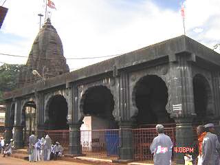
The BhimashankarMandir is a Shiva mandir situated in its eponymous village, Bhimashankar, in Pune district of Maharashtra. It is a key pilgrimage centre and one of the 12 Jyotirlinga in the world. The temple's Shiva lingam is one of the three Jyotirlinga of Maharashtra. The mandir is situated on a mountain. It is 110 kilometers away from Pune. The temple's vicinity has rare plant and animal species. The mandir is located in Khed taluka, in the Bhimashankar forest range.

<span class="mw-page-title-main">Bhima River</span> Major river in southwest India

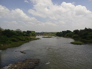
The Bhima River is a major river in Western India and South India. It flows southeast for 861 kilometres (535 mi) through Maharashtra, Karnataka, and Telangana states, before joining the Krishna River. After the first sixty-five kilometers in a narrow valley through rugged terrain, the banks open up and form a fertile agricultural area which is densely populated.

<span class="mw-page-title-main">Pune district</span> District in Maharashtra, India

Pune district is a district in Western Maharashtra with Administrative Headquarters in Pune city. Pune district is the most populous district in the Indian state of Maharashtra. It is one of the most industrialised districts in India.

Gadhinglaj ([ɡəɖᵊɦiŋɡləd͡z]) is a city in India in the Kolhapur district in the southwest corner of the state of Maharashtra, India. It is located on the banks of the river Hiranyakeshi. It is the Taluka (Tehsil) headquarters of Gadhinglaj Taluka and a subdivision headquarters of the Gadhinglaj Subdivision of the Kolhapur District. It is governed by a municipal council. The rapidly growing city is the third largest in the Kolhapur District, with population of more than 50,000. Places to visit like Samagad fort, temples and beautiful weather.

Manchar is a census town and Nagar panchayat in Ambegaon taluka of Pune district in the Indian state of Maharashtra. Nearby villages are Kalamb, Pimpalgoan, and Landewadi. It is governed by Manchar Nagar Panchayat which is second Nagar panchayat in the Pune district.

Shirur is an administrative subdivision of the Pune district in the Indian state of Maharashtra. It is located on the eastern boundary of the district, on the banks of the Ghod River. The town is also called Ghodnadi to distinguish it from other locations that have the same name. Ghodnadi in Marathi Language means Ghod River.

Bhimashankar Wildlife Sanctuary was created in the Ambegaon and Khed talukas of Pune District, in the Western Indian state of Maharashtra in order mainly to protect the habitat of the Indian Giant Squirrel.

<span class="mw-page-title-main">Chas Ghodegaon</span> Small Town in Maharashtra, India

Chas is a small town on the banks of the river Ghod River in Ambegaon taluka of Pune district in the Indian state of Maharashtra, India.

<span class="mw-page-title-main">Hemadpanti architecture</span> Temple Architecture of Medieval Hindustan

Hemadpanti Sculpture is an architectural style, named after its founder, the prime minister Hemadpant of the court of Seuna Yadavas of Devagiri.

<span class="mw-page-title-main">Mulshi taluka</span> Tehsil in Maharashtra, India

Taluka Mulshi is a taluka in Maval subdivision of Pune district of state of Maharashtra in India. Mulshi consists of Pune Metropolitan Region & Villages.

Sherikasari is a newly separated small village from Alkuti village of Parner Taluka in Ahmednagar District of state of Maharashtra, India.

Kalwadi is a village in Junnar taluka, Pune district, of Maharashtra, India situated adjuscent to the Kukadi River and Yedgaon Dam.

Kavathe is a village located in Shirur Taluka of the Pune district of Maharashtra state. The village adds the name of local hindu goddess 'Yemai' for distinguishing from other villages in Maharashtra with similar name. Kavathe is known for it historical link with Maratha Empire and because of various folk art & artiste associated with Tamasha, drama, Jagaran-Gondhal and Bharud. Poet Bashir Momin Kavathekar and Dholak performer Shri Gangaram Bua are the two prominent folk artiste who had brought laurels with their notable contribution to the Maharashtra's performing art, culture and traditional art form Tamasha. Vithabai Bhau Mang Narayangaonkar's grandfather Shri Narayan Khude who formed his own Tamasha Troupe was also from Kavathe Yamai.

<span class="mw-page-title-main">2014 Malin landslide</span> Natural disaster in Pune, Maharashtra, India

On 30 July 2014, a landslide occurred in the village of Malin in the Ambegaon taluka of the Pune district in Maharashtra, India. The landslide, which hit early in the morning while residents were asleep, was believed to have been caused by a burst of heavy rainfall, and killed at least 151 people. Rains continued after the landslide making rescue efforts difficult.

<span class="mw-page-title-main">Chandoli Budruk</span> Village in Maharashtra

Chandoli Budruk is a village in Ambegaon Taluka of Pune district in the Indian state of Maharashtra. According to 2011 Census the population of Chandoli Budruk is 3,546 out of which 1,777 are male and 1,769 are females. There are total 692 houses in Chandoli Budruk. The GP Code of Chandoli Budruk is 185274 and PIN Code is 410 503.

Awasari Bk is a village in Ambegaon taluka of Pune District in the state of Maharashtra, India.The village is administrated by a Sarpanch who is an elected representative of village as per constitution of India and Panchayati raj (India).

Dhamani is a village in Ambegaon taluka of Pune District in the state of Maharashtra, India. The village is administrated by a Sarpanch who is an elected representative of village as per constitution of India and Panchayati raj (India).

Dimbhe Kh is a village in Ambegaon taluka of Pune District in the state of Maharashtra, India. The village is administrated by a Sarpanch who is an elected representative of village as per constitution of India and Panchayati raj (India).

Dhamani is a village in Ambegaon taluka of Pune District in the state of Maharashtra, India. The village is administrated by a Sarpanch who is an elected representative of village as per constitution of India and Panchayati raj (India).

References

  1. "Talukas in Pune district". Archived from the original on 10 March 2010.
  2. "Rain-triggered landslide buries homes in remote Indian village, killing at least 17". U.S. News & World Report. Associated Press. 30 July 2014. Retrieved 30 July 2014.
  3. "The real reason for Pune village landslide: Forest was cleared for a govt scheme". Firstpost. Retrieved 2016-03-01.
  4. Mazoomdaar, Jay (31 July 2014). "Is India's construction boom behind Pune village landslide?". BBC. BBC News. Retrieved 1 August 2014.
  5. "Indian media: Deforestation behind deadly Pune landslide". BBC. BBC News. 31 July 2014. Retrieved 1 August 2014.
  6. Deo, Sharmila. "The Environment Education Programme in Bhimashankar Wildlife Sanctuary". Kalpavriksh Environmental Action Group.
  7. Karnik, Kusum (2003-02-21). "Guardians of the Forest". aseanbiodiversity.info. Shaswat Trust. Archived from the original on 2016-03-03. Retrieved 2011-02-06.
  8. "Table C-01 Population by Religion: Maharashtra". censusindia.gov.in. Registrar General and Census Commissioner of India. 2011.
  9. "District Census Hand Book – Pune" (PDF). Census of India . Registrar General and Census Commissioner of India.
  10. 1 2 "Table C-16 Population by Mother Tongue: Maharashtra". censusindia.gov.in. Registrar General and Census Commissioner of India.
  11. Joshi, R., Regulatory Requirements for Starting a School in Poona.Centre for Civil Society, CCS RESEARCH INTERNSHIP PAPERS 2004 Archived 2017-10-03 at the Wayback Machine
  12. Melsens, S; Mangaonkar-Vaiude, P; Bertels, Inge (2017). Campbell, James; et al. (eds.). Building Histories: the Proceedings of the Fourth Annual Construction History Society Conference. Cambridge, UK: The Construction History Society. pp. 27–38. ISBN   978-0992875138 . Retrieved 3 October 2017.