Amirante Islands

Last updated
Amirante Islands
Nickname: Ilhas do Almirante
Amirantes-Sat.png
Satellite Image Map, with neighbouring Alphonse Group in the lower left
Seychelles location map.svg
Red pog.svg
Amirante Islands
Location of Amirante Islands in Seychelles
Geography
Location Indian Ocean
Coordinates 04°49′S53°40′E / 4.817°S 53.667°E / -4.817; 53.667 Coordinates: 04°49′S53°40′E / 4.817°S 53.667°E / -4.817; 53.667
Archipelago Seychelles
Adjacent bodies of water Indian Ocean
Total islands20
Major islands
Area11.5 km2 (4.4 sq mi)
Highest elevation15 m (49 ft)
Administration
Group Outer Islands
Sub-Group Amirante Islands
Districts Outer Islands District
Largest settlement Île Desroches (pop. 40)
Demographics
Population300 (2014)
Pop. density26/km2 (67/sq mi)
Ethnic groups Creole, French, East Africans, Indians.
Additional information
Time zone
ISO code SC-26
Official website www.seychelles.travel/en/discover/the-islands/outer-islands

The Amirante Islands (Les Amirantes) are a group of coral islands and atolls that belong to the Outer Islands of the Seychelles.

Contents

They stretch about 155 km from the African Banks (African Islands) in the north to Desnœufs (Isle des Noeufs) in the south, all on the shallow Amirantes Bank (Amirantes Plateau, with depths of mostly 25 to 70 m), except the main island Île Desroches in the east, and submerged Lady Denison-Pender Shoal at the northern end. 90 km south of the Amirante Islands is Alphonse Group, the closest group of islands, which are sometimes considered part of the Amirantes.

History

The Amirantes were discovered by Vasco da Gama on his second voyage of exploration in 1503, and later named "Ilhas do Almirante" (Admiral Islands). Previous knowledge of the islands by Arab and Indian traders is possible. The islands were claimed by Sieur Michel Blin for France in 1802. By the Treaty of Paris (1814), the islands were passed officially to the British, as a part of Mauritius. In 1909, the Seychelles became a separate colony, thereby including the Amirantes. On 8 November 1965 the United Kingdom split Île Desroches from the Seychelles to become part of the newly created British Indian Ocean Territory. The purpose was to allow the construction of a military base for the mutual benefit of the United Kingdom and the United States. On 23 June 1976 Île Desroches was returned to the Seychelles as a result of it attaining independence.

The total land area is 11.5 km2. The total population is 300. The biggest concentrations are the Prison 2 km from Marie Louise village and the Collins group construction camp which is 2 km from the capital village of Desroches village (which had a population of 35 in the last census).

Islands

There are eight single islands (five low sand cays and three uplifted sand cays), plus three atolls with a total of 18 islets (St. Joseph Atoll with 14, Desroches with 1, Poivre Atoll with 3). In addition to these 11 units, the following table also has entries for a reef and a shoal without islets, for the sake of completeness. The five largest ones in area are inhabited. The different island types are marked by different background colours in the table.

 Island/Atoll/Reef
(alternate name)
typeArea
(km2)
Pop.
est.
Location
1 Lady Denison-Pender submerged shoal-- 04°49′S53°20′E / 4.817°S 53.333°E / -4.817; 53.333 (Lady Denison-Pender Shoal)
2 African Banks (African Islands)sand cay0.04- 04°53′S53°24′E / 4.883°S 53.400°E / -4.883; 53.400 (African Banks)
3 Remire Reef drying reef-- 05°05′S53°21′E / 5.083°S 53.350°E / -5.083; 53.350 (Remire Reef)
4 Remire (Eagle)uplifted sand cay0.276 05°07′S53°19′E / 5.117°S 53.317°E / -5.117; 53.317 (Remire Island)
5 D'Arros sand cay1.7142 05°24.5′S53°18′E / 5.4083°S 53.300°E / -5.4083; 53.300 (D'Arros Island)
6 St. Joseph atoll1.630 05°25′S53°20′E / 5.417°S 53.333°E / -5.417; 53.333 (Saint Joseph Atoll)
7 Bertaut sand cay0.002- 05°39′06″S53°14′18″E / 5.65167°S 53.23833°E / -5.65167; 53.23833 (Bertaut Reef)
8 Desroches atoll4.02100 05°41′S53°41′E / 5.683°S 53.683°E / -5.683; 53.683 (Île Desroches)
9 Poivre atoll2.7810 05°46′S53°19′E / 5.767°S 53.317°E / -5.767; 53.317 (Poivre Islands)
10 Étoile sand cay0.05- 05°53′S53°01′E / 5.883°S 53.017°E / -5.883; 53.017 (Étoile Cay)
11 Boudeuse sand cay0.03- 06°05′31″S52°49′50″E / 6.09194°S 52.83056°E / -6.09194; 52.83056 (Boudeuse Cay)
12 Marie Louise uplifted sand cay0.556150 06°11′S53°08′E / 6.183°S 53.133°E / -6.183; 53.133 (Marie Louise Island)
13 Desnœufs (Île des Noeufs)uplifted sand cay0.45- 06°14′S53°03′E / 6.233°S 53.050°E / -6.233; 53.050 (Île Desnœufs)
 Amirante Islandsisland chain11.530004°49' to 06°14'S,
52°50° to 53°41'E
Map all coordinates using: OpenStreetMap  
Download coordinates as: KML

Alphonse Group

90 km south of the Amirante Islands is Alphonse Group, the closest group of islands, which are sometimes considered part of the Amirantes chain because they are a southern continuation or extension of the Amirantes chain. Alphonse Group lies south of the Amirantes Bank, separated from it by deep water (generally 1000 to 2000 metres deep).

See also

Related Research Articles

Coral Sea Islands

The Coral Sea Islands Territory is an external territory of Australia which comprises a group of small and mostly uninhabited tropical islands and reefs in the Coral Sea, northeast of Queensland, Australia. The only inhabited island is Willis Island. The territory covers 780,000 km2 (301,160 sq mi), most of which is ocean, extending east and south from the outer edge of the Great Barrier Reef and includes Heralds Beacon Island, Osprey Reef, the Willis Group and fifteen other reef/island groups. Cato Island is the highest point in the Territory.

Lists of islands Wikipedia list article

This is a list of the lists of islands in the world grouped by country, by continent, by body of water, and by other classifications. For rank-order lists, see the other lists of islands below.

Geography of Seychelles

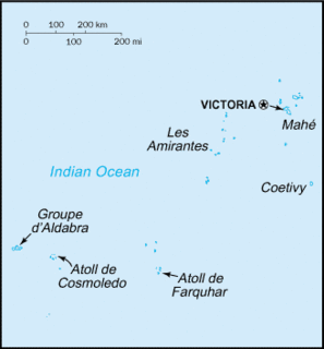
Seychelles is a small island country located in the Somali sea northeast of Madagascar and about 835 mi (1,344 km) from Mogadishu, Somalia, its nearest foreign mainland city, while Antsiranana is the nearest foreign city overall. Seychelles lies between approximately 4ºS and 10ºS and 46ºE and 54ºE. The nation is an archipelago of 115 tropical islands, some granite and some coral. the majority of which are small and uninhabited. The landmass is only 452 km2 (175 sq mi), but the islands are spread wide over an exclusive economic zone of 1,336,559 km2 (516,048 sq mi). About 90 percent of the population of 90,000 live on Mahé, 9 percent on Praslin and La Digue. Around a third of the land area is the island of Mahé and a further third the atoll of Aldabra.

Alphonse Atoll

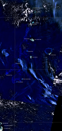
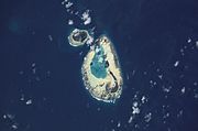
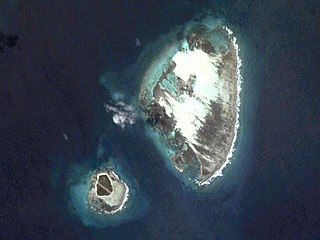
Alphonse Atoll is one of two atolls of the Alphonse Group, the other being St. François Atoll — both in the Outer Islands coral archipelago of the Seychelles.

Desroches Island Main island of the Amirante Islands, part of the Outer Islands of the Seychelles

Desroches Island or Île Desroches is the main island of the Amirante Islands, part of the Outer Islands of the Seychelles.

Outer Islands (Seychelles) Collective term for those islands of the Seychelles that are not on the shallow Seychelles Bank

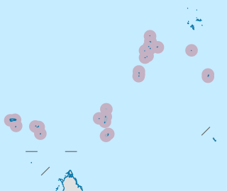
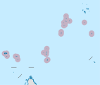
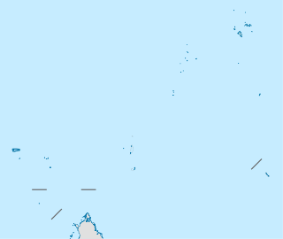
The Outer Islands or Coralline Seychelles (archipelago) is a collective term for those islands of the Seychelles that are not on the shallow Seychelles Bank which defines the location of the granitic Inner Islands archipelago to the east. The local Seychellois Creole name for the outer islands is Zil Elwannyen Sesel, while the French name is Îles Eloignées. They are all of coral formation, and in the western Indian Ocean.

Alphonse Group

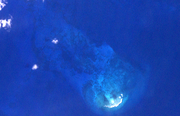
The Alphonse Group belong to the Outer Islands of the Seychelles, lying in the southwest of the island nation, 403 kilometres southwest the capital, Victoria, on Mahé Island. The closest island is Desnœufs Island of the Amirante Islands, 87 km (54 mi) further north.

DArros Island

D'Arros Island is part of the Amirante Islands group, which are in the Outer Islands coral archipelago of the Seychelles islands and nation. The island is located west of the granitic Inner Seychelles archipelago, with a distance of 255 km south of Victoria, Seychelles.

Cay Sal Bank Carbonate platform in Bahama Banks, The Bahamas

Cay Sal Bank is the third largest and the westernmost of the Bahama Banks. It is located between 23º27'N - 24º10'N and 079º25'W – 080º35'W. In a geographical sense, it is separate from the Bahamas proper as it is much closer to Cuba than to the closest Bahamian island. It is separated by Santaren Channel from the Great Bahama Bank, the western rim of which is 50 km (31 mi) to the east. The Straits of Florida separate it from the United States mainland and the Florida Keys.

Articles related to Seychelles include:

Marie Louise Island

Marie Louise Island is a low-lying coral island in the Amirantes group of the Outer Islands of the Republic of Seychelles, in the western Indian Ocean, with a distance of 308 km south-west of Victoria, Seychelles.

Dangerous Ground (South China Sea)

Dangerous Ground is a large area in the southeast part of the South China Sea characterized by many low islands and cays, sunken reefs, and atolls awash, with reefs often rising abruptly from ocean depths greater than 1000m.

African Banks

The African Banks are the uninhabited northernmost islands of the Amirante Islands, of the Outer Islands of the Republic of Seychelles, in the western Indian Ocean.

Desnoeufs Island

Desnœufs Island is an island in Seychelles, lying at the southern edge of the Amirantes group, in the Outer Islands, with a distance of 321 km south of Victoria, Seychelles.

Remire Reef

Remire Reef is a reef in Seychelles, lying in the Outer Islands of Seychelles, with a distance of 240 km southwest of Victoria, Seychelles.

St. Joseph Atoll

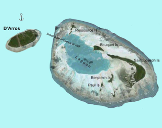
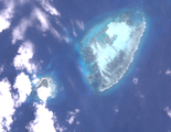
Saint Joseph Atoll is part of the Amirante Islands group, which are in the Outer Islands coral archipelago of the Seychelles islands and nation. The atoll is located southwest of the granitic Inner Seychelles archipelago, with a distance of 248 km south of Victoria, Seychelles.

Bertaut Reef

Bertaut Reef is an island in Seychelles, lying in the Outer Islands of Seychelles, with a distance of 271 kilometres south of Victoria, Seychelles.

Poivre Atoll

Poivre Islands are a group of islands in Seychelles, lying in the Outer Islands of Seychelles, with a distance of 268 km south of Victoria, Seychelles.

Étoile Cay

Étoile Cay is an uninhabited circular coral cay in Seychelles, lying in the Amirantes group of the Outer Islands of Seychelles, with a distance of 302 km south of Victoria, Seychelles.

References

    Amirante Islands on Birdlife International