
Hunterdon County is a county located in the western section of the U.S. state of New Jersey. As of the 2020 United States Census, the county's population was 128,947, making it the state's 18th-most populous county, representing an increase of 598 (0.5%) from the 128,349 enumerated in the 2010 United States Census, which in turn increased by 6,360 (5.2%) from the 121,989 counted in the 2000 Census. Its county seat is Flemington.
Route 31 is a state highway in New Jersey, United States. It runs 48.93 mi (78.75 km) from U.S. Route 1 Business /US 206 in Trenton, Mercer County, north to an intersection with US 46 in Buttzville in White Township, Warren County. Along the way, Route 31 heads through the communities of Flemington, Clinton and Washington. Most of the highway is state-maintained; however, the section within the city limits of Trenton is maintained by the city. Much of Route 31 is a two-lane highway that passes through farmland, woodland, and mountainous areas. Two portions of the route—from Trenton to Pennington and from Ringoes to Clinton—consist of more development.
Delaware Township is a township in Hunterdon County, New Jersey, United States. Part of the township is on the Hunterdon Plateau, while the southern portions are in the Amwell Valley. As of the 2010 United States Census, the township's population was 4,563, reflecting an increase of 85 (+1.9%) from the 4,478 counted in the 2000 Census, which had in turn declined by 34 (-0.8%) from the 4,512 counted in the 1990 Census.

East Amwell Township is a township in Hunterdon County, New Jersey, United States. As of the 2010 United States Census, the township's population was 4,013, reflecting a decline of 442 (-9.9%) from the 4,455 counted in the 2000 Census, which had in turn increased by 123 (+2.8%) from the 4,332 counted in the 1990 Census.

Flemington is a borough in Hunterdon County, New Jersey, United States. It is the county seat of Hunterdon County. As of the 2010 United States Census, the borough's population was 4,581, reflecting an increase of 381 (+9.1%) from the 4,200 counted in the 2000 Census, which had in turn increased by 153 (+3.8%) from the 4,047 counted in the 1990 Census. Most of the borough is located in the Amwell Valley and the Raritan Valley. Northwestern portions of the borough sit on the Hunterdon Plateau.

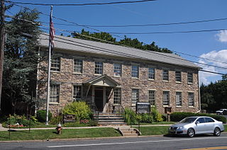
Raritan Township is a township in Hunterdon County, New Jersey, United States. As of the 2010 United States Census, the township's population was 22,185, reflecting an increase of 2,376 (+12.0%) from the 19,809 counted in the 2000 Census, which had in turn increased by 4,193 (+26.9%) from the 15,616 counted in the 1990 Census. The township is located within the heart of the Amwell Valley and Raritan Valley regions, as the South Branch of the Raritan River flows through the center of the township. The northwestern portion of the township is located on the Hunterdon Plateau.

Readington Township is a township located in the easternmost portion of Hunterdon County, New Jersey, United States. As of the 2010 United States Census, the township's population was 16,126, reflecting an increase of 323 (+2.0%) from the 15,803 counted in the 2000 Census, which had in turn increased by 2,403 (+17.9%) from the 13,400 counted in the 1990 Census.
The Flemington-Raritan Regional School District is a comprehensive regional public school district in eastern Hunterdon County, New Jersey, United States, which serves students in pre-kindergarten through eighth grades from the neighboring communities of Flemington Borough and Raritan Township.

Hunterdon Central Regional High School is a comprehensive, four-year public high school, and regional school district that serves students from five municipalities in east central Hunterdon County, New Jersey, United States. Students hail from Delaware Township, East Amwell Township, Flemington, Raritan Township and Readington Township.
The Readington Township Public Schools is a community public school district that serves students in pre-kindergarten through eighth grade from Readington Township, in Hunterdon County, New Jersey, United States.

The Ambush of Geary, also known as the Amwell Skirmish, was a skirmish of the American Revolutionary War fought on 14 December 1776 in Amwell Township of Hunterdon County, New Jersey. Cornet Francis Geary, the leader of a company of dragoons, was shot in an ambush set up by local militiamen led by Captain John Schenck.

John Schenck (1750–1823) was a captain in the New Jersey Militia during the American Revolutionary War.
The Delaware Township School District is a community public school district that serves students in pre-kindergarten through eighth grade from Delaware Township, in Hunterdon County, New Jersey, United States.
U.S. Route 202 (US 202) is a U.S. Highway running from New Castle, Delaware northeast to Bangor, Maine. In the U.S. state of New Jersey, the route runs 80.31 mi (129.25 km) from the New Hope–Lambertville Toll Bridge over the Delaware River at the Pennsylvania border in Delaware Township, Hunterdon County near Lambertville northeast to the New York border in Mahwah, Bergen County. Along the route's journey, it passes through a variety of suburban and rural environments, including the communities of Flemington, Somerville, Morristown, Parsippany-Troy Hills, Wayne, and Oakland as well as five counties: Hunterdon, Somerset, Morris, Passaic, and Bergen. US 202 encounters many major roads in New Jersey, including Route 31, US 206, US 22, Interstate 80 (I-80), US 46, Route 23, and Route 17. From Somerville to the New York border, US 202 generally runs within a close distance of I-287 and interchanges with that route several times. The road ranges from a four-lane freeway between Lambertville and Ringoes in Hunterdon County to a two-lane undivided road through much of the northern portion of the route. North of the Route 53 intersection in Morris Plains, US 202 is maintained by individual counties rather than the New Jersey Department of Transportation with a few exceptions.
The East Amwell Township School District is a community public school district that serves students in pre-kindergarten through eighth grade from East Amwell Township, in Hunterdon County, New Jersey, United States.

The Amwell Valley is a small valley in Hunterdon County, New Jersey, between the Hunterdon Plateau and the Sourlands. It comprises Stockton, parts of Delaware Township, West Amwell, East Amwell, Flemington and Raritan Township. The region borders the Delaware River to the west and the South Branch Raritan River to the east. The entire area has elevations around 200 feet above sea level. US 202 is the main route running west to east through the valley. Old York Road also passes through the valley, taking a generally more southern route through Raritan and along the Sourlands at Mount Airy. Like the Hunterdon Plateau, Amwell Valley still has a large number of farms due to its sufficient climate, relatively flat land and the presence of silt-loams soils. The valley is home to Unionville Winery and Old York Cellars in Ringoes.

Copper Hill is an unincorporated community located within the Amwell Valley of Raritan Township in Hunterdon County, New Jersey. It is located between Flemington and Ringoes along U.S. Route 202, New Jersey Route 31 and Copper Hill Road. It was named for the old copper mines in the area.

Flemington Junction is an unincorporated community located within Raritan Township in Hunterdon County, New Jersey, United States. The area is located approximately one and a half miles (2.4 km) northeast of downtown Flemington and was the site of the junction of the Lehigh Valley Railroad's Flemington Branch and Mainline. The Flemington Junction station was listed as part of the Raritan–Readington South Branch Historic District in 1990. Today, the Flemington Spur tracks have been removed but numerous industries and commercial businesses are located in the vicinity of the crossing. In addition to the Norfolk Southern rail line, County Route 523 passes through the area.
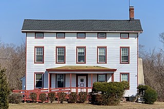
The Raritan–Readington South Branch Historic District is a 556-acre (225 ha) historic district along River Road from New Jersey Route 31 to U.S. Route 202 near Flemington in Hunterdon County, New Jersey. It is primarily on the western side of the South Branch Raritan River in Raritan Township. It extends onto the eastern side of the river in Readington Township. County Route 523 and County Route 612 pass through the district to the north. The district encompasses the small settlements of Holcomb Mills, Flemington Junction, and Rockefellows Mills. It was added to the National Register of Historic Places on January 26, 1990, for its significance in architecture, politics, transportation, and exploration/settlement. The district includes 36 contributing buildings, four contributing structures, and three contributing sites. It also includes the John Reading Farmstead, previously listed on the NRHP individually.


