Nauru, officially the Republic of Nauru and formerly known as Pleasant Island, is an island country and microstate in Micronesia, part of Oceania in the Central Pacific. Its nearest neighbour is Banaba of Kiribati, about 300 km (190 mi) to the east.
History of Nauru, is about Nauru, an island country in the Pacific Ocean. Human activity is thought to have begun roughly 3,000 years ago when clans settled the island. A people and culture developed on the island, the Nauru which had 12 tribes. At the end of the 1700s, a British ship came, and this was the first known contact with the outside world. The British ship called it "pleasant island" and it was a friendly greeting; the British sailed on. Thirty years later, in 1830, an escaped Irish convict took over the island and was finally evicted in 1841. There were scattered interactions with passing vessels and trade. In the mid-to-late 19th century, a devastating civil war started, which took the lives of many Nauru. This war was ended when Germany annexed the island in 1888, and negotiations ended the fighting. In the 1900s, phosphate mining started, and the Germans built some modern facilities on the island. German control ended at the end of World War I, and it was passed to Australia as protectorate. This continued until WW2, when the Empire of Japan invaded the island. Although it was occupied for a few years, many Nauru died at this time, and much of the population was deported from the island and/or used for slave labor. With the surrender of Japan, the Nauru were returned to the island, and it was put under Australian administration again, under the condition it would become independent. This happened in 1968, and Nauru has been a stable democracy since that time. In the last three decades of the 20th century, Nauru had enormous per capita wealth from the phosphate mining, to the point they were some of the richest people on the planet. However, when this ended and the investments were depleted, it has had a harder time, and international aid is important in the 21st century.
Nauru is a tiny phosphate rock island nation located in the South Pacific Ocean south of the Marshall Islands in Oceania. It is only 53 kilometres (33 mi) south of the Equator at coordinates 0°32′S166°55′E. Nauru is one of the three great phosphate rock islands in the Pacific Ocean—the others are Banaba in Kiribati and Makatea in French Polynesia.
Sumba, natively also spelt as Humba, Hubba, Suba, or Zuba is an Indonesian island located in the Eastern Indonesia and administratively part of the East Nusa Tenggara provincial territory. Sumba has an area of 11,243.78 square kilometres, about the same size as Jamaica or Hawaii (Island). The population was 686,113 at the 2010 Census and 779,049 at the 2020 Census; the official estimate as of mid-2023 was 820,506. To the northwest of Sumba is Sumbawa, to the northeast, across the Sumba Strait, is Flores, to the east, across the Savu Sea, is Timor, and to the south, across part of the Indian Ocean, is Australia.

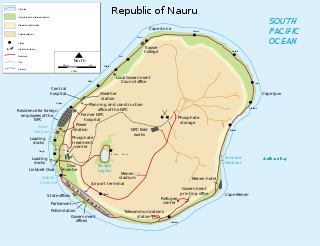
Yaren is a district of the Pacific island country of Nauru. It is the de facto capital of Nauru and is coextensive with Yaren Constituency. It is also the fourth-least-populated capital in the world.

Aiwo is a district in the Pacific country of Nauru. Jarrit Morpak is the city's mayor, elected in 2008. It belongs to Aiwo Constituency.

Anibare is a district in the island nation Nauru, a part of the Anabar Constituency. It is Nauru's largest district in area, and the smallest in population.

Ijuw is a district in the country of Nauru, located in the northeast of the island. The area covers 1.1 km2 and has a population of 276, making Ijuw the least populated district in the country.

Boe is a district in the country of Nauru. It is the only district of Boe Constituency.

Denigomodu is a district in the western part of the island of Nauru. It is the most populous district in Nauru.
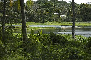
Buada is a district in the Pacific nation of Nauru. It is the only district in Buada Constituency. It has a population of 969 (2021). Several things are special about Buada compared to the coastal areas, it is entirely inland, it has a lagoon, and the soil and vegetation here is more rich.

Ubenide is a constituency of Nauru made up of four districts: Baitsi, Denigomodu, Nibok, and Uaboe. It covers an area of 4.5 km2, making it the second largest constituency by area, and is the most populous constituency with a population of 3,300. It returns four members to the Parliament of Nauru in Yaren, being the only district to return four.
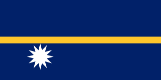
Following the independence of Nauru, the flag of Nauru was raised for the first time. The flag, chosen in a local design competition, was adopted on independence day, 31 January 1968. The design symbolically depicts Nauru's geographical position, with a star just south of the Equator.
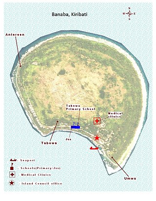
Banaba is an island of Kiribati in the Pacific Ocean. A solitary raised coral island west of the Gilbert Island Chain, it is the westernmost point of Kiribati, lying 185 miles (298 km) east of Nauru, which is also its nearest neighbour. It has an area of six square kilometres (2.3 sq mi), and the highest point on the island is also the highest point in Kiribati, at 81 metres (266 ft) in height. Along with Nauru and Makatea, it is one of the important elevated phosphate-rich islands of the Pacific.

Ewa is a district in the Pacific nation of the Republic of Nauru, located in the north of island.
Buada Lagoon is a landlocked, slightly brackish, freshwater lake of Buada District in the island nation of Nauru. It occupies 3.8 ha with a depth of up to 2m after an extended rainfall.

Nauru is positioned in the Nauru Basin of the Pacific Ocean, on a part of the Pacific Plate that formed at a mid oceanic ridge at 132 Ma. From mid Eocene (35 Ma) to Oligocene times a submarine volcano built up over a hotspot, and formed a seamount composed of basalt. The seamount rises over 4300 m above the ocean floor. This hotspot developed simultaneously with a major Pacific Plate reorganisation.
The following outline is provided as an overview of and topical guide to Nauru:

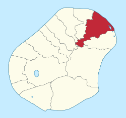
Anabar Constituency is one of the constituencies of Nauru and is made up of three districts: Anabar, Anibare, and Ijuw. It covers an area of 5.1 km², and has a population of 1,240. It returns two members to the Parliament of Nauru in Yaren. It is the largest and easternmost constituency in Nauru.
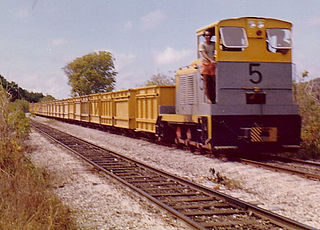
In Nauru, rail transport is used for moving calcium pyrophosphate from the island's interior to the cantilever jetties on the island's western coast. For this purpose, a 3.9 km (2.4 mi) long, 610 mm gauge was built by the Pacific Phosphate Company in 1907. The line passes through the districts of Aiwo, Buada, Denigomodu, Nibok, Uaboe and Anibare.