Anacapa State Marine Reserve

Last updated

Anacapa State Marine Reserve
Map of Channel Islands National Marine Sanctuary, which overlap Channel Island National Park and includes Anacapa State Marine Reserve.jpg
Map of Channel Islands National Marine Sanctuary, which overlaps Channel Islands National Park and includes Anacapa State Marine Reserve
Californian Channel Islands map en.png
Red pog.svg
USA California Southern location map.svg
Red pog.svg
Location Ventura County, California, United States
Coordinates 34°02′N119°23′W / 34.033°N 119.383°W / 34.033; -119.383
Length3.1 miles (5.0 km)
Area11.55 square miles (29.9 km2)
Elevation0–709 feet (0–216 m) below sea level
Established2003
Governing body California Department of Fish and Wildlife

The Anacapa State Marine Reserve (SMR) is a protected marine reserve located off the coast of Southern California, encompassing the area of water immediately north of Anacapa Island. Established to safeguard the marine ecosystems and biodiversity of the region, the reserve is one of the thirteen Marine Protected Areas (MPAs) of the larger Channel Islands National Park network. [1]

Contents

Anacapa State Marine Reserve covers an area of 11.55 square miles (29.9 km2) and has a shoreline span of 3.1 miles (5.0 km). The reserve protects sandy beaches, extensive rocky shores, surf grass beds, kelp forests, deep offshore sand, and rocky seafloor to depths greater than 700 feet (210 m) below sea level. [1] The reserve includes a Special Closure area of approximately 1 square mile (2.6 km2) to protect seabirds and marine species. [1]

Location

Anacapa State Marine Reserve (SMR) is located in Ventura County, California off the north coast of Anacapa Island, the smallest of the northern islands of the Channel Islands archipelago. Anacapa State Marine Reserve is approximately 11 miles (18 km) from the urbanized coast of Southern California and the closest major city is Ventura. The waters of the Marine Reserve cover the north coast of Anacapa Island from Arch Rock, a coastline natural arch at the extreme east point of East Anacapa, to Tidepools, on the east part of West Anacapa. [2] The reserve is one of the four Marine Protected Areas (MPAs) that are situated on the north side of Anacapa Island. The reserve shares a northern border with the Federal Anacapa Island Marine Reserve (FMR) and a western border with the Anacapa Island State Marine Conservation Area (SMCA) and the Federal Anacapa Island Marine Conservation Area (FMCA).

Anacapa Island and the neighbouring Santa Cruz Island, Santa Rosa Island and Santa Barbara Island are part of the Channel Islands National Park. [3] Anacapa State Marine Reserve is also encompassed in the Channel Islands National Marine Sanctuary, which is an area that protects determined marine ecosystems within the United States waters. [4]

The defined area of the Anacapa State Marine Reserve forms a square with corners at the following GPS coordinates: 34° 04.998′ N. lat., 119° 24.600′ W. long.; 34° 04.998′ N. lat., 119° 21.400′ W. long.; 34° 03.870′ N. lat., 119° 21.400′ W. long.; 34° 03.726′ N. lat., 119° 24.600′ W. long. [5]

Establishment

According to the 2009 George Wright Society Conference, before 2003 the area of Anacapa State Marine Reserve was protected by the Anacapa Ecological Reserve. [6]

In 1998, a proposal regarding the establishment of marine protected areas was submitted by a group of recreational fishermen. A community-based plan, directed by the Channel Islands National Marine Sanctuary and the California Department of Fish and Game, was organised to design a network of MPAs. This group of stakeholders was called the Marine Reserves Working Group (MRWG) [7] and included members of the public, government agencies, fisheries representatives, and conservation groups. With the support of data related to the benefits of the former Anacapa Ecological Reserve, the reserve network was implemented in April 2003. [6] Anacapa Island State Marine Reserve, which incorporated the smaller Anacapa Ecological Reserve, was established as a Marine Protected Areas and re-established as part of the statewide MPA Network in 2012. [6]

Regulations

As part of the United States National System of Marine Protected Areas, Anacapa State Marine Reserve is a designated area primarily established to safeguard and preserve marine life in marine or estuarine waters. California's MPA Network comprises 124 areas with different degrees of protection, along with 14 Special Closures, all aimed at safeguarding the marine ecosystems of the state. California Marine Protected Areas (MPAs) were established to situate them strategically close to each other, forming an interconnected network. [8] This network serves as a means to safeguard the uninterrupted movement of life within marine ecosystems. Each MPA within this network has unique goals and rules. Non-consumptive activities, scientific research, monitoring efforts, and educational endeavours may be authorized within these designated areas. [9]

Recreational and commercial fishing restrictions

Activities such as fishing and collecting are strictly prohibited within Anacapa Island State Marine Reserve, which is regarded as one of the most protected MPAs in the region. [8] A range of specific activities are illegal, except under a scientific collecting license for a national reserve, with commission approval or as a result of explicitly sanctioned fishing:

Vessels are permitted to navigate through Anacapa State Marine Reserve while carrying a catch, and anchoring with a catch is allowed in designated areas.

Public safety activities are permitted within Anacapa State Marine Reserve, including the installation, maintenance, and temporary placement/removal of structures related to safety concerns. [10]

Maritime routes restrictions

Anacapa State Marine Reserve is susceptible to specific marine navigation closures, encompassing an area of approximately one square mile, to minimize the disturbance of seabirds and marine mammals. [1]

Local Fauna

Marine Inhabitants

The primary goal of Anacapa Island State Marine Reserve is to preserve the rich and varied marine ecosystem where the convergence of tropical warm water currents and frigid currents from Alaska creates a unique and abundant environment that serves as feeding and refuge grounds for numerous species. [11] Several species of fish are protected within the kelp forests spanning the MPAs and Special Closure. These include California sheephead, Garibaldi (fish), Bat ray, Moray eel, Horn shark, Leopard shark, kelp bass (Paralabrax clathratus), brightly coloured Nudibranch (sea slugs), and Giant sea bass, among many others. [1]

Giant kelp forest at Anacapa Island Landing Cove, part of Anacapa State Marine Reserve. Sanc0023 - Flickr - NOAA Photo Library.jpg
Giant kelp forest at Anacapa Island Landing Cove, part of Anacapa State Marine Reserve.

The cold and dark ocean depths of the reserve provide the optimal environmental conditions for the growth of corals, sponges and invertebrates. The latter have an important role within the ecosystem of the territory. They have a three-dimensional shape that creates the space where the local marine fauna live, grow, and reproduce. The survival of this marine species is at risk because of several factors related to pollution and human activities. While fishing certain groundfish species, there is a potential risk of the nets coming into contact with corals and sponges, inadvertently causing damage. Additional threats include climate change, the extraction of gas and oil, submarine cables, and debris on the seabed. [12] The Channel Islands National Park and Marine Sanctuary provide habitat for significant breeding populations of pinnipeds. In particular, the Anacapa State Marine Reserve is the natural habitat for a large number of California sea lion and Harbor seal. High populations are supported by the mixture of warm waters from Mexico and cold waters from Alaska that mitigate their habitat and bring a multitude of fish that they feed on. The dense kelp forest also provides food and shelter for these mammals. [1]   [13]

The seafloor of the reserve is a habitat for numerous species of crabs, including the sheep crab (Loxorhynchus grandis). Numerous starfish and invertebrates live among the kelp, coral, and sponges of the reserve.

Birds

Brown Pelicans feeding in the waters of Anacapa Island. Feeding Frenzy (11444775753).jpg
Brown Pelicans feeding in the waters of Anacapa Island.

Onshore, the rocky cliffs are surrounded by a Special Closure, which limits access to protect one of the world’s largest breeding colonies of California Brown Pelican. Brown Pelicans and Brandt's cormorants swarm in the area. Several species of bird that once bred in the zone no longer do so, including the Rhinoceros Auklet and the Cassins Auklet.

Whales

Dolphins by Anacapa State Marine Reserve.
Single Gray Whale surfacing at Anacapa Island Special Closure 20170505 NPRW - Kelping 13.jpg
Single Gray Whale surfacing at Anacapa Island Special Closure

Anacapa SMR includes habitats for a range of cetaceans, including dolphins, porpoises, whales, and orcas. Whales are of major importance both for the natural ecosystem and the tourism economy of the territory. There are 27 different species of whales in the area, including blue whales, humpback whales, gray whales, fin whales, and pilot whales. [14]

Anacapa State Marine Reserve is significant for its location on an important gray whale migration route. Gray whales spend their summers feeding in the nutrient-rich waters of the Arctic, and in September they start migrating south along the coastline to breed and calve in Baja California, Mexico. Between February and April, gray whales return on the northward journey. During this migration, gray whales cross the Santa Barbara Channel (also called the 'migrant corridor') passing through Anacapa State Marine Reserve. [15]

Gray whales are commonly sighted in the reserve from mid-to-late December through to mid-March, while blue and humpback whales are prevalent during the summer. Common dolphins can be observed throughout the entire year. Whale watching can be done both from shore or aboard boats. [16]

Management and Administration

Anacapa State Marine Reserve is one of the recipients of the Marine Life Protection Act, which dictated the necessity of monitoring and research concerning the status of marine fauna, habitat, and ecosystems. An assessment of the State Marine Reserve is required; this allows both the evaluation of the effectiveness of the Marine Protected Area and the making of informed management decisions. [17]

Monitoring

The monitoring program of the MPAs is divided into two ecosystem-based phases: the Baseline Monitoring and the Long-Term Monitoring. Anacapa State Marine Reserve Baseline Monitoring took place from 2007 to 2018. Projects related to the Long-Term Monitoring were subsidized between 2019–2022. [17]

Part of the research studies and monitoring of Anacapa State Marine Reserve is directed by the California Department of Fish and Wildlife, cooperatively with Channel Islands National Park and the Partnership for Interdisciplinary Studies of Coastal Oceans (PISCO). Abalone and sea urchins are the subject of study. The citizen-scientist group Reef Check California participates by offering help in the collection of data regarding rocky reefs, kelp forests, and fin fish. [18]

Monitoring studies carried out by PISCO have shown a rise in the biomass of species in northern Channel Islands MPAs, which include Anacapa State Marine Reserve, in comparison with data from 2003. [18]

Research Studies

A range of research studies have been undertaken at Anacapa State Marine Reserve. From 2019 to 2021 Baited remote underwater video (BRUV) landers were used to measure the impact of fishing on the marine ecosystem. [19]

The environmental DNA metabarcoding biomonitoring tool has been used in Anacapa State Marine Reserve and other MPAs to increase the frequency of monitoring and safety of personnel. [20] By using the eDNA metabarcoding biomonitoring tool, personnel with neither diving experience nor taxonomic training may obtain comparable and possibly more thorough results than Scuba-based surveys. [20]

A proposal to relocate groundfish to Anacapa State Marine Reserve from areas around oil platforms in the East Santa Barbara Channel has been tested using acoustic tagging of rockfish and lingcod. Although 75% of the trans-located fish remained in Anacapa SMR waters, the plan was not been implemented due to high costs and the proportion of lingcod which returned to their original habitat. [21]

Recreational Activities

Anacapa State Marine Reserve provides various sites for different marine-related activities and sports such as sea-kayaking, scuba diving, snorkeling, and swimming. [11]

Scuba diving and snorkeling

Diver holding a spiny lobster in the Anacapa State Marine Reserve's kelp forest. Channel-Islands3-NPS-photo-by-Brett-Seymour-Submerged-Resources-Center-by-permission-1000x563-1.png-2.webp
Diver holding a spiny lobster in the Anacapa State Marine Reserve's kelp forest.

The National Park Service allows boat trips to Anacapa Island. Boats depart from the cities of Ventura, and Oxnard. [11] Numerous local dive companies offer excursions through the kelp forest, sea caves, and coves. Swimmers, snorkelers, and divers can see the variety of species of fish and vegetation of the Marine Reserve. [22] Divers can explore several dive sites at depths ranging from 50–120 feet (15–37 m), with visibility averaging from 30–80 feet (9.1–24.4 m). [23]

Wreck diving

The wreck of a Grumman TBF Avenger is situated within the Anacapa Marine Protected Area. It holds historical significance as a World War II United States Navy torpedo bomber. During a training exercise in the early 1950s, it collided with one of the other four aircraft in the formation, resulting in both planes crashing. The Avenger descended on the east side of Anacapa without any casualties. The other plane crashed on the opposite side of Anacapa, leading to loss of life, and the wreck site remains undiscovered. The wreck site of the Avenger is approximately 120 feet (37 m) deep and 40 feet (12 m) away from the reef. The wreck lies on the sand and retains its aircraft shape despite the passage of years. The wreckage has become a focal point for marine life, attracting various fish species. The wreck offers an opportunity for deep diving, with average visibility ranging from 20–60 feet (6.1–18.3 m). [24]

Located within Anacapa SMR is the Winfield Scott wreck, the remains of a paddle steamer that sank in the Santa Barbara Channel in 1853. [25]

Sea kayaking

Anacapa Island State Marine Reserve is a popular location for sea kayaking, with a shoreline characterised by cliffs, coves and numerous sea caves, including the iconic Arch Rock. Due to potentially strong currents along its shore, kayakers are warned to have moderate experience in ocean kayaking. The lack of an accessible beach for access and egress requires kayakers arriving by boat to lower and raise kayaks by rope from a landing dock. [17]

Wildlife and birdwatching

Bird watching is a recreational activity offered by the State Marine Reserve due to the location of important nesting grounds for a substantial population of western gulls, Cassin's auklets, and Brandt's cormorants. The cliffs represent the sole nesting location for California brown pelicans along the West Coast of the United States and include the world's largest population of Scripps's murrelets. [26]

Educational programs

Educational programs for students are provided by the Channel Islands National Park. During these programs, participants can learn more about marine and terrestrial ecosystems. Students targeted for these programs range from elementary school to high school. [27] During the summer months, "Live Dives" are available, providing visitors with the opportunity to witness live underwater dives and explore the marine environment in real time. Visitors can watch underwater activities within the Marine Protected Area without diving by observing the underwater program directly from the shore. Park rangers descend into the kelp forest with dive masks featuring microphones and carrying cameras to capture the underwater scenery and provide explanations about the marine environment that they are recording. [27]

See also

Related Research Articles

<span class="mw-page-title-main">Channel Islands National Marine Sanctuary</span> Marine sanctuary in the Pacific Coast of Southern California

The Channel Islands National Marine Sanctuary is a sanctuary off the coast of Santa Barbara and Ventura counties in Southern California 350 miles south of San Francisco and 95 miles north of Los Angeles. It was designated in 1980 by the National Oceanic and Atmospheric Administration.

<span class="mw-page-title-main">Asilomar State Marine Reserve</span> Marine protected area in California

Asilomar State Marine Reserve (SMR) is one of four small marine protected areas (MPAs) located near the cities of Monterey and Pacific Grove, at the southern end of Monterey Bay on California’s central coast. The four MPAs together encompass 2.96 square miles (7.7 km2). The SMR protects all marine life within its boundaries. Fishing and take of all living marine resources is prohibited.

<span class="mw-page-title-main">Carmel Bay State Marine Conservation Area</span> Marine protected area in Carmel Bay

Carmel Bay State Marine Conservation Area (SMCA) is a marine protected area in Carmel Bay. Carmel Bay is adjacent to the city of Carmel-by-the-Sea and is near Monterey, on California’s central coast. The marine protected area covers 2.12 square miles. Recreational fishing of finfish and limited commercial taking of kelp is permitted within the SMCA.

Moro Cojo Estuary State Marine Reserve (SMR) is a marine protected area established to protect the wildlife and habitats in Moro Cojo Slough. Moro Cojo Slough is located inland from Monterey Bay on the central coast of California, directly south of the more widely known Elkhorn Slough. The area covers 0.46 square miles (1.2 km2). The SMR protects all marine life within its boundaries. Fishing and take of all living marine resources is prohibited.

<span class="mw-page-title-main">Natural Bridges State Marine Reserve</span> Marine protected area immediately west of Natural Bridges State Beach in Santa Cruz, California

Natural Bridges State Marine Reserve (SMR) is a marine protected area located at the northern edge of Santa Cruz, California, approximately 75 miles (121 km) south of San Francisco. The SMR covers 0.58 square miles (1.5 km2). The SMR protects all marine life within its boundaries. Fishing or other removal of any living marine resource is prohibited.

<span class="mw-page-title-main">Gerstle Cove State Marine Reserve</span> Marine reserve in California

Gerstle Cove State Marine Reserve (SMR) is a marine protected area that lies onshore from Salt Point State Park, within the Salt Point State Marine Conservation Area, in Sonoma County on California’s north central coast. The marine protected area covers 0.1 square miles. Gerstle Cove SMR prohibits the take of all living resources.

<span class="mw-page-title-main">Del Mar Landing State Marine Reserve</span> Marine protected area in California

Del Mar Landing State Marine Reserve (SMR) is a marine protected area that lies onshore, about 2 miles (3 km) south of the town of Gualala and 3.5 miles north of Sea Ranch in Sonoma County on California’s north central coast. The marine protected area covers 0.22 square miles (0.57 km2). Del Mar Landing SMR prohibits injuring, damaging, or taking all living, geological, and cultural marine resources.

<span class="mw-page-title-main">Carmel Pinnacles State Marine Reserve</span> Marine protected area in Carmel Bay

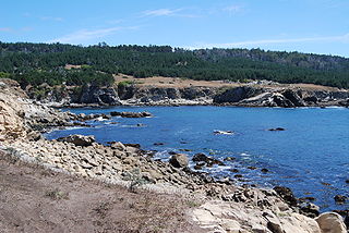
Carmel Pinnacles State Marine Reserve (SMR) is a marine protected area in Carmel Bay including a unique underwater pinnacle formation with adjacent kelp forest, submarine canyon head, and surfgrass. Carmel Bay is adjacent to the city of Carmel-by-the-Sea and is near Monterey, on California's central coast.

<span class="mw-page-title-main">Edward F. Ricketts State Marine Conservation Area</span> Marine protected area in California

Edward F. Ricketts State Marine Conservation Area is one of four small marine protected areas located near the cities of Monterey and Pacific Grove, at the southern end of Monterey Bay on California’s central coast. The four areas together encompass 2.96 square miles (7.7 km2). Within SMCAs fishing and take of all living marine resources is prohibited except the recreational take of finfish by hook-and-line and the commercial take of giant and bull kelp under certain conditions.

<span class="mw-page-title-main">Lovers Point State Marine Reserve</span> Marine protected area

Lovers Point State Marine Reserve (SMR) is one of four small marine protected areas located near the cities of Monterey and Pacific Grove, at the southern end of Monterey Bay on California’s central coast. The four MPAs together encompass 2.96 square miles (7.7 km2). The SMR protects all marine life within its boundaries. Fishing and take of all living marine resources is prohibited.

<span class="mw-page-title-main">Morro Bay State Marine Recreational Management Area and Morro Bay State Marine Reserve</span> Two marine protected areas in California

Morro Bay State Marine Recreational Management Area (SMRMA) and Morro Bay State Marine Reserve (SMR) are two marine protected areas that provide protection for Morro Bay Estuary on California's central coast. The two marine protected areas together encompass 3.31 square miles (8.6 km2). Within the SMRMA, fishing and take of any living marine resources is prohibited except that north of latitude 35° 19.70′ N the recreational take of finfish and aquaculture of oysters, pursuant to a valid state water bottom lease and permit, is permitted. And recreational hunting of waterfowl is allowed unless otherwise restricted by hunting regulations. The SMR protects all marine life within its boundaries. Fishing and take of any living marine resources is prohibited.

<span class="mw-page-title-main">Pacific Grove Marine Gardens State Marine Conservation Area</span> Marine protected area in California

Pacific Grove Marine Gardens State Marine Conservation Area is one of four small marine protected areas located near the cities of Monterey and Pacific Grove, at the southern end of Monterey Bay on California’s central coast. The four MPAs together encompass 2.96 square miles (7.7 km2). Within the SMCA fishing and take of all living marine resources is prohibited except the recreational take of finfish and the commercial take of giant and bull kelp by hand under certain conditions. According to the Frommer's guide, the Marine Gardens area is "renowned for ocean views, flowers, and tide-pool seaweed beds."

<span class="mw-page-title-main">Piedras Blancas State Marine Reserve and Marine Conservation Area</span> Marine protected areas in California

Piedras Blancas State Marine Reserve (SMR) and Piedras Blancas State Marine Conservation Area (SMCA) are two adjoining marine protected areas that lie offshore of San Luis Obispo County on California’s central coast. The combined area of these marine protected areas is 19.68 square miles (51.0 km2). The SMR protects all marine life within its boundaries. Fishing and take of all living marine resources is prohibited. Within the SMCA fishing and take of all living marine resources is prohibited except the commercial and recreational take of salmon and albacore.

<span class="mw-page-title-main">Point Sur State Marine Reserve and Marine Conservation Area</span> Protected area

Point Sur State Marine Reserve (SMR) and Point Sur State Marine Conservation Area (SMCA) are two adjoining marine protected areas that lie offshore of Point Sur, part of the Big Sur area on California's central coast. The combined area of these marine protected areas is 19.68 square miles (51.0 km2). The SMR protects all marine life within its boundaries. Fishing and taking of all living marine resources is prohibited in the SMR. Within the SMCA, fishing and taking of all living marine resources is prohibited except the commercial and recreational take of salmon and albacore.

Portuguese Ledge State Marine Conservation Area (SMCA) is an offshore marine protected area in Monterey Bay. Monterey Bay is on California’s central coast with the city of Monterey at its south end and the city of Santa Cruz at its north end. The SMCA covers 10.9 square miles (28 km2). Within the SMCA fishing and take of all living marine resources is prohibited except the commercial and recreational take of pelagic finfish.

<span class="mw-page-title-main">Soquel Canyon State Marine Conservation Area</span> Marine protected area in Monterey Bay

Soquel Canyon State Marine Conservation Area (SMCA) is an offshore marine protected area in Monterey Bay. Monterey Bay is on California’s central coast with the city of Monterey at its south end and the city of Santa Cruz at its north end. The SMCA covers 23.41 square miles (60.6 km2). Within the SMCA, fishing and taking of any living marine resources is prohibited except the commercial and recreational take of pelagic finfish.

<span class="mw-page-title-main">White Rock (Cambria) State Marine Conservation Area</span> Marine protected area off the coast of Cambria, California

White Rock (Cambria) State Marine Conservation Area (SMCA) is a marine protected area located off the coast of the city of Cambria, California on California’s central coast. The marine protected area covers 2.32 square miles (6.0 km2). Within the SMCA the take of all living marine resources is prohibited except the commercial take of giant kelp and bull kelp under certain conditions.

San Diego-Scripps Coastal Marine Conservation Area (SMCA) and Matlahuayl State Marine Reserve (SMR) are adjoining marine protected areas that extend offshore from La Jolla in San Diego County on California’s south coast. The two marine protected areas cover 2.51 square miles. San Diego-Scripps Coastal SMCA prohibits the take of all living marine resources except that coastal pelagic species, not including market squid, may be taken recreationally by hook and line. Matlahuayl SMR prohibits the take of all living marine resources.

<span class="mw-page-title-main">Laguna Beach State Marine Reserve</span> Marine protected area in California

Laguna Beach State Marine Reserve (SMR) and Laguna Beach State Marine Conservation Area (SMCA) are two adjoining marine protected areas that extend offshore of Laguna Beach in Orange County on California’s south coast. The SMR covers 6.27 square miles, and the SMCA covers an additional 3.44 square miles. These two MPAs are part of a four-MPA complex on the coast of southern Orange County. Each protects marine life by prohibiting or limiting the removal of marine wildlife from within its borders.

Long Point State Marine Reserve (SMR) is a marine protected area that includes offshore, island marine habitat off California’s south coast. The SMR covers 1.66 square miles. The SMR protect marine life by prohibiting the removal of marine wildlife from within its borders. Long Point SMR prohibits take of all living marine resources.

References

  1. 1 2 3 4 5 6 The State of California (2020). "Anacapa Island State Marine Reserve". wildlife.ca.gov. California, USA: The Government. Retrieved November 21, 2023.
  2. U.S. Department of Interior. "Channel Island" (PDF). Retrieved October 4, 2023.
  3. "Channel Islands National Park (U.S.)". National Park Service(.gov). National Park Service U.S. Department of the Interior. Retrieved December 17, 2023.
  4. "What is a national marine sanctuary? – National Ocean Service". National Oceanic and Atmospheric Administration (.gov). Department of Commerce National Oceanic and Atmospheric Administration (NOAA) National Ocean Service. Retrieved December 17, 2023.
  5. "Anacapa Island SMR". California Marine Protected Areas. Retrieved November 28, 2023.
  6. 1 2 3 Daniel V. Richards (2009). "Foundations of Marine Reserves in the California Channel Islands" (PDF). georgewright.org. Channel Islands National Park: George Wright Society Conference. Retrieved November 21, 2023.
  7. "Working Groups and Subcommittees". Channel Island National Marine Sanctuary. National Oceanic and Atmospheric Administration. Retrieved December 11, 2023.
  8. 1 2 The State of California (2020). "California Marine Protected Areas". wildlife.ca.gov. California, USA: The Government. Retrieved November 21, 2023.
  9. "Anacapa Island State Marine Reserve". CA.Gov. California Department of Fish & Wildlife. Retrieved December 7, 2023.
  10. "California Code of Regulations – Marine Protected Areas (MPAs), Marine Managed Areas (MMAs), and Special Closures". Westlaw. Thomson Reuters. Retrieved December 7, 2023.
  11. 1 2 3 California Department of Fish and Wildlife (2023). "Anacapa Island State Marine Reserve". State of California. Retrieved November 21, 2023.
  12. "Channel Islands National Marine Sanctuary". Channel Islands National Marine Sanctuary(.gov). Office of National Marine Sanctuaries. Retrieved November 28, 2023.
  13. "Seal and Sea Lion Viewing". National Park Service. National Park California. Retrieved December 9, 2023.
  14. National Ocean Service. "Wildlife Health Channel Islands – National Marine Sanctuaries". National Oceanic and Atmospheric Administration (.gov). Retrieved December 1, 2023.
  15. Jean-Micheal, Cousteau. "Gray Whale Migration Route". Jean-Micheal Cousteau's Ocean Futures Society. Ocean Futures Society. Retrieved November 28, 2023.
  16. "Whale Watching". Channel Islands. National Park California. Retrieved December 1, 2023.
  17. 1 2 3 "About the MPA Monitoring Program". California Department of Fish and Wildlife. State of California. Retrieved December 1, 2023.
  18. 1 2 Ocean Science Trust; California Ocean Protection Council; SeaGrant California; California Department of Fish and Wildlife; OceanSPACE (December 2018). "Monitoring California Channel Islands" (PDF). Ocean Science Trust. Retrieved November 30, 2023.
  19. Jainese, Conner J. (2023). Marine Protected Area Effects on Mesophotic Rocky Reef Fish Communities Using Baited Remote Underwater Video (PhD thesis). University of California.
  20. 1 2 Zachary Gold; Joshua Sprague; David J. Kushner; Erick Zerecero Marin; Paul H. Barber (February 24, 2021). "eDNA metabarcoding as a biomonitoring tool for marine protected areas". Researchgate. Retrieved December 3, 2023.
  21. Kim M., Anthony; Milton S., Love; Christopher G., Lowe. "Translocation, homing behavior and habitat use of groundfishes associated with oil platforms in the East Santa Barbara Channel, California" (PDF). Bulletin of the Southern California Academy of Sciences. University of California, Santa Barbara. Retrieved December 12, 2023.
  22. "Diving and Snorkeling". Channel Islands. National Park California. Retrieved December 1, 2023.
  23. "recreation". Anacapa Island state Marine Reserve. California Department of Fish and Wildlife.
  24. "Anacapa MPA". Santa Barbara Channelkeeper. Retrieved December 1, 2023.
  25. "Shipwrecks: The Winfield Scott". National Park Services. Channel Islands National Park California. Retrieved December 7, 2023.
  26. "Bird Watching". Channel Islands. National Park California. December 1, 2023. Retrieved December 1, 2023.
  27. 1 2 "Program Description for Channel Island Live Distance Learning". National Park Service. ww.nps.gov.