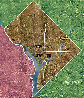
Washington, D.C., formally the District of Columbia (D.C.), also known as just Washington, is the capital city of the United States. It is located on the east bank of the Potomac River which forms its southwestern and southern border with the U.S. state of Virginia, and shares a land border with the U.S. state of Maryland on its remaining sides. The city was named for George Washington, the first president of the United States and a Founding Father, and the federal district is named after Columbia, a female personification of the nation. As the seat of the U.S. federal government and several international organizations, the city is an important world political capital. It is one of the most visited cities in the U.S., seeing over 20 million visitors in 2016.

The Anacostia Community Museum is a community museum in the Anacostia neighborhood of Washington, D.C., in the United States. It is one of twenty museums under the umbrella of the Smithsonian Institution and was the first federally funded community museum in the United States. The museum, founded in 1967, was created with the intention to bring aspects of the Smithsonian museums, located on the National Mall, to the Anacostia neighborhood, with the hope that community members from the neighborhood would visit the main Smithsonian museums. It became federally funded in 1970 and focuses on the community in and around Anacostia in its exhibitions. This museum also houses a library.

Anacostia is a historic neighborhood in Washington, D.C. Its downtown is located at the intersection of Good Hope Road and Martin Luther King Jr. Avenue. It is located east of the Anacostia River, after which the neighborhood is named. Like the other quadrants of Washington, D.C., Southeast encompasses many named neighborhoods, of which Anacostia is the most well known. Anacostia includes all of the Anacostia Historic District that was listed on the National Register of Historic Places in 1978. Often the name Anacostia is incorrectly used to refer to the entire portion of the city that is southeast of the Anacostia River. The Anacostia Business Improvement District is responsible for the development of the area.

Southwest is the southwestern quadrant of Washington, D.C., the capital of the United States, and is located south of the National Mall and west of South Capitol Street. It is the smallest quadrant of the city, and contains a small number of named neighborhoods and districts, including Bellevue, Southwest Federal Center, the Southwest Waterfront, Buzzard Point, and the military installation known as Joint Base Anacostia–Bolling.
Benning Road is a major traveled street in Washington, D.C., and Prince George's County, Maryland.

Congress Heights is a residential neighborhood in Southeast Washington, D.C., in the United States. The irregularly shaped neighborhood is bounded by the St. Elizabeths Hospital campus, Lebaum Street SE, 4th Street SE, and Newcomb Street SE on the northeast; Shepard Parkway and South Capitol Street on the west; Atlantic Street SE and 1st Street SE on the south; Oxon Run Parkway on the southeast; and Wheeler Street SE and Alabama Avenue SE on the east. Commercial development is heavy along Martin Luther King, Jr. Avenue and Malcolm X Avenue.

The history of Washington, D.C., is tied to its role as the capital of the United States. Originally inhabited by an Algonquian-speaking people known as the Nacotchtank, the site of the District of Columbia along the Potomac River was first selected by President George Washington. The city came under attack during the War of 1812 in an episode known as the Burning of Washington. Upon the government's return to the capital, it had to manage the reconstruction of numerous public buildings, including the White House and the United States Capitol. The McMillan Plan of 1901 helped restore and beautify the downtown core area, including establishing the National Mall, along with numerous monuments and museums.

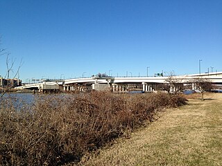
The 11th Street Bridges are a complex of three bridges across the Anacostia River in Washington, D.C., United States. The bridges convey Interstate 695 across the Anacostia to its southern terminus at Interstate 295 and DC 295. The bridges also connect the neighborhood of Anacostia with the rest of the city of Washington.

Barney Circle is a small residential neighborhood located between the west bank of the Anacostia River and the eastern edge of Capitol Hill in southeast Washington, D.C., in the United States. The neighborhood is characterized by its sense of community, activism, walkability, and historic feel. The neighborhood's name derives from the eponymous former traffic circle Pennsylvania Avenue SE just before it crosses the John Philip Sousa Bridge over the Anacostia. The traffic circle is named for Commodore Joshua Barney, Commander of the Chesapeake Bay Flotilla in the War of 1812.

The Southwest Waterfront is a mostly residential neighborhood in Southwest Washington, D.C. The Southwest quadrant is the smallest of Washington's four quadrants, and the Southwest Waterfront is one of only two residential neighborhoods in the quadrant; the other is Bellevue, which, being east of the Anacostia River, is frequently, if mistakenly, regarded as being in Southeast. For that reason, many residents of Southwest Waterfront will refer to themselves as living in "Southwest."

Bellevue is a residential neighborhood in far Southeast and Southwest in Washington, D.C., United States. It is bounded by South Capitol Street, one block of Atlantic Street SE, and 1st Streets SE and SW to the north and east; Joliet Street SW and Oxon Run Parkway to the south; Martin Luther King Jr. Avenue SE, Shepherd Parkway, 2nd Street SW, and Xenia Street SW to the west. Bellevue was created from some of the earliest land patents in Maryland, and draws its name from a 1795 mansion built in the area. Subdivisions began in the 1870s, but extensive residential building did not occur until the early 1940s. Bellevue is adjacent to a number of federal and city agency buildings.

Fairlawn is a working class and middle class residential neighborhood in southeast Washington, D.C., United States. It is bounded by Interstate 295, Pennsylvania Avenue SE, Minnesota Avenue SE, Naylor Road SE, and Good Hope Road SE.

Washington Highlands is a residential neighborhood in Southeast Washington, D.C., in the United States. It lies within Ward 8.

Greenway is a residential neighborhood in Southeast Washington, D.C., in the United States. The neighborhood is bounded by East Capitol Street to the north, Pennsylvania Avenue SE to the south, Interstate 295 to the west, and Minnesota Avenue to the east.

Kenilworth is a residential neighborhood in Northeast Washington, D.C., located on the eastern bank of the Anacostia River and just inside the D.C.-Maryland border. A large public housing complex, Kenilworth Courts, dominates the area. The neighborhood is famous for the Kenilworth Park and Aquatic Gardens, a national park whose centerpiece is a series of ponds carved out of Anacostia River marshland. Visitors come especially during June and July to see the beautiful blooming water lilies and lotus flowers. In 1895 the name “Kenilworth” was first applied to the area by white real estate developer Allen Mallery, who named this neighborhood after Kenilworth Castle in England, the ruins of which can still be seen today in Warwickshire. Kenilworth Park, which includes the Kenilworth-Parkside Recreation Center, also carries the neighborhood name, though most of the park's area is actually located adjacent to the modern neighborhoods of Parkside and Eastland Gardens.
The District of Columbia Public Library (DCPL) is the public library system for the District of Columbia, in the United States. The system includes 26 individual libraries including Martin Luther King Jr. Memorial Library.

The DC Streetcar is a surface streetcar network in Washington, D.C. As of 2017, it consists of only one line: a 2.2-mile (3.5 km) segment running in mixed traffic along H Street and Benning Road in the city's Northeast quadrant.
The Mount Pleasant Library at 1600 Lamont Street, NW in Washington, DC is a branch of the District of Columbia Public Library System that opened in May 1925, and is the third oldest public library building still in use in Washington.

Francis A. Gregory Neighborhood Library is part of the District of Columbia Public Library (DCPL) System. It was originally opened to the public in 1961. A new building on the same site, designed by award-winning architect David Adjaye opened on June 19, 2012.

The Takoma Park Neighborhood Library is part of the District of Columbia Public Library (DCPL) System. It was opened to the public in 1911.


