Anacostia and Potomac River Railroad

Last updated

Anacostia and Potomac River Railroad
Overview
Locale Washington, D.C., U.S.
Transit type Horsecar (1875-1900)
Streetcar (1900-1912)
Operation
Began operation1875
Ended operationAugust 31, 1912 (1912-08-31)
Technical
Track gauge 4 ft 8+12 in (1,435 mm) standard gauge

The Anacostia and Potomac River Railroad Company was the fourth streetcar company to operate in Washington, D.C., and the first to cross the Anacostia River. [1] It was chartered in 1870, authorized by Congress in 1875 and built later that year. The line ran from the Arsenal (now Fort McNair) to Union Town (now Historic Anacostia). It expanded, adding lines to Congressional Cemetery, Central Market and to the Government Hospital for the Insane; and in the late 1890s it purchased two other companies and expanded their lines. It was reluctant to change its operations, but in 1900 it relented to pressure and became the last company to switch from horsecars to electric streetcars. It was one of the few companies not to be swept up by the two major streetcar companies at the turn of the 20th century, but it could not hold out forever and on August 31, 1912, it was purchased by the Washington Railway and Electric Company and ceased to operate as a unique entity.

Contents

Origins

Map of the Washington, D.C. Streetcar System at the end of the Horse Car era in 1888 1888 WDC Streetcar Map.JPG
Map of the Washington, D.C. Streetcar System at the end of the Horse Car era in 1888

The Anacostia and Potomac River Railroad was chartered on May 5, 1870, given approval by Congress on February 18, 1875, [2] and constructed across the Anacostia River later that year. The streetcars traveled from the Arsenal, along M Street SW/SE and 11th Street SE, and crossed the Navy Yard Bridge to Uniontown (now Historic Anacostia). The route then led down Nichols Avenue SE (now Martin Luther King Avenue) to V Street SE where a car barn and stables were maintained by the company. [3]

Expansion

On August 1, 1888, the railroad was permitted to expand from the Navy Yard to Congressional Cemetery along 11th Street SE and G Street SE, and past Garfield Park to the Center Market (now the National Archives) in downtown. It completed the expansion later that year. At the same time it was permitted to expand along Nichols Avenue past the Government Hospital for the Insane (now St. Elizabeths Hospital) to the District boundary, though it only made it as far as Alabama Avenue SE. [2]

The next year, on June 24, 1898, the Anacostia and Potomac River continued its expansion by purchasing the Belt Railway and extended its 11 Street line from F street NW to Florida Avenue NW. In 1899, it purchased the Capital Railway. [4] [5]

The company came into a dispute with the Washington, Alexandria and Mount Vernon Railway over their shared use of track on Fourteenth Street. Following litigation that settled in April 1900, the two companies became joint owners of the track in the dispute with the Anacostia and Potomac to pay $18,000 for its share and to provide a 550  V power supply for the WA&MV streetcars to operate there. [6]

Switch to electric power

The company finally switched from horses to electric in April 1900. It was the last horse-drawn streetcar to run in the District. [7]

The end of the line

One of several extant manhole covers from the Anacostia and Potomac River Railroad Company A&PRR manhole cover.jpg
One of several extant manhole covers from the Anacostia and Potomac River Railroad Company

On June 5, 1899, the Anacostia and Potomac, along with eleven other companies in the area, became subsidiaries of the Washington Traction and Electric Company, which was incorporated on that date as a holding company to unify streetcar operations in the area. [8] The holding company later merged with the Capital Traction Company in 1933. The Anacostia and Potomac River, though initially involved, avoided being wholly purchased during this period. Nonetheless, on August 31, 1912, the Washington Railway purchased the controlling stock of the Anacostia and Potomac River, and it ceased to run as a separate company. [4]

In 1938, two lawsuits were brought against the Washington Railway by the bondholders of the Anacostia & Potomac to pay nearly $4,000,000 in bonds from the former company. [9]

Related Research Articles

<span class="mw-page-title-main">Pepco</span> American energy company

The Potomac Electric Power Company (PEPCO) is an American utility company that supplies electric power to the city of Washington, D.C., and to surrounding communities in Maryland. It is owned by Exelon.

<span class="mw-page-title-main">Congress Heights</span> Neighborhood in Ward 8, United States

Congress Heights is a residential neighborhood in Southeast Washington, D.C., in the United States. The irregularly shaped neighborhood is bounded by the St. Elizabeths Hospital campus, Lebaum Street SE, 4th Street SE, and Newcomb Street SE on the northeast; Shepard Parkway and South Capitol Street on the west; Atlantic Street SE and 1st Street SE on the south; Oxon Run Parkway on the southeast; and Wheeler Street SE and Alabama Avenue SE on the east. Commercial development is heavy along Martin Luther King, Jr. Avenue and Malcolm X Avenue.

<span class="mw-page-title-main">Streetcars in Washington, D.C.</span> Streetcars that existed in Washington until 1962

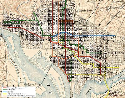
Streetcars in Washington, D.C. transported people across the city and region from 1862 until 1962.

<span class="mw-page-title-main">South Capitol Street</span>

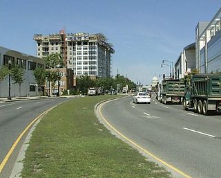
South Capitol Street is a major street dividing the southeast and southwest quadrants of Washington, D.C., in the United States. It runs south from the United States Capitol to the D.C.–Maryland line, intersecting with Southern Avenue. After it enters Maryland, the street becomes Indian Head Highway at the Eastover Shopping Center, a terminal or transfer point of many bus routes.

<span class="mw-page-title-main">Northern Virginia trolleys</span> Network of electronic passenger rails

The Northern Virginia trolleys were the network of electric passenger rails that moved people around the Northern Virginia suburbs of Washington, D.C., from 1892 to 1941. They consisted of six lines operated by as many as three separate companies connecting Rosslyn, Great Falls, Bluemont, Mount Vernon, Fairfax City, Camp Humphries and Nauck across the Potomac River to the District of Columbia.

<span class="mw-page-title-main">Rock Creek Railway</span>

The Rock Creek Railway was one of the first electric streetcar companies in Washington, D.C., and the first to extend into Maryland.

<span class="mw-page-title-main">Barney Circle</span> Neighborhood in the United States

Barney Circle is a small residential neighborhood located between the west bank of the Anacostia River and the eastern edge of Capitol Hill in southeast Washington, D.C., in the United States. The neighborhood is characterized by its sense of community, activism, walkability, and historic feel. The neighborhood's name derives from the eponymous former traffic circle Pennsylvania Avenue SE just before it crosses the John Philip Sousa Bridge over the Anacostia. The traffic circle is named for Commodore Joshua Barney, Commander of the Chesapeake Bay Flotilla in the War of 1812.

<span class="mw-page-title-main">Streetcars in Washington, D.C., and Maryland</span>

Streetcars and interurbans operated in the Maryland suburbs of Washington, D.C., between 1890 and 1962. Lines in Maryland were established as separate legal entities, but eventually they were all owned or leased by DC Transit. Unlike the Virginia lines, the Washington and Maryland lines were scheduled as a single system. Most of the streetcar lines were built with grand plans in mind, but none succeeded financially. A combination of the rise of the automobile, various economic downturns and bustitution eventually spelled the end of streetcars in southern Maryland.

<span class="mw-page-title-main">Fairlawn (Washington, D.C.)</span> Neighborhood in Ward 8, United States

Fairlawn is a working class and middle class residential neighborhood in southeast Washington, D.C., United States. It is bounded by Interstate 295, Pennsylvania Avenue SE, Minnesota Avenue SE, Naylor Road SE, and Good Hope Road SE.

<span class="mw-page-title-main">Greenway (Washington, D.C.)</span> Neighborhood in Ward 7, United States

Greenway is a residential neighborhood in Southeast Washington, D.C., in the United States. The neighborhood is bounded by East Capitol Street to the north, Pennsylvania Avenue SE to the south, Interstate 295 to the west, and Minnesota Avenue to the east.

The Capital Traction Company was the smaller of the two major street railway companies in Washington, D.C., in the early 20th century.

<span class="mw-page-title-main">Washington and Georgetown Railroad</span> American streetcar company

The Washington and Georgetown Railroad Company was the first streetcar company to operate in Washington, D.C., United States. It was incorporated and started operations in 1862, using horse-drawn cars on tracks between Georgetown and the Navy Yard. Two additional lines ran on 7th Street NW/SW and 14th Street NW. In 1890, it switched to cable cars. On September 21, 1895, the company was purchased by the Rock Creek Railway and the two formed the Capital Traction Company.

<span class="mw-page-title-main">Pennsylvania Avenue Line (Washington, D.C.)</span> Daily Metrobus route in Washington, D.C., United States

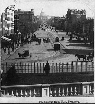
The Pennsylvania Avenue Line, designated Routes 32 and 36, is a daily Metrobus route in Washington, D.C., Operating between the Southern Avenue station or Naylor Road station of the Green Line of the Washington Metro and Potomac Park. Until the 1960s, it was a streetcar line, opened in 1862 by the Washington and Georgetown Railroad as the first line in the city.

<span class="mw-page-title-main">Washington Railway and Electric Company</span>

The Washington Railway and Electric Company (WRECo) was the larger of the two major streetcar companies in Washington, D.C., and its Maryland suburbs in the early decades of the 20th century.

<span class="mw-page-title-main">Metropolitan Railroad</span>

The Metropolitan Railroad was the second streetcar company to operate in Washington, D.C., the capital city of the United States. It was incorporated and started operations in 1864, running from the Capitol to the War Department and along H Street NW in downtown. It added lines on 9th Street NW, on 4th Street SW/SE, along Connecticut Avenue to Dupont Circle, to Georgetown, to Mount Pleasant and north along Georgia Avenue. In the late 19th century, it was purchased by the Washington Traction and Electric Company and on February 4, 1902, became a part of the Washington Railway and Electric Company.

<span class="mw-page-title-main">Columbia Railway</span>

The Columbia Railway was the third streetcar company to operate in Washington, D.C. It was incorporated and started operations in 1870, running from the Treasury Building along H Street NW/NE to the city boundary at 15th Street NE. It switched to cable power in 1895 and then electric power in 1899. The company extended to Seat Pleasant, Maryland, and Kenilworth in 1898. In the late 19th century, it was purchased by the Washington Traction and Electric Company and on February 4, 1902, became a part of the Washington Railway and Electric Company.

<span class="mw-page-title-main">Capitol, North O Street and South Washington Railway</span>

The Capitol, North O Street and South Washington Railway was a street railway company in Washington, D.C., from 1875 to 1898. It was the sixth and final company to start during the horse car era. It operated on a loop, or "belt," around downtown and the National Mall. For that reason, and because of its long name, it was known colloquially as the Belt Railway. It changed its name to the Belt Railway in 1893. It expanded north and south on 11th street west to the boundaries of the city. In 1896 it attempted to use compressed air motors instead of electricity, a decision that sent them into receivership. In 1898, the company was purchased by the Anacostia and Potomac River Railroad and the company ceased to exist.

<span class="mw-page-title-main">Pennsylvania Avenue Bridge (1890)</span> Bridge in United States of America

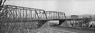
The Pennsylvania Avenue Bridge was a crossing of the Anacostia River in Washington, DC at the site of the present John Philip Sousa Bridge. It was constructed in 1890 and demolished around 1939.

A trio of streetcar companies provided service along a single 10-mile line from the Washington, D.C., neighborhood of Georgetown northward and ultimately to Rockville, Maryland, in the early decades of the 20th century.

References

  1. Trieschmann et al. (2006), p. 21.
  2. 1 2 Laws Relating to Street-railway Franchises in the District of Columbia. Washington, D.C.: United States, District of Columbia Board of Commissioners. 1896 via Google Books.
  3. Eckmann, Alan; et al. (April 2004). "Anacostia Corridor Demonstration Project - Environmental Assessment" (PDF). District of Columbia Department of Transportation. Archived from the original (PDF) on June 19, 2006. Retrieved January 24, 2007.
  4. 1 2 Tindall, Dr. William (1918). Records of the Columbia Historical Society, Washington, D.C.: Beginning of Street Railways in the National Capital. Charlottesville, VA: Columbia Historical Society. pp. 24–118 via Google Books.
  5. "District Railroads". Evening Star. Washington, D.C. February 24, 1899. p. 1 via Newspapers.com. Open Access logo PLoS transparent.svg
  6. "Their Differences Settled". The Evening Times. Washington, D.C. April 26, 1900. p. 2 via Newspapers.com. Open Access logo PLoS transparent.svg
  7. Tindall, William (1914). Standard History of the City of Washington from a Study of the Original Sources. Knoxville, TN: H.W. Crew & Co. pp.  414–429 via Archive.org. Brightwood Railway Company.
  8. Trieschmann et al. (2006), pp. 60–61.
  9. "$4,000,000 Asked in Railway Suits". Evening Star. Washington, D.C. October 4, 1938. p. 35 via Newspapers.com. Open Access logo PLoS transparent.svg