Anthropogenic biome

Last updated
Anthropogenic biomes (v1 from Ellis & Ramankutty (2008)) Anthrome map v1 600.png
Anthropogenic biomes (v1 from Ellis & Ramankutty (2008))

Anthropogenic biomes, also known as anthromes, human biomes or intensive land-use biome, describe the terrestrial biosphere (biomes) in its contemporary, human-altered form using global ecosystem units defined by global patterns of sustained direct human interaction with ecosystems. Anthromes are generally composed of heterogeneous mosaics of different land uses and land covers, including significant areas of fallow or regenerating habitats. [1] [2]

Contents

Origin and evolution of the concept

Anthromes were first named and mapped by Erle Ellis and Navin Ramankutty in their 2008 paper, "Putting People in the Map: Anthropogenic Biomes of the World". [3] Anthrome maps now appear in numerous textbooks. [4] and in the National Geographic World Atlas. [5] The most recent version of anthrome maps were published in 2021. [6]

In a recent global ecosystem classification, anthropogenic biomes have been incorporated into several distinct functional biomes in the terrestrial and freshwater realms, and additional units have been described for the freshwater, marine, subterranean and transitional realms to create a more comprehensive description of all ecosystems created and maintained by human activities. The intensive land-use biome comprises five distinct terrestrial ecosystem functional groups: pastures, crops, plantations, urban and semi-natural ecosystem functional group. The artificial wetlands biome in the freshwater realm includes large reservoirs and other constructed wetlands, rice paddies, aquafarms and networks of canals and ditches. The anthropogenic marine biome in the marine realm includes submerged artificial structures and marine aquafarms. The anthropogenic subterranean voids biome includes industrial excavations or artificial cave-like systems. There are two additional biomes in transitions between realms: the anthropogenic shoreline biome includes artificial shorelines; the anthropogenic subterranean freshwaters biome includes water pipes, subterranean canals and flooded mines. [7]

Anthropogenic transformation of the Biosphere

For more than a century, the biosphere has been described in terms of global ecosystem units called biomes, which are vegetation types like tropical rainforests and grasslands that are identified in relation to global climate patterns. Considering that human populations and their use of land have fundamentally altered global patterns of ecosystem form, process, and biodiversity, anthropogenic biomes provide a framework for integrating human systems with the biosphere in the Anthropocene.

Before 1700

Humans have been altering ecosystems since we have evolved. Evidence suggests that our ancestors were burning land to clear it at one million years ago. 600,000 years ago, humans were using spears to kill horses and other large animals in Great Britain and China. For the past tens of thousands of years, humans have greatly changed the plant and animal life around the globe, from what type of wildlife and plant life dominated to what type of ecosystems dominate. [8] Examples include Native Americans; they altered the forest, burnt land to clear it, settled in cities, disrupting forests and other ecosystems, and built monuments that required moving large amounts of earth, such as the Cahokia Monuments. [8] More examples are the civilizations of the ancient world; they mined large amounts of material, made roads, and especially for the Romans, when mining lead, released large amounts of mercury and lead into the air. A recent study showed that nearly three quarters of Earth's land was already inhabited and reshaped by human societies as long as 12,000 years ago. [6]

Agriculture (1700–present)

Humans have been altering ecosystems since before agriculture first developed, and as the human population has grown and become more technologically advanced over time, the land use for agricultural purposes has increased significantly. The anthropogenic biome in the 1700s, before the industrial revolution, was made up of mostly wild, untouched land, with no human settlement disturbing the natural state. [9] In this time period, most of the Earth's ice-free land consisted of wildlands and natural anthromes, and it wasn't until after the industrial revolution in the 19th century that land use for agriculture and human settlements started to increase. [10] With technology advancing and manufacturing processes becoming more efficient, the human population was beginning to thrive, and was subsequently requiring and using more natural resources. By the year 2000, over half of the Earth's ice free land was transformed into rangelands, croplands, villages and dense settlements, which left less than half of the Earth's land untouched. [10] Anthropogenic changes between 1700 and 1800 were far smaller than those of the following centuries, and as such the rate of change has increased over time. As a result, the 20th century had the fastest rate of anthropogenic ecosystem transformation of the past 300 years. [10]

Land distribution

As the human population steadily increased in numbers throughout history, the use of natural resources and land began to increase, and the distribution of land used for various agricultural and settlement purposes began to change. The use of land around the world was transformed from its natural state to land used for agriculture, settlements and pastures to sustain the population and its growing needs. The distribution of land among anthromes underwent a shift away from natural anthromes and wildlands towards human-altered anthromes we are familiar with today. Now, the most populated anthromes (dense settlements and villages) account for only a small fraction of the global ice-free land. [10] From the year 1700-2000, lands used for agriculture and urban settlements increased significantly, however the area occupied by rangelands increased even more rapidly, so that it became the dominant anthrome in the 20th century. [10] As a result, the biggest global land-use change as a result of the industrial revolution, was the expansion of pastures. [10]

Human population

Following the industrial revolution, the human population experienced a rapid increase. The human population density in certain anthromes began to change, shifting away from rural environments to urban settlements, where the population density was much higher. [9] These changes in population density between areas shifted global patterns of anthrome emergence, and also had wide-spread effects on various ecosystems. [9] Half of the Earth's population now lives in cities, and most people reside in urban anthromes, with some populations dwelling in smaller cities and towns. [10] Currently, human populations are expected to grow until at least midcentury, [11] and the transformation of the Earth's anthromes are expected to follow this growth.

Current state of the anthropogenic biosphere

The present state of the terrestrial biosphere is predominantly anthropogenic. [9] More than half of the terrestrial biosphere remains unused directly for agriculture or urban settlements, and of these unused lands still remaining, less than half are wildlands. Most of Earth's unused lands are now within the agricultural and settled landscapes of semi-natural, rangeland, cropland and village anthromes. [10]

Anthromes map for 2017 with timeline of anthrome changes from 10,000 BCE to 2017 CE. From Ellis et al. (2021) Anthromes map and timeline (10,000 BCE to 2017 CE).png
Anthromes map for 2017 with timeline of anthrome changes from 10,000 BCE to 2017 CE. From Ellis et al. (2021)

Major anthromes

Anthromes include dense settlements (urban and mixed settlements), villages, croplands, rangelands and semi-natural lands and have been mapped globally using two different classification systems, viewable on Google Maps and Google Earth. [12] There are currently 18 anthropogenic biomes, the most prominent of which are listed below. [11]

Dense settlements

Dense settlements are the second most densely populated regions in the world. [12] They are defined as areas with a high population density, though the density can be variable. [12] The population density, however, never falls below 100 persons/km, even in the non-urban parts of the dense settlements, and it has been suggested that these areas consist of both the edges of major cities in underdeveloped nations, and the long standing small towns throughout western Europe and Asia. [12] Most often we think of dense settlements as cities, but dense settlements can also be suburbs, towns and rural settlements with high but fragmented populations. [13]

Villages

Villages are densely populated agricultural landscapes, many of which have been inhabited and intensively used for centuries to millennia.

Croplands

Croplands are another major anthrome throughout the world. Croplands include most of the cultivated lands of the world, and also about a quarter of global tree cover. [12] Croplands which are locally irrigated have the highest human population density, [12] likely due to the fact that it provides crops with a constant supply on water. This makes harvest time and crop survival more predictable. Croplands that are sustained mainly from the local rainfall are the most extensive of the populated anthromes, [12] with annual precipitation near 1000 mm in certain areas of the globe. In these areas, there is sufficient water supplied by the climate to support all aspects of life without hardly any irrigation. [12] However, in dryer areas, this method of agriculture would not be as productive.

Rangelands

Rangelands are a very broad anthropogenic biome group that has been described according to three levels of population density: residential, populated and remote. The Residential rangeland anthrome has two key features: its population density is never below 10 persons per square kilometre, and a substantial portion of its area is used for pasture. [12] Pastures in rangelands are the most dominant land cover. Bare earth is significant in this anthrome, covering nearly one third of the land for every one square kilometer. [12] Rangeland anthromes are less altered than croplands, but their alteration tends to increase with population. [9] Domesticated grazing livestock are typically adapted to grasslands and savannas, so the alteration of these biomes tends to be less noticeable. [9]

Cultured lands

Cultured anthromes are landscapes shaped by low levels of intensive land use and substantial to very low density populations. The Cultured anthrome classification was introduced in 2021 [2] to replace analogous classifications, "Seminatural" (2010 classification [6] ) and "Forested" (original 2008 classification [3] ). Cultured woodland anthromes are woodland biomes shaped by land use and human inhabitation, and their population densities are usually less than 3 persons/km². [12] Many cultured woodlands are secondary forests that act as carbon sinks as a result of ongoing regrowth of woody vegetation. Some cultured woodlands are partially cleared for agriculture, including domestic livestock, [9] and to utilize timber. Cultured dryland anthromes are dryland biomes shaped by land use and human inhabitation.

Anthromes are mosaics of intensively used and cultured lands Anthromes are mosaics.png
Anthromes are mosaics of intensively used and cultured lands

Indoor

Very few biologists have studied the evolutionary processes at work in indoor environments. [14] Estimates of the extent of residential and commercial buildings range between 1.3% and 6% of global ice-free land area. This area is as extensive as other small biomes such as flooded grass-lands and tropical coniferous forests. [14] The indoor biome is rapidly expanding. The indoor biome of Manhattan is almost three times as large, in terms of its floor space, as is the geographical area of the island itself, due to the buildings rising up instead of spreading out. [15] Thousands of species live in the indoor biome, many of them preferentially or even obligatorily. [14] The only action that humans take to alter the evolution of the indoor biome is with cleaning practices. [16] The field of indoor biomes will continue to change as long as our culture will change.

Aquatic

Managed aquatic biomes or aquatic anthromes have rarely been studied as such. They range from fish ponds, marine shrimp and benthic farming sites to large tracts of land such as parts of the Guadalquivir Marshes in Andalusia, Spain. [17]

Implications of an anthropogenic biosphere

Humans have fundamentally altered global patterns of biodiversity and ecosystem processes. [3] It is no longer possible to explain or predict ecological patterns or processes across the Earth without considering the human role. [18] Human societies began transforming terrestrial ecology more than 50 000 years ago, [18] and evolutionary evidence has been presented demonstrating that the ultimate causes of human transformation of the biosphere are social and cultural, not biological, chemical, or physical. [18] Anthropogenic biomes offer a new way forward by acknowledging human influence on global ecosystems and moving us toward models and investigations of the terrestrial biosphere that integrate human and ecological systems. [3]

Challenges facing biodiversity in the anthropogenic biosphere

Extinctions

Over the past century, anthrome extent and land use intensity increased rapidly together with growing human populations, leaving wildlands without human population or land use in less than one quarter of the terrestrial biosphere. [13] This massive transformation of Earth's ecosystems for human use has occurred with enhanced rates of species extinctions. Humans are directly causing species extinctions, especially of megafauna, by reducing, fragmenting and transforming native habitats and by overexploiting individual species. [13] Current rates of extinctions vary greatly by taxa, with mammals, reptiles and amphibians especially threatened; however there is growing evidence that viable populations of many, if not most native taxa, especially plants, may be sustainable within anthromes. [13] With the exception of especially vulnerable taxa, the majority of native species may be capable of maintaining viable populations in anthromes.

Conservation

Anthromes present an alternative view of the terrestrial biosphere by characterizing the diversity of global ecological land cover patterns created and sustained by human population densities and land use while also incorporating their relationships with biotic communities. [19] Biomes and ecoregions are limited in that they reduce human influences, and an increasing number of conservation biologists have argued that biodiversity conservation must be extended to habitats directly shaped by humans. Within anthromes, including densely populated anthromes, humans rarely use all available land. As a result, anthromes are generally mosaics of heavily used lands and less intensively used lands. [19] Protected areas and biodiversity hotspots are not distributed equally across anthromes. Less populated anthromes contain a greater proportion of protected areas. While 23.4% of remote woodland anthrome is protected, only 2.3% of irrigated village anthrome is protected. [19] There is increasing evidence that suggests that biodiversity conservation can be effective in both densely and sparsely settled anthromes. A combination of land sharing and land sparing in working landscapes and multifunctional landscapes are increasingly popular as conservation strategies. [13]

See also

Related Research Articles

<span class="mw-page-title-main">Biome</span> Community of organisms associated with an environment (ecosystem)

A biome is a biogeographical unit consisting of a biological community that has formed in response to the physical environment in which they are found and a shared regional climate. Biomes may span more than one continent. Biome is a broader term than habitat and can comprise a variety of habitats.

<span class="mw-page-title-main">Forest</span> Dense collection of trees covering a relatively large area

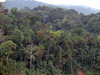
A forest is an area of land dominated by trees. Hundreds of definitions of forest are used throughout the world, incorporating factors such as tree density, tree height, land use, legal standing, and ecological function. The United Nations' Food and Agriculture Organization (FAO) defines a forest as, "Land spanning more than 0.5 hectares with trees higher than 5 meters and a canopy cover of more than 10 percent, or trees able to reach these thresholds in situ. It does not include land that is predominantly under agricultural or urban use." Using this definition, Global Forest Resources Assessment 2020 found that forests covered 4.06 billion hectares, or approximately 31 percent of the world's land area in 2020.

<span class="mw-page-title-main">Biomass (ecology)</span> Total mass of living organisms in a given area (all species or selected species)

Biomass is the mass of living biological organisms in a given area or ecosystem at a given time. Biomass can refer to species biomass, which is the mass of one or more species, or to community biomass, which is the mass of all species in the community. It can include microorganisms, plants or animals. The mass can be expressed as the average mass per unit area, or as the total mass in the community.

<span class="mw-page-title-main">Grassland</span> Area with vegetation dominated by grasses

A grassland is an area where the vegetation is dominated by grasses (Poaceae). However, sedge (Cyperaceae) and rush (Juncaceae) can also be found along with variable proportions of legumes, like clover, and other herbs. Grasslands occur naturally on all continents except Antarctica and are found in most ecoregions of the Earth. Furthermore, grasslands are one of the largest biomes on earth and dominate the landscape worldwide. There are different types of grasslands: natural grasslands, semi-natural grasslands, and agricultural grasslands. They cover 31–69% of the Earth's land area.

<span class="mw-page-title-main">Savanna</span> Mixed woodland-grassland ecosystem

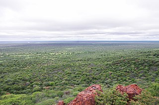
A savanna or savannah is a mixed woodland-grassland ecosystem characterised by the trees being sufficiently widely spaced so that the canopy does not close. The open canopy allows sufficient light to reach the ground to support an unbroken herbaceous layer consisting primarily of grasses. According to Britannica, there exists four savanna forms; savanna woodland where trees and shrubs form a light canopy, tree savanna with scattered trees and shrubs, shrub savanna with distributed shrubs, and grass savanna where trees and shrubs are mostly nonexistent.

<span class="mw-page-title-main">Urban ecology</span> Scientific study of living organisms

Urban ecology is the scientific study of the relation of living organisms with each other and their surroundings in an urban environment. An urban environment refers to environments dominated by high-density residential and commercial buildings, paved surfaces, and other urban-related factors that create a unique landscape. The goal of urban ecology is to achieve a balance between human culture and the natural environment.

This glossary of ecology is a list of definitions of terms and concepts in ecology and related fields. For more specific definitions from other glossaries related to ecology, see Glossary of biology, Glossary of evolutionary biology, and Glossary of environmental science.

<span class="mw-page-title-main">Habitat conservation</span> Management practice for protecting types of environments

Habitat conservation is a management practice that seeks to conserve, protect and restore habitats and prevent species extinction, fragmentation or reduction in range. It is a priority of many groups that cannot be easily characterized in terms of any one ideology.

<span class="mw-page-title-main">Environmental degradation</span> Any change or disturbance to the environment perceived to be deleterious or undesirable

Environmental degradation is the deterioration of the environment through depletion of resources such as quality of air, water and soil; the destruction of ecosystems; habitat destruction; the extinction of wildlife; and pollution. It is defined as any change or disturbance to the environment perceived to be deleterious or undesirable.

<span class="mw-page-title-main">Rangeland</span> Biomes which can be grazed by animals or livestock (grasslands, woodlands, prairies, etc)

Rangelands are grasslands, shrublands, woodlands, wetlands, and deserts that are grazed by domestic livestock or wild animals. Types of rangelands include tallgrass and shortgrass prairies, desert grasslands and shrublands, woodlands, savannas, chaparrals, steppes, and tundras. Rangelands do not include forests lacking grazable understory vegetation, barren desert, farmland, or land covered by solid rock, concrete and/or glaciers.

<span class="mw-page-title-main">Habitat destruction</span> Process by which a natural habitat becomes incapable of supporting its native species

Habitat destruction is the process by which a natural habitat becomes incapable of supporting its native species. The organisms that previously inhabited the site are displaced or dead, thereby reducing biodiversity and species abundance. Habitat destruction is the leading cause of biodiversity loss. Fragmentation and loss of habitat have become one of the most important topics of research in ecology as they are major threats to the survival of endangered species.

<span class="mw-page-title-main">Ecosystem ecology</span> Study of living and non-living components of ecosystems and their interactions

Ecosystem ecology is the integrated study of living (biotic) and non-living (abiotic) components of ecosystems and their interactions within an ecosystem framework. This science examines how ecosystems work and relates this to their components such as chemicals, bedrock, soil, plants, and animals.

<span class="mw-page-title-main">Historical ecology</span>

Historical ecology is a research program that focuses on the interactions between humans and their environment over long-term periods of time, typically over the course of centuries. In order to carry out this work, historical ecologists synthesize long-series data collected by practitioners in diverse fields. Rather than concentrating on one specific event, historical ecology aims to study and understand this interaction across both time and space in order to gain a full understanding of its cumulative effects. Through this interplay, humans adapt to and shape the environment, continuously contributing to landscape transformation. Historical ecologists recognize that humans have had world-wide influences, impact landscape in dissimilar ways which increase or decrease species diversity, and that a holistic perspective is critical to be able to understand that system.

<span class="mw-page-title-main">Human impact on the nitrogen cycle</span>

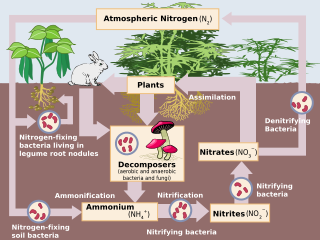
Human impact on the nitrogen cycle is diverse. Agricultural and industrial nitrogen (N) inputs to the environment currently exceed inputs from natural N fixation. As a consequence of anthropogenic inputs, the global nitrogen cycle (Fig. 1) has been significantly altered over the past century. Global atmospheric nitrous oxide (N2O) mole fractions have increased from a pre-industrial value of ~270 nmol/mol to ~319 nmol/mol in 2005. Human activities account for over one-third of N2O emissions, most of which are due to the agricultural sector. This article is intended to give a brief review of the history of anthropogenic N inputs, and reported impacts of nitrogen inputs on selected terrestrial and aquatic ecosystems.

Novel ecosystems are human-built, modified, or engineered niches of the Anthropocene. They exist in places that have been altered in structure and function by human agency. Novel ecosystems are part of the human environment and niche, they lack natural analogs, and they have extended an influence that has converted more than three-quarters of wild Earth. These anthropogenic biomes include technoecosystems that are fuelled by powerful energy sources including ecosystems populated with technodiversity, such as roads and unique combinations of soils called technosols. Vegetation associations on old buildings or along field boundary stone walls in old agricultural landscapes are examples of sites where research into novel ecosystem ecology is developing.

<span class="mw-page-title-main">Land</span> Earths dry surface

Land, also known as dry land, ground, or earth, is the solid terrestrial surface of Earth not submerged by the ocean or another body of water. It makes up 29.2% of Earth's surface and includes all continents and islands. Earth's land surface is almost entirely covered by regolith, a layer of rock, soil, and minerals that forms the outer part of the crust. Land plays important roles in Earth's climate system, being involved in the carbon cycle, nitrogen cycle, and water cycle. One third of land is covered in trees, another third is used for agriculture, and one tenth is covered in permanent snow and glaciers. The remainder consists of desert, savannah, and prairie.

<span class="mw-page-title-main">Erle Ellis</span> American environmental scientist

Erle Christopher Ellis is an American environmental scientist. Ellis's work investigates the causes and consequences of long-term ecological changes caused by humans at local to global scales, including those related to the Anthropocene. As of 2015 he is a professor of Geography and Environmental Systems at the University of Maryland, Baltimore County where he directs the Laboratory for Anthroecology.

<span class="mw-page-title-main">Biodiversity loss</span> Extinction of species and local ecosystem loss reduction or loss of species in a given habitat

Biodiversity loss includes the worldwide extinction of different species, as well as the local reduction or loss of species in a certain habitat, resulting in a loss of biological diversity. The latter phenomenon can be temporary or permanent, depending on whether the environmental degradation that leads to the loss is reversible through ecological restoration/ecological resilience or effectively permanent. The current global extinction, has resulted in a biodiversity crisis being driven by human activities which push beyond the planetary boundaries and so far has proven irreversible.

<span class="mw-page-title-main">Woody plant encroachment</span> Vegetation cover change

Woody plant encroachment is a natural phenomenon characterised by the increase in density of woody plants, bushes and shrubs, at the expense of the herbaceous layer, grasses and forbs. It predominantly occurs in grasslands, savannas and woodlands and can cause biome shifts from open grasslands and savannas to closed woodlands. The term bush encroachment refers to the expansion of native plants and not the spread of alien invasive species. It is thus defined by plant density, not species. Bush encroachment is often considered an ecological regime shift and can be a symptom of land degradation. The phenomenon is observed across different ecosystems and with different characteristics and intensities globally.

Agricultural expansion describes the growth of agricultural land especially in the 20th and 21st centuries.

References

  1. Ellis, Erle C; Ramankutty, Navin (October 2008). "Putting people in the map: anthropogenic biomes of the world". Frontiers in Ecology and the Environment. 6 (8): 439–447. Bibcode:2008FrEE....6..439E. doi: 10.1890/070062 . ISSN   1540-9295.
  2. 1 2 Ellis, Erle C.; Gauthier, Nicolas; Klein Goldewijk, Kees; Bliege Bird, Rebecca; Boivin, Nicole; Díaz, Sandra; Fuller, Dorian Q.; Gill, Jacquelyn L.; Kaplan, Jed O.; Kingston, Naomi; Locke, Harvey; McMichael, Crystal N. H.; Ranco, Darren; Rick, Torben C.; Shaw, M. Rebecca (2021-04-27). "People have shaped most of terrestrial nature for at least 12,000 years". Proceedings of the National Academy of Sciences. 118 (17): e2023483118. Bibcode:2021PNAS..11823483E. doi: 10.1073/pnas.2023483118 . ISSN   0027-8424. PMC   8092386 . PMID   33875599.
  3. 1 2 3 4 Ellis, E. C.; Ramankutty, N. (2008). "Putting people in the map: anthropogenic biomes of the world". Frontiers in Ecology and the Environment. 6 (8): 439–447. Bibcode:2008FrEE....6..439E. doi: 10.1890/070062 . S2CID   3598526.
  4. Chapin III, F Stuart; Matson, Pamela A; Vitousek, Peter M (2012). Principles of Terrestrial Ecosystem Ecology (Second ed.). Springer. ISBN   978-1-4419-9504-9.
  5. National Geographic Society (2014). National Geographic Atlas of the World (10th ed.). National Geographic. ISBN   978-1-4262-1354-0.
  6. 1 2 3 Ellis, Erle C.; Gauthier, Nicolas; Klein Goldewijk, Kees; Bliege Bird, Rebecca; Boivin, Nicole; Díaz, Sandra; Fuller, Dorian Q.; Gill, Jacquelyn L.; Kaplan, Jed O.; Kingston, Naomi; Locke, Harvey; McMichael, Crystal N. H.; Ranco, Darren; Rick, Torben C.; Shaw, M. Rebecca; Stephens, Lucas; Svenning, Jens-Christian; Watson, James E. M. (27 April 2021). "People have shaped most of terrestrial nature for at least 12,000 years". Proceedings of the National Academy of Sciences. 118 (17): e2023483118. Bibcode:2021PNAS..11823483E. doi: 10.1073/pnas.2023483118 . ISSN   0027-8424. PMC   8092386 . PMID   33875599.
  7. Keith, DA (2020). "T7 Intensive land-use biome". In Keith, D.A.; Ferrer-Paris, J.R.; Nicholson, E.; Kingsford, R.T. (eds.). The IUCN Global Ecosystem Typology 2.0: Descriptive profiles for biomes and ecosystem functional groups. Gland, Switzerland: IUCN. doi:10.2305/IUCN.CH.2020.13.en. ISBN   978-2-8317-2077-7. S2CID   241360441.
  8. 1 2 Botkin, Daniel B. (2017). "Chapter 10: People Have Changed the Environment Only Since the Industrial/Scientific Age.". 25 Myths That Are Destroying the Environment: What Many Environmentalists Believe and Why They Are Wrong. Taylor Trade Publishing. pp. 95–102.
  9. 1 2 3 4 5 6 7 Ellis, E. C. (2011). Anthropogenic transformation of the terrestrial biosphere.Philosophical Transactions of the Royal Society of London A: Mathematical, Physical and Engineering Sciences, 369(1938), 1010-1035.
  10. 1 2 3 4 5 6 7 8 Ellis, E. C., Klein Goldewijk, K., Siebert, S., Lightman, D., & Ramankutty, N. (2010). Anthropogenic transformation of the biomes, 1700 to 2000. Global Ecology and Biogeography, 19(5), 589-606.
  11. 1 2 Alessa, L., & Chapin, F. S. (2008). Anthropogenic biomes: a key contribution to earth-system science. Trends in Ecology & Evolution, 23(10), 529-531.
  12. 1 2 3 4 5 6 7 8 9 10 11 "Anthrome Maps".
  13. 1 2 3 4 5 Ellis, E. C. (2013). Sustaining biodiversity and people in the world's anthropogenic biomes. Current Opinion in Environmental Sustainability, 5(3), 368-372.
  14. 1 2 3 Martin, Laura J.; Adams, Rachel I.; Bateman, Ashley; Bik, Holly M.; Hawks, John; Hird, Sarah M.; Hughes, David; Kembel, Steven W.; Kinney, Kerry; Kolokotronis, Sergios-Orestis; Levy, Gabriel; McClain, Craig; Meadow, James F.; Medina, Raul F.; Mhuireach, Gwynne (2015). "Evolution of the indoor biome". Trends in Ecology & Evolution. 30 (4): 223–232. doi:10.1016/j.tree.2015.02.001. ISSN   0169-5347. PMID   25770744. S2CID   19246688.
  15. Zimmer, Carl (2015). "The Next Frontier: The Great Indoors". The New York Times.
  16. Bertone, Matthew A.; Leong, Misha; Bayless, Keith M.; Malow, Tara L. F.; Dunn, Robert R.; Trautwein, Michelle D. (2016). "Arthropods of the great indoors: characterizing diversity inside urban and suburban homes". PeerJ. 4: e1582. doi: 10.7717/peerj.1582 . ISSN   2167-8359. PMC   4727974 . PMID   26819844.
  17. Ecosystem approach to Aquaculture management and biodiversity conservation in a Mediterranean coastal wetland: case study of Doniana marshes (Andalucia, Spain) , United Nations Environmental Program / Mediterranean Action Plan, Tunis 2012.
  18. 1 2 3 Ellis, E. C. (2015). Ecology in an Anthropogenic Biosphere. Ecological Monographs.
  19. 1 2 3 Martin, L. J., Quinn, J. E., Ellis, E. C., Shaw, M. R., Dorning, M. A., Hallett, L. M., ... & Michel, N. L. (2014). Conservation opportunities across the world's anthromes. Diversity and distributions, 20(7), 745-755.