General Edward Lawrence Logan International Airport, also known as Logan International Airport and commonly as Boston Logan, Logan Airport or simply Logan, is an international airport that is located mostly in East Boston and partially in Winthrop, Massachusetts, United States. It opened in 1923, covers 2,384 acres (965 ha), has six runways and four passenger terminals, and employs an estimated 16,000 people. It is the largest airport in both the Commonwealth of Massachusetts and the New England region in terms of passenger volume and cargo handling, the 16th-busiest airport in the United States, as well as the busiest airport in the Northeast outside the New York metropolitan area. The airport saw 42 million passengers in 2019, the most in its history. It is named after General Edward Lawrence Logan, a 20th-century war hero native to Boston.

Winthrop is a city in Suffolk County, Massachusetts, United States. The population was 19,316 at the 2020 census. Winthrop is an ocean-side suburban community in Greater Boston situated at the north entrance to Boston Harbor, close to Logan International Airport. It is located on a peninsula, 1.6 square miles (4.2 km2) in area, connected to Revere by a narrow isthmus and to East Boston by a bridge over the harbor inlet to the Belle Isle Marsh Reservation. Settled in 1630, Winthrop is one of the oldest communities in the United States. It is also one of the smallest and most densely populated municipalities in Massachusetts. It is one of the four cities that compose Suffolk County. It is the southernmost part of the North Shore, with a 7-mile (11 km) shoreline that provides views of the Atlantic Ocean to the east and of the Boston skyline to the west.

East Boston, nicknamed Eastie, is a neighborhood of Boston, Massachusetts with over 45,000 residents. Annexed by the city of Boston in 1836, it is bordered by the cities of Winthrop, Revere, and Chelsea to the east, north, and northwest. It is separated from the Boston neighborhood of Charlestown and downtown Boston by Boston Harbor to the west and south. The footprint of the East Boston neighborhood as it is known today was created in the 1940s by connecting five of the inner harbor islands using land fill.
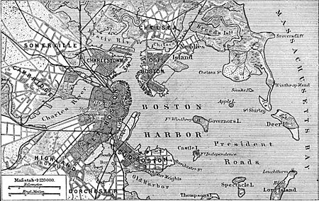
The Boston Harbor Islands National Recreation Area is a national recreation area situated among the islands of Boston Harbor of Boston, Massachusetts. The area is made up of a collection of islands, together with a former island and a peninsula, many of which are open for public recreation and some of which are very small and best suited for wildlife. The area is run by the Boston Harbor Islands Partnership. It includes the Boston Harbor Islands State Park, managed by the Commonwealth of Massachusetts. Twenty-one of the 34 islands in the area are also included in the Boston Harbor Islands Archeological District.

Boston Harbor is a natural harbor and estuary of Massachusetts Bay, and is located adjacent to the city of Boston, Massachusetts. It is home to the Port of Boston, a major shipping facility in the northeastern United States.
Hangman Island, also known as Hayman's Island, is an island in the Quincy Bay area of the Boston Harbor Islands National Recreation Area. The island is a barren outcrop of bedrock, with a permanent size of half an acre rising to only three feet above sea level, plus an intertidal zone of a further 5 acres (20,000 m2). Access is by private boat only.
The Graves is an aggregation of rock outcroppings in Massachusetts Bay, Massachusetts, United States. Situated some 11 miles (18 km) offshore of downtown Boston, it is the outermost island in the Boston Harbor Islands National Recreation Area.

Spectacle Island is a 114-acre island in Boston Harbor, 4 miles (6.4 km) offshore of downtown Boston, Massachusetts. It is part of the city of Boston. The island has a varied history, and today is a public park with a marina, visitor center, cafe, lifeguarded swimming beach, and five miles of walking trails, forming part of the Boston Harbor Islands National Recreation Area. It is served all year by ferries from Boston, and on weekends and summer weekdays by a shuttle boat to and from nearby islands.
HMS Somerset was a 70-gun third-rate ship of the line of the Royal Navy, built at Chatham Dockyard to the draught specified by the 1745 Establishment, and launched on 18 July 1748. She was the third vessel of the Royal Navy to bear the name. Somerset was involved in several notable battles of the Seven Years' War and the American Revolutionary War. She was wrecked in a storm in 1778 when she ran aground off of Provincetown, on Cape Cod, Massachusetts.

Peddocks Island is one of the largest islands in Boston Harbor. Since 1996 it has formed part of the Boston Harbor Islands National Recreation Area. Managed by the Department of Conservation and Recreation, the island is home to the now-defunct Fort Andrews, active in harbor defense from 1904 to the end of World War II, on its eastern end, and a group of privately owned cottages on its western end. Campsites are also on the eastern end. Ferry service between Peddocks Island and Georges Island is provided on a seasonal basis.

Bumpkin Island, also known as Round Island, Bomkin Island, Bumkin Island, or Ward's Island, is an island in the Hingham Bay area of the Boston Harbor. In 1902, Albert Burrage, a Boston philanthropist, had a summer hospital opened on the island for children with physical disabilities. During World War I the island was used by the U.S. Navy. Starting around 1940, the island was used as a facility for polio patients. However, the hospital closed during World War II and burned down in 1945. Since 1996, it is part of the Boston Harbor Islands National Recreation Area. The island has an area of 30 acres (120,000 m2), plus an intertidal zone of a further 31 acres (130,000 m2). It is composed of a central drumlin with an elevation of 70 feet (21 m) above sea level, surrounded by a rock-strewn shoreline. A sand spit, exposed at low tide, connects the eastern end of the island to Sunset Point in Hull.
Calf Island, also known as Apthorps Island, is a windswept island situated some 9 miles (14 km) offshore of downtown Boston in the Boston Harbor Islands National Recreation Area. The island has a permanent size of 18 acres (73,000 m2), plus an intertidal zone of a further 16 acres (65,000 m2), and has a thin layer of soil that supports vegetation including wild cherry, beach plum, grasses, chives, and mock orange. Access is by private boat only.

Great Brewster Island is one of the outer islands in the Boston Harbor Islands National Recreation Area, situated some 9 miles (14 km) offshore of downtown Boston. The island has a permanent size of 18 acres (73,000 m2), plus an intertidal zone of a further 49 acres (200,000 m2). Unlike the other outer islands, which are low-lying outcroppings of bedrock, Great Brewster is a drumlin which reaches a height of over 100 feet above sea level. It has vegetation cover consisting of Apple Trees, Pear Trees, Sumac, Beach Roses, Grasses and Common Reeds, together with a large Gull colony. The birds are aggressive during nesting season and access by humans, which is by private boat only, is discouraged during that time.

Long Island is located in Boston Harbor, Massachusetts. The island is part of the City of Boston, and of the Boston Harbor Islands National Recreation Area. The island is 1.75 miles (2.82 km) long and covers 225 acres (0.9 km2).

Deer Island is a peninsula in Boston, Massachusetts. Since 1996, it has been part of the Boston Harbor Islands National Recreation Area. Although still an island by name, Deer Island has been connected to the mainland since the former Shirley Gut channel, which once separated the island from the town of Winthrop, was filled in by the 1938 New England hurricane. Today, Deer Island is the location of the Deer Island Waste Water Treatment Plant, whose 150-foot-tall (46 m) egg-like sludge digesters are major harbor landmarks.

Snake Island, also known as Bare Island, is an island in Boston Harbor. The island is part of the Boston Harbor Islands National Recreation Area and is situated in the inner harbor between the town of Winthrop and the reclaimed land that forms Logan International Airport. It is part of the Town of Winthrop. It is named for its serpentine shape, and has a permanent size of 3 acres (12,000 m2), and rises to a height of 10 feet (3.0 m) above sea level.
Governors Island was an island in Boston Harbor in the U.S. state of Massachusetts. The island was subsumed by land reclamation for the construction and extension of Logan International Airport.

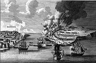
The Battle of Chelsea Creek was the second military engagement of the Boston campaign of the American Revolutionary War. It is also known as the Battle of Noddle's Island, Battle of Hog Island and the Battle of the Chelsea Estuary. This battle was fought on May 27 and 28, 1775, on Chelsea Creek and on salt marshes, mudflats, and islands of Boston Harbor, northeast of the Boston peninsula. Most of these areas have since been united with the mainland by land reclamation and are now part of East Boston, Chelsea, Winthrop, and Revere.

Noddle's Island was historically one of the Boston Harbor Islands off Boston, Massachusetts. Most of the original land of Noddle's Island now makes up the southern part of the neighborhood of East Boston; it is now part of the mainland since the strait connecting Noddle's Island to Hog Island and that connecting Hog Island to the mainland city of Revere were filled in the early 20th century. The original contours of Noddle's Island were also greatly obscured by the 20th-century construction of Logan International Airport, which filled the tidal flats between Noddle's Island and Governor's, Bird, and Apple islands to its east. In some sources it is spelled "Noodle's Island".

The Misery Islands are an 87-acre (350,000 m2) nature reserve established in 1935 in Salem Sound close to the Salem Harbor in Salem, Massachusetts. It is managed by the Trustees of Reservations. The islands are a part of the city of Salem, although they are much closer to the city of Beverly, in whose aquatic territory they lie.