Esri is an American multinational geographic information system (GIS) software company. It is best known for its ArcGIS products. With a 43% market share, Esri is the world's leading supplier of GIS software, web GIS and geodatabase management applications. The company is headquartered in Redlands, California.

ArcIMS is a Web Map Server produced by Esri accessible through a web browser. It is a GIS that is designed to serve maps across the Internet. Sometimes these maps are just static images allowing simple panning and zooming, while others are more complex pages. Examples of interactive maps served with ArcIMS include maps with layers that can be turned on and off, or with features containing attributes that can be queried.
A GIS software program is a computer program to support the use of a geographic information system, providing the ability to create, store, manage, query, analyze, and visualize geographic data, that is, data representing phenomena for which location is important. The GIS software industry encompasses a broad range of commercial and open-source products that provide some or all of these capabilities within various information technology architectures.

ArcView GIS was a geographic information system software product produced by ESRI. It was replaced by new product line, ArcGIS, in 2000. Regardless of it being discontinued and replaced, some users still find the software useful and hold the opinion it is a superior product for some tasks.
A Web Map Service (WMS) is a standard protocol developed by the Open Geospatial Consortium in 1999 for serving georeferenced map images over the Internet. These images are typically produced by a map server from data provided by a GIS database.
Spatial network analysis software packages are analytic software used to prepare graph-based analysis of spatial networks. They stem from research fields in transportation, architecture, and urban planning. The earliest examples of such software include the work of Garrison (1962), Kansky (1963), Levin (1964), Harary (1969), Rittel (1967), Tabor (1970) and others in the 1960s and 70s. Specific packages address to suit their domain-specific needs, including TransCAD for transportation, GIS for planning and geography, and Axman for Space syntax researchers.
ArcSDE is a server-software sub-system that aims to enable the usage of Relational Database Management Systems for spatial data. The spatial data may then be used as part of a geodatabase.

The shapefile format is a geospatial vector data format for geographic information system (GIS) software. It is developed and regulated by Esri as a mostly open specification for data interoperability among Esri and other GIS software products. The shapefile format can spatially describe vector features: points, lines, and polygons, representing, for example, water wells, rivers, and lakes. Each item usually has attributes that describe it, such as name or temperature.
ArcGIS is a family of client, server and online geographic information system (GIS) software developed and maintained by Esri. ArcGIS was first released in 1999 and originally was released as ARC/INFO, a command line based GIS system for manipulating data. ARC/INFO was later merged into ArcGIS Desktop, which was eventually superseded by ArcGIS Pro in 2015. ArcGIS Pro works in 2D and 3D for cartography and visualization, and includes artificial Intelligence (AI).
Smallworld is the brand name of a portfolio of GIS software provided by GE Digital, a division of General Electric. The software was originally created by the Smallworld company founded in Cambridge, England, in 1989 by Dick Newell and others. Smallworld grew to become the global market leader for GIS in 2010 focused on utilities and communications and remains strong in this sector today. Smallworld was acquired by GE Energy in September 2000.

Java Unified Mapping Program (JUMP) is a Java based vector and raster GIS and programming framework. Current development continues under the OpenJUMP name.
ArcInfo is a full-featured geographic information system produced by Esri, and is the highest level of licensing in the ArcGIS Desktop product line. It was originally a command-line based system. The command-line processing abilities are now available through the GUI of the ArcGIS Desktop product.
ArcGIS Server is the core server geographic information system (GIS) software made by Esri. ArcGIS Server is used for creating and managing GIS Web services, applications, and data. ArcGIS Server is typically deployed on-premises within the organization’s service-oriented architecture (SOA) or off-premises in a cloud computing environment.
ArcMap is the main component of Esri's ArcGIS suite of geospatial processing programs, and is used primarily to view, edit, create, and analyze geospatial data. ArcMap allows the user to explore data within a data set, symbolize features accordingly, and create maps. This is done through two distinct sections of the program, the table of contents and the data frame. In October 2020, it was announced that there are no plans to release 10.9 in 2021, and that ArcMap would no longer be supported after March 1, 2026. Esri are encouraging their users to transition to ArcGIS Pro.
TOXMAP was a geographic information system (GIS) from the United States National Library of Medicine (NLM) that was deprecated on December 16, 2019. The application used maps of the United States to help users explore data from the United States Environmental Protection Agency's (EPA) Toxics Release Inventory (TRI) and Superfund programs with visual projections and maps.
ArcObjects is a development environment of the ArcGIS family of applications. Using Visual Basic for Applications, C# or Java SDK for ArcGIS, it allows developers to extend these applications.
ArcObjects is a library of COM components that build up the foundation of the Esri's ArcGIS platform. ArcObjects is written mostly in the C++ programming language. All of the ArcGIS for Desktop applications are based on ArcObjects. Since ArcGIS is completely built on top of ArcObjects, you can make use of COM services and capabilities to fully customize and extend the ArcGIS platform —meaning that extending the ArcObjects data model can be done easily and with virtually all COM-compatible programming languages. COM enables components to be reused at a binary level. In other words, developers do not require access to the source code of ArcObjects in order to extend the ArcGIS platform. For this reason, an ArcObjects programmer can make use of any type inside the ArcObjects system without knowing the implementation details of the type. The developer only needs to know what the type is able to do. Because ArcObjects is based on the COM standard, you can easily work with it in conjunction with other COM objects and applications . As previously mentioned, the ArcGIS platform was built using ArcObjects types. In the world of ArcObjects, classes use interfaces to organize properties and methods. Put simply, classes inside ArcObjects use only COM interfaces to expose their public members and communicate with each other. When working with an ArcObjects COM class, you never work with the properties and methods of the class; rather, you always access its properties and methods via one of its implemented interfaces. As an example, when you instantiate an object, you can only use one interface. However, after instantiation, you can query for any other interface that is implemented by that object. This process is sometimes called a Query Interface (QI). Classes in ArcObjects often have many interfaces.

ArcGIS CityEngine is a commercial three-dimensional (3D) modeling program developed by Esri R&D Center Zurich and specialises in the generation of 3D urban environments. Using a procedural modeling approach, it supports the creation of detailed large-scale 3D city models. CityEngine works with architectural object placement and arrangement in the same manner that software like VUE manages terrain, ecosystems and atmosphere mapping. Unlike the traditional 3D modeling methodology which uses Computer-Aided Design (CAD) tools and techniques, CityEngine takes a different approach to shape generation via a rule-based system. It can also use Geographic Information System (GIS) datasets due to its integration with the wider Esri/ArcGIS platform. Due to this unique feature set, CityEngine has been used in academic research and built environment professions, e.g., urban planning, architecture, visualization, game development, entertainment, archeology, military and cultural heritage. CityEngine can be used within Building Information Model (BIM) workflows as well as visualizing the data of buildings in a larger urban context, enhancing its working scenario toward real construction projects.
Geographic information systems (GIS) play a constantly evolving role in geospatial intelligence (GEOINT) and United States national security. These technologies allow a user to efficiently manage, analyze, and produce geospatial data, to combine GEOINT with other forms of intelligence collection, and to perform highly developed analysis and visual production of geospatial data. Therefore, GIS produces up-to-date and more reliable GEOINT to reduce uncertainty for a decisionmaker. Since GIS programs are Web-enabled, a user can constantly work with a decision maker to solve their GEOINT and national security related problems from anywhere in the world. There are many types of GIS software used in GEOINT and national security, such as Google Earth, ERDAS IMAGINE, GeoNetwork opensource, and Esri ArcGIS.
Vector tiles, tiled vectors or vectiles are packets of geographic data, packaged into pre-defined roughly-square shaped "tiles" for transfer over the web. This is an emerging method for delivering styled web maps, combining certain benefits of pre-rendered raster map tiles with vector map data. As with the widely used raster tiled web maps, map data is requested by a client as a set of "tiles" corresponding to square areas of land of a pre-defined size and location. Unlike raster tiled web maps, however, the server returns vector map data, which has been clipped to the boundaries of each tile, instead of a pre-rendered map image.
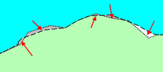
A Sliver Polygon, in the context of Geographic Information Systems (GIS), is a small polygon found in vector data that is an artifact of error rather than representing a real-world feature. They have been a recognized source of error since overlay was first invented in the 1970s.