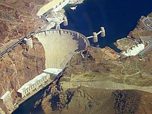
Hoover Dam is a concrete arch-gravity dam in the Black Canyon of the Colorado River, on the border between the U.S. states of Nevada and Arizona. Constructed between 1931 and 1936, during the Great Depression, it was dedicated on September 30, 1935, by President Franklin D. Roosevelt. Its construction was the result of a massive effort involving thousands of workers, and cost over 100 lives. Bills passed by Congress during its construction referred to it as Hoover Dam, but the Roosevelt administration named it Boulder Dam. In 1947, Congress restored the name Hoover Dam.

A dam is a barrier that stops or restricts the flow of surface water or underground streams. Reservoirs created by dams not only suppress floods but also provide water for activities such as irrigation, human consumption, industrial use, aquaculture, and navigability. Hydropower is often used in conjunction with dams to generate electricity. A dam can also be used to collect or store water which can be evenly distributed between locations. Dams generally serve the primary purpose of retaining water, while other structures such as floodgates or levees are used to manage or prevent water flow into specific land regions.

A diversion dam is a dam that diverts all or a portion of the flow of a river from its natural course. Diversion dams do not generally impound water in a reservoir; instead, the water is diverted into an artificial water course or canal, which may be used for irrigation or return to the river after passing through hydroelectric generators, flow into a different river or be itself dammed forming an onground or groundwater reservoir or a storm drain.

The St. Francis Dam, or the San Francisquito Dam, was a concrete gravity dam located in San Francisquito Canyon in northern Los Angeles County, California, United States, that was built between 1924 and 1926. The dam failed catastrophically in 1928, killing at least 431 people in the subsequent flood, in what is considered to have been one of the worst American civil engineering disasters of the 20th century and the third-greatest loss of life in California history.

A gravity dam is a dam constructed from concrete or stone masonry and designed to hold back water by using only the weight of the material and its resistance against the foundation. Gravity dams are designed so that each section of the dam is stable and independent of any other dam section.
An arch dam is a concrete dam that is curved upstream in plan. The arch dam is designed so that the force of the water against it, known as hydrostatic pressure, presses against the arch, causing the arch to straighten slightly and strengthening the structure as it pushes into its foundation or abutments. An arch dam is most suitable for narrow canyons or gorges with steep walls of stable rock to support the structure and stresses. Since they are thinner than any other dam type, they require much less construction material, making them economical and practical in remote areas.

Pathfinder Dam is a masonry dam, located on the North Platte River, approximately 47 miles (76 km) southwest of Casper, Wyoming. It was constructed from 1905 to 1909 as part of the North Platte Project and has been modified several times since then. It is included on the National Register of Historic Places. Construction of the dam created Pathfinder Reservoir which provides water storage for 226,000 acres (910 km2) of irrigation in Wyoming and Nebraska. The dam is named for General John Charles Fremont, who had explored the area in 1842 and was nicknamed the "Pathfinder of the West."

Roller-compacted concrete (RCC) or rolled concrete (rollcrete) is a special blend of concrete that has essentially the same ingredients as conventional concrete but in different ratios, and increasingly with partial substitution of fly ash for portland cement. The partial substitution of fly ash for Portland Cement is an important aspect of RCC dam construction because the heat generated by fly ash hydration is significantly less than the heat generated by portland cement hydration. This in turn reduces the thermal loads on the concrete and reduces the potential for thermal cracking to occur. RCC is a mix of cement/fly ash, water, sand, aggregate and common additives, but contains much less water. The produced mix is drier and essentially has no slump. RCC is placed in a manner similar to road paving; the material is delivered by dump trucks or conveyors, spread by small bulldozers or specially modified asphalt pavers, and then compacted by vibratory rollers.
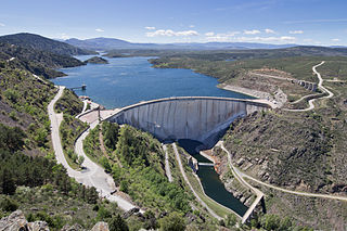
El Atazar Dam is an arch dam built near Madrid, Spain on the Lozoya River, very close to where the Lozoya joins the Jarama. The curved design of the dam is optimum for the narrow gorge in which it was built to retain water in the reservoir. Arch dams are thin and require less material to construct than other dam types.

The Canning Dam and reservoir are a major source of fresh water for the city of Perth, Western Australia. The dam is situated on the Darling Scarp and is an impoundment of the Canning River. It is noted for its innovative structural and hydraulic design that was considered to be at the forefront of concrete gravity dam design at the time of construction in from 1933 to its completion 1940.

An embankment dam is a large artificial dam. It is typically created by the placement and compaction of a complex semi-plastic mound of various compositions of soil or rock. It has a semi-pervious waterproof natural covering for its surface and a dense, impervious core. This makes the dam impervious to surface or seepage erosion. Such a dam is composed of fragmented independent material particles. The friction and interaction of particles binds the particles together into a stable mass rather than by the use of a cementing substance.

A buttress dam or hollow dam is a dam with a solid, water-tight upstream side that is supported at intervals on the downstream side by a series of buttresses or supports. The dam wall may be straight or curved. Most buttress dams are made of reinforced concrete and are heavy, pushing the dam into the ground. Water pushes against the dam, but the buttresses are inflexible and prevent the dam from falling over.

Auburn Dam was a proposed concrete arch dam on the North Fork of the American River east of the town of Auburn, California, in the United States, on the border of Placer and El Dorado Counties. Slated to be completed in the 1970s by the U.S. Bureau of Reclamation, it would have been the tallest concrete dam in California and one of the tallest in the United States, at a height of 680 feet (210 m) and storing 2,300,000 acre-feet (2.8 km3) of water. Straddling a gorge downstream of the confluence of the North and Middle Forks of the American River and upstream of Folsom Lake, it would have regulated water flow and provided flood control in the American River basin as part of Reclamation's immense Central Valley Project.

Buffalo Bill Dam is a concrete arch-gravity dam on the Shoshone River in the U.S. state of Wyoming. Originally 325-foot (99 m), it was the tallest dam in the world when it opened in 1910; a 25-foot (7.6 m) extension was added in 1992 in one of numerous changes and improvements to the structure and its support facilities, which include two full time power generators and two seasonal operations added between 1920 and 1994, and a 2.8-mile (4.5 km) irrigation tunnel completed in 1939.
Owyhee Dam is a concrete arch-gravity dam on the Owyhee River in Eastern Oregon near Adrian, Oregon, United States. Completed in 1932 during the Great Depression, the dam generates electricity and provides irrigation water for several irrigation districts in Oregon and neighboring Idaho. At the time of completion, it was the tallest dam of its type in the world. The dam is part of the Owyhee Dam Historic District, which is listed on the National Register of Historic Places.

Canyon Ferry Dam is a concrete gravity dam in a narrow valley of the Missouri River, United States, where the Big Belt Mountains and the Spokane Hills merge, approximately 68 miles (109 km) downstream from the confluence of the Gallatin, Madison, and Jefferson rivers, and about 20 miles (32 km) east of the city of Helena, Montana. The dam is for flood control, irrigation, recreation and hydroelectric power. The building of the dam created a reservoir known as Canyon Ferry Lake.

The Aldeadávila Dam is a Spanish concrete arch-gravity dam, straddling the border between Spain and Portugal on the Duero River. The nearest town is Aldeadávila de la Ribera in the Province of Salamanca, about 11.3 kilometres (7.0 mi) to the east. The nearest Portuguese town is Fornos in Bragança District, about 8 kilometres (5.0 mi) to the southwest. The Portuguese side of the river around the dam site lies within the Arribes del Duero Natural Park.
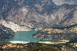
Gibraltar Dam is located on the Santa Ynez River, in southeastern Santa Barbara County, California, in the United States. Forming Gibraltar Reservoir, the dam is owned by the city of Santa Barbara. Originally constructed in 1920 and expanded in 1948, the dam and reservoir are located in a remote part of the Los Padres National Forest.

Cheesman Dam is a 211-foot-tall (64 m) masonry curved gravity dam on the South Platte River located in Colorado. It was the tallest of its type in the world when completed in 1905. The primary purpose of the dam is water supply and it was named for Colorado businessman, Walter Cheesman. In 1973 it was designated a Historic Civil Engineering Landmark. Denver Water purchased the reservoir and related facilities in 1918.
This glossary of structural engineering terms pertains specifically to structural engineering and its sub-disciplines. Please see Glossary of engineering for a broad overview of the major concepts of engineering.