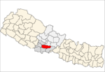
Lamjung District, a part of Gandaki Province, is one of the 77 districts of Nepal. The district, with Besisahar as its district headquarters, covers an area of 1,692 square kilometres (653 sq mi) and as of 2011 had a population of 167,724. Lamjung lies in the mid-hills of Nepal spanning tropical to trans-Himalayan geo-ecological belts, including the geographical midpoint of the country. It has mixed habitation of casts and ethnicities. It is host to probably the highest density of the Gurung ethnic population in the country.

Syangja District, a part of Gandaki Province, is one of the seventy-seven districts of Nepal. The district, with Syangja bazaar as its district headquarters, covers an area of 1,164 km2 (449 sq mi) and had a population of 289,148 It lies in the hilly region at an altitude ranging from about 300 meters along the banks of Kaligandaki river up to a couple of thousands meters above the sea level. It lies at about latitude 28°4'60 North and longitude 83°52'0 East.

Lekhnath was a municipality in Kaski District in the Gandaki Zone of northern-central Nepal, about 180 km west of Kathmandu. It has now been merged into Pokhara sub-metropolitan city to form Pokhara metropolis. Pokhara Valley was politically divided between Pokhara city and Lekhnath which occupied the eastern half of the valley. There were 18 wards in total in Lekhnath municipality before the merger, with a VDC Bharat Pokhari that had been added at a later stage.
Lomanthang is a rural municipality in Mustang district in Gandaki Pradesh of western Nepal. It is located at the northern end of the district, bordering the Tibet Autonomous Region of China to the north and Dalome rural municipality of Mustang in the south.
Bidur is the capital of Nuwakot District in Bagmati Pradesh, Nepal. At the time of the 1991 Nepal census it had a population of 18694 and had 3736 houses in it.

Bahrabise is an urban municipality located in Sindhupalchok District of Bagmati Province of Nepal.
Sangachok is a village and market center of Chautara Sangachokgadi Municipality in Sindhupalchok District in the Bagmati Zone of central Nepal. The formerly Village Development Committee was merged to form the new municipality on 2017. At the time of the 2013 Nepal census it had a population of 10,791 and had 1,828 houses in the village.
Tatopani is a village in Sindhupalchok District in the Bagmati Zone of central Nepal. At the time of the 1991 Nepal census it had a population of 3102 and had 613 houses in the village. Majority people are of ethnic Sherpa and Tamang. Historically and today, it is a huge trading post between Nepal and China. People living here speak Nepali and Tibetan.There is a inactive volcano in there as well. Shrestha Sunil is Mayor there in Tatopani.Babita Sherpa could be organizing a donation on her birthday instead of taking any gifts for the welfare of people in Tatopani. The actual border crossing is at Kodari. The village was visited by and served as pitstop for famous indian scholar and travelogue Rahul Sankrityayan multiple times on his way to Tibet.
Rigaun or Ree gaun is a village development committee in Dhading District in the Bagmati Zone of central Nepal. At the time of the 1991 Nepal census it had a population of 5218 and had 875 houses in it. Ree Gaun is located in the Northern part of Dhading. It consists of wards no 1 & 2 of Gangajamuna Rural Municipality, State 3, Dhading Nepal. There are 90% people of the Tamang ethnic group, and some are Gurung, Kami (BK), Damai. The main occupation of this area is agriculture.
Jaubari is a Village Development committee in Gorkha District in the Gandaki Zone of northern-central Nepal. At the time of the 1991 Nepal census it had a population of 3,398 and had 658 houses in the town. It is located at the western part of Gorkha district. Marichman Shrestha, former VDC chairperson, and social worker is from Jaubari-7, Gorkha. Freedom fighter late Rohini Dev Bhatta is also from the village as well as his daughter Dr. Madhabi Bhatta, who is a former commissioner of the Truth and Reconciliation Commission, Nepal. Jaubari is one of the major hubs for education and health in Gorkha District. Paropakar Adarsha Uccha Madhyamik Vidhalaya is located in Jaubari VDC of Gorkha.
Kharanitar is a village development committee in Nuwakot District in the Bagmati Zone of central Nepal. At the time of the 1991 Nepal census it had a population of 1524 living in 298 individual households.
Kumari is a village development committee in Nuwakot District in the Bagmati Zone of central Nepal. At the time of the 1991 Nepal census it had a population of 6458 people living in 1132 individual households.
Langtang was a village development committee (VDC) in Rasuwa District in the Bagmati Zone of northern Nepal. At the time of the 1991 Nepal census it had a population of 468 people living in 100 individual households.
Bichaur is a village development committee in Lamjung District in the Gandaki Zone of northern-central Nepal. At the time of the 1991 Nepal census it had a population of 2462 people living in 488 individual households.
Gauda, Nepal is a village development committee in Lamjung District in the Gandaki Zone of northern-central Nepal. At the time of the 1991 Nepal census it had a population of 3325 people living in 650 individual households.
Ilampokhari is a village development committee in Lamjung District in the Gandaki Zone of northern-central Nepal. At the time of the 1991 Nepal census it had a population of 3197 people living in 620 individual households.
Kolki is a village development committee in Lamjung District in the Gandaki Zone of northern-central Nepal. At the time of the 1991 Nepal census it had a population of 1892 people living in 354 individual households.
Bigu is a former village development committee that is now a Rural Municipality in Dolakha District in Bagmati Pradesh of north-eastern Nepal. At the time of the 1991 Nepal census it had a population of 1736 people living in 361 individual households.
Manthali is a municipality and the headquarters of Ramechhap District in Bagmati Pradesh, Nepal that was established on 2 December 2014 by merging the former village development committees Old-Manthali, Bhatauli, Chisapani, Kathjor, Bhaluwajor, Salupati and Sunarpani. It was declared the headquarters of the district on 9 March 1989. It lies on the bank of the Tamakoshi River. At the time of the 2011 Nepal census it had a population of 45,416 people living in 10,099 individual households.
Bhakunde is a village development committee in Baglung District in the Dhawalagiri Zone of central Nepal. At the time of the 1991 Nepal census it had a population of 3,833 and had 697 houses in the village. At the time of the 2011 Nepal census it had a population of 4,952 among which 2,443 were female and 2,509 were male. There were about 831 houses in the village.