
Asan-Maina is a village located on the western shore of the United States territory of Guam. The municipality combines the names of the coastal community of Asan with Maina, a community along the slopes of the Fonte River valley to the east. Asan was the northern landing site for United States Marines during Guam's liberation from the Japanese during World War II. Asan Beach Park is part of the War in the Pacific National Historic Park. The third community comprising Asan-Maina is Nimitz Hill Annex in the hills above Asan and Maina, which is the location of the Joint Region Marianas headquarters. Asan-Maina is located in the Luchan (Western) District.

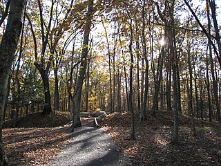
The War in the Pacific National Historical Park is a multi-unit protected area in the United States territory of Guam, which was established in 1978 in honor of those who participated in the Pacific Theater of World War II. Uniquely among the National Park System, it honors the bravery and sacrifices of all those who participated in the Pacific Theater.
The Fort Mill Ridge Civil War Trenches are battle trenches in West Virginia that were originally dug between 1861 and 1862 to be later used in 1863 for the civil war. These trenches lined with chestnut logs by the Confederate artillery during the American Civil War to defend the approaches to Romney on the Northwestern Turnpike and the South Branch Potomac River. The trenches were then refurbished between March and June 1863 by the 54th Pennsylvania Infantry and the 1st West Virginia Infantry. When Colonel Jacob M. Campbell garrisoned Union forces at Romney, camps were set up at nearby at Mechanicsburg Gap. The Confederates might have created these trenches but all throughout the war the Union had control of these trenches.

Guam Highway 1 (GH-1), also known as Marine Corps Drive, is one of the primary automobile routes in the United States territory of Guam. It runs in a southwest-to-northeast direction, from the main gate of Naval Base Guam in the southwestern village of Santa Rita in a northeasterly direction to the main gate of Andersen Air Force Base in the village of Yigo. It passes through Guam's capital, Hagåtña, as well as intersecting other territorial highways. The highway runs through tropical forest, urbanized commercial areas, and residential neighborhoods. The US military upgraded and extended the road starting in 1941. Construction ceased with the Japanese invasion in December 1941 and resumed after the Second Battle of Guam in 1944. The highway was formally dedicated to the U.S. Marine Corps by the governor in 2004.

Nimitz Hill Annex is a community and census-designated place (CDP) in Asan-Maina, Guam. It contains the geographic feature of Nimitz Hill, and is located immediately northeast of the Nimitz Hill CDP in Piti. In normal conversation, the Nimitz Hill CDP and Nimitz Hill Annex CDP are often collectively referred to as "Nimitz Hill."
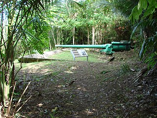
The Piti Guns or Piti Coastal Defense Guns is the site of three Vickers-type Model 3 140-millimetre (5.5 in) coastal defense guns in the War in the Pacific National Historical Park in Piti, Guam. The Japanese manufactured these Model 3 coastal defense guns in 1914. During the Japanese Occupation of Guam from 1941 to 1944, they built up defensive positions on the island. The Chamorro population was forced to work in building up these defenses, and did so here at the Piti Guns.
The Asan River is a river in the United States territory of Guam that lies entirely within the village of Asan-Maina. It originates in the highlands of Nimitz Hill Annex and flows through the Asan Inland Unit of War in the Pacific National Historical Park (WAPA) and enters the community of Asan. It then briefly re-enters WAPA at its Asan Inland Unit, with the mouth at the eastern end of Asan Memorial Park into Asan Bay. The river was thus a significant geographical feature of the Asan Invasion Beach for U.S. forces during the initial landings on Guam in July 1944.
The Ilik River Fortification II near Yona, Guam was built by Japanese forces during World War II. It was listed on the U.S. National Register of Historic Places in 1991.

The Agat Invasion Beach is a historic site in the village of Agat, Guam. The beaches of Agat were one of the landing sites of American forces in the 1944 Battle of Guam, in which the island was retaken from occupying Japanese forces. The designated historic site includes the beaches and inland areas extending between Bangi Point and Togcha Beach. Surviving remnants of the Japanese defenses on this stretch of coast include trenches and rifle pits located a short way inland, and a fortified bunker and 40mm gun emplacements at Ga'an Point. Remnants of pillboxes that had lined the beach also survive, with one at Gangi Point in relatively good condition.

The Agat World War II Amtrac is an underwater relic of World War II, located off Ga'an Point in Agat Bay on the west side of the island of Guam. It is the remains of an LVT 4, an amphibious tracked landing vehicle. It is located about 500 yards (460 m) off Agat Invasion Beach in 45 feet (14 m) of water, and was described as being in good condition when it was discovered and surveyed in 1985. These vehicles were used during the 1944 Battle of Guam, in which American forces recaptured the island from occupying Japanese forces. This particular vehicle does not appear to exhibit significant war damage. This is the most intact of the three Amtracks remaining on Guam from the 850 that participated in the battle. It was re-surveyed by maritime archaeological field schools conducted from 2009 to 2012.

Hill 40 is a militarily historic landform on the island of Guam. It is located about 325 metres (1,066 ft) east of Bangi Point, south of Agat on the island's west coast, rising to a height of 40 to 60 feet above the coastal plain, with a strategically significant view of the Agat Invasion Beach. This hill was the scene of some of the most intense fighting during the landing phase of the 1944 Battle of Guam as Allied forces sought to establish their beachhead against the defending Japanese forces. The American 4th Marine Regiment of the 1st Provisional Marine Brigade captured Hill 40 on June 21, 1944, the day of the landing. That night the Japanese launched a counteroffensive that successfully retook the hill on three occasions. The Marines regrouped and regained the hill each time. The final push came in the early morning hours of July 22. The Japanese 38th Regiment was wiped out during this military action, with 345 killed on the Bangi Point plain, immediately west of Hill 40 near the beach.

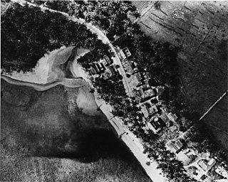
The Asan Invasion Beach is a historic site in the village of Asan, Guam. The beaches of Asan were one of the landing sites of American forces in the 1944 Battle of Guam, in which the island was retaken from occupying Japanese forces. The designated historic site includes the beaches extending between Asan Point and Adelup Point, and extends inland roughly to Guam Highway 1. It also includes the water area extending from the beach to the reef, about 100 metres (330 ft) out, an area that includes at least one abandoned Allied landing vehicle.

The Dungcas Beach Defense Guns are an old World War II Japanese fortification in the United States territory of Guam. It consists of a tunnel dug in the coral limestone of the cliffs overlooking the beach on the northeast east side of Hagåtña Bay on the west side of the island. The tunnel has two guns mounted at openings facing the beach. This fortification was built by the 48th Independent Mixed Brigade of the 29th Division of the Imperial Japanese Army, during its occupation of the island 1941–44. The guns from this position were probably fired on landing Allied forces during the 1944 Battle of Guam, in which the United States retook the island.

The Gongna Beach defenses are a collection of World War II structures built on or near Gongna Beach in Tamuning on the island of Guam, now a United States territory. These defenses were erected by the Imperial Japanese Army during its occupation of the island 1941–44. The three surviving elements were listed on the National Register of Historic Places in 1991. They are located well north of the main Allied landing areas of the 1944 Battle of Guam.
The Matgue River Valley Battle Area was the site of a decisive Allied victory during the 1944 Battle of Guam. The area was the scene of a major counterattack by Japanese forces against the Allied beachhead, in which the Japanese suffered extremely heavy casualties and were beaten back. After this attack, the remaining Japanese forces on the island retreated to the north. The area is located in the hills southwest of Asan Point along the Matgue River. The only surviving structural remnants associated with the battle are caves dug by the Japanese as defensive positions prior to the invasion.
The Mana Pillbox is an old World War II-era Japanese-built defensive fortification on the east coast of the island of Guam. It is located south of the village of Talofofo, about 50 metres (160 ft) inland from the point marking the south end of As Anite Cove. It is a structure built out of coral limestone and concrete, with an interior chamber about 3 by 1.8 metres in size. The entrance is on the south side, measuring 0.85 by 1.45 metres. There is one gun port, facing north, measuring 0.32 by .9 metres. The structure was designed to be well hidden in view from the sea and air. It was built, probably by conscripted Chamorro labor, during the Japanese occupation period 1941–44.

The Mount Tenjo Fortifications are a historic defensive gun battery site on Mount Tenjo, a hill overlooking Apra Harbor, the principal deep-water port on the island of Guam. The site includes concrete mounting pads for seven guns and the crumbling remains of a concrete command post structure. These facilities are located just below the crest of the hill on its west side. A defensive trench also extends along the top of the plateau-like hill. Unlike most early 20th-century fortifications on Guam, these facilities were built in the late 1910s by the United States Navy, and not by Japanese forces during the World War II occupation period. These are the only known surviving pre-World War II defensive fortification sites on the island. They were functionally abandoned as a result of the 1922 Washington Naval Conference. Mount Tenjo was the site of battle during the 1944 liberation of Guam.
The San Vitores Beach Japanese Fortification are the remains of World War II-era defensive positions facing the beach of Tumon Bay on the west side of the island of Guam. Located near the stairs to the beach of the Guam Reef Hotel are the remains of two concrete pillboxes built by Japanese defenders during the occupation period 1941–44. One structure, of which little more than a gun embrasure is discernible, is located in the limestone cliff about 10 metres (33 ft) inland from the high tide line, and a second is located about 10 meters south and 8 meters further inland, with only a section of roof slab and supporting columns recognizable.
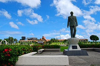
Adelup Point is limestone promontory in Hagåtña, Guam that extends into the Philippine Sea and separates Asan Bay from Hagåtña Bay. It has been the site of the Ricardo J. Bordallo Governor's Complex since 1990. Adelup is therefore a metonym for the Office of the Governor of Guam.
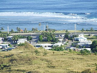
Asan is a community and census-designated place (CDP) along the western coast of the U.S. territory of Guam. Asan, along with Maina and Nimitz Hill Annex, are the three communities in the village of Asan-Maina. It is known for being the location of northern invasion beach used by the United States during the retaking of Guam in 1944.


