
The English River Thames is navigable from Cricklade or Lechlade to the sea, and this part of the river falls 71 meters (234 feet). There are 45 locks on the river, each with one or more adjacent weirs. These lock and weir combinations are used for controlling the flow of water down the river, most notably when there is a risk of flooding, and provide for navigation above the tideway.

Teddington Lock is a complex of three locks and a weir on the River Thames between Ham and Teddington in the London Borough of Richmond upon Thames, England. Historically in Middlesex, it was first built in 1810.

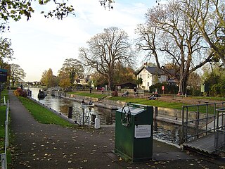
Shiplake Lock is a lock and weir situated on the River Thames in England between the villages of Shiplake and Lower Shiplake, Oxfordshire. It is just above the points where the River Loddon joins the Thames and Shiplake Railway Bridge crosses the river. The first pound lock was built by the Thames Navigation Commission in 1773.

The River Ember is a short river in the north of Surrey, England — a channel of the River Mole which splits in two south of Island Barn Reservoir, between East Molesey and Lower Green, Esher. The Ember, the larger channel, flows in an easterly and then northerly direction around the reservoir, past part of Esher; the Mole flows around the other side past West Molesey. The two rivers then flow side by side approximately north east and merge 400 metres before joining the River Thames at the eastern end of East Molesey opposite Hampton Court Palace on the south side of the last non-tidal reach, which is above Teddington Lock.
Trowlock Island is a residential island in the River Thames 450 metres (490 yd) upstream of Teddington Lock on the non-tidal Kingston reach less than 10 metres from the northern bank, in the London Borough of Richmond upon Thames, England.

The Thames Path is a National Trail following the River Thames from one of its sources near Kemble in Gloucestershire to the Woolwich foot tunnel, south east London. It is about 185 miles (298 km) long. A path was first proposed in 1948 but it only opened in 1996.

Molesey is a suburban district comprising two villages, East Molesey and West Molesey, in the Borough of Elmbridge, Surrey, England, and is situated on the south bank of the River Thames.
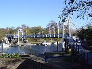
The Teddington Lock Footbridges are two footbridges over the River Thames in England, situated just upstream of Teddington Lock at Teddington. There is a small island between the bridges.
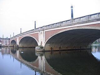
Hampton Court Bridge is a Grade II listed bridge that crosses the River Thames in England approximately north–south between Hampton, London and East Molesey, Surrey, carrying the A309. It is the upper of two road bridges on the reach above Teddington Lock and downstream of Molesey Lock.

Rivermead Island is a flat grassy island in the River Thames on the reach above Molesey Lock at Sunbury-on-Thames, Surrey, England which is owned mostly by Spelthorne and as to a small part by Elmbridge Borough Council.

Three river islands (aits) form a linear group, close to the junction of the two main old streets of Thames Ditton village, in the River Thames in a corner of modern Surrey, on the Kingston reach above Teddington Lock. Thames Ditton Island, the dominant ait, is 350 yards (320 m) long and has 48 houses with gardens ; Boyle Farm Island has one house; Swan Island, between the two, is the smallest.

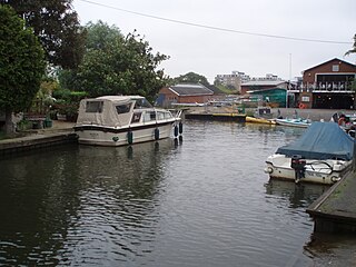
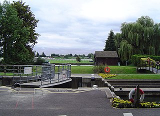
Molesey Lock is a lock on the River Thames in England at East Molesey, Surrey on the right bank.
Penton Hook Lock is the sixth lowest lock of forty four on the non-tidal reaches of the River Thames in England. It faces an island which was until its construction a pronounced meander and is on the site of its seasonal cutoff. It is against the left bank marking the church parish medieval border of Laleham and Staines upon Thames in Surrey for many centuries. Until 1965 their county was Middlesex. At 266 ft (81 m) it is the third longest lock on the river.
Boveney Lock is a lock on the River Thames situated on the Buckinghamshire bank opposite the Windsor Racecourse and close to Eton Wick. Boveney is a village a little way upstream on the same side. The lock was first built in 1838 by the Thames Navigation Commission. The lock was rebuilt in 1898 closer to the Buckinghamshire bank, and a set of boat rollers were installed on the old site.

Tagg's Island is an ait (island) on the River Thames on the reach above Molesey Lock and just above Ash Island, located in the London Borough of Richmond upon Thames and part of Hampton. The island is roughly 400 metres long by 90 metres wide at its widest point, covering 6 acres. Although close to the Surrey bank near East Molesey, the island is connected to the further Middlesex bank by a single track road bridge, being the only island on the non-tidal Thames accessible by car.

Garrick's Ait, previously known as Shank's Eyot, is an ait in the River Thames in England on the reach above Molesey Lock, the nearest land being Moulsey Hurst (park) on the Surrey bank and the opposite bank being a much narrower riverside park of Hampton. It is the only island in the United Kingdom named after an actor.

Sunbury Court Island is a long, pedestrianised residential island of houses and bungalows in the River Thames in England on the 'Sunbury and Hampton' or 'Molesey' reach, above Molesey Lock in Sunbury-on-Thames, Surrey, England.
Grand Junction Isle is a small island in the River Thames on the reach above Molesey Lock at Sunbury-on-Thames, Surrey, England. It is just downstream of Sunbury Court Island, which is three times longer and also close to the north bank.

Hampton Ferry is a seasonal foot ferry across the Thames in England. It is about 1 mile (1.6 km) upstream, west, of Hampton Court Bridge. The bridge links a busy zone of activity on both banks including Hampton Court Palace. The ferry links a large riverside park to the oldest parts of the town of Hampton, London, including its church, inn and various listed buildings such as Garrick House which is private apartments and Garrick's Temple to Shakespeare beside a narrow strip of sloped bank. This is known as Saint Albans Riverside, as it was owned by one of the Dukes of Saint Albans, seated at Hanworth House and Park, about two miles away. On the north side, this part of former Middlesex became outer-most London in 1965 by an Act of 1963. The towpath on the south side is for about 400 metres each way in public grassland with picnic places and beyond, for about 1 mile (1.6 km) shaded by trees, east and west.

Benn's Island, previously named Church Eyot, Kember's Eyot and sometimes referred to as Benn's Ait, is a private 0.1-acre (0.040 ha) ait (island) on the River Thames south-west of London. It is among a string of narrow islands above Molesey Lock and due to its clubhouse and size — the second-smallest named island on the Thames — it has deep foundation pilings to raise the building more than 1 m above the water line.

