Assumption, Illinois

Last updated

Assumption, Illinois
Image The Illinois State Bank Building.jpeg
The Illinois State Bank Building located at 201 N. Chestnut St.
Christian County Illinois Incorporated and Unincorporated areas Assumption Highlighted.svg
Location of Assumption in Christian County, Illinois.
Illinois in United States (US48).svg
Location of Illinois in the United States
Coordinates: 39°31′05″N89°02′52″W / 39.51806°N 89.04778°W / 39.51806; -89.04778 [1]
CountryUnited States
StateIllinois
County Christian
Government
  MayorDerek Page
Area
[2]
  Total0.99 sq mi (2.56 km2)
  Land0.99 sq mi (2.56 km2)
  Water0.00 sq mi (0.00 km2)
Elevation
[1]
640 ft (200 m)
Population
 (2020)
  Total1,155
  Density1,166.67/sq mi (450.42/km2)
Time zone UTC-6 (CST)
  Summer (DST) UTC-5 (CDT)
ZIP Code(s)
62510
Area code(s) 217. 447
FIPS code 17-02609
GNIS ID2394007 [1]
Wikimedia CommonsAssumption, Illinois
Website cityofassumption.org

Assumption is a city in Christian County, Illinois, United States. The population was 1,155 as of the 2020 census.

Contents

History

Illinois Central Railroad depot in Assumption, 1913 Assumption, Illinois (1913).jpg
Illinois Central Railroad depot in Assumption, 1913

Assumption originally was called "Tacusah". [3] The present name is after Assumption Parish, Louisiana. [4] A post office called Assumption has been in operation since 1858. [5] Assumption lays claim to the deepest coal mine (abandoned in the 1930s) in the state at over 1000' below the surface. First National Bank of Assumption (founded in 1900) claims to be the oldest bank in Christian County as it was the only bank in the county to remain open during the Great Depression.

In May 2017, news reached Assumption of the recovery of the remains of United States Air Force Captain Joseph S. Smith, a pilot shot down over Cambodia in 1971 during the Vietnam War. A large portion of the community turned out for his repatriation and interment in July 2017.

Geography

According to the 2020 census, Assumption has a total area of 0.88 square miles (2.28 km2), all land. [6]

Demographics

Historical population
CensusPop.Note
1870 590
1880 70619.7%
1890 1,07652.4%
1900 1,70258.2%
1910 1,91812.7%
1920 1,852−3.4%
1930 1,554−16.1%
1940 1,5610.5%
1950 1,466−6.1%
1960 1,439−1.8%
1970 1,4873.3%
1980 1,283−13.7%
1990 1,244−3.0%
2000 1,2611.4%
2010 1,168−7.4%
2020 1,155−1.1%
U.S. Decennial Census [7]

As of the 2020 census [8] there were 1,155 people, 514 households, and 262 families residing in the city. The population density was 1,166.67 inhabitants per square mile (450.45/km2). There were 576 housing units at an average density of 581.82 per square mile (224.64/km2). The racial makeup of the city was 94.20% White, 0.52% African American, 0.00% Native American, 0.17% Asian, 0.00% Pacific Islander, 0.26% from other races, and 4.85% from two or more races. Hispanic or Latino of any race were 1.99% of the population.

There were 514 households, out of which 29.8% had children under the age of 18 living with them, 34.63% were married couples living together, 12.45% had a female householder with no husband present, and 49.03% were non-families. 30.54% of all households were made up of individuals, and 9.53% had someone living alone who was 65 years of age or older. The average household size was 2.92 and the average family size was 2.24.

The city's age distribution consisted of 19.9% under the age of 18, 19.8% from 18 to 24, 20.4% from 25 to 44, 25% from 45 to 64, and 14.7% who were 65 years of age or older. The median age was 37.2 years. For every 100 females, there were 109.6 males. For every 100 females age 18 and over, there were 107.9 males.

The median income for a household in the city was $46,563, and the median income for a family was $57,083. Males had a median income of $32,692 versus $20,761 for females. The per capita income for the city was $24,281. About 12.6% of families and 10.3% of the population were below the poverty line, including 13.8% of those under age 18 and 13.5% of those age 65 or over.

Education

Until 1992, Assumption was served by the Assumption School District #9. Since 1992, Assumption has been served by the Central A&M School District, [9] which also includes the village of Moweaqua, as well as the nearby rural areas. Central A&M Middle School (grades 6-8) and Bond Elementary School (preK-2) are located in Assumption, as well as the school district office. [10] [11]

Enrollment at the middle school is approximately 170 students.

Assumption is also home to Kemmerer Village, a private Presbyterian childcare agency, named for donor Philip Kemmerer who willed 400 acres (1.6 km2) to "the orphans and friendless poor of all denominations" in 1884. Originally known as Kemmerer Orphan Home, the facility opened in 1914. In 1930, the named was changed to Kemmerer Children's Home. Eventually the name became Kemmerer Village. [12] [13]

Notable people

Related Research Articles

<span class="mw-page-title-main">Lincoln County, Wyoming</span> County in Wyoming, United States

Lincoln County is a county in the U.S. state of Wyoming. As of the 2020 United States Census, the population was 19,581. Its county seat is Kemmerer. Its western border abuts the eastern borders of the states of Idaho and Utah.

<span class="mw-page-title-main">Panama, Illinois</span> Village in Illinois, United States

Panama is a village in Montgomery and Bond counties, Illinois, United States. The population was 337 at the 2020 census.

<span class="mw-page-title-main">Ladd, Illinois</span> Village in Illinois, United States

Ladd is a village in Bureau County, Illinois, United States. The population was 1,236 at the 2020 census. It is part of the Ottawa Micropolitan Statistical Area. Ladd is perhaps most known for a Vietnam War tank located in the center of its park.

<span class="mw-page-title-main">Fisher, Illinois</span> Village in Illinois, United States

Fisher is a village in Champaign County, Illinois, United States, that was founded in 1875. The population was 1,881 at the 2010 census.

<span class="mw-page-title-main">Moweaqua, Illinois</span> Village in Illinois, United States

Moweaqua is a village in Shelby and Christian counties, Illinois, United States. The population was 1,764 at the 2020 census.

<span class="mw-page-title-main">Beckemeyer, Illinois</span> Village in Illinois, United States

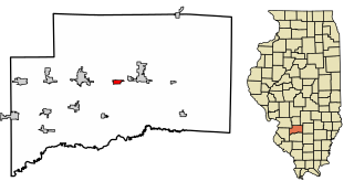
Beckemeyer is a village in Wade Township, Clinton County, Illinois, United States. The population was 923 as of the 2020 census.

<span class="mw-page-title-main">Breese, Illinois</span> City in Illinois, United States

Breese is a city in Clinton County, Illinois, United States. Breese is the most populous city completely within Clinton County. As of the 2020 census, the population was 4,641, the majority of whom are of German ancestry. Breese is part of the Metro-East region of the Greater St. Louis metropolitan area.

<span class="mw-page-title-main">Hoffman Estates, Illinois</span> Village in Illinois, United States

Hoffman Estates is a village in Cook County, Illinois, United States. It is a suburb of Chicago. Per the 2020 census, the population was 52,530.

<span class="mw-page-title-main">West City, Illinois</span> Village in Illinois, United States

West City is a village in Franklin County, Illinois, adjacent to the county seat of Benton. The population was 656 at the 2020 census.

<span class="mw-page-title-main">New Haven, Illinois</span> Village in Illinois, United States

New Haven is a village in Gallatin County, Illinois, United States, along the Little Wabash River near its mouth at the Wabash River. The population was 399 at the 2020 United States Census, down from 433 at the 2010 United States Census.

<span class="mw-page-title-main">Coal City, Illinois</span> Village in Illinois, United States

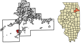
Coal City is a village in Grundy and Will Counties in the U.S. state of Illinois. It is considered a fringe town of the Chicago metropolitan area. The population was 5,705 at the 2020 census.

<span class="mw-page-title-main">Buckingham, Illinois</span> Village in Illinois, United States

Buckingham is a village in Kankakee County, Illinois, United States. The population was 300 at the 2010 census, up from 237 at the 2000 census. The village is about 63.7 miles south west of Chicago Illinois. It is included in the Kankakee-Bradley, Illinois Metropolitan Statistical Area.

<span class="mw-page-title-main">Oglesby, Illinois</span> City in Illinois, United States

Oglesby is a city in LaSalle County, Illinois, United States. The population was 3,712 at the 2020 census, down from 3,791 at the 2010 census. It is part of the Ottawa Micropolitan Statistical Area.

<span class="mw-page-title-main">Mount Pulaski, Illinois</span> City in Illinois, United States

Mount Pulaski is a city in Logan County, Illinois, United States. The population was 1,566 at the 2010 census, and 1,481 at a 2018 estimate. It is the home of the Mount Pulaski Courthouse State Historic Site. The city is named in honor of Polish Revolutionary War hero Casimir Pulaski. Mount Pulaski has one high school: Mount Pulaski High School, home of the Hilltoppers. The school colors are purple and gold. Mount Pulaski held the county seat of Logan County from 1848 to 1855.

<span class="mw-page-title-main">Viola, Illinois</span> Village in Illinois, United States

Viola is a village in Mercer County, Illinois, United States. The population was 869 at the 2020 census, a decline of 9 percent from 955 in 2010.

<span class="mw-page-title-main">Fairview Heights, Illinois</span> City in Illinois, United States

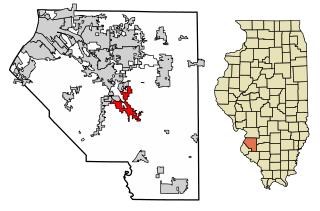
Fairview Heights is a city in St. Clair County, Illinois, United States within Greater St. Louis. It is an eastern suburb of St. Louis. The population was 17,078 at the 2010 census. Fairview Heights is a dominant shopping center for Greater St. Louis and Southern Illinois and includes numerous shopping plazas and St. Clair Square mall.

<span class="mw-page-title-main">Freeburg, Illinois</span> Village in Illinois, United States

Freeburg is a village in St. Clair County, Illinois, United States. Located within Greater St. Louis, it is a southeastern exurb with many residents commuting to Downtown St. Louis or the Belleville area for employment. As of 2010, Freeburg had a population of 4,354.

<span class="mw-page-title-main">Millstadt, Illinois</span> Village in Illinois, United States

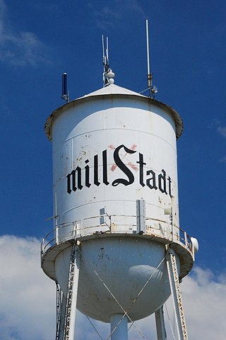
Millstadt is a village in St. Clair County, Illinois, United States, located at the crossing of Illinois Routes 163 and 158. The village is known for its German heritage, with more than half its people of German descent. The population was 4,011 at the 2010 census, but a more recent study in July 2018 estimated the number at 3,885.

<span class="mw-page-title-main">Minonk, Illinois</span> City in Illinois, United States

Minonk is a city in Minonk Township, Woodford County, Illinois. The population was 2,078 at the 2010 census, down from 2,168 in 2000. The city is part of the Peoria, Illinois, metropolitan area.

<span class="mw-page-title-main">Kemmerer, Wyoming</span> City in Wyoming, United States

Kemmerer is the largest city in and the county seat of Lincoln County, Wyoming, United States. Its population was 2,415 at the 2020 census.

References

  1. 1 2 3 U.S. Geological Survey Geographic Names Information System: Assumption, Illinois
  2. "2020 U.S. Gazetteer Files". United States Census Bureau. Retrieved March 15, 2022.
  3. Illinois Central Magazine. Illinois Central Railroad Company. 1922. p. 44.
  4. "Our History". City of Assumption. Retrieved October 18, 2022.
  5. "Post Offices". Jim Forte Postal History. Retrieved February 20, 2018.
  6. "G001 - Geographic Identifiers - 2010 Census Summary File 1". United States Census Bureau. Archived from the original on February 13, 2020. Retrieved December 25, 2015.
  7. "Census of Population and Housing". Census.gov. Retrieved June 4, 2015.
  8. "Explore Census Data". data.census.gov. Retrieved June 28, 2022.
  9. "Central A&M; Community Unit District #21". www.cam.k12.il.us. Archived from the original on June 30, 2007. Retrieved January 12, 2022.
  10. "Central A & M Middle School". www.cam.k12.il.us. Archived from the original on June 15, 2007. Retrieved January 12, 2022.
  11. "Bond Elementary School". www.cam.k12.il.us. Archived from the original on July 2, 2007. Retrieved January 12, 2022.
  12. "Kemmerer Village - History". Archived from the original on June 26, 2013. Retrieved July 6, 2013.
  13. "Kemmerer Village". www.cam.k12.il.us. Archived from the original on June 15, 2007. Retrieved January 12, 2022.