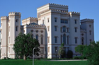
Baton Rouge is the capital city of the U.S. state of Louisiana. Located on the eastern bank of the Mississippi River, it had a population of 227,470 as of 2020; it is the seat of Louisiana's most populous parish (county-equivalent), East Baton Rouge Parish, and the center of Louisiana's second-largest metropolitan area, Greater Baton Rouge.
West Baton Rouge Parish is one of the sixty-four parishes in the U.S. state of Louisiana. Established in 1807, its parish seat is Port Allen. With a 2020 census population of 27,199 residents, West Baton Rouge Parish is part of the Baton Rouge metropolitan statistical area.

St. Landry Parish is a parish located in the U.S. state of Louisiana. As of the 2020 Census, the population was 82,540. The parish seat is Opelousas. The parish was established in 1807.

Iberville Parish is a parish located south of Baton Rouge in the U.S. state of Louisiana, formed in 1807. The parish seat is Plaquemine. The population was 30,241 at the 2020 census.

Acadiana, also known as the Cajun Country, is the official name given to the French Louisiana region that has historically contained much of the state's Francophone population.

The Atchafalaya River is a 137-mile-long (220 km) distributary of the Mississippi River and Red River in south central Louisiana in the United States. It flows south, just west of the Mississippi River, and is the fifth largest river in North America, by discharge. The name Atchafalaya comes from Choctaw for 'long river', from hachcha, 'river', and falaya, 'long'.

Interstate 10 (I-10), a major transcontinental Interstate Highway in the Southern United States, runs across the southern part of Louisiana for 274.42 miles (441.64 km) from Texas to Mississippi. It passes through Lake Charles, Lafayette, and Baton Rouge, dips south of Lake Pontchartrain to serve the New Orleans metropolitan area, then crosses Lake Pontchartrain and leaves the state.

Louisiana Highway 14 (LA 14) is a state highway located in southern Louisiana. It runs 100.10 miles (161.10 km) in an east–west direction from the junction of U.S. Highways 90 and 171 in Lake Charles to LA 182 in New Iberia.

The Plaquemine culture was an archaeological culture centered on the Lower Mississippi River valley. It had a deep history in the area stretching back through the earlier Coles Creek and Troyville cultures to the Marksville culture. The Natchez and related Taensa peoples were their historic period descendants. The type site for the culture is the Medora site in Louisiana; while other examples include the Anna, Emerald, Holly Bluff, and Winterville sites in Mississippi.

William Harold Nungesser is an American politician serving as the 54th lieutenant governor of Louisiana since 2016. A member of the Republican Party, Nungesser is also the former president of the Plaquemines Parish Commission, having been re-elected to a second four-year term in the 2010 general election in which he topped two opponents with more than 71 percent of the vote. His second term as parish president began on January 1, 2011, and ended four years later.

The Louisiana Circuit Courts of Appeal are the intermediate appellate courts for the state of Louisiana.
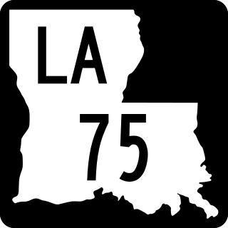
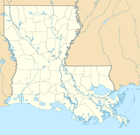
Louisiana Highway 75 (LA 75) is a state highway located in southeastern Louisiana. It runs 46.86 miles (75.41 km) in a general east–west direction from a dead end in Bayou Pigeon to the junction of LA 22 and LA 942 in Darrow.
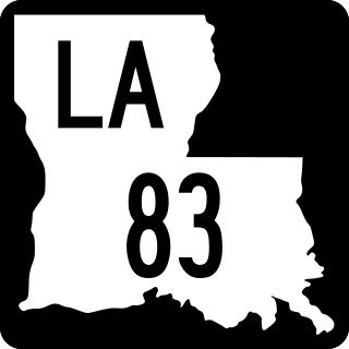
Louisiana Highway 83 (LA 83) is a state highway located in southern Louisiana. It runs 34.01 miles (54.73 km) in a general east–west direction from LA 14 in New Iberia to LA 182 in Baldwin.

Louisiana Highway 87 (LA 87) is a state highway located in southern Louisiana. It runs 42.04 miles (67.66 km) in a northwest to southeast direction from LA 86 in New Iberia to the junction of two local roads north of Centerville.

Louisiana Highway 96 (LA 96) is a state highway located in southern Louisiana. It runs 19.54 miles (31.45 km) in an east–west direction from LA 182 in Broussard to LA 352 east of Catahoula.

James Morgan Field, known as Jimmy Field, is a part-time attorney in Baton Rouge, Louisiana, and a Republican former member of the Louisiana Public Service Commission. The five-member public regulatory agency oversees utilities, trucking, and telecommunications companies. Field was elected to the PSC in 1996 to succeed the Democrat Kathleen Babineaux Blanco of Lafayette, who became lieutenant governor and subsequently governor from 2004 to 2008.

The National Weather Service Weather Forecast Office New Orleans/Baton Rouge, Louisiana is a National Weather Service office located in Slidell, Louisiana.
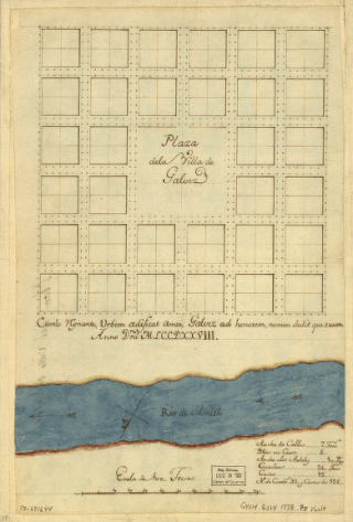
Galveztown, or Villa de Gálvez, is a ghost town located at the confluence of Bayou Manchac and the Amite River in Ascension Parish, Louisiana. Galveztown was established in 1778 with the settlement of Canary Islanders colonists and Anglo-Americans fleeing the American Revolutionary War. Due to deplorable conditions and disease, the settlement was eventually abandoned and many residents fled to Spanish Town in 1806. Some former residents remained in the area and established the community of Gálvez, Louisiana during the first half of the nineteenth century.