Related Research Articles

McPherson Square is a Washington Metro station in Downtown, Washington, D.C., United States. The side-platformed station is operated by the Washington Metropolitan Area Transit Authority (WMATA). Providing service for the Blue, Silver, and Orange Lines, the station is located between McPherson Square and Franklin Square, with two entrances on I Street at Vermont Avenue and 14th Street NW. This is the main station to access the White House, and the Vermont Avenue exit is directly underneath the Department of Veterans Affairs building.

Swampoodle was a neighborhood in Washington, D.C. on the border of Northwest and Northeast in the second half of 19th and early 20th century. This neighborhood is no longer known as Swampoodle and has been replaced in large part by NoMa.

Swampoodle Grounds aka Capitol Park (II) was the home of the Washington Nationals baseball team of the National League from 1886 to 1889. The name refers to the one-time Swampoodle neighborhood of Washington.
Boundary Field, also known as American League Park II and National Park, is a former baseball ground in Washington, D.C. located on the site currently occupied by Howard University Hospital; bounded approximately by Georgia Avenue, 5th Street, W Street and Florida Avenue, NW. It was just outside what was then the city limit of Washington, whose northern boundary was Boundary Street which was renamed Florida Avenue in 1890.
Olympics Grounds was a baseball grounds located in Washington, D.C. It was home to the Washington Olympics of the National Association in 1871–1872 and home to the short-lived Washington clubs of 1873 and 1875, including the Washington Blue Legs. It is considered a major league ballpark by those who count the NA as a major league.
Pentagon City is an unincorporated neighborhood located in the southeast portion of Arlington County, Virginia, near The Pentagon and Arlington National Cemetery.
The Washington meridians are four meridians that were used as prime meridians in the United States and pass through Washington, D.C. The four which have been specified are:
- through the Capitol
- through the White House
- through the old Naval Observatory
- through the new Naval Observatory.
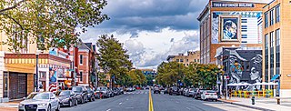
The U Street Corridor, sometimes called Cardozo/Shaw or Cardozo, is a commercial and residential district in Northwest Washington, D.C., most of which also constitutes the Greater U Street Historic District. It is centered along a nine-block stretch of U Street from 9th to 18th Streets, which from the 1920s until the 1960s was the city's black entertainment hub, called "Black Broadway" and "the heart of black culture in Washington, D.C.". After a period of decline following the 1968 riots, the economy picked up with the 1991 opening of the U Street Metro station. Subsequent gentrification diversified the population, which is 67% non-Hispanic White and 18% African American. Since 2013, thousands of residents have moved into new luxury apartment buildings. U Street is now promoted as a "happening" neighborhood for upscale, "hip", and "eclectic" dining and shopping, its live music and nightlife, as well as one of the most significant African American heritage districts in the country.

Freedom Plaza, originally known as Western Plaza, is an open plaza in Northwest Washington, D.C., United States, located near 14th Street and Pennsylvania Avenue NW, adjacent to Pershing Park. The plaza features an inlay that partially depicts Pierre (Peter) Charles L'Enfant's plan for the City of Washington. The National Park Service administers the Plaza as part of its Pennsylvania Avenue National Historic Site and coordinates the Plaza's activities.
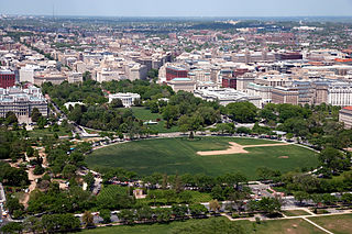
The Ellipse is a 52-acre (21 ha) park south of the White House fence and north of Constitution Avenue and the National Mall in Washington, D.C. The Ellipse is also the name of the five-furlong (1.0 km) circumference street within the park. The entire park, which features monuments, is open to the public and is part of President's Park. The Ellipse is the location for many annual events.

Jefferson Pier, Jefferson Stone, or the Jefferson Pier Stone, in Washington, D.C., marks the second prime meridian of the United States even though it was never officially recognized, either by presidential proclamation or by a resolution or act of Congress.
Sherman Circle is an urban park and traffic circle in the Northwest Washington, D.C. neighborhood of Petworth at the intersection of Illinois Avenue, Kansas Avenue, 7th Street, and Crittenden Street NW. The circle is named in honor of Civil War general William Tecumseh Sherman. Administered by the National Park Service's Rock Creek Park unit, Sherman Circle together with four surrounding triangular parks covers 3.44 acres (1.39 ha) and is considered by the National Park Service a "cultural landscape."
The Capitol Groundsa.k.a.Capitol Park (I), was a baseball field in Washington, D.C. The grounds were the home field for the Washington Nationals of the Union Association during the league's only season in 1884. The ballpark had a seating capacity of 6,000, and was where the Russell Senate Office Building stands today.

Navy Yard, also known as Near Southeast, is a neighborhood on the Anacostia River in Southeast Washington, D.C. Navy Yard is bounded by Interstate 695 to the north and east, South Capitol Street to the west, and the Anacostia River to the south. Approximately half of its area is occupied by the Washington Navy Yard, which gives the neighborhood its name. The neighborhood is located in D.C.'s Ward 6, currently represented by Charles Allen. It is served by the Navy Yard – Ballpark Metro station on the Green Line.
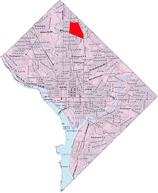
Manor Park is a neighborhood in Ward 4 of northwest Washington, D.C. The National Capital Planning Commission 1967 "District Communities" map indicates this neighborhood is roughly bounded between 8th Street NW to the west, North Capitol Street NW, Blair Road NW, and the Washington Metropolitan Area Red Line train tracks to the east, Rittenhouse Street NW to the north, and Missouri Avenue NW to the south. Manor Park borders the adjacent neighborhoods of Takoma Park, Brightwood, and Brightwood Park in NW Washington D.C. and also borders the Riggs Park neighborhood in NE Washington D.C. In 1940, the Manor Park Citizens Association deemed the boundaries to be Eighth Street, Whittier Street, North Capitol Street, and Concord Street.

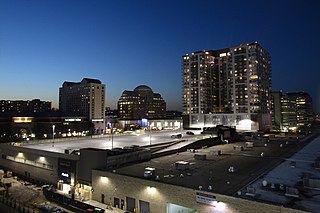
Downtown is the central business district located in the northwest quadrant of Washington, D.C. It is the fourth largest central business district in the United States. The "Traditional Downtown" has been defined as an area roughly between Union Station in the east and 16th Street NW in the west, and between the National Mall on the south and Massachusetts Avenue on the north, including Penn Quarter. However, nowadays, Downtown D.C. usually refers to a larger area, as the DC Office of Planning states:
…most residents, workers, and visitors think of Downtown in a broader sense — including areas as far north as Dupont Circle, as far west as Foggy Bottom, and as far east as Capitol Hill. Only about half of the central city workforce is located within the city’s traditional Downtown.
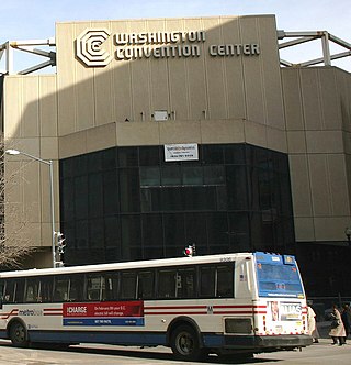
The Washington Convention Center in Washington, D.C. was a convention center located one block southwest at 909 H Street NW, occupying the city block bounded by New York Avenue, 9th Street, H Street, and 11th Street. Construction on the center began in 1980, and it opened on December 10, 1982. At 800,000 square feet (74,000 m2), it was the fourth largest facility in the United States at the time. However, during the 1980s and 1990s, numerous larger and more modern facilities were constructed around the country, and by 1997 the Washington Convention Center had become the 30th largest facility.
Tinker Park is the name of a former baseball ground located in Indianapolis, Indiana. The ground was the primary home of the Indianapolis Hoosiers baseball club of the National League from 1887 to 1889, and also of the Indianapolis Blues of the American Association in 1884.
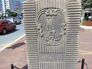
The Garden Club of America Entrance Markers in Washington, D.C. is a Multiple Property Submission, or MPS, on the National Register of Historic Places. The seven structures that make up the MPS are ceremonial markers at important entrance points to the District of Columbia from the state of Maryland. Sets of two markers are located in Westmoreland Circle, Friendship Heights and Chevy Chase Circle. A single marker is located along Georgia Avenue.
References
- ↑ "Washington Statesmen Attendance, Stadiums, and Park Factors". Baseball-Reference.com . Archived from the original on November 29, 2010. Retrieved December 7, 2009.
Coordinates: 38°54′53.2″N77°1′27.7″W / 38.914778°N 77.024361°W