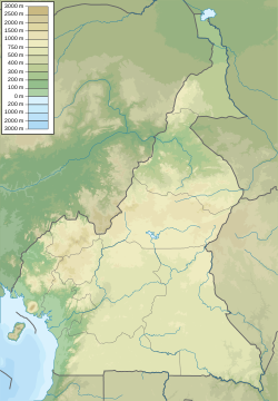
At 475,440 km2 (183,570 sq mi), Cameroon is the world's 53rd largest country. It is slightly larger than the nation of Sweden and the US state of California. It is comparable in size to Papua New Guinea. Cameroon's landmass is 472,710 km2 (182,510 sq mi), with 2,730 km2 (1,050 sq mi) of water.
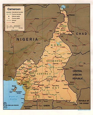
Nigeria is a country in West Africa. It shares land borders with the Republic of Benin to the west, Chad and Cameroon to the east, and Niger to the north. Its coast lies on the Gulf of Guinea in the south and it borders Lake Chad to the northeast. Notable geographical features in Nigeria include the Adamawa Plateau, Mambilla Plateau, Jos Plateau, Obudu Plateau, the Niger River, Benue River, and Niger Delta.

Adamawa state is a state in the North-East geopolitical zone of Nigeria, bordered by Borno to the northwest, Gombe to the west, and Taraba to the southwest, while its eastern border forms part of the national border with Cameroon. It takes its name from the historic emirate of Adamawa, with the emirate's old capital of Yola, serving as the capital city of Adamawa state. The state is one of the most heterogeneous in Nigeria, with over 100 indigenous ethnic groups. It was formed in 1991, when the former Gongola state was divided into Adamawa and Taraba states. Since it was carved out of the old Gongola State in 1991 by the General Ibrahim Badamsi Babangida military regime, Adamawa State has had 10 men, both military and civilian, controlling the levers of power, who played crucial roles in transforming the state into what it is today.
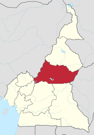
The Adamawa Region is a constituent region of the Republic of Cameroon. It borders the Centre and East regions to the south, the Northwest and West regions to the southwest, Nigeria to the west, the Central African Republic (CAR) to the east, and the North Region to the north.

The Adamawa Plateau is a plateau region in west-central Africa stretching from south-eastern Nigeria through north-central Cameroon to the Central African Republic. The part of the plateau that lies in Nigeria is more popularly known as Gotel Mountains.

The North Region makes up 66,090 km2 of the northern half of The Republic of Cameroon. Neighbouring territories include the Far North Region to the north, the Adamawa Region to the south, Nigeria to the west, Chad to the east, and Central African Republic to the southeast. The city of Garoua is both the political and industrial capital. Garoua is Cameroon's third largest port, despite the fact that the Bénoué River upon which it relies is only navigable for short periods of the year.

The Mandara Mountains are a volcanic range extending about 190 km along the northern part of the Cameroon–Nigeria border, from the Benue River in the south to the north-west of Maroua in the north. The highest elevation is the summit of Mount Oupay, at 1,494 m (4,900 ft) above sea level.
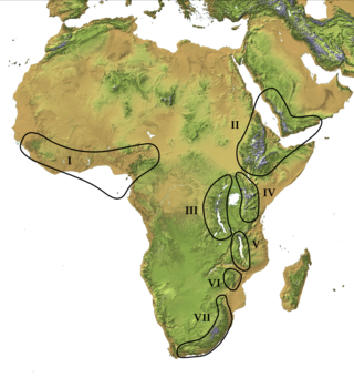
The Afromontane regions are subregions of the Afrotropical realm, one of the Earth's eight biogeographic realms, covering the plant and animal species found in the mountains of Africa and the southern Arabian Peninsula. The Afromontane regions of Africa are discontinuous, separated from each other by lower-lying areas, and are sometimes referred to as the Afromontane archipelago, as their distribution is analogous to a series of sky islands.

The Cameroon line is a 1,600 km (1,000 mi) long chain of volcanoes that includes islands in the Gulf of Guinea and mountains on the African mainland, from Mount Cameroon on the coast towards Lake Chad on the northeast. They form a natural border between eastern Nigeria and the West Region of Cameroon. The islands, which span the equator, have tropical climates and are home to many unique plant and bird species. The mainland mountain regions are much cooler than the surrounding lowlands, and also contain unique and ecologically important environments.

The Cameroonian Highlands forests, also known as the Cameroon Highlands forests, are a montane tropical moist broadleaf forest ecoregion located on the range of mountains that runs inland from the Gulf of Guinea and forms the border between Cameroon and Nigeria. This is an area of forest and grassland which has become more populous as land is cleared for agriculture.

The wildlife of Cameroon is composed of its flora and fauna. Bordering Nigeria, it is considered one of the wettest parts of Africa and records Africa's second highest concentration of biodiversity. To preserve its wildlife, Cameroon has more than 20 protected reserves comprising national parks, zoos, forest reserves and sanctuaries. The protected areas were first created in the northern region under the colonial administration in 1932; the first two reserves established were Mozogo Gokoro Reserve and the Bénoué Reserve, which was followed by the Waza Reserve on 24 March 1934. The coverage of reserves was initially about 4 percent of the country's area, rising to 12 percent; the administration proposes to cover 30 percent of the land area.

The Western High Plateau, Western Highlands or Bamenda Grassfields is a region of Cameroon characterised by high relief, cool temperatures, heavy rainfall and savanna vegetation. The region lies along the Cameroon line and consists of mountain ranges and volcanoes made of crystalline and igneous rock. The region borders the South Cameroon Plateau to the southeast, the Adamawa Plateau to the northeast and the Cameroon coastal plain to the south.
Gashaka-Gumti National Park (GGNP) is a national park in Nigeria, It was gazetted from two game reserves in 1991 and is Nigeria's largest national park. It is located in the eastern provinces of Taraba and Adamawa to the border with Cameroon. The total area covers about 6,402 km2, much of the northern GGNP is savannah grassland, while the southern GGNP sector of the park has a rugged terrain characterized by very mountainous, steep slopes as well as deep valleys and gorges, and is home to montane forests. Altitude ranges from ranging from about 457 metres (1,499 ft) in the northern flatter corner of the park, up to 2,419 metres (7,936 ft) at Chappal Waddi, Nigeria's highest mountain in the park's southern sections. It is an important water catchment area for the Benue River. There is abundant river flow even during the markedly dry season. Enclaves for local Fulani pastoralists exist within the park boundary that allow for farming and grazing.
The 'Ngel Nyaki Forest Reserve, whose site is historically known as Majang, is situated on the Mambilla Plateau in North East Nigeria, covering 46 km2. It can be reached on foot from Yelwa village past the Mayo Jigawal, from where it is less than half an hour’s walk to the upper edge of the forest. The altitude ranges from 1,400 metres (4,593 ft) to 1,600 metres (5,249 ft). Ngel Nyaki was formally gazetted a local authority Forest Reserve under Gashaka - Mambilla Native Authority Forest order of April 1969, but presently it is under the management of the Taraba State Government and the Nigerian Conservation Foundation (NCF), with the Nigerian Montane Forest Project (NMFP) as a project partner.

Mount Oku, or Kilum Mountain, is the largest volcano in the Oku Massif, in the Cameroon Volcanic Line, located in the Oku region of the Western High Plateau of Cameroon. It is the second highest mountain in mainland Central Africa. The stratovolcano rises to 3,011 metres (9,879 ft) above sea level, and is cut by a large caldera.

The East African montane forests is a montane tropical moist forest ecoregion of eastern Africa. The ecoregion comprises several separate areas above 2000 meters in the mountains of South Sudan, Uganda, Kenya, and Tanzania.
The Gwèri or Vere language Were also known as Kobo or Mom Jango, is a member of the Duru branch of Savanna languages. It is spoken across the northern Nigerian–Cameroonian border.
The Koma language is a language cluster belonging to the Duru branch of Savannas languages of Cameroon. Blench (2004) includes three varieties separated in Ethnologue, Koma Ndera, Gɨmne, and Gɨmnɨme; within Koma Ndera, speakers of the marginal dialects, Gomnome and Ndera, can scarcely understand one another, though both understand the central dialect, Gomme.
Koma is a relatively primitive hill-dwelling ethnic group in northern Adamawa, in the Atlantika Mountains, which shares a border with southern Cameroun. Hill-dwellers are spread through the south and southwest of these mountains, including many on the Cameroun side. There are 21 Koma villages in the Cameroonian side of the Alantika Mountains and 17 villages on the Nigerian side.

The Mandara Plateau mosaic, also known as the Mandara Plateau woodlands, is a tropical grasslands, savannas, and shrublands ecoregion located in the Mandara Mountains of northern Nigeria and Cameroon.