Aurora, Indiana

Last updated

Aurora, Indiana
Aurora, Indiana.jpg
Aurora, Indiana logo.gif
Nickname: 
City of Spires
Dearborn County Indiana Incorporated and Unincorporated areas Aurora Highlighted 1802782.svg
Location of Aurora in Dearborn County, Indiana.
Coordinates: 39°04′12″N84°53′43″W / 39.07000°N 84.89528°W / 39.07000; -84.89528
Country United States
State Indiana
County Dearborn
Township Center
Platted1819
Incorporated1848
Government
   Mayor Mark A. Drury (R)
Area
[1]
  Total3.54 sq mi (9.16 km2)
  Land3.29 sq mi (8.53 km2)
  Water0.24 sq mi (0.63 km2)
Elevation
[2]
515 ft (157 m)
Population
 (2020)
  Total3,479
  Density1,056.80/sq mi (408.05/km2)
Time zone UTC-5 (EST)
  Summer (DST) UTC-4 (EDT)
ZIP code
47001
Area code 812
FIPS code 18-02782
GNIS ID2394030 [2]
Website www.aurora.in.us

Aurora is a city in Center Township, Dearborn County, Indiana, United States. The population was 3,750 at the 2010 census.

Contents

Geography

According to the 2010 census, Aurora has a total area of 3.087 square miles (8.00 km2), of which 2.76 square miles (7.15 km2) (or 89.41%) is land and 0.327 square miles (0.85 km2) (or 10.59%) is water. [3]

History

Aurora was platted in 1819. [4] It was named for Aurora, the goddess of dawn in Roman mythology. [5] Aurora was incorporated in 1848. [6]

Aurora is known for its historic downtown area and the ornate Hillforest mansion built for Thomas Gaff who earned his fortune shipping goods on the Ohio River by steamboat. [7] The mansion was designed by architect Isaiah Rogers and was completed in 1855 in the Italian Renaissance style. The design is symmetrical. Details include deep overhangs, arched windows and balconies and porches. Hillforest was declared a National Historic Landmark in 1992. [8]

In addition to Hillforest, the Aurora City Hall, Aurora Methodist Episcopal Church, Aurora Public Library, Downtown Aurora Historic District, First Evangelical United Church of Christ, First Presbyterian Church, George Street Bridge, Lewis Hurlbert, Sr. House, Leive, Parks and Stapp Opera House, Levi Stevens House, and George Sutton Medical Office are listed on the National Register of Historic Places. [9]

Demographics

Historical population
CensusPop.Note
1850 1,954
1860 2,99053.0%
1870 3,30410.5%
1880 4,43534.2%
1890 3,929−11.4%
1900 3,645−7.2%
1910 4,41021.0%
1920 4,299−2.5%
1930 4,3862.0%
1940 4,82810.1%
1950 4,780−1.0%
1960 4,119−13.8%
1970 4,2934.2%
1980 3,816−11.1%
1990 3,8250.2%
2000 3,9653.7%
2010 3,750−5.4%
2020 3,479−7.2%
U.S. Decennial Census [10]

2010 census

As of the 2010 census, [11] there were 3,750 people, 1,472 households, and 936 families living in the city. The population density was 1,358.7 inhabitants per square mile (524.6/km2). There were 1,647 housing units at an average density of 596.7 per square mile (230.4/km2). The racial makeup of the city was 97.5% White, 0.5% African American, 0.3% Native American, 0.3% Asian, 0.5% from other races, and 0.7% from two or more races. Hispanic or Latino of any race were 1.5% of the population.

There were 1,472 households, of which 35.1% had children under the age of 18 living with them, 42.3% were married couples living together, 15.1% had a female householder with no husband present, 6.1% had a male householder with no wife present, and 36.4% were non-families. 29.1% of all households were made up of individuals, and 11.6% had someone living alone who was 65 years of age or older. The average household size was 2.55 and the average family size was 3.11.

The median age in the city was 36.2 years. 26.6% of residents were under the age of 18; 8.7% were between the ages of 18 and 24; 26.5% were from 25 to 44; 25.3% were from 45 to 64; and 12.9% were 65 years of age or older. The gender makeup of the city was 49.3% male and 50.7% female.

2000 census

As of the 2000 census, [12] there were 3,965 people, 1,592 households, and 1,022 families living in the city. The population density was 1,428.2 inhabitants per square mile (551.4/km2). There were 1,716 housing units at an average density of 618.1 per square mile (238.6/km2). The racial makeup of the city was 98.59% White, 0.10% African American, 0.33% Native American, 0.15% Asian, 0.25% from other races, and 0.58% from two or more races. Hispanic or Latino of any race were 0.61% of the population.

Aurora from the air, looking northeast. Aurora-indiana-from-above.jpg
Aurora from the air, looking northeast.

There were 1,592 households, out of which 31.8% had children under the age of 18 living with them, 47.4% were married couples living together, 12.2% had a female householder with no husband present, and 35.8% were non-families. 29.7% of all households were made up of individuals, and 11.7% had someone living alone who was 65 years of age or older. The average household size was 2.48 and the average family size was 3.08.

In the city, the population was spread out, with 26.9% under the age of 18, 9.1% from 18 to 24, 30.7% from 25 to 44, 20.3% from 45 to 64, and 13.1% who were 65 years of age or older. The median age was 35 years. For every 100 females, there were 96.2 males. For every 100 females age 18 and over, there were 91.8 males.

The median income for a household in the city was $32,500, and the median income for a family was $39,331. Males had a median income of $32,058 versus $24,671 for females. The per capita income for the city was $16,587. About 9.4% of families and 10.4% of the population were below the poverty line, including 11.3% of those under age 18 and 12.3% of those age 65 or over.

Government

The government consists of a mayor and a city council. The mayor is elected in citywide vote. The city council consists of five members. Four are elected from individual districts. One is elected at-large.

Current elected officials

[13]

Timeline of 19th-century mayors

[4]

Aurora, Indiana

Education

The town has a free lending library, the Aurora Public Library District. [14]

Notable people

See also

Related Research Articles

<span class="mw-page-title-main">Alexandria, Indiana</span> City in Indiana, United States

Alexandria is a city in Monroe Township, Madison County, Indiana, United States. It is about 48 miles (77 km) northeast of Indianapolis. According to the 2020 census, its population was 5,149, nearly unchanged from 2010.

<span class="mw-page-title-main">Henry County, Indiana</span> County in Indiana, United States

Henry County is a county located in east central Indiana, United States. As of 2020, the population was 48,914. The county seat and largest and only city is New Castle. Henry County is the main setting of the novel Raintree County by Ross Lockridge Jr.

<span class="mw-page-title-main">Barry, Illinois</span> City in Illinois, United States

Barry is a city in Pike County, Illinois, United States. The population was 1,318 at the 2010 census, down from 1,368 in 2000.

<span class="mw-page-title-main">Leo-Cedarville, Indiana</span> Town in Indiana, United States

Leo-Cedarville is a town in Cedar Creek Township, Allen County, Indiana, United States. The population was 3,603 at the 2010 census.

<span class="mw-page-title-main">Ulen, Indiana</span> Town in Indiana, United States

Ulen is a town in Center Township, Boone County, in the U.S. state of Indiana. The population was 117 at the 2010 census. The town is surrounded by the city of Lebanon.

<span class="mw-page-title-main">Brazil, Indiana</span> City in Indiana, United States

Brazil is a city in Clay County, Indiana, United States. The population was 8,181 at the 2020 census. The city is the county seat of Clay County. It is part of the Terre Haute Metropolitan Statistical Area.

<span class="mw-page-title-main">Lawrenceburg, Indiana</span> City in Indiana, United States

Lawrenceburg is a city and the county seat of Dearborn County, Indiana, United States. The population was 5,129 at the 2020 census. It is the largest city in Dearborn County. Lawrenceburg is in southeast Indiana, on the Ohio River west of Cincinnati.

<span class="mw-page-title-main">Butler, Indiana</span> City in Indiana, United States

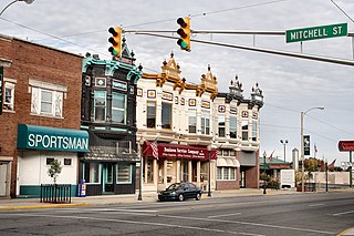
Butler is a city in DeKalb County, Indiana, United States. The population was 2,684 at the 2010 census.

<span class="mw-page-title-main">Kendallville, Indiana</span> City in Indiana, United States

Kendallville is a city in Wayne Township, Noble County, in the U.S. state of Indiana. The population was 10,205 at the 2021 census.

<span class="mw-page-title-main">Winchester, Indiana</span> City in Indiana, United States

Winchester is a city in White River Township, Randolph County, in the U.S. state of Indiana. The city is the county seat of Randolph County. The population was 4,935 at the 2010 census. It is the home of Winchester Speedway.

<span class="mw-page-title-main">Shelbyville, Indiana</span> City in Indiana, United States

Shelbyville is a city in Addison Township, Shelby County, in the U.S. state of Indiana and is the county seat. The population was 20,067 as of the 2020 census.

<span class="mw-page-title-main">Wabash, Indiana</span> City in Indiana, United States

Wabash is a city in Noble Township, Wabash County, in the U.S. state of Indiana. The population was 10,666 at the 2010 census. The city is situated along the Wabash River in the county seat of Wabash County.

<span class="mw-page-title-main">Aurora, Kansas</span> City in Cloud County, Kansas

Aurora is a city in Cloud County, Kansas, United States. As of the 2020 census, the population of the city was 56.

<span class="mw-page-title-main">Aurora, Minnesota</span> City in Minnesota, United States

Aurora is a city in Saint Louis County, Minnesota, United States. The population was 1,678 at the 2020 census.

<span class="mw-page-title-main">Aurora, Missouri</span> City in Missouri, United States

Aurora is a city in Lawrence County, Missouri, United States. As of the 2020 census, the population of the city was 7,432.

<span class="mw-page-title-main">Harrison, Ohio</span> City in Ohio, United States

Harrison is a city in western Hamilton County, Ohio, United States. The population was 12,563 at the 2020 census. It is part of the Cincinnati metropolitan area.

<span class="mw-page-title-main">Aurora, Ohio</span> City in Ohio, United States

Aurora is a city in northwestern Portage County, Ohio, United States. A suburb in between Akron and Cleveland, the population was 17,239 at the 2020 census. It is part of the Akron metropolitan area.

<span class="mw-page-title-main">Aurora, Oregon</span> City in Oregon, United States

Aurora is a city in Marion County, Oregon, United States. Before being incorporated as a city, it was the location of the Aurora Colony, a religious commune founded in 1856 by William Keil and John E. Schmit. William named the settlement after his daughter. The population was 1,133 at the 2020 Census. It is part of the Salem Metropolitan Statistical Area.

<span class="mw-page-title-main">North Vernon, Indiana</span> City in Indiana, United States

North Vernon is a city in Jennings County, Indiana, United States. The population was 6,608 as of the 2020 census.

<span class="mw-page-title-main">Homecroft, Indiana</span> Town in Indiana, United States

Homecroft is a town in Perry Township, Marion County, Indiana, United States. The population was 752 at the 2020 census. Incorporated in 1949, it has existed as an included town since 1970, when it was incorporated into Indianapolis as part of Unigov. It is part of Indianapolis, but retains a functioning town government under IC 36-3-1-11.

References

  1. "2020 U.S. Gazetteer Files". United States Census Bureau. Retrieved March 16, 2022.
  2. 1 2 U.S. Geological Survey Geographic Names Information System: Aurora, Indiana
  3. "G001 - Geographic Identifiers - 2010 Census Summary File 1". United States Census Bureau. Archived from the original on February 13, 2020. Retrieved July 28, 2015.
  4. 1 2 Shaw, Archibald (1915). History of Dearborn County, Indiana: Her People, Industries and Institutions. Unigraphic. p.  265.
  5. "Profile for Aurora, IN". ePodunk . Retrieved August 31, 2014.
  6. Hellmann, Paul T. (February 14, 2006). Historical Gazetteer of the United States. Routledge. p. 310. ISBN   1-135-94859-3.
  7. Scouting New York website, http://www.scoutingny.com/?p=2335
  8. Historic Hillforest website, "History". Archived from the original on July 26, 2011. Retrieved April 21, 2012.
  9. "National Register Information System". National Register of Historic Places . National Park Service. July 9, 2010.
  10. "Census of Population and Housing". census.gov. Retrieved June 4, 2015.
  11. "U.S. Census website". United States Census Bureau. Retrieved December 11, 2012.
  12. "U.S. Census website". United States Census Bureau . Retrieved January 31, 2008.
  13. Craig, Jason. "Elected Officials | Aurora, Indiana". aurora.in.us. Retrieved February 17, 2016.
  14. "Indiana public library directory" (PDF). Indiana State Library. Archived from the original (PDF) on February 18, 2017. Retrieved March 4, 2018.