Related Research Articles
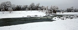
The Red River is a river in the north-central United States and central Canada. Originating at the confluence of the Bois de Sioux and Otter Tail rivers between the U.S. states of Minnesota and North Dakota, it flows northward through the Red River Valley, forming most of the border of Minnesota and North Dakota and continuing into Manitoba. It empties into Lake Winnipeg, whose waters join the Nelson River and ultimately flow into Hudson Bay.

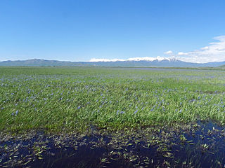
The Red River flood of 1997 was a major flood that occurred in April and May 1997 along the Red River of the North in Minnesota, North Dakota, and southern Manitoba. It was the most severe flood of the river since 1826. The flood reached throughout the Red River Valley, affecting the cities of Fargo and Winnipeg, but none so greatly as Grand Forks and East Grand Forks, where floodwaters reached more than 3 miles (4.8 km) inland. They inundated virtually everything in the twin communities. Total damages for the Red River region were US$3.5 billion. The flood was the result of abundant snowfall and extreme temperatures.
Twin Peaks is an American television series, running from 1990 to 1991; and in 2017.
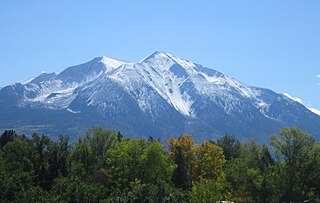
Mount Sopris is a twin-summit mountain in the northwestern Elk Mountains range of the Rocky Mountains of North America. The prominent 12,965-foot (3,952 m) mountain is located in the Maroon Bells-Snowmass Wilderness of White River National Forest, 6.6 miles (10.7 km) north by northeast of the community of Redstone in Pitkin County, Colorado, United States.

Ward Creek is a 6.1-mile (9.8 km) eastward-flowing stream in Placer County, California, United States. The creek flows into Lake Tahoe 2.7 miles (4.3 km) south of Tahoe City, California, and has undergone extensive restoration to reduce sediment and surface run-off to maintain the purity of Lake Tahoe.

Mount Baker Wilderness is a 119,989-acre (48,558 ha) wilderness area within the Mount Baker-Snoqualmie National Forest in the western Cascade Range of northern Washington state. Its eastern border is shared with the boundary of the Stephen Mather Wilderness and North Cascades National Park for a distance of 40 miles. The wilderness extends from State Route 20 north to the Canada–US border. On the west, it is bounded by the foothills of the Puget Sound lowlands.

Split Mountain is a fourteener in the Sierra Nevada of the U.S. state of California, near the southeast end of the Palisades group of peaks. It is the only fourteener in the watershed of the South Fork Kings River, and rises to 14,064 ft (4,287 m), making it the eighth-highest peak in the state.

The Sky Lakes Wilderness is a wilderness area located in the Rogue River–Siskiyou and Fremont–Winema national forests in the southern Cascade Range of Oregon in the United States. It comprises 116,300 acres (47,100 ha), of which 75,695 acres (30,633 ha) are in the Rogue River–Siskiyou National Forest and 40,605 acres (16,432 ha) are in the Fremont–Winema National Forest. It was established in 1984 under the Wilderness Act of 1964.

Twin Sisters Mountain, commonly called the Twin Sisters, is a mountain in the U.S. state of Washington. Part of the Cascade Range, it lies just southwest of Mount Baker. Of its two main peaks, South Twin is higher, with a summit elevation above 7,004 feet (2,135 m). The summit of North Twin is above 6,644 feet (2,025 m). There are several glaciers on the northeast slopes of Twin Sisters Mountain.
The Kaiser Wilderness is a federally designated wilderness protected area located 70 miles (110 km) northeast of Fresno in the state of California, USA. It was added to the National Wilderness Preservation System by the United States Congress on October 19, 1976. The wilderness is 22,700 acres (92 km2) in size, is one of five wilderness areas within the Sierra National Forest and is managed by the US Forest Service.
Mount Cramer, at 10,716 feet (3,266 m) is the second highest peak in the Sawtooth Range of Idaho. The summit of Mount Cramer is located on the border of Custer and Boise Counties. The peak is the highest point in Boise County. Mount Cramer is also located within the Sawtooth Wilderness portion of the Sawtooth National Recreation Area. The town of Stanley, Idaho is almost 14 miles (23 km) from Mount Cramer, while the area known as Sawtooth City is nearly 12 miles (19 km) from Mount Cramer. The west side of Mount Cramer drains into the South Fork of the Payette River, while the east side drains to the Salmon River.

Sacajawea Peak is a peak in the Wallowa Mountains, in the U.S. state of Oregon. It is in the Eagle Cap Wilderness and the Wallowa–Whitman National Forest.
The Salmon River Mountains are a major mountain range covering most of the central part of the U.S. state of Idaho. The range is over 120 miles (190 km) long and its boundaries are usually defined by the Salmon River and its large tributary forks. Part of the central Rocky Mountains, the entire range lies west of the Continental Divide of the Americas and drains to the Snake River. The highest peak is White Mountain, at 10,442 feet (3,183 m) above sea level. There are five peaks over 10,000 feet (3,000 m) high, and there are three major subranges defined by other forks of the Salmon River: the West, Central and East Salmon River Mountains.
Smoky Dome, at 10,095 feet (3,077 m) above sea level is the highest peak in the Soldier Mountains of Idaho. Smoky Dome is located northwest of Fairfield in Camas County and Sawtooth National Forest.

Iron Mountain, at 9,694 feet (2,955 m) high is one of the peaks of the Soldier Mountains of Idaho. Iron Mountain is located at the west end of the range northwest of Fairfield in Camas County and Sawtooth National Forest.
Boardman Peak, at 9,457 feet (2,882 m) high is one of the peaks of the Soldier Mountains of Idaho. Boardman Peak is located at the center of the range southeast of Iron Mountain, northwest of Smoky Dome, and northwest of Fairfield in Camas County and Sawtooth National Forest. No trails go to the summit, but several pass near the peak, and the ascent is only class 2.

Merriam Peak, at 10,920 feet (3,330 m) is one of the peaks of the White Cloud Mountains of Custer County, Idaho. It was named for John H. Merriam who played an instrumental role in protecting the area from being mined for molybdenum. Merriam Peak is located in the middle of the range just north of Castle Peak, the highest point in the range. The peak is located in the White Clouds roadless area of Sawtooth National Recreation Area.
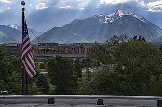
The Twin Peaks are a pair of mountain high points located on the Cottonwood Ridge within the Wasatch Range in Salt Lake County, Utah. They are usually referred to as the Broads Fork Twin Peaks, to distinguish them from the nearby American Fork Twin Peaks and Avenues Twin Peaks. Consisting of two sub-peaks, only the eastern peak has the prominence to be considered a true summit. The summit has an elevation of 11,303 feet (3,445 m), making it the second-highest peak in Salt Lake County, only behind the American Fork Twins. The summit rises directly from the Salt Lake Valley, making it easily visible and recognizable.

The Twin Peaks are a set of mountain high points located on the Alpine Ridge within the Wasatch Range in Utah, on the border between Salt Lake and Utah County. They are usually referred to as the American Fork Twin Peaks, to distinguish them from the nearby Broads Fork Twin Peaks and Avenues Twin Peaks. Consisting of several sub-peaks, only one has the prominence to be considered a true summit. The summit has an elevation of 11,461 feet (3,493 m), making it the highest point in Salt Lake County. The peak is also the most prominent in Salt Lake County, and one of the most prominent in the Wasatch Range.

Twining Peak is a 13,711-foot (4,179 m) mountain summit on the shared border of Pitkin County and Lake County, in Colorado, United States.
References
- 1 2 3 "Twin Peaks". Geographic Names Information System . United States Geological Survey, United States Department of the Interior . Retrieved February 17, 2022.