Babeldaob

Last updated
Babeldaob
Beach-in-melekeok20071222.jpg
Beach near Melekeok
Babeldaob Island, Palau, Relief.jpg
Map of Babeldaob Island
Palau location map.svg
Cercle rouge 100%25.svg
Babeldaob
Location of Babeldaob in Palau
Geography
Location Pacific Ocean
Archipelago Caroline Islands
Area331 km2 (128 sq mi)
Highest elevation242 m (794 ft)
Highest pointMount Ngerchelchuus
Administration

Babeldaob (also Babelthuap) is the largest island in the island nation of the Republic of Palau. It is in the western Caroline Islands, and the second largest island (after Guam) in the Micronesia region of Oceania. Palau's capital, Ngerulmud, is located on Babeldaob, in Melekeok State.

Contents

Babeldaob is one of the most underdeveloped populated islands in the Pacific Ocean. The area of Babeldaob, 331 km2 (128 sq mi), makes up over 70% of the land area of the entire Republic of Palau. It has about 30% of the country's population, with about 6,000 people living on it.

Geography

Babeldaob is located northeast of Koror Island, and its northern portion contains the site of the new national capital, Ngerulmud. The southern end of the island is in Airai State, Palau's second-most populous state. The Airai Airport on the island is the nation's principal airport.

The Koror-Babeldaob Bridge links Babeldaob Island at Airai to Koror Island.

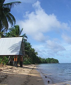
Unlike most of the islands of Palau, Babeldaob is mountainous. It contains Palau's highest point, the 242 m (794 ft)-tall Mount Ngerchelchuus. Babeldaob's eastern coast has many sandy beaches, in particular north from Melekeok to Ngaraard, and the island's western coast has a shoreline with many mangrove forests. [1]

Of the 16 states of Palau, Babeldaob encompasses 10, which are:

The Palau fruit dove is endemic to Palau and the country's national bird Palau Fruit Dove Ptilinopus pelewensis photographed on Babeldaob Palau in 2013 by Devon Pike (cropped).jpg
The Palau fruit dove is endemic to Palau and the country’s national bird

Environment

Important Bird Areas

The central forested Middle Ridge of Babeldaob encompasses the headwaters of most of the island’s watersheds. Some 13,767 ha in area, it has been designated an Important Bird Area (IBA) by BirdLife International because it supports populations of most of Palau’s endemic birds, including Micronesian megapodes, Palau ground doves, Micronesian imperial pigeons, Palau fruit doves, swiftlets, owls and kingfishers, Micronesian myzomelas, morningbirds, Palau fantails, flycatchers and bush warblers, dusky and citrine white-eyes, and Micronesian starlings. [2] The Western Ridge IBA adjoins Middle Ridge in the north-west of the island. This 2,608 ha site contains populations of the same bird species, [3] as does the 1,135 ha Ngerutechei IBA on the western side of the island, which also includes riverine mangrove habitat. [4]

History

First sighting of Babeldaob, Koror and Peleliu recorded by Europeans was by the Spanish expedition of Ruy López de Villalobos at the end of January 1543. They were then charted as Los Arrecifes ("The Reefs" in Spanish). [5] In November and December 1710 these three islands were again visited and explored by the Spanish missionary expedition commanded by Sargento Mayor Francisco Padilla on board of the patache Santísima Trinidad. Two years later they were explored in detail by the expedition of Spanish naval officer Bernardo de Egoy. [6] It was in the Spanish East Indies from 1686 to 1899.

As a consequence of the Spanish–American War, Spain sold Palau (including Babeldaob), the Carolines and the Northern Marianas (except Guam) to the German Empire for 17 million goldmark pursuant to the German–Spanish Treaty (1899). The newly acquired islands were administered from German New Guinea. Babeldaob was the destination to which the 426 members of the Sokehs tribe were banished by colonial authorities following the Sokehs Rebellion on Sokehs Island and Pohnpei.

In the early months of World War I, Imperial Japan occupied all German islands north of the equator. As a League of Nations mandatory power after the war, Japan returned the Sokehs to Pohnpei in stages between 1917 and 1927. [7]

During World War II a Japanese garrison on Babeldaob was composed of 21,449 Imperial Japanese Army men under the command of Lieutenant-General Sadae Inoue and 8,286 Imperial Japanese Navy men under the command of Vice-Admiral Kenmi Itoh. [8] Babeldaob was bypassed by the Allied forces during the war. [8]

See also

Notes

  1. Babeldaob information from Lonely Planet. Retrieved June 2009.
  2. "Middle Ridge, Babeldaob". BirdLife Data Zone. BirdLife International. 2021. Retrieved 3 March 2021.
  3. "Western Ridge, Babeldaob". BirdLife Data Zone. BirdLife International. 2021. Retrieved 3 March 2021.
  4. "Ngerutechei, Babeldaob". BirdLife Data Zone. BirdLife International. 2021. Retrieved 3 March 2021.
  5. Burney, James A chronological history of the discoveries in the South Sea or Pacific Ocean, London, 1813, v.I, p.233.
  6. Coello, Francisco "Conflicto hispano-alemán" Boletín de Sociedad Geográfica de Madrid, t.XIX. 2º semestre 1885, Madrid, p.296.
  7. Micronesian Seminar: The Sokehs Rebellion Archived 2017-06-13 at the Wayback Machine
  8. 1 2 Takizawa, Akira; Alsleben, Allan (1999–2000). "Japanese garrisons on the by-passed Pacific Islands 1944-1945". Forgotten Campaign: The Dutch East Indies Campaign 1941-1942.

Related Research Articles

<span class="mw-page-title-main">History of Palau</span> Historical account of the island country Palau

Palau was initially settled around 1000 BC.

<span class="mw-page-title-main">Koror</span> State in Palau

Koror is the state comprising the main commercial centre of the Republic of Palau. It consists of several islands, the most prominent being Koror Island. It is Palau’s most populous state.

<span class="mw-page-title-main">Airai</span> State in Palau

Airai, located on the southern coast of Babeldaob island, is the second-most populous state of Palau. It contains the country's chief airport, Roman Tmetuchl International Airport, and is connected by the Koror–Babeldaob Bridge to nearby Koror Island.

<span class="mw-page-title-main">Peleliu</span> State in Palau

Peleliu is an island in the island nation of Palau. Peleliu, along with two small islands to its northeast, forms one of the sixteen states of Palau. The island is notable as the location of the Battle of Peleliu in World War II.

<span class="mw-page-title-main">Angaur</span> State in Palau

Angaur, or Ngeaur in Palauan, is an island and state in the island nation of Palau.

<span class="mw-page-title-main">Aimeliik</span> State in Palau

Aimeliik is an administrative division of the island country of Palau. It is one of the Republic of Palau's 16 states. It has an area of 52 km2 and a population of 334. State capital is the village of Mongami. Following the four other villages which are: Medorm, Imul, Elechui and Ngmechiangel.

<span class="mw-page-title-main">Ngchesar</span> State in Palau

Ngchesar also known as Oldiais is one of the sixteen states of the nation of Palau in Oceania.

<span class="mw-page-title-main">Ngaraard</span> State in Palau

Ngaraard is the eighth state of the Republic of Palau, and was originally named Kerradel.

<span class="mw-page-title-main">Ngiwal</span> State in Palau

Ngiwal is one of the sixteen states of Palau. It has a population of 282 and an area of 26 km2

<span class="mw-page-title-main">Kapingamarangi</span> Atoll of the Federated States of Micronesia

Kapingamarangi is an atoll and a municipality in the state of Pohnpei of the Federated States of Micronesia. It is by far the most southerly atoll or island of the country and the Caroline Islands, 300 km (190 mi) south of the next southerly atoll, Nukuoro, and 740 km (460 mi) southwest of the main island of Pohnpei state; it forms a Polynesian outlier.

<span class="mw-page-title-main">Ngardmau</span> State in Palau

Ngardmau is one of Palau's sixteen states and is located on the west side of Babeldaob between the states of Ngaraard and Ngeremlengui.

<span class="mw-page-title-main">Roman Tmetuchl International Airport</span> Airport on the island of Palau

Roman Tmetuchl International Airport, also known as Palau International Airport is the main airport of Palau. It is located near the former capital Koror, just north of Ngetkib, Airai on Babeldaob island. The airport is 4 miles (6 km) from Koror and 15 miles (25 km) from Ngerulmud.

<span class="mw-page-title-main">Melekeok</span> State in Palau

Melekeok is a state of the Republic of Palau located on the central east coast of Babeldaob Island. The seat of government of the country, Ngerulmud, is located in the state. The state consists of long beaches, hills, steep ridges, rivers, and the largest and only natural freshwater lake in Palau and Micronesia, Lake Ngardok.

<span class="mw-page-title-main">Lake Ngardok</span>

Lake Ngardok is a lake on the Palauan island of Babeldaob, in the State of Melekeok. It is the largest natural freshwater lake in all of the islands of Micronesia. The lake and the marshes surrounding it are a refuge for the endangered saltwater crocodile (ius), and it is an important breeding location for them. The Ngerdorch River serves as a route that connects crocodiles with the sea. The lake is approximately 493 hectares with an ecosystem that provides a habitat for plants, wildlife, and birds, some of which are found only in the Palau Islands. These include the endemic Palau fruit dove (biib), Palau fantail (melimdelebdeb), Micronesian imperial-pigeon (belochel), common moorhens and Pacific black ducks, Palau flycatcher (charmelachull), and a fruit bat species (olik). The Chief Council of Melekeok State has established the Ngardok Nature Reserve to protect the watershed's slow degradation process, because the importance of the forests are critical to preserving the water quality in the lake. The lake however will soon be established as a reservoir for Ngerulmud, Palau's new national capital in Melekeok.

<span class="mw-page-title-main">Outline of Palau</span> Overview of and topical guide to Palau

The following outline is provided as an overview of and topical guide to Palau:

<span class="mw-page-title-main">Index of Palau-related articles</span>

The following is an alphabetical list of topics related to the Republic of Palau.

<span class="mw-page-title-main">Ngerulmud</span> Capital city of Palau

Ngerulmud is the seat of government of the Republic of Palau, an island nation in the Pacific Ocean. It replaced Koror City as a capital in 2006. The settlement is located in the state of Melekeok on Babeldaob, the country's largest island, located 20 kilometers northeast of Koror City and 2 km northwest of Melekeok City. It is the least-populous capital city of a sovereign nation in the world.

The sport of baseball is widely played in Palau, having been introduced by the Japanese during their occupation of the island nation. The highest level of league play in Palau in represented by Palau Major League (PML), which is overseen by the Belau Baseball Federation. The country is represented in international play by the Palau national baseball team.

<span class="mw-page-title-main">Effects of Typhoon Bopha in the Caroline Islands</span>

The effects of Typhoon Bopha in the Caroline Islands were significant, though limited in extent in comparison to the cyclone's intensity. Typhoon Bopha originated from a tropical depression south of Pohnpei on November 25, 2012, and tracked generally westward for more than a week. During this time, it threatened several islands across Micronesia, prompting the issuance of typhoon watches and warnings. The system skirted the Nomoi Islands on November 28 where it caused limited damage. Thereafter, it became a threat to Palau as an intense typhoon. Residents there boarded up their homes and some evacuated to public shelters while officials enacted a strict curfew during the typhoon's passage. Bopha passed 55 km (34 mi) south of Angaur island, or 100 km (62 mi) south of Babeldaob, on December 2 with winds of 185 km/h (115 mph).

<span class="mw-page-title-main">Ministry of Education (Palau)</span> Government ministry in Palau

The Ministry of Education is a government agency of Palau, headquartered in Koror City.

References

7°31′49″N134°33′53″E / 7.53028°N 134.56472°E / 7.53028; 134.56472